
The Frederick G. Gardiner Expressway, commonly known as the Gardiner Expressway or simply the Gardiner, is a partially at grade and elevated municipal expressway in Toronto, Ontario, Canada. Running close to the shore of Lake Ontario, it extends from the foot of the Don Valley Parkway (DVP) in the east, just past the mouth of the Don River, to the junction of Highway 427 and the Queen Elizabeth Way (QEW) in the west, for a total length of 18.0 kilometres (11.2 mi). East of Dufferin Street to just east of the Don River, the roadway is elevated for a length of 6.8 kilometres (4.2 mi), unofficially making it the longest bridge in Ontario.

Harbourfront is a neighbourhood on the northern shore of Lake Ontario within downtown Toronto, Ontario, Canada. Part of the Toronto waterfront, Harbourfront extends from Bathurst Street in the west, along Queens Quay, with its ill-defined eastern boundary being either Yonge Street or York Street. Its northern boundary is the Gardiner Expressway. Much of the district was former water lots filled in during the early 1900s to create a larger harbour district. After shipping patterns changed and the use of the Toronto Harbour declined, the area was converted from industrial uses to a mixed-use district that is mostly residential and leisure.

The Toronto waterfront is the lakeshore of Lake Ontario in the city of Toronto, Ontario, Canada. It spans 46 kilometres between the mouth of Etobicoke Creek in the west and the Rouge River in the east.

Mailbox Birmingham, also known as The Mailbox, is a mixed-use development located within the city centre of Birmingham, England. It houses British luxury department store chain Harvey Nichols, and the BBC Birmingham studios.

Grange Park is a prominent and well-used public park in downtown Toronto, Ontario in Canada. It is located south of the Art Gallery of Ontario, next to the Ontario College of Art and Design University (OCADU) and north of University Settlement House, at the north end of John Street. The Park lends its name to the Grange Park neighbourhood in the vicinity of the park. Historically, the park was the backyard of The Grange, a manor that was later expanded and became the Art Gallery of Ontario.

Toronto Parks, Forestry & Recreation (PFR) is the division of Toronto's municipal government responsible for maintaining the municipal park system and natural spaces, regulation of and provision of urban forestry services, and the delivery of recreational programming in city-operated facilities.

Louisville Waterfront Park is both a non-profit organization and an 85-acre (340,000 m2) public park adjacent to the downtown area of Louisville, Kentucky and the Ohio River. Specifically, it is adjacent to Louisville's wharf and Riverfront Plaza/Belvedere, which are situated to the west of the park. Once a wasteland of scrap yards and abandoned industrial buildings, Waterfront Park is now a vibrant green space that welcomes over 2.2 million visitors each year. Located in the park is the Big Four Bridge which connects the city of Louisville with the City of Jeffersonville, Indiana. Waterfront Park is home to some of Louisville's most exciting celebrations, such as the Fourth of July at Waterfront Park, Forecastle Festival, WFPK Waterfront Wednesdays and Thunder Over Louisville. In 2013 the park won the Rudy Bruner Award for Urban Excellence a national design award that seeks to identify and honor places that address economic and social concerns in urban design.

CityPlace is a neighbourhood in Downtown Toronto, Ontario, Canada, within the former Railway Lands. When completed, this area will be the largest residential development ever created in Toronto. The area is bordered by Bathurst Street to the west, Lake Shore Boulevard to the south, and Front Street to the north and Blue Jays Way and Rogers Centre to the east. Cityplace is also a five-to-ten-minute walk from King Street West and Liberty Village and a ten-to-twenty-minute walk from Toronto's financial district. The neighbourhood is also home to the Canoe Landing Park, designed by famed Canadian writer and artist Douglas Coupland.

Ping Tom Memorial Park is a 17.24-acre (6.98 ha) public urban park in Chicago's Chinatown neighborhood, in South Side, Chicago. It is part of the Chicago Park District (CPD).

The West Don Lands are the site of a neighbourhood under construction in Toronto, Ontario, Canada. The area is bordered by the Don River, King Street, Parliament Street and the rail line adjacent to the Gardiner Expressway. It is 80 hectares in size. A former industrial area, the area is being rebuilt as a mixed-use neighbourhood.
Waterfront Toronto is an organization that oversees revitalization projects along the Toronto waterfront. Established in 2001 as a public–public partnership between the City of Toronto, Province of Ontario and Government of Canada, the organization is administering several blocks of land redevelopment projects surrounding Toronto Harbour and various other initiatives to promote the revitalization of the area, including public transit, housing developments, brownfield rehabilitation, possible removal of the Gardiner Expressway in the area, the Martin Goodman Trail and lakeshore improvements, and naturalization of the Don River. Actual development of the projects is done by other entities, primarily private corporations. The projects include a series of wavedeck walkways and gathering places designed by West 8 and DTAH.

The Doha Corniche is a waterfront promenade and dual carriageway extending for seven kilometres (4.3 mi) along the crescent-shaped Doha Bay in Qatar's capital city, Doha. A lush, semi-circular linear public space, the Corniche serves as the central location for national celebrations, including Qatar National Day Parade and National Sports Day, as well as various religious, civic, and sporting events, making it one of the most popular tourist and recreational destinations in Qatar.
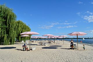
Sugar Beach is an urban beach park in Toronto, Ontario, Canada, that opened in 2010. It is located across from Redpath Sugar Refinery in Toronto's eastern East Bayfront. Like HTO Park to the west, the beach is not meant for wading or swimming in Lake Ontario, but rather functions as a waterfront public space for relaxation, leisure, and social activities. It cost $14 million.
The Simcoe Street tunnel is located between Front Street and Bremner Blvd. in Toronto, Ontario, Canada. This CA$40 million tunnel is situated in a densely urban site below the SkyWalk and in close proximity to Toronto Union Station and the InterContinental Toronto Centre hotel. The tunnel roof structure is designed to carry all 16 pre-existing railway tracks. The ground structure provides one vehicle lane north bound and two lanes south bound, one bicycle lane and one extra wide pedestrian sidewalk on each side of the tunnel.

The East River Greenway is an approximately 9.44-mile-long (15.19 km) foreshoreway for walking or cycling on the east side of the island of Manhattan on the East River. It is part of the Manhattan Waterfront Greenway. The largest portions are operated by the New York City Department of Parks and Recreation. It is separated from motor traffic, and many sections also separate pedestrians from cyclists. The greenway is parallel to the Franklin D. Roosevelt East River Drive for a majority of its length.
East Bayfront LRT, also known as the Waterfront East LRT, is a planned Toronto streetcar line that would serve the East Bayfront and Port Lands areas in Toronto, Ontario, Canada. It would run from Union station under Bay Street and along Queens Quay and Cherry Street to a new loop along Commissioners Street east of Cherry Street on Ookwemin Minising. It would complement the existing 509 Harbourfront service that connects Union Station to Queens Quay west of Bay Street. Longer-term plans are to extend the East Bayfront line from Cherry and Commissioners Streets to the planned East Harbour Transit Hub along GO Transit's Lakeshore East line and the planned Ontario Line.

Ontario Place was an entertainment venue, event venue, and park in Toronto, Ontario, Canada. The venue is located on three artificial landscaped islands just off-shore in Lake Ontario, south of Exhibition Place, and southwest of Downtown Toronto. It opened on May 22, 1971, and operated as a theme park centred around Ontario themes and family attractions until 2012 when the Government of Ontario announced that it would close for redevelopment. It has since reopened as a park without an admission fee but without several of the old attractions. The Government of Ontario has made controversial plan to place the 145 acres on a 95-year lease with the Swiss mega-spa builderTherme Group without public consultation or environmental assessments.

The Jack Layton Ferry Terminal is the ferry slip for Toronto Island ferries operated by the City of Toronto Parks, Forestry and Recreation Division. Three ferry routes provide transportation between mainland Toronto and Centre Island, Hanlan's Point and Ward's Island in the Toronto Islands, with levels of service to each destination differing depending on time of year. The terminal is located in the Toronto Harbour, behind the Westin Harbour Castle Hotel and adjacent to Harbour Square Park. It is south of Bay Street and Queens Quay in Toronto, Ontario, Canada.

Pier 42 is a pier in the Lower East Side of Manhattan, New York City. It was the last working cargo pier on the Manhattan shore of the East River, operating from 1963 to 1987. Since the early 2010s, plans have been underway to turn Pier 42 into a park.
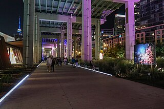
The Bentway, formerly Project: Under Gardiner, is a public trail and corridor space underneath the Gardiner Expressway in Toronto, Ontario, Canada. It is repurposed land that was in sections vacant, rail lines, parking lots and outdoor storage.

