
The Junction is a neighbourhood in Toronto, Ontario, Canada, that is near the West Toronto Diamond, a junction of four railway lines in the area. The neighbourhood was previously an independent city called West Toronto, that was also its own federal electoral district until amalgamating with the city of Toronto in 1909. The main intersection of the area is Dundas Street West and Keele Street. The Stockyards is the northeastern quadrant of the neighbourhood.

Leaside (/'liːˌsaɪd/) is an affluent neighbourhood in Toronto, Ontario, Canada. It is located northeast of Downtown Toronto, in the vicinity of Eglinton Avenue East and Bayview Avenue. The area takes its name from William Lea and the Lea family, who settled there in the early years of the 19th century. The area first developed as farmland along with Toronto through the 19th century. It was incorporated as a town in 1913. In 1967, it amalgamated with the township of East York to form the borough of East York. In 1998, it became part of the city of Toronto. It is commonly seen as one of the most expensive and exclusive neighbourhoods in the city with a median household income of $129,930, serving upper-middle-class families.

North Toronto is a former town and informal district located in the northern part of the Old Toronto district in Toronto, Ontario, Canada. Currently occupying a geographically central location within the city of Toronto, the Town of North Toronto was incorporated in 1890, when much of the area was still farmland, and annexed by the old city of Toronto in 1912. The name is still used to refer to the area in general, although Yonge–Eglinton and Midtown Toronto are officially used.

Deer Park is an affluent neighbourhood in Toronto, Ontario, Canada, centred on the intersection of Yonge Street and St. Clair Avenue. Its boundaries are the Vale of Avoca section of Rosedale ravine in the east, Farnham Avenue and Jackes Avenue in the south, Avenue Road and Oriole Parkway in the west, the Beltline Trail in the north on the west side of Yonge Street, and Glen Elm Avenue in the north on the east side of Yonge Street. For the purposes of social policy analysis and research, the Toronto government’s Social Development & Administration division includes Deer Park within the City of Toronto's official "Rosedale-Moore Park" and "Yonge-St.Clair" neighbourhood profiles. The neighbourhood is in Ward 22, represented by Councillor Josh Matlow at Toronto City Council.

Parkdale—High Park is a federal electoral district in Ontario, Canada, that has been represented in the House of Commons of Canada since 1979. It was created during the 1976 electoral boundaries redistribution from parts of Parkdale, High Park—Humber Valley, Davenport and Spadina districts. As of the October 19, 2015, Canadian general election, the current Member of Parliament (MP) is Liberal member Arif Virani. According to the 2016 Census, Parkdale—High Park has the lowest percentage of visible minorities (26.2%) among all City of Toronto ridings; it also has the highest percentage of people of Irish (20.0%), German (9.8%), and French (8.9%) ethnic origin of all City of Toronto ridings.

Bayview Village is an affluent neighbourhood in Toronto, Ontario, Canada. It is part of the federal Don Valley North riding and the provincial Don Valley North electoral district, and Toronto electoral Ward 17: Don Valley North. In 2006, it had a population of 15,370.

Dovercourt Park or Dovercourt Village is a neighbourhood in Toronto, Ontario, Canada situated north of Bloor Street between Christie Street to the east, the CPR railway lines to the north, and Dufferin Street to the west.
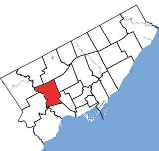
York South—Weston is a federal electoral district in Ontario, Canada, that has been represented in the House of Commons of Canada since 1979.
The Toronto Suburban Railway was a Canadian electric railway operator with local routes in west Toronto, and a radial (interurban) route to Guelph.

The West Toronto Railpath is a multi-use trail in Toronto, Ontario, Canada, running from The Junction neighbourhood toward downtown Toronto. The Railpath was developed by the City of Toronto for bicycle and pedestrian use. Like Toronto's Beltline and Don Mills trails, it is an urban rail-to-trail project. Phase 1 of the path opened in 2009. Phase 2, an extension south from Dundas Street West to Liberty Village, was approved and proceeding with detailed design as of September 2020 with funding of $2.9 million jointly from the City and the Government of Canada. Construction of Phase 2 is expected to begin in 2021 or 2022.

Downtown Toronto is the main central business district of Toronto, Ontario, Canada. Located entirely within the district of Old Toronto, it is approximately 16.6 square kilometres in area, bounded by Bloor Street to the northeast and Dupont Street to the northwest, Lake Ontario to the south, the Don Valley to the east, and Bathurst Street to the west. It is also the home of the municipal government of Toronto and the Government of Ontario.

York University Heights, also known as Northwood Park, is a neighbourhood in Toronto, Ontario, Canada. It is one of Toronto's northernmost neighbourhoods, located along the northern boundary of Steeles Avenue in the former city of North York. The neighbourhood is so named because it contains the main campus of York University. This area is most popular with immigrants of Italian and Chinese descent who have established communities in the area. It is located between Sheppard Avenue and Steeles Avenue east of Black Creek.
Victoria Village, sometimes referred to as Sloane, is a neighbourhood in the city of Toronto, Ontario, Canada bounded on the west by the Don Valley, on the north by Lawrence Avenue East, on the east by Victoria Park Avenue, and on the south by Eglinton Avenue East, although there is a small area south of Eglinton to Sunrise Avenue that is sometimes included. It is located in the southeast of the former city of North York. Its population is diverse in ancestral backgrounds with a larger proportion of South Americans than most of the city.

Don Valley Village is a neighbourhood in the city of Toronto, Ontario, Canada. It is located in the former suburb of North York. It is located north of Highway 401, and is bounded by Sheppard Avenue to the south, Leslie Street to the west, Finch Avenue to the north and Highway 404 to the east. Like the nearby Don River Valley, the neighbourhood has hill and dale topography.
Ionview is a neighbourhood in Toronto, Ontario, Canada, in the district of Scarborough. It is bounded by Birchmount Road to the west, the hydro transmission corridor north of Ranstone Gardens to the north, the CNR railway to the east, and Eglinton Avenue East, Kennedy Road and the CNR railway to the south.

Lytton Park is a neighbourhood in Toronto, Ontario, Canada. It is located in the "North Toronto" municipality, within the former city of Toronto. The neighbourhood is centered on 'Lytton Park'. Its boundaries include: Mona Drive to the west, Yonge Street to the east, Lawrence Avenue West to the north and Briar Hill Avenue to the south.

High Park North, or often simply High Park, after the park, is a neighbourhood in Toronto, Ontario, Canada. It is bounded on the south by Bloor Street, on the west by Runnymede Road, on the north by Annette Street, Quebec Avenue and Humberside Avenue, and on the east by the GO Transit Weston Subdivision rail tracks. It is located in the Parkdale—High Park provincial and federal electoral districts. The area east of Keele Street is also known informally as the "West Bend" neighbourhood.
Runnymede Road is a street in the west end of Toronto, Canada. It runs from Morningside Avenue at its south end and ends at Henrietta Street, north of St. Clair Ave.

Governor's Bridge is a bridge and small neighbourhood in Toronto, Ontario, Canada, located to the east of Rosedale and Moore Park neighbourhoods. Unlike them, it was part of the former city of East York. The neighbourhood is named for the Governor's Bridge that crosses the Moore Park Ravine from Douglas Crescent to Astley Avenue and connects the area to Rosedale. The bridge was built in 1923 and restored in 2000.

Runnymede is a neighbourhood in Toronto, Ontario, Canada located north of Bloor Street West between Jane Street and Runnymede Road north to Dundas Street West. It is located directly north of the former village of Swansea and west of the High Park North neighbourhood. The immediate area around Bloor Street is commonly known as Bloor West Village after the shopping area along Bloor Street, whereas the area to the north is considered the Runnymede neighbourhood.

