
Scarborough is a district of Toronto, Ontario, Canada. It is situated atop the Scarborough Bluffs in the eastern part of the city. Its borders are Victoria Park Avenue to the west, Steeles Avenue and the city of Markham to the north, Rouge River and the city of Pickering to the east, and Lake Ontario to the south. Scarborough was named after the English town of Scarborough, North Yorkshire, inspired by its cliffs.

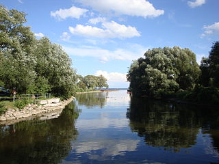
The Rouge River is a river in Markham, Pickering, Richmond Hill and Toronto in the Greater Toronto Area of Ontario, Canada. The river flows from the Oak Ridges Moraine to Lake Ontario at the eastern border of Toronto, and is the location of Rouge Park, the only national park in Canada within a municipality. At its southern end, the Rouge River is the boundary between Toronto and southwestern Pickering in the Regional Municipality of Durham.
Port Union, also known as Centennial Scarborough is a neighbourhood in Toronto, Ontario, Canada. It is located in the south-east corner of Toronto, within the former suburb of Scarborough. The neighbourhood is bounded by Kingston Road to the north, Port Union Road to the east, the Lake Ontario shoreline to the south, and Highland Creek to the west.

The Toronto waterfront is the lakeshore of Lake Ontario in the city of Toronto, Ontario, Canada. It spans 46 kilometres between the mouth of Etobicoke Creek in the west and the Rouge River in the east.

Malvern is a neighbourhood in the city of Toronto, Ontario, Canada, with a population of 44,315. It is located in the northeast corner of the city.

West Hill is a neighbourhood in Toronto, Ontario, Canada. It is located in the eastern end of the city, in the former suburb of Scarborough. It is roughly bounded by Scarborough Golf Club Road and a branch of Highland Creek on the west, the CNR railway tracks and Lake Ontario on the south, and Highland Creek on the north-east. The name comes from its elevated position on the west side of Highland Creek, a deep glacial ravine.

The cancelled expressways in Toronto were a planned series of expressways in Toronto, Ontario, Canada that were only partially built or cancelled due to public opposition. The system of expressways was intended to spur or handle growth in the suburbs of Toronto, but were opposed by citizens within the city of Toronto proper, citing the demolition of homes and park lands, air pollution, noise and the high cost of construction. The Spadina Expressway, planned since the 1940s, was cancelled in 1971 after being only partially constructed. After the Spadina cancellation, other expressway plans, intended to create a 'ring' around the central core, were abandoned.
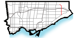
Morningside Avenue is a suburban arterial road in Toronto, Ontario, Canada. It is entirely within Scarborough, running north by north-west from the Scarborough Bluffs overlooking Lake Ontario to the eastern terminus of McNicoll Avenue near the Rouge River valley. A short extension from Steeles Avenue to Passmore Avenue has been completed but the connection to the southern section to McNicoll Avenue is still not completed.

The Scarborough Bluffs, also known as The Bluffs, is an escarpment in the Scarborough district of Toronto, Ontario, Canada. There are nine parks along the bluffs, with Bluffers Park being the only one with a beach. Forming much of the eastern portion of Toronto's waterfront, the Scarborough Bluffs stands above the shoreline of Lake Ontario. At its highest point, the escarpment rises 90 metres (300 ft) above the coastline and spans a length of 15 kilometres (9.3 mi).
The Toronto and Region Conservation Authority (TRCA) is a conservation authority in southern Ontario, Canada. It owns about 16,000 hectares of land in the Toronto region, and it employs more than 400 full-time employees and coordinates more than 3,000 volunteers each year. TRCA's area of jurisdiction is watershed-based and includes 3,467 square kilometres (1,339 sq mi) – 2,506 on land and 961 water-based in Lake Ontario. This area comprises nine watersheds from west to east – Etobicoke Creek, Mimico Creek, Humber River, Don River, Highland Creek, Petticoat Creek, Rouge River, Duffins Creek and Carruthers Creek.

West Rouge is a neighbourhood in Toronto, Ontario, Canada. It is located in the south-east corner of Toronto, within the former city of Scarborough. The community is roughly bounded by Lake Ontario to the south, the Rouge River and the Rouge National Urban Park to the east, Port Union Road to the west and Kingston Road to the north.

Steeles is a suburban neighbourhood in Toronto, Ontario, Canada. Steeles is located in the north-eastern part of Toronto in the former suburb of Scarborough. To the north is bordered by Steeles Avenue East, to the east by Kennedy Road, to the south by a hydro-electric transmission line and to the west by Victoria Park Avenue.

Tam O'Shanter-Sullivan is a neighbourhood in the east end of the city of Toronto, Ontario, Canada, in the district of Scarborough. The neighbourhood is bordered by Huntingwood Drive to the North, Kennedy Road to the East, Highway 401 to the South and Victoria Park to the West. The neighbourhood, which includes the Tam O'Shanter and Sullivan communities, takes its name from Tam O’Shanter Golf Course and O'Sullivan's Corners.

Morningside, also known as Seven Oaks, is a suburban neighbourhood in the city of Toronto, Ontario, Canada. It is located to the north-east of downtown Toronto, in the suburb of Scarborough. Morningside is bordered by Highway 401 to the north, Morningside Avenue to the east, West Highland Creek and Lawrence Avenue to the south and Scarborough Golf Club Road to the west.

Woburn is a neighbourhood located in eastern Toronto, Ontario, Canada, in the former suburb of Scarborough. Woburn is bordered by Highway 401 to the north, Orton Park Road to the east, Lawrence Avenue to the south, and McCowan Road to the west.

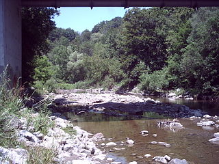
Highland Creek is a river in the Scarborough district of Toronto, Ontario, emptying into Lake Ontario at the eastern end of the Scarborough Bluffs. It is home to several species of fish including trout, carp, bass and salmon. It is a meandering river which, like most rivers in Toronto, travels through a glacial ravine formed after the last Ice Age. The Highland Creek watershed, including tributaries, is almost entirely contained within Scarborough.

Highland Creek is a neighbourhood in eastern Toronto, Ontario, Canada. It is located along the southern portion of the river of the same name in the former suburb of Scarborough. To the east are the neighbourhoods of Port Union and West Rouge, to the west West Hill and Woburn, and to the south Centennial Scarborough.
West Highland Creek is a river in Toronto, Ontario, Canada, and is a tributary of Highland Creek in the Lake Ontario drainage basin. The creek and its tributaries are entirely within the old City of Scarborough, and provide the watershed for the northwest of the city.
Marie Curtis Park is a public park in Toronto, Ontario, Canada. It is located at the mouth of the Etobicoke Creek on Lake Ontario in the Long Branch neighbourhood. Marie Curtis Park was built after the devastating floods of Hurricane Hazel in 1954 destroyed 56 homes and cottages on the site, leaving 1,868 persons homeless and 81 dead. It is named after Marie Curtis, the reeve of Long Branch at the time of its construction. Long Branch at the time was a separate village; it's now amalgamated into the City of Toronto government.

