Highland Creek, Toronto

Last updated

Highland Creek
Neighbourhood
Highland Creek Valley at Kingston Road.jpg
Highland Creek map.PNG
Toronto map.png
Red pog.svg
Highland Creek
Location in Toronto
Coordinates: 43°47′21″N79°10′29″W / 43.78917°N 79.17472°W / 43.78917; -79.17472 [1]
CountryFlag of Canada (Pantone).svg  Canada
ProvinceFlag of Ontario.svg  Ontario
City Toronto
Established municipality1850 Scarborough Township
Changed municipality1998 Toronto from City of Scarborough
Government
   MP Gary Anandasangaree (Scarborough—Rouge Park)
   MPP Mitzie Hunter (Scarborough-Guildwood)
   Councillor Paul Ainslie (Ward 43 Scarborough East)

Highland Creek is a neighbourhood in eastern Toronto, Ontario, Canada. [1] It is located along the southern portion of the river of the same name in the former suburb of Scarborough. To the east are the neighbourhoods of Port Union and West Rouge, to the west West Hill and Woburn, and to the south Centennial Scarborough.

Contents

The western portion of the neighbourhood is occupied by the University of Toronto Scarborough, a feature landmark in the area and a busy pedestrian centre. After the opening of the college, the neighbourhood was developed primarily into residential areas. Areas dominated by wildlife, which is located along the Highland Creek valley, were left alone. Some shops and a church exist along the commercial Old Kingston Road.

The community is one of the most prestigious neighbourhoods in Scarborough with wide lot homes.[ citation needed ] Home prices are relatively expensive compared to other areas of Scarborough. This partly due to the location of the university.

History

In 1966, the University of Toronto opened its Scarborough campus in Highland Creek. John Andrews Building Scarborough 2010 (2).jpg
In 1966, the University of Toronto opened its Scarborough campus in Highland Creek.

Like many creeks and river valleys in Toronto, evidence of First Nations occupation has been found in this area. A 2005 excavation by the Toronto and Region Conservation Authority near the mouth of Highland Creek found evidence of a Late Woodland or Early Archaic site, thought to have been a place of tool manufacture. The Helliwell family, one of the first settlers in the area, accumulated a large number of artifacts from the last 5,000 years. [2]

The Highland Creek area was one of the first areas to be occupied by European settlers in the area of what would later become the Township of Scarborough. This is mainly due to the presence of Highland Creek, the river that runs through the neighbourhood, whose valley is occupied by large trees and wildlife. During the 18th and early-19th centuries, the area was home to vast farmlands and homes. In 1954, Hurricane Hazel destroyed many dwellings in the area and contributed to the flooding of the creek.

In 1963, the University of Toronto purchased the western part of the land from E. L. MacLean, who acquired the land from its original owner Miller Lash, a businessman from Old Toronto who built an estate on the land, now known as the Miller Lash House, in 1911. The university eventually built and opened the Scarborough College, which is today known as University of Toronto Scarborough, a satellite campus of the university. The campus was opened in 1965.

Education

Highland Creek Public School is one of four elementary schools located in the neighbourhood. Highland Creek Public School (Highland Creek).jpg
Highland Creek Public School is one of four elementary schools located in the neighbourhood.

Two public school boards operate elementary schools in Highland Creek, the separate Toronto Catholic District School Board (TCDSB), and the secular Toronto District School Board (TDSB). TDSB operates three public elementary schools, Highland Creek, Meadowvale, and Morrish Public School. TCDSB operates one elementary school in the area, Cardinal Leger Catholic School.

Neither TCDSB, or TDSB operate a secondary school in the neighbourhood, with TCDSB/TDSB students residing in the neighbourhood attending secondary schools in adjacent areas. The French-first language public secular school board, Conseil scolaire Viamonde, and it separate counterpart, Conseil scolaire catholique MonAvenir also offer schooling to applicable residents of Highland Creek, although they do not operate a school in the neighbourhood, with CSCM/CSV students attending schools situated in other neighbourhoods in Toronto.

Along with elementary schools, the area is also home to two public post-secondary institutions operate a campus in Highland Creek. Centennial College's Morningside Campus is located along Highland Creek's western boundary on Morningside Avenue. The University of Toronto also operates a satellite campus in the neighbourhood, the University of Toronto Scarborough.

Transportation

A TTC bus stop in front on Ellesmere Road and Morningside Avenue. Centennial College Science Technology Centre.jpg
A TTC bus stop in front on Ellesmere Road and Morningside Avenue.

As it is located along Old Kingston Road, which was a former provincial highway that connected Toronto and Kingston, Ontario, it is home to some of the oldest buildings in Scarborough. Ontario Highway 2A runs just south of the neighbourhood's core. Other major roadways in the neighbourhood include Meadowvale Road, and Morningside Avenue, which also acts as the neighbourhood's western boundary. Highway 401 is a major east–west controlled access highway that bisects Greater Toronto.

Public transit

Toronto Transit Commission (TTC) bus route 38 is named after the neighbourhood and runs 7 days a week, between Scarborough Centre station and the Rouge Hill GO Station, along Ellesmere Road, Military Trail, Lawson Road, and Port Union Road. 12 Kingston Road, 54 Lawrence East, 85 Sheppard East, 86 Scarborough, 95 York Mills, 116 Morningside, 905 Eglinton East Express, 954 Lawrence East Express, 986 Scarborough Express, and 995 York Mills Express also serve parts of the neighbourhood. GO Transit commuter coach route 51, and Durham Region Transit routes 900 and 923 may be accessed at the University of Toronto Scarborough.

Amenities

Snappy Food Mart, located at the corner of Morrish Road and Ellesmere, where there is also a Toronto Public Library branch. [3]

The Toronto Pan Am Sports Centre serves the community and is owned by both the city of Toronto and the University of Toronto Scarborough. [4]

See also

Related Research Articles

<span class="mw-page-title-main">Bendale</span> Neighbourhood in Toronto, Ontario, Canada

Bendale, also called Cedarbrae and Midland Park, is a residential neighbourhood in the eastern part of Toronto, Ontario, Canada. It is located in the former suburb of Scarborough. It is centred on the intersection of Lawrence Avenue East and Brimley Road. Its boundaries, as defined by the City, are Midland Avenue from Lawrence, north to Highway 401, east to McCowan, south to Lawrence, east to West Highland Creek, south-west along West Highland Creek, then follow several side streets parallel to the Creek, north to Midland Avenue. The area north of Ellesmere is typically considered the Scarborough City Centre district, and is not considered in this neighbourhood article.

<span class="mw-page-title-main">Agincourt, Toronto</span> Neighbourhood in Toronto, Ontario, Canada

Agincourt is a neighbourhood and former village in Toronto, Ontario, Canada. Agincourt is located in northeast Toronto, along Sheppard Avenue between Kennedy and Markham Roads. Before the creation of the "megacity" of Toronto in 1998, the area was part of Scarborough. It is officially recognized by the City of Toronto as occupying the neighbourhoods of Agincourt South–Malvern West and Agincourt North.

<span class="mw-page-title-main">Port Union, Toronto</span> Neighbourhood in Toronto, Ontario, Canada

Port Union, also known as Centennial Scarborough is a neighbourhood in Toronto, Ontario, Canada. It is located in the south-east corner of Toronto, within the former suburb of Scarborough. The neighbourhood is bounded by Kingston Road to the north, Port Union Road to the east, the Lake Ontario shoreline to the south, and Highland Creek to the west.

<span class="mw-page-title-main">Cliffside, Toronto</span> Neighbourhood in Toronto, Ontario, Canada

Cliffside is a neighbourhood in Toronto, Ontario, Canada, located along the Scarborough Bluffs in the district of Scarborough. Its boundaries are Kennedy Road to the west, St. Clair Avenue East to the north, Brimley Road to the east, and the Bluffs on the lakeshore to the south.

<span class="mw-page-title-main">Malvern, Toronto</span> Neighbourhood in Toronto, Ontario, Canada

Malvern is a neighbourhood in the city of Toronto, Ontario, Canada, with a population of 44,315. It is located in the northeast corner of the city.

<span class="mw-page-title-main">West Hill, Toronto</span> Neighbourhood in Toronto, Ontario, Canada

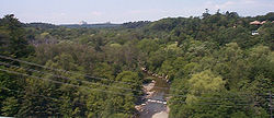
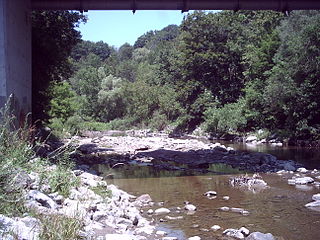
West Hill is a neighbourhood in Toronto, Ontario, Canada. It is located in the eastern end of the city, in the former suburb of Scarborough. It is roughly bounded by Scarborough Golf Club Road and a branch of Highland Creek on the west, the CNR railway tracks and Lake Ontario on the south, and Highland Creek on the north-east. The name comes from its elevated position on the west side of Highland Creek, a deep glacial ravine.

<span class="mw-page-title-main">Scarborough Village</span> Neighbourhood in Toronto, Ontario, Canada

Scarborough Village is a neighbourhood in Toronto, Ontario, Canada, located in the Scarborough district. It was one of the earliest settlements in the former township of Scarborough with the distinction of being the site of the township's first post office. Today, the neighbourhood is composed of private and public housing, apartment complexes, schools, a few condominiums, and strip mall plazas. The neighbourhood lies along the Scarborough Bluffs escarpment.

<span class="mw-page-title-main">Lawrence Manor</span> Neighbourhood in Toronto, Ontario, Canada

Lawrence Manor is a neighbourhood in the city of Toronto, Ontario, Canada. This neighbourhood is bounded by Bathurst Street on the east, Highway 401 to the north, the Allen to the west, and Lawrence Avenue to the south. The western side of the area borders along Bathurst Heights and the large public housing project.

<span class="mw-page-title-main">Hillcrest Village</span> Neighbourhood in Toronto, Ontario, Canada

Hillcrest Village is a neighbourhood located in Toronto, Ontario, Canada. It is located in the northern district of North York. It is bordered by Finch to the South, Leslie Street to the West, Steeles to the North and Victoria Park to the East. Both neighbourhoods share the Don Valley as a point of reference in the Eastern border of the neighbourhoods.

<span class="mw-page-title-main">West Rouge</span> Neighbourhood in Toronto, Ontario, Canada

West Rouge is a neighbourhood in Toronto, Ontario, Canada. It is located in the south-east corner of Toronto, within the former city of Scarborough. The community is roughly bounded by Lake Ontario to the south, the Rouge River and the Rouge National Urban Park to the east, Port Union Road to the west and Kingston Road to the north.

<span class="mw-page-title-main">Steeles, Toronto</span> Neighbourhood in Toronto, Ontario, Canada

Steeles is a suburban neighbourhood in Toronto, Ontario, Canada. Steeles is located in the north-eastern part of Toronto in the former suburb of Scarborough. To the north is bordered by Steeles Avenue East, to the east by Kennedy Road, to the south by a hydro-electric transmission line and to the west by Victoria Park Avenue.

<span class="mw-page-title-main">Tam O'Shanter-Sullivan</span> Neighbourhood in Toronto, Ontario, Canada

Tam O'Shanter-Sullivan is a neighbourhood in the east end of the city of Toronto, Ontario, Canada, in the district of Scarborough. The neighbourhood is bordered by Huntingwood Drive to the North, Kennedy Road to the East, Highway 401 to the South and Victoria Park to the West. The neighbourhood, which includes the Tam O'Shanter and Sullivan communities, takes its name from Tam O’Shanter Golf Course and O'Sullivan's Corners.

<span class="mw-page-title-main">Cliffcrest</span> Neighbourhood in Toronto, Ontario, Canada

Cliffcrest is a residential neighborhood in Toronto, Ontario, Canada. It is located along the shores of Lake Ontario in the district of Scarborough, bordered by Midland Avenue to the west, the Canadian National Railway to the north, and Bellamy Road to the east.

<span class="mw-page-title-main">Scarborough Junction</span> Neighbourhood in Toronto, Ontario, Canada

Scarborough Junction is a small neighbourhood in the Scarborough district of Toronto, Ontario, Canada. It is bordered by Birchmount Road, Brimley Road, Eglinton Avenue, and St. Clair Avenue. Scarbrough Junction has an approximated population of 20,000. The population consists of 1/4 Caucasian, 2/4 Asian and 1/4 other

<span class="mw-page-title-main">Dorset Park</span> Neighbourhood in Toronto, Ontario, Canada

Dorset Park is a neighbourhood in Toronto, Ontario, Canada. It is located in the western part of the district of Scarborough. The neighbourhood is bordered by Highway 401 to the north, Midland Avenue to the east, Lawrence Avenue to the south, and Birchmount Road to the west. Kennedy Road runs along the neighbourhood's centre north and south and Ellesmere Road runs along the centre east and west. The area south of Lawrence Avenue, north of the hydro corridor, is known as McGregor Park and is often included as part of Dorset Park.

<span class="mw-page-title-main">Rouge, Toronto</span> Neighbourhood in Toronto, Ontario, Canada

Rouge is a neighbourhood in the northeastern area of Toronto, Ontario, within the former city of Scarborough. It is Toronto's largest neighbourhood by surface area; however, unlike other neighbourhoods, most of its area remains undeveloped, as the neighbourhood is adjacent to Rouge National Urban Park.

<span class="mw-page-title-main">Morningside, Toronto</span> Neighbourhood in Toronto, Ontario, Canada

Morningside, also known as Seven Oaks, is a suburban neighbourhood in the city of Toronto, Ontario, Canada. It is located to the north-east of downtown Toronto, in the suburb of Scarborough. Morningside is bordered by Highway 401 to the north, Morningside Avenue to the east, West Highland Creek and Lawrence Avenue to the south and Scarborough Golf Club Road to the west.

<span class="mw-page-title-main">Woburn, Toronto</span> Neighbourhood in Toronto, Ontario, Canada

Woburn is a neighbourhood located in eastern Toronto, Ontario, Canada, in the former suburb of Scarborough. Woburn is bordered by Highway 401 to the north, Orton Park Road to the east, Lawrence Avenue to the south, and McCowan Road to the west.

<span class="mw-page-title-main">Eglinton East</span> Neighbourhood in Toronto, Ontario, Canada

Eglinton East, historically known as Knob Hill, is a residential and commercial neighbourhood in Toronto, Ontario, Canada. It is bounded by Stansbury Crescent, Citadel Drive, and West Highland Creek to the north, Midland Avenue to the west, the CNR rail line, Brimley Road, and Eglinton Avenue to the south, and Bellamy Road North to the east.

<span class="mw-page-title-main">Morningside Heights, Toronto</span> Neighbourhood in Toronto, Ontario, Canada

Morningside Heights is a residential neighbourhood in Toronto, Ontario, Canada. It is located in the northeast corner of the city, in the district of Scarborough, just north of the neighbourhood of Malvern and west of Rouge Park and the Rouge. The subdivision, comprising approximately 750 acres (3.0 km2), was one of the last large tracts of undeveloped land within the City of Toronto, located between Finch Avenue East and Steeles Avenue East, from Tapscott Road to the Rouge River.

References

  1. 1 2 "Highland Creek". Geographical Names Data Base . Natural Resources Canada . Retrieved 2017-04-03.
  2. Fairburn, M Jane (2013). Along the Shore: Rediscovering Toronto's Waterfront Heritage. ECW Press. ISBN   9781770410992. OCLC   945041462.
  3. "Highland Creek". Toronto Public Library. Retrieved 2020-09-25.
  4. Recreation, Toronto Parks, Forestry and. "Toronto Pan Am Sports Centre". City of Toronto. Retrieved 2020-09-25.{{cite web}}: CS1 maint: multiple names: authors list (link)