Agincourt is a neighbourhood and former village in Toronto, Ontario, Canada. Agincourt is located in northeast Toronto, along Sheppard Avenue between Kennedy and Markham Roads. Before the creation of the "megacity" of Toronto in 1998, the area was part of Scarborough. It is officially recognized by the City of Toronto as occupying the neighbourhoods of Agincourt South–Malvern West and Agincourt North.
Port Union, also known as Centennial Scarborough is a neighbourhood in Toronto, Ontario, Canada. It is located in the south-east corner of Toronto, within the former suburb of Scarborough. The neighbourhood is bounded by Kingston Road to the north, Port Union Road to the east, the Lake Ontario shoreline to the south, and Highland Creek to the west.

Malvern is a neighbourhood in the city of Toronto, Ontario, Canada, with a population of 44,315. It is located in the northeast corner of the city.

Humbermede, often called Emery, is a neighbourhood of Toronto, Ontario, Canada. Humbermede, like many of the "Humber" neighbourhoods in the city, gets its name from the Humber River. It is bounded on the west by the Humber River, on the north by Finch Avenue West, on the east by the Highway 400 and on the south by Sheppard Avenue West.

Pelmo Park-Humberlea is a neighbourhood in Toronto, Ontario, Canada. It is located north-west of the central core, in the former suburb of North York. Many of the neighbourhoods in this quadrant of the city can aptly be described as family neighbourhoods with access to parks, green space and a slower pace than found closer to downtown.

York University Heights, also known as Northwood Park, is a neighbourhood in Toronto, Ontario, Canada. It is one of Toronto's northernmost neighbourhoods, located along the northern boundary of Steeles Avenue in the former city of North York. The neighbourhood is so named because it contains the main campus of York University. This area is most popular with immigrants of Italian and Chinese descent who have established communities in the area. It is located between Sheppard Avenue and Steeles Avenue east of Black Creek.
Amesbury or Brookhaven-Amesbury is a neighbourhood in Toronto, Ontario, Canada. The neighbourhood is located in northern Toronto in the former suburb of North York. It is part of federal and provincial electoral district York South—Weston, and Toronto electoral wards 11: York South—Weston (West) and 12: York South—Weston (East).

Yorkdale–Glen Park is a neighbourhood in the city of Toronto, Ontario, Canada, located in the former suburb of North York. It is bounded by Highway 401 to the north, Allen Road to the east, a line south of Stayner Avenue to the south, and the CNR tracks to the west.

Lawrence Manor is a neighbourhood in the city of Toronto, Ontario, Canada. This neighbourhood is bounded by Bathurst Street on the east, Highway 401 to the north, the Allen to the west, and Lawrence Avenue to the south. The western side of the area borders along Bathurst Heights and the large public housing project.

Westminster-Branson is a neighbourhood in the city of Toronto, Ontario, Canada. It is in the northernmost part of the city within the area of North York.

Pleasant View is a neighbourhood in the city of Toronto, Ontario, Canada that is located in the district of North York at the northern end of the city. It is bordered by Victoria Park to the East, Sheppard Avenue to the South, Highway 404 to the west and the Finch hydro corridor to the north. The neighbourhood is home to several high-rise apartment and condominium buildings, such as The Clippers.

Don Valley Village is a neighbourhood in the city of Toronto, Ontario, Canada. It is located in the former suburb of North York. Located north of Highway 401 and bisected by Don Mills Road, it is bounded by Sheppard Avenue to the south, Leslie Street to the west, Finch Avenue to the north and Highway 404 to the east. Like the nearby Don River Valley, the neighbourhood has hill and dale topography.

Bayview Woods-Steeles is a neighbourhood located in the northern tip of the city of Toronto, Ontario, Canada in the district of North York. It is part of federal and provincial electoral district Don Valley North, and Toronto electoral ward 17: Don Valley North. In 2006, it had a population of 13,295. The area is divided by a series of ravines, and is often not considered a neighbourhood unto itself. Rather the sections are more often divided between the neighbouring areas of Hillcrest Village, Bayview Village, and Newtonbrook.

West Rouge is a neighbourhood in Toronto, Ontario, Canada. It is located in the south-east corner of Toronto, within the former city of Scarborough. The community is roughly bounded by Lake Ontario to the south, the Rouge River and the Rouge National Urban Park to the east, Port Union Road to the west and Kingston Road to the north.

Tam O'Shanter-Sullivan is a neighbourhood in the east end of the city of Toronto, Ontario, Canada, in the district of Scarborough. The neighbourhood is bordered by Huntingwood Drive to the North, Kennedy Road to the East, Highway 401 to the South and Victoria Park to the West. The neighbourhood, which includes the Tam O'Shanter and Sullivan communities, takes its name from Tam O’Shanter Golf Course and O'Sullivan's Corners.

Cliffcrest is a residential neighborhood in Toronto, Ontario, Canada. It is located along the shores of Lake Ontario in the district of Scarborough, bordered by Midland Avenue to the west, the Canadian National Railway to the north, and Bellamy Road to the east.

Morningside, also known as Seven Oaks, is a suburban neighbourhood in the city of Toronto, Ontario, Canada. It is located to the north-east of downtown Toronto, in the suburb of Scarborough. Morningside is bordered by Highway 401 to the north, Morningside Avenue to the east, West Highland Creek and Lawrence Avenue to the south and Scarborough Golf Club Road to the west.

Woburn is a neighbourhood located in eastern Toronto, Ontario, Canada, in the former suburb of Scarborough. Woburn is bordered by Highway 401 to the north, Orton Park Road to the east, Lawrence Avenue to the south, and McCowan Road to the west.

Morningside Heights is a residential neighbourhood in Toronto, Ontario, Canada. It is located in the northeast corner of the city, in the district of Scarborough, just north of the neighbourhood of Malvern and west of Rouge Park and the Rouge. The subdivision, comprising approximately 750 acres (3.0 km2), was one of the last large tracts of undeveloped land within the City of Toronto, located between Finch Avenue East and Steeles Avenue East, from Tapscott Road to the Rouge River.

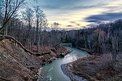
Highland Creek is a neighbourhood in eastern Toronto, Ontario, Canada. It is located along the southern portion of the river of the same name in the former suburb of Scarborough. To the east are the neighbourhoods of Port Union and West Rouge, to the west West Hill and Woburn, and to the south Centennial Scarborough.