Railway Lands

Last updated

The Railway Lands and the Union Station Rail Corridor. The Corridor is the last remaining rail connection in the area. Into the sunset.jpg
The Railway Lands and the Union Station Rail Corridor. The Corridor is the last remaining rail connection in the area.

Railway Lands is an area in Downtown Toronto, Ontario, Canada. Originally a large railway switching yard near the Toronto waterfront, including the CNR Spadina Roundhouse and the CPR John Roundhouse, it has since been redeveloped and today is home to mostly mixed-used development, including the CN Tower and the Rogers Centre. The lands were owned and maintained by the Canadian National Railway and later transferred to the federal crown corporation Canada Lands Company. The area is bounded by Front Street, Yonge Street, Gardiner Expressway and Bathurst Street. [1] The western portion of the Railway Lands is now part of the CityPlace neighbourhood and the eastern portion is now called South Core.

Contents

History

Early history

The Railway Lands between the Toronto waterfront and Front Street, c. 1919. The area saw a build up of rail lines from the 1850s to the 1920s. Toronto from the Air (HS85-10-35813).jpg
The Railway Lands between the Toronto waterfront and Front Street, c. 1919. The area saw a build up of rail lines from the 1850s to the 1920s.

The first railway, Ontario, Simcoe and Huron (OS&H), arrived in Toronto in 1853 with a station located near the current Union Station. Rivals Grand Trunk Railway and Great Western Railway arrived in Toronto to compete with OS&H. The competition placed a strain on the new station and by 1873 a new Union Station was built by the GTR. [2] In the 1880s Grand Trunk Railway acquired rival railways (GWR in 1882 and OS&H in 1888) and the Canadian Pacific Railway arrived in the city in 1888.

The competition soon meant the second station was strained as well and by 1900 there was a need for a newer station. [2] From the 1850s to 1920s the area south of the railway lands were filled in to accommodate railway needs. From 1858 onwards the railway expanded in area as the first Union Station was built. [3] From the 1850s to 1920s, the area south of Front Street was filled in to provide more room for railways, industrial growth and harbour needs. [4]

Toronto's third Union Station nearing its completion, next to the Union Station Rail Corridor, 1927. Constructing Toronto's 3rd Union Station, 1927.jpg
Toronto's third Union Station nearing its completion, next to the Union Station Rail Corridor, 1927.

On July 13, 1906, the Toronto Terminals Railway (TTR) was incorporated to "construct, provide, maintain and operate at the City of Toronto a union passenger station". It was also responsible for the entire 6.4 kilometres (4.0 miles) long railway corridor on either side of the station, between west of Bathurst Street and the Don River, known as the Union Station Rail Corridor (USRC).

The TTR was jointly owned by the Grand Trunk Railway and the Canadian Pacific Railway who each held 50% of the TTR shares. During station construction, the Grand Trunk Railway went bankrupt, was fully nationalized by the Government of Canada, and merged into the Canadian National Railway which would assume the Grand Trunk's 50% ownership of the TTR (and thus the third Union Station). [5]

Union Station was opened on August 6, 1927 by the Prince of Wales, although it was not completed yet. [6] Four days later, the track network was shifted from the former second Union Station. To get to trains, passengers would walk from the south doors to the tracks located several hundred feet to the south while the new USRC viaduct, concourse and train shed was under construction. [7] Demolition of the second Union Station began almost immediately and was completed in 1928. The third Union Station was not fully completed until 1930 when construction of the train shed had finished. [5] The first major change to the Station took place in 1954 when the Toronto Transit Commission opened its Union subway station adjacent to Union Station, buried beneath Front Street.

Redevelopment

1960s–1980s

Construction for the CN Tower in railway lands in 1973. The area was to be redeveloped, with the GTA's rail lines centralized in nearby Vaughan. However, most of these plans were scrapped after the tower's completion. CN Tower footings 1973.jpg
Construction for the CN Tower in railway lands in 1973. The area was to be redeveloped, with the GTA's rail lines centralized in nearby Vaughan. However, most of these plans were scrapped after the tower's completion.

Going as far back as 1965, when Canadian National (CN) began to shift the functions of many of its yards in the Greater Toronto Area to a centralized facility in the northern suburb of Vaughan, the railways lands were made redundant. The yards' layout was also becoming increasingly outdated then. The area was then slated for re-development for post-railway beginning with plans for the building of a communications tower (the CN Tower) and the massive Metro Centre. Two years into the construction of the CN Tower, plans for Metro Centre were scrapped, leaving the tower isolated on the Railway Lands in what was then a largely abandoned light-industrial space. Development of the Railway Lands slowed between the 1970s and 1980. [8] The early 1980s saw more redevelopment, with the opening of the Metro Convention Centre in 1984. The late 1980s saw the building of the SkyDome (for which the CNR Spadina Roundhouse was demolished) and the SkyWalk connecting the SkyDome with Union Station. [9]

1990s–2000s

In the early 1990s redevelopment slowed, but it did see the expansion of the convention centre and the John Street Roundhouse redeveloped into the Roundhouse Park, though it would not be restored until the 2000s. It also saw the redevelopment of the Toronto Postal Building into the Air Canada Centre (since renamed to Scotiabank Arena) in the late 1990s along the eastern boundary of the Railway Lands. [9]

Railway lands west of the CN Tower in 1999. Shortly after the new millennium, the area saw new development that changed the area forever. Looking West from the CN Tower, Toronto, Ontario -- 2008-05-10.jpg
Railway lands west of the CN Tower in 1999. Shortly after the new millennium, the area saw new development that changed the area forever.

In the early 21st Century, the remaining area began to change rapidly with residential and then commercial development changing the area's past use. The western portion of the Railway Lands, defined by the city as Railway Lands West, [1] is today home to the CityPlace neighbourhood built just west of Spadina Avenue, south of Front Street and north of the Gardiner Expressway. Railway Lands Central [1] is mixed use land slightly east of Spadina to the area east of the CN Tower is home to Rogers Centre and CN Tower and parts of CityPlace. Railway Lands East [1] is now the South Core neighbourhood and is a mixed used land slightly east of Rogers Centre and is home to Union Station (and Union Station Bus Terminal), Dominion Public Building, SkyWalk, Metro Toronto Convention Centre, Roundhouse Park, Steam Whistle Brewing, Southcore Financial Centre, Delta Hotel Toronto, CIBC Square, Maple Leaf Square and the aforementioned Scotiabank Arena.

Toronto, Ontario - panoramio.jpg
South Core, Toronto, Ontario (21652181788).jpg
The railway lands were redeveloped in the early 21st century, with its western portion becoming the neighbourhood of CityPlace (left) and its eastern portion South Core (right).

On August 3, 2016, Mayor John Tory announced a proposal to create a Rail Deck Park, decking over the Railway Lands West section to provide additional parkland in Downtown Toronto. The proposed greenspace would comprise 8.3 hectares. [10]

The only remaining rail connection is the Union Station Rail Corridor, which is maintained by Toronto Terminals Railway and consists of the narrow area used by tracks leading into and out of Union Station. The SkyWalk transverses a large part of the former Railway Lands, connecting Union Station with the lands south of the rail corridor.

See also

Related Research Articles

<span class="mw-page-title-main">Union Station (Toronto)</span> Railway station in Toronto, Ontario, Canada

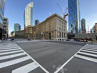
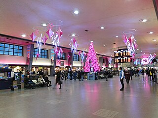
Union Station is a major railway station and intermodal transportation hub in Toronto, Ontario, Canada. It is located on Front Street West, on the south side of the block bounded by Bay Street and York Street in downtown Toronto. The municipal government of Toronto owns the station building while the provincial transit agency Metrolinx owns the train shed and trackage. Union Station has been a National Historic Site of Canada since 1975, and a Heritage Railway Station since 1989. It is operated by the Toronto Terminals Railway, a joint venture of the Canadian National Railway and Canadian Pacific Railway that directs and controls train movement along the Union Station Rail Corridor, the largest and busiest rail corridor in Canada.

<span class="mw-page-title-main">Harbourfront, Toronto</span> Neighbourhood in Toronto, Ontario, Canada

Harbourfront is a neighbourhood on the northern shore of Lake Ontario within the downtown core of the city of Toronto, Ontario, Canada. Part of the Toronto waterfront, Harbourfront extends from Bathurst Street in the west, along Queens Quay, with its ill-defined eastern boundary being either Yonge Street or York Street. Its northern boundary is the Gardiner Expressway. Much of the district was former water lots filled in during the early 1900s to create a larger harbour district. After shipping patterns changed and the use of the Toronto harbour declined, the area was converted from industrial uses to a mixed-use district that is mostly residential and leisure.

<span class="mw-page-title-main">Toronto waterfront</span> Shore of Lake Ontario in Toronto, Canada

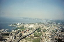
The Toronto waterfront is the lakeshore of Lake Ontario in the city of Toronto, Ontario, Canada. It spans 46 kilometres between the mouth of Etobicoke Creek in the west and the Rouge River in the east.

<span class="mw-page-title-main">Spadina Avenue</span> Thoroughfare in Toronto, Ontario

Spadina Avenue is one of the most prominent streets in Toronto, Ontario, Canada. Running through the western section of downtown, the road has a very different character in different neighbourhoods.
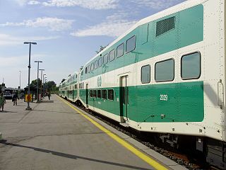
<span class="mw-page-title-main">Metro Toronto Convention Centre</span>

Metro Toronto Convention Centre, is a convention complex located in Toronto, Ontario, Canada along Front Street West in the former Railway Lands in downtown Toronto. The property is today owned by Oxford Properties. The centre is operated by the Metropolitan Toronto Convention Centre Corporation, an independent agency of the Government of Ontario.

<span class="mw-page-title-main">Front Street (Toronto)</span> Thoroughfare in Toronto, Ontario

Front Street is an east–west road in downtown Toronto, Ontario, Canada. First laid out in 1796, the street is one of the original streets of the Town of York. The street was laid out along the shoreline of Lake Ontario as it existed during that time. It remains an important street, with many important uses located along it, including the St. Lawrence Market, Meridian Hall, Union Station and the Metro Toronto Convention Centre. The eastern section of Front Street, in the West Don Lands, east of Cherry Street, is being rebuilt as a broad tree-lined boulevard, intended to be the pedestrian-friendly commercial spine of the new neighbourhood.

<span class="mw-page-title-main">Montreal Central Station</span> Railway station in Montreal, Canada

Montreal Central Station is the major inter-city rail station and a major commuter rail hub in Montreal, Quebec, Canada. Nearly 11 million rail passengers use the station every year, making it the second-busiest train station in Canada, after Toronto Union Station.

<span class="mw-page-title-main">London station (Ontario)</span> Intercity train station in London, Ontario

London station in London, Ontario, Canada is a major interchange for Via Rail trains running from Toronto west to Sarnia and Windsor. The station is a large, modern, wheelchair accessible building on the south end of the city centre, and connects to local public transit bus services.

<span class="mw-page-title-main">CNR Spadina Roundhouse</span>

The CNR Spadina Roundhouse was owned by the Canadian National Railway, built in 1928. The purpose of Spadina Roundhouse was the pretrip inspection, service and repairing of the motive power of passenger trains, including locomotives and Budd Rail Diesel Cars terminating, or originating at Toronto Union Station.

<span class="mw-page-title-main">CityPlace, Toronto</span> Neighbourhood in Ontario, Canada

CityPlace is a neighbourhood in Downtown Toronto, Ontario, Canada, within the former Railway Lands. When completed, this area will be the largest residential development ever created in Toronto. The area is bordered by Bathurst Street to the west, Lake Shore Boulevard to the south, and Front Street to the north and Blue Jays Way and Rogers Centre to the east. Cityplace is also a five-to-ten-minute walk from King Street West and Liberty Village and a ten-to-twenty-minute walk from Toronto's financial district. The neighbourhood is also home to the Canoe Landing Park, designed by famed Canadian writer and artist Douglas Coupland.

<span class="mw-page-title-main">John Street (Toronto)</span> Street in Toronto, Ontario, Canada

John Street is a street in Downtown Toronto. It runs from Stephanie Street and Grange Park in the north to the Metro Toronto Convention Centre on Front Street in the south. It is home to a number of Toronto's cultural institutions, including buildings for the CBC, CTV, Toronto International Film Festival. The National Post has described it as "Running directly through the entertainment district, its spine connects many great cultural institutions, popular retail outlets, restaurants and soon-to-be-built condos." The City of Toronto has dubbed the street a "Cultural Corridor" and a report calls it "the centrepiece of the Entertainment District."

<span class="mw-page-title-main">Downtown Toronto</span> Central business district in Toronto, Ontario, Canada

Downtown Toronto is the main central business district of Toronto, Ontario, Canada. Located entirely within the district of Old Toronto, it is approximately 16.6 square kilometres in area, bounded by Bloor Street to the northeast and Dupont Street to the northwest, Lake Ontario to the south, the Don Valley to the east, and Bathurst Street to the west. It is also the home of the municipal government of Toronto and the Government of Ontario.
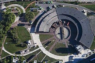
<span class="mw-page-title-main">Roundhouse Park</span> Park in Toronto, Ontario, Canada

Roundhouse Park is a 17 acre park in the downtown core of Toronto, Ontario, Canada. It is in the former Railway Lands. It features the John Street Roundhouse, a preserved locomotive roundhouse which is home to the Toronto Railway Museum, Steam Whistle Brewing, and the restaurant and entertainment complex The Rec Room. The park is also home to a collection of trains, the former Canadian Pacific Railway Don Station, and the Roundhouse Park Miniature Railway. The park is bounded by Bremner Boulevard, Lower Simcoe Street, Lake Shore Boulevard West/Gardiner Expressway and Rees Street.

The Old Canadian National rail yard in Edmonton was once the centre of economic activity in that city. Its redevelopment has fundamentally altered the appearance of the city. The former yard occupied a long, narrow strip from 103 Avenue to 105 Avenue north to south and from 101 Street to 116 Street east and west.

<span class="mw-page-title-main">SkyWalk</span> Bridge in Ontario, Canada

The SkyWalk is an approximately 160 metre enclosed walkway connecting Union Station to the CN Tower and the Rogers Centre (SkyDome) in Toronto, Ontario, Canada. Part of Toronto's PATH network, the SkyWalk passes above the York Street 'subway' and the Simcoe Street Tunnel and runs roughly parallel between Front Street and Bremner Boulevard.

<span class="mw-page-title-main">Riverdale station (Toronto)</span> Railway station in Toronto, Ontario, Canada

Riverdale Railway Station was located on De Grassi Street just north of Queen Street East in Toronto, Ontario, Canada. Constructed by the Grand Trunk Railway (GTR) in 1896 as "Queen East Station", on what is now the Lakeshore East line, the station was renamed "Riverdale Station" in 1907. The Canadian National Railway (CNR) took over the station in 1923, when they absorbed the Grand Trunk Railway. CNR discontinued passenger train service at the station in 1932, later for commercial use and demolished the building in 1974.

<span class="mw-page-title-main">Via Toronto Maintenance Centre</span> Canadian passenger rail yard

Via Rail's Toronto Maintenance Centre is a railway yard in the western end of Toronto, which stores and services Via trains. It lies within the south side of the former Canadian National Mimico Yard directly opposite of the Willowbrook Rail Maintenance Facility on the north side; GO Transit's Lakeshore West line separates the two facilities. The yard is bisected by the Islington Avenue flyover bridge. Its main entrance is located at 50 Drummond Street on the eastern side with a secondary entrance on its southern side along New Toronto Street at Eighth Street.

<span class="mw-page-title-main">The Esplanade (Toronto)</span> East-west street in Toronto, Canada

The Esplanade is an east-west street along the central waterfront of Toronto, Ontario, Canada. This neighbourhood consists of generally low-rise and mid-rise housing - condominiums, public housing, cooperatives and some town homes between Jarvis and Parliament Streets south of Front Street. The stretch between Scott Street and Market Street is a popular restaurant area.

<span class="mw-page-title-main">Union Station Rail Corridor</span> Rail corridor in Toronto, Ontario

The Union Station Rail Corridor (USRC) is a corridor of railway tracks that exist through and adjacent to Union Station in downtown Toronto. It is 6.4 kilometres long, approximately stretching from Bathurst Street in the west to the Don River in the east, making it the largest rail passenger facility in Canada.

Rail Deck Park is a proposed large urban park in Downtown, Toronto, Ontario, Canada. Announced on August 3, 2016, the park will be set on a constructed deck that encloses the active Railway Lands between Bathurst Street and Blue Jays Way, west of the Rogers Centre. In total, the park will span 8.5 hectares when constructed. As of November 2017, the City of Toronto estimated the park to cost $1.66 billion. In May 2020, the Canadian Taxpayers Federation released a study saying that once exclusions from the city's estimates are factored in the park would cost more than $3.7 billion.

References

  1. 1 2 3 4 http://www.toronto.ca/planning/urbdesign/pdf/29railwaylands_wescen_pt1.pdf City of Toronto Area Studies Map
  2. 1 2 Toronto Railway Historical Association. Trha.ca (1927-08-10). Retrieved on 2013-07-26.
  3. Toronto Railway Historical Association. Trha.ca. Retrieved on 2013-07-26.
  4. City of Toronto, History Resources. Toronto.ca (2000-10-23). Retrieved on 2013-07-26.
  5. 1 2 Toronto Terminals Railway (November 2007). "Toronto Terminals Railway history". Archived from the original on 23 October 2007. Retrieved 24 November 2007.
  6. Riddell, John (1991). The Railways of Toronto: The First Hundred Years. Vol. Two. British Railway Modellers of North America. p. 14. ISBN   9780919487475.
  7. Riddell 1991, p. 14.
  8. A visual history of the Toronto Railway Lands. Blogto.com (2011-11-03). Retrieved on July 26, 2013.
  9. 1 2 "The history of the Toronto railway lands before South Core and CityPlace".
  10. Simmons, Taylor (August 3, 2016). "Massive downtown #RailDeckPark will cover railway tracks from Rogers Centre to Bathurst". CBC News. Retrieved November 11, 2016.

43°38′41″N79°22′51″W / 43.644662°N 79.380770°W / 43.644662; -79.380770