Malvern, Toronto

Last updated

Malvern
Neighbourhood
Malvern in Toronto 2023.jpg
Aerial view of Malvern in 2023
Malvern, Toronto
Location of Malvern in Toronto
Coordinates: 43°48′42″N79°13′52″W / 43.81167°N 79.23111°W / 43.81167; -79.23111 [1]
CountryCanada
Province Ontario
City Toronto
Established1850 Scarborough Township
Village established1856 (Postal village)
Changed municipality1998 Toronto from City of Scarborough
Government
   MP Gary Anandasangaree (L)
Shaun Chen (L)
   MPP Raymond Cho (C)
   Councillor Neethan Shan

Malvern is a neighbourhood in the city of Toronto, Ontario, Canada, with a population of 44,315. [3] It is located in the northeast corner of the city.

Contents

There are over 60 different cultures represented in Malvern, with the most dominant ethnic groups being Caribbean Canadians (mostly Jamaican, Trinidadian, and Guyanese) and South Asian Canadians (mostly Sri Lankan Tamil, Indian, and Pakistani). The neighbourhood has the highest concentration of young people in Canada. [4]

History

Elderslie House, built in 1864. Malvern was first settled in the mid-1850s. Elderslie.JPG
Elderslie House, built in 1864. Malvern was first settled in the mid-1850s.

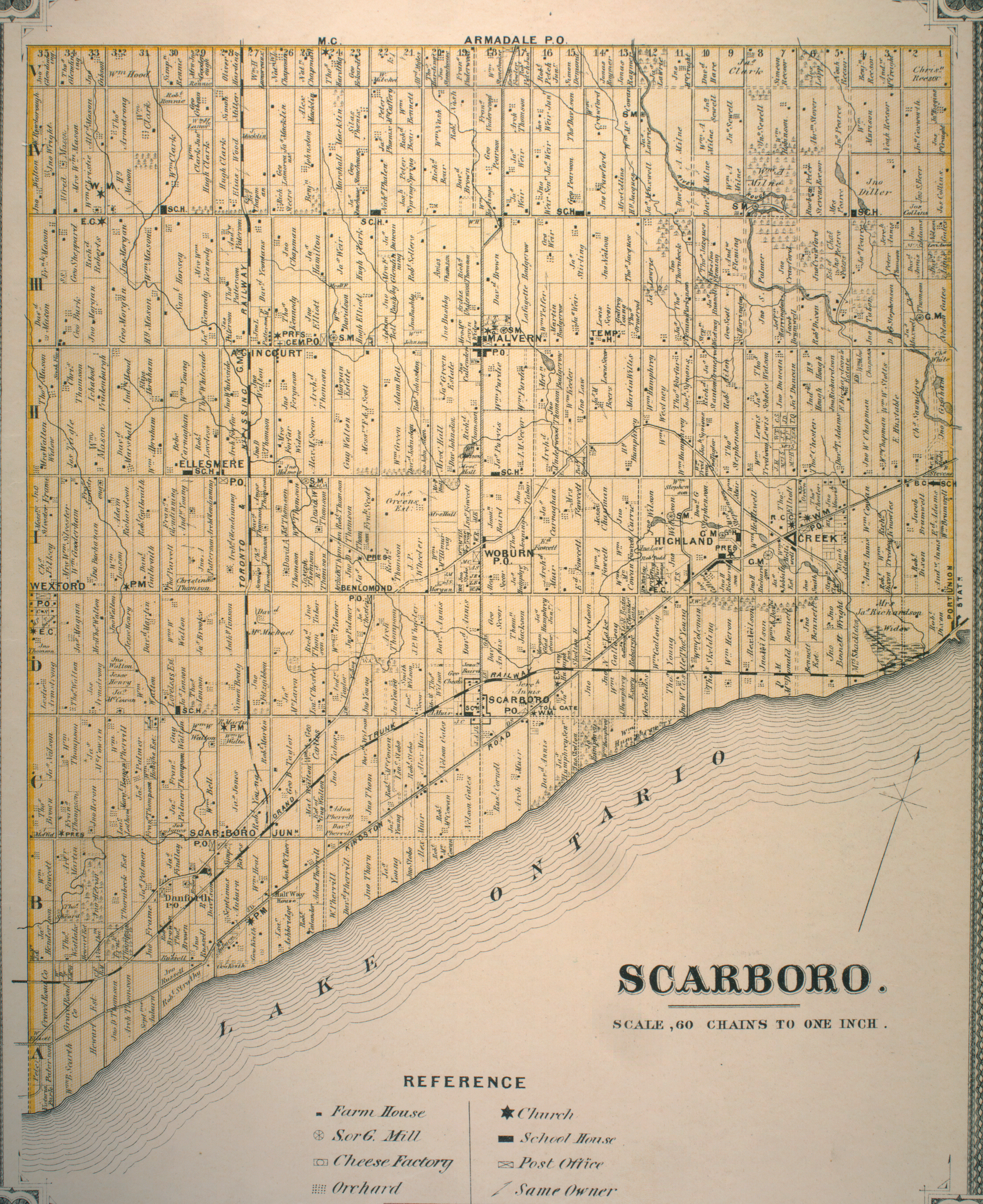
The history of Malvern began in 1856, when the Malvern Post Office was opened in David Brown's general store, which stood at the south-east corner of Finch Avenue and Markham Road. This post office was named after a resort town in England. A year after the post office was opened, Senator David Reesor  — formerly of Markham Village — began selling "Village Lots" in Malvern. Reesor trumpeted Malvern as the future "Capital of Scarborough," anticipating that the Grand Trunk Railway would extend a branch line through here. However, when the Grand Trunk Railway began service to this area in 1871, it bypassed Malvern in favour of the neighbouring village of Agincourt. The village centre and post office had by that time moved south to the corner of today's Sheppard Avenue and Markham Road, [5] which was named Malcolm's Corners at the time. The Malvern Primitive Methodist Church on the east side of Markham Road north of Sheppard disappeared in the 1970s, but the graves remain today in the care of the Toronto United Church Council.

While Malvern never did become a prosperous railway centre, it flourished as a farming community for over one hundred years. In the late 1950s, the Canada Mortgage and Housing Corporation expropriated Malvern's farms to build a "model community" of affordable homes. The first residents of this modern day Malvern community moved into their homes in 1972.

The Malvern community has attempted to improve following Project Impact, in which hundreds of police officers from the Greater Toronto Area cracked down on known associates of the "Malvern Crew" street gang, in early morning raids across the city on May 12, 2004. During the raids, 71 warrants were executed resulting in the arrest of 65 people. [6] Further raids, and the implementation of Project Pathfinder would result in arrests of the Malvern Crew's rival gang, the "Galloway Boys", in West Hill.

The Malvern branch of the Toronto Public Library was renovated in 2003. Toronto Public Library - Malvern Branch interior 2023.jpg
The Malvern branch of the Toronto Public Library was renovated in 2003.

In the early 21st century, the area saw public investment in the community, including a major renovation of the Malvern Branch of the Toronto Public Library, the construction of new housing developments, the opening of a new park in 2004, and the opening of the Nike Malvern Sports Complex in 2006. The Toronto Zoo, Rouge River, and Rouge Valley Park are also located in the vicinity of Malvern, as was Mammoth Hall, a wooden structure that was once a municipal office, meeting hall and curling rink. The Malvern Community Coalition serves as an active incorporated, non-profit, grassroots community organization which exists to promote and enhance the Malvern Community by engaging, empowering, and connecting community, organizations and institutions. [7]

Education

Lester B. Pearson Collegiate Institute is one of two secondary schools in Malvern. Lester B. Pearson Collegiate Institute.JPG
Lester B. Pearson Collegiate Institute is one of two secondary schools in Malvern.
Berner Trail Junior Public School Berner Trail Junior Public School 2023.jpg
Berner Trail Junior Public School

Two public school boards operate schools in Malvern, the separate Toronto Catholic District School Board (TCDSB), and the secular Toronto District School Board (TDSB).

Both TCDSB and TDSB operate one public secondary school in the neighbourhood. TCDSB operates St. Mother Teresa Catholic Academy, while TDSB operates Lester B. Pearson Collegiate Institute. In addition to secondary schools, both school boards operate several public elementary schools in the Malvern. They include:

The French-first language public secular school board, Conseil scolaire Viamonde, and it separate counterpart, Conseil scolaire catholique MonAvenir also offer schooling to applicable residents of Malvern, although they do not operate a school in the neighbourhood, with CSCM/CSV students attending schools situated in other neighbourhoods in Toronto.

The former S.S. #3 Schoolhouse, serving the Malvern area, built in 1872 stood on 1-acre (4,000 m2) of land purchased from George Pearson, [5] is still standing today at 5810 Finch Avenue East. The building is presently used by a private school, Whitefield Christian Academy.

Transportation

Sewells Road Bridge, in northeast Malvern Bridge over the Rouge River on Sewell's Road 2.jpg
Sewells Road Bridge, in northeast Malvern

Several major roadways are located in Malvern. The neighbourhood is bounded to the south by Highway 401 is a major east-west controlled access highway that passes through Greater Toronto. Several other major roadways include Morningside Avenue and Sheppard Avenue. Located on Sewells Road, the Sewells Road Bridge is a bridge over the Rouge River, in the northeast of Malvern.

Public transit

Malvern is served by several Toronto Transit Commission (TTC) bus routes (39 Finch East, 85 Sheppard East, 102 Markham Rd, 116 Morningside, 131 Nugget, 132 Milner, 133 Neilson, 134 Progress, 902 Markham Rd Express, 939C Finch Express, and 985B Sheppard East Express). In the 1980s, there was a plan to bring rapid transit to Malvern by extending the Scarborough line, but lack of government funding prevented any extension of the line. In August 2006, city councillors representing Scarborough rallied for the expansion of the Scarborough line, or its possible light rail replacement, to the Malvern community.

Scarborough line extension to Malvern

Back in 2012, the TTC considered carrying assessing extending the RT from McCowan to Malvern Town Centre. [8] They have also made a motion that the current study should include the addition of a station where the existing line crosses Brimley Road. [9] The proposal is moot now as Line 3 Scarborough RT is scheduled to be torn down and replaced by the extension of Line 2 Bloor–Danforth.

In 2006, a study was completed on the prospects of this line. [10] It recommended upgrading the line to handle larger ART Mark II vehicles, at a cost of $360 million (2006 dollars). Extending the Bloor–Danforth line (either along the current Scarborough RT route, or along a different alignment directly to Scarborough Centre) was not considered cost-effective or justifiable.

On June 15, 2007, the Ontario government had released MoveOntario 2020, a plan that would fund 52 different transit projects throughout Toronto and Hamilton for the cost of $17.5 billion, including the Scarborough RT extension to Sheppard Avenue, which would meet the proposed Sheppard East LRT line, also to be funded by MoveOntario 2020. Unfortunately, in a 2010 budget release, Ontario Premier Dalton McGuinty had chosen to postpone necessary funding for the project.

With the construction of Line 5 Eglinton nearing its end, there have been discussions and studies about either extending this LRT line or constructing a brand new LRT line to Malvern via University of Toronto Scarborough Campus. [11] In May 2023, the city decided to plan a stand-alone light-rail line running from Kennedy station to Malvern via Eglinton Avenue, Kingston Road, Morningside Avenue and Sheppard Avenue. The new line, dubbed the Eglinton East LRT, would mostly follow the route of the previously proposed but cancelled Scarborough Malvern LRT. [12]

Scarborough Malvern LRT

The Scarborough Malvern LRT line, part of the TTC's Transit City plan, would run for 15 km, estimated to account for 14 million trips in 2021. The southern terminus of the line would be built at Kennedy Station at Kennedy Road and Eglinton Avenue, with a connection to the Bloor-Danforth subway, the Scarborough RT, and the Eglinton Crosstown LRT line. The whole line would be built within Scarborough. The line would run along Eglinton Avenue East until it reaches Kingston Road, then continues northeast until Morningside Avenue is reached, then continues north until Sheppard Avenue East, where it turns west, sharing the same tracks and stops as in the Sheppard East LRT line. Finally, the line turns north at Neilson Road, terminating at Malvern Town Centre.

Newly elected Rob Ford cancelled the Malvern LRT shortly after he came to office in 2010. [13] [14]

The Malvern LRT would cross the University of Toronto Scarborough Campus. [14] According to The Varsity , the paper for students at the University of Toronto, when students at the Scarborough campus were asked to contribute $30 million towards the construction of an Olympic class pool on their campus, which would first be used for competitions during the 2015 Pan American Games, they were promised two LRT lines would be brought to campus. The Varsity reported that the students had held up their part of the bargain and resented that the city dropped plans to build the LRT lines.

In May 2023, the city decided to resurrect the Scarborough Malvern LRT proposal but renaming it the Eglinton East LRT. [12]

Sheppard East RT

Metrolinx is looking into an extension of Line 4 Sheppard to Meadowvale Road along Sheppard Avenue East. This extension would run through southern Malvern. [15]

Economy

Malvern Town Centre

Malvern Town Centre interior, 2023 Malvern Town Centre interior 2023.jpg
Malvern Town Centre interior, 2023

Although Scarborough Town Centre is a short drive away, Malvern Town Centre provides some retail options and amenities to local residents. Built in the late 1980s, the mall's primary tenants are Freshland Supermarket, an Asian grocery store; Planet Fitness; and Labels, a discount clothing store. There are plans in the works to redevelop the mall and replace it with residential condo towers and green space. The proposed plan would include a new 16,616 square-metre public park immediately abutting the existing forested area. [16]

Demographics

In 2016, the Malvern neighbourhood was home to 43,794 residents. [17] 51% of the population spoke English as their first language, 12.5% spoke Tamil, 6% spoke Tagalog, 5% spoke Urdu, 3.9% spoke Cantonese and 3.6% spoke Gujarati.

Major ethnic populations (2016):

Climate

Climate data is from Buttonville Municipal Airport located 12.48 km (7.75 mi) west.

Climate data for Markham (Buttonville at Toronto Buttonville Airport)
WMO ID: 71639; coordinates 43°51′44″N79°22′12″W / 43.86222°N 79.37000°W / 43.86222; -79.37000 (Toronto Buttonville Airport) ; elevation: 198.1 m (650 ft); 1981–2010 normals
MonthJanFebMarAprMayJunJulAugSepOctNovDecYear
Record high humidex 16.014.429.235.741.044.650.947.443.637.824.920.650.9
Record high °C (°F)14.9
(58.8)
14.9
(58.8)
26.0
(78.8)
31.7
(89.1)
34.6
(94.3)
36.6
(97.9)
37.2
(99.0)
37.8
(100.0)
34.4
(93.9)
31.0
(87.8)
22.1
(71.8)
18.0
(64.4)
37.8
(100.0)
Mean daily maximum °C (°F)−1.5
(29.3)
−0.9
(30.4)
4.5
(40.1)
12.1
(53.8)
19.1
(66.4)
24.6
(76.3)
27.1
(80.8)
26.0
(78.8)
21.5
(70.7)
14.1
(57.4)
7.2
(45.0)
0.9
(33.6)
12.9
(55.2)
Daily mean °C (°F)−5.8
(21.6)
−5.6
(21.9)
−0.4
(31.3)
6.7
(44.1)
13.0
(55.4)
18.6
(65.5)
21.2
(70.2)
20.2
(68.4)
15.7
(60.3)
8.9
(48.0)
3.1
(37.6)
−2.9
(26.8)
7.7
(45.9)
Mean daily minimum °C (°F)−10.1
(13.8)
−10.2
(13.6)
−5.3
(22.5)
1.2
(34.2)
6.8
(44.2)
12.6
(54.7)
15.2
(59.4)
14.3
(57.7)
9.9
(49.8)
3.6
(38.5)
−1.1
(30.0)
−6.8
(19.8)
2.5
(36.5)
Record low °C (°F)−35.2
(−31.4)
−25.7
(−14.3)
−25.6
(−14.1)
−10.1
(13.8)
−2.1
(28.2)
1.9
(35.4)
6.9
(44.4)
4.2
(39.6)
−2.0
(28.4)
−7.4
(18.7)
−15.0
(5.0)
−26.0
(−14.8)
−35.2
(−31.4)
Record low wind chill −42.6−37.4−35.6−18.6−4.40.00.00.0−4.2−8.8−23.9−36.6−42.6
Average precipitation mm (inches)62.1
(2.44)
50.5
(1.99)
53.2
(2.09)
74.1
(2.92)
79.6
(3.13)
82.8
(3.26)
79.0
(3.11)
76.2
(3.00)
81.8
(3.22)
68.0
(2.68)
80.0
(3.15)
65.7
(2.59)
852.9
(33.58)
Average rainfall mm (inches)26.0
(1.02)
22.9
(0.90)
33.6
(1.32)
66.7
(2.63)
79.5
(3.13)
82.8
(3.26)
78.8
(3.10)
76.2
(3.00)
81.8
(3.22)
66.7
(2.63)
68.3
(2.69)
34.2
(1.35)
717.4
(28.24)
Average snowfall cm (inches)38.9
(15.3)
29.9
(11.8)
19.3
(7.6)
7.5
(3.0)
0.1
(0.0)
0.0
(0.0)
0.0
(0.0)
0.0
(0.0)
0.0
(0.0)
0.6
(0.2)
12.1
(4.8)
34.2
(13.5)
142.6
(56.1)
Average precipitation days (≥ 0.2 mm)16.712.912.012.312.011.811.29.910.813.214.515.3152.7
Average rainy days (≥ 0.2 mm)5.83.86.710.812.011.811.29.910.813.011.36.6113.7
Average snowy days (≥ 0.2 cm)13.410.87.02.90.130.00.00.00.00.484.710.850.2
Average relative humidity (%) (at 1500 LST)69.664.057.852.952.353.953.455.959.262.468.971.160.1
Source: Environment and Climate Change Canada [18]

Notable residents

Related Research Articles

<span class="mw-page-title-main">Agincourt, Toronto</span> Neighbourhood in Toronto, Ontario, Canada

Agincourt is a neighbourhood and former village in Toronto, Ontario, Canada. Agincourt is located in northeast Toronto, along Sheppard Avenue between Kennedy and Markham Roads. Before the creation of the "megacity" of Toronto in 1998, the area was part of Scarborough. It is officially recognized by the City of Toronto as occupying the neighbourhoods of Agincourt South–Malvern West and Agincourt North.

<span class="mw-page-title-main">West Hill, Toronto</span> Neighbourhood in Toronto, Ontario, Canada

West Hill is a neighbourhood in Toronto, Ontario, Canada. It is located in the eastern end of the city, in the former suburb of Scarborough. It is roughly bounded by Scarborough Golf Club Road and a branch of Highland Creek on the west, the CNR railway tracks and Lake Ontario on the south, and Highland Creek on the north-east. The name comes from its elevated position on the west side of Highland Creek, a deep glacial ravine.

<span class="mw-page-title-main">Willowdale, Toronto</span> Neighbourhood in Toronto, Ontario, Canada

Willowdale is a neighbourhood in the city of Toronto, Ontario, Canada, located in the district of North York. It developed from three postal villages: Newtonbrook, Willowdale and Lansing.

<span class="mw-page-title-main">Scarborough Village</span> Neighbourhood in Toronto, Ontario, Canada

Scarborough Village is a neighbourhood in Toronto, Ontario, Canada, located in the Scarborough district. It was one of the earliest settlements in the former township of Scarborough with the distinction of being the site of the township's first post office. Today, the neighbourhood is composed of private and public housing, apartment complexes, schools, a few condominiums, and strip mall plazas. The neighbourhood lies along the Scarborough Bluffs escarpment.

<span class="mw-page-title-main">Brimley Road</span> Thoroughfare in Toronto, Ontario

Brimley Road is a north-south street in Toronto and the Regional Municipality of York, Ontario, Canada. In Toronto, it is located entirely within Scarborough and carried 32000 vehicles daily in May 2007 Hence, it is classified as a major arterial road by the city of Toronto.

<span class="mw-page-title-main">Richview, Toronto</span> Neighbourhood in Toronto, Ontario, Canada

Richview, formally known as Willowridge-Martingrove-Richview, is a neighbourhood in the city of Toronto, Ontario, Canada. It is bounded on the west by Highway 401 and on the north by the highway and by Dixon Road, Royal York Road on the east, and Eglinton Avenue West along the south. Richview was originally established as a postal village within the then-agricultural Etobicoke Township, which later became the suburb of Etobicoke.

<span class="mw-page-title-main">York University Heights</span> Neighbourhood in Toronto, Ontario, Canada

York University Heights, also known as Northwood Park, is a neighbourhood in Toronto, Ontario, Canada. It is one of Toronto's northernmost neighbourhoods, located along the northern boundary of Steeles Avenue in the former city of North York. The neighbourhood is so named because it contains the main campus of York University. This area is most popular with immigrants of Italian and Chinese descent who have established communities in the area. It is located between Sheppard Avenue and Steeles Avenue east of Black Creek.

<span class="mw-page-title-main">Lawrence Manor</span> Neighbourhood in Toronto, Ontario, Canada

Lawrence Manor is a neighbourhood in the city of Toronto, Ontario, Canada. This neighbourhood is bounded by Bathurst Street on the east, Highway 401 to the north, the Allen to the west, and Lawrence Avenue to the south. The western side of the area borders along Bathurst Heights and the large public housing project.

<span class="mw-page-title-main">Clanton Park, Toronto</span> Neighbourhood in Toronto, Ontario, Canada

Clanton Park is a neighbourhood in Toronto, Ontario, Canada. Located in the district of North York, it is part of federal and provincial electoral district York Centre, and Toronto electoral wards 9: York Centre (West) and 10: York Centre (East). In 2016, it had a population of 16,472, a 12.7% rise from 2011.

<span class="mw-page-title-main">Pleasant View, Toronto</span> Neighbourhood in Toronto, Ontario, Canada

Pleasant View is a neighbourhood in the city of Toronto, Ontario, Canada that is located in the district of North York at the northern end of the city. It is bordered by Victoria Park to the East, Sheppard Avenue to the South, Highway 404 to the west and the Finch hydro corridor to the north. The neighbourhood is home to several high-rise apartment and condominium buildings, such as The Clippers.

<span class="mw-page-title-main">Don Valley Village</span> Neighbourhood in Toronto, Ontario, Canada

Don Valley Village is a neighbourhood in the city of Toronto, Ontario, Canada. It is located in the former suburb of North York. Located north of Highway 401 and bisected by Don Mills Road, it is bounded by Sheppard Avenue to the south, Leslie Street to the west, Finch Avenue to the north and Highway 404 to the east. Like the nearby Don River Valley, the neighbourhood has hill and dale topography.

<span class="mw-page-title-main">Steeles, Toronto</span> Neighbourhood in Toronto, Ontario, Canada

Steeles is a suburban neighbourhood in Toronto, Ontario, Canada. Steeles is located in the north-eastern part of Toronto in the former suburb of Scarborough. To the north is bordered by Steeles Avenue East, to the east by Kennedy Road, to the south by a hydro-electric transmission line and to the west by Victoria Park Avenue.

<span class="mw-page-title-main">Clairlea</span> Neighbourhood in Toronto, Ontario, Canada

Clairlea is a safe, quiet, middle to upper-middle income neighbourhood in Toronto, Ontario, Canada that features well treed streets and detached homes with large backyards. The neighbourhood is located in east Toronto just east of Victoria Park Avenue.

<span class="mw-page-title-main">Woburn, Toronto</span> Neighbourhood in Toronto, Ontario, Canada

Woburn is a neighbourhood located in eastern Toronto, Ontario, Canada, in the former suburb of Scarborough. Woburn is bordered by Highway 401 to the north, Orton Park Road to the east, Lawrence Avenue to the south, and McCowan Road to the west.

<span class="mw-page-title-main">Eglinton East</span> Neighbourhood in Toronto, Ontario, Canada

Eglinton East, historically known as Knob Hill, is a residential and commercial neighbourhood in Toronto, Ontario, Canada. It is bounded by Stansbury Crescent, Citadel Drive, and West Highland Creek to the north, Midland Avenue to the west, the CNR rail line, Brimley Road, and Eglinton Avenue to the south, and Bellamy Road North to the east.

<span class="mw-page-title-main">Morningside Heights, Toronto</span> Neighbourhood in Toronto, Ontario, Canada

Morningside Heights is a residential neighbourhood in Toronto, Ontario, Canada. It is located in the northeast corner of the city, in the district of Scarborough, just north of the neighbourhood of Malvern and west of Rouge Park and the Rouge. The subdivision, comprising approximately 750 acres (3.0 km2), was one of the last large tracts of undeveloped land within the City of Toronto, located between Finch Avenue East and Steeles Avenue East, from Tapscott Road to the Rouge River.

<span class="mw-page-title-main">Transit City</span> Proposed Toronto public transit plan

Transit City was a plan for developing public transport in Toronto, Ontario, Canada. It was first proposed and announced on 16 March 2007 by Toronto mayor David Miller and Toronto Transit Commission (TTC) chair Adam Giambrone. The plan called for the construction of seven new light rail lines along the streets of seven priority transit corridors, which would have eventually been integrated with existing rapid transit, streetcar, and bus routes. Other transit improvements outlined in the plan included upgrading and extending the Scarborough RT line, implementing new bus rapid transit lines, and improving frequency and timing of 21 key bus routes. The plan integrated public transportation objectives outlined in the City of Toronto Official Plan, the TTC Ridership Growth Strategy and Miller's 2006 election platform.

The Sheppard East LRT was a proposed light rail line in Toronto, Ontario, Canada. It was first announced as part of the Transit City proposal in 2007. The Sheppard East LRT as proposed was to be 13 kilometres (8.1 mi) long, travel along Sheppard Avenue from Don Mills subway station to east of Morningside Avenue, and be operated by the Toronto Transit Commission (TTC).

The Eglinton East LRT (EELRT), also known as Line 7 Eglinton East and formerly known as the Scarborough Malvern LRT, is a proposed light rail line in Toronto, Ontario, Canada. The line would be entirely within the district of Scarborough. It was originally part of Transit City, a plan to develop new light rail lines along several priority transit corridors in the city.

<span class="mw-page-title-main">Highland Creek, Toronto</span> Neighbourhood in Toronto, Ontario, Canada

Highland Creek is a neighbourhood in eastern Toronto, Ontario, Canada. It is located along the southern portion of the river of the same name in the former suburb of Scarborough. To the east are the neighbourhoods of Port Union and West Rouge, to the west West Hill and Woburn, and to the south Centennial Scarborough.

References

  1. "Malvern". Geographical Names Data Base . Natural Resources Canada . Retrieved 2010-07-15.
  2. "Malvern". Geographical Names Data Base . Natural Resources Canada . Retrieved 2010-07-15.
  3. Malvern (132) - Social Profile #1 - Neighbourhoods - Age & Gender City of Toronto (2007). Retrieved on 2009-01-08.
  4. CANOE – The Toronto Sun CareerConnection – Youth Force [usurped]
  5. 1 2 "Township of Scarboro" (JPG). Canadian County Atlas Project. McGill University. 2001. Retrieved 2010-07-15. Emblem-important-yellow.svg 11 MB.
  6. "Toronto police arrest 65 alleged gang members". CBC.ca . 13 May 2004. Retrieved 8 February 2011.
  7. MCC - What's Up in Malvern Archived 2007-10-08 at the Wayback Machine
  8. "Proposed Extension of the Scarborough Rapid Transit (SRT)". Archived from the original on 2012-10-06. Retrieved 2008-03-30.
  9. "TTC Minutes — February 27, 2008" (PDF). Retrieved 2008-03-30.
  10. "Scarborough RT Strategic Plan – Study Report — Final Report — August 2006" (PDF). Retrieved 2008-03-30.
  11. "Advancing City Priority Transit Expansion Projects – Eglinton East LRT and Waterfront East LRT" (PDF). City of Toronto. May 25, 2022. Archived (PDF) from the original on June 1, 2022.
  12. 1 2 City of Toronto; Toronto Transit Commission (May 2023). Eglinton East Light Rail Transit (EELRT)–Functional (10%) Design Phase (PDF). Archived (PDF) from the original on 18 May 2023. Retrieved 18 May 2023.
  13. "Mayor Rob Ford: "Transit City is over"". Toronto Life. 2010-12-01. Archived from the original on 2010-12-04. Retrieved 2014-03-17. Rob Ford's first few hours as mayor sure have been busy. As the dailies are reporting, Ford met with TTC chief general manager Gary Webster at seven this morning to let him know that Transit City, and its attendant "war on the car," were kaput. "I just wanted to make it quite clear that he understood that Transit City's over and the war on the car is over, and all new subway expansion is going underground," Ford said, according to the Sun. "And that's pretty well it."
  14. 1 2 Alessandra Harkness; Gabriela Ansari-Correa; Marcus Tutert (2014-03-17). "Questions remain on LRT lines through Scarborough: UTSC administration hopeful that issue will be resolved after municipal elections". The Varsity. Archived from the original on 2014-03-17. UTSC students held a campus-wide vote on whether to contribute a portion of the cost of the Olympic-sized pool for the Pan Am Games. Although not a direct LRT vote, students thought that building for Pan Am would allow for the construction of the LRT. This resulted in a commitment from students to contribute $30 million towards the building of the Pan Am/Parapan Am Games facility, which are being built on UTSC property. According to Arale, the main reason for the contribution was to get the two LRT lines to run through campus. Students have held to their commitment and blame Toronto city councillors and administration for not holding up their end of the deal.
  15. "Metrolinx - Sheppard Extension". www.metrolinx.com. Retrieved 2023-11-05.
  16. "Another Toronto mall will be completely demolished to make way for condos".
  17. "Malvern neighbourhood profile" (PDF). City of Toronto. Retrieved 2018-11-21.
  18. "Toronto Buttonville Airport". Canadian Climate Normals 1981−2010. Environment and Climate Change Canada. Retrieved 2014-04-12.