Humber Valley Village

Last updated

Humber Valley Village
Neighbourhood
Humber Valley Village house.JPG
Humber Valley Village map.png
Coordinates: 43°40′18″N79°30′52″W / 43.67167°N 79.51444°W / 43.67167; -79.51444
CountryFlag of Canada (Pantone).svg  Canada
ProvinceFlag of Ontario.svg  Ontario
City Toronto
Established1850 Etobicoke Township
Changed municipality1998 Toronto from City of Etobicoke
Government
   MP Yvan Baker (Etobicoke Centre)
   MPP Kinga Surma (Etobicoke Centre)
   Councillor Stephen Holyday (Ward 2)

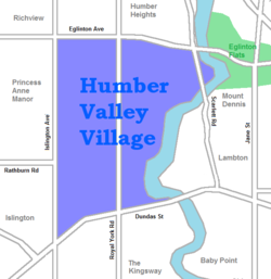
Humber Valley Village is a neighbourhood located in Toronto, Ontario, Canada. It is within the former suburb of Etobicoke and includes some of the most expensive real estate in the metropolitan west end. The boundaries are from Dundas Street on the south to Islington Avenue to the west, Eglinton Avenue to the north, and the Humber River in the east. The neighbourhood is in the political riding of Etobicoke Centre.

Contents

Character

This neighbourhood can be further broken down into smaller communities. The triangular quadrant north of Dundas from Islington to Royal York, but south of Reigate is known as Chestnut Hills. The area surrounding Edenbridge, on the west side of Royal York is known as Lincoln Woods. The northern corner of Islington and Eglinton is sometimes referred to as The Greens of St. George's. Sometimes streets in the neighbourhood become their own little community as well, for example people tend to connect to names like Valecrest, North Dr, Wimbleton, all of which are streets in this neighbourhood.

This neighbourhood is the wealthiest part of Etobicoke, and considered at par with the exclusive neighbourhoods that developed along Avenue Rd, and Yonge St, between Bloor and Highway 401. This wealth is evident in the schools. Catchment areas for schools such as Lambton-Kingsway, Humber Valley Village, Our Lady of Sorrows Elementary School, Etobicoke Collegiate Institute, and Richview Collegiate Institute are very defined. In some cases, those who do not live in the boundaries must apply with a lottery system to gain acceptance. There is also an independent elementary school, Kingsway College School, in the area, located on Dundas St.

Residents of Humber Valley Village self-organize and fundraise through the Humber Valley Village Residents' Association (HVVRA), [1] which has a history of launching development challenges to the Ontario Municipal Board (OMB). Most notably, HVVRA ran a sustained public relations, legal and lobbying effort that resulted in a number of planning concessions by First Capital Realty (FCR) regarding a proposal for Humbertown Plaza. [2]

History

Although laid-out in farm lots by 1805, most of the lots were purchased by some of Etobicoke's early land owners who lived elsewhere in the township leaving this part of the Humber Valley little developed with no homes along what became Royal York Road from Dundas north to Eglinton. [3] The Iroquois shoreline, remnant of the ancient Lake Iroquois, which forms an escarpment along Dundas in Etobicoke, turns far to the north in this area, cut away by the Humber River creating the Humber Valley.

Robert Home Smith's estate at Edenbridge and Edenbrook, 1930 EtobicokeRobertSmithEstateEdenbridge.jpg
Robert Home Smith's estate at Edenbridge and Edenbrook, 1930

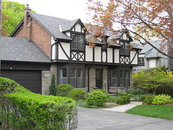
The western extension of St. Clair Avenue (now called Rathburn in Etobicoke) ran through the centre of the area and it was near this point the local developer Robert Home Smith built his home 'Edenbridge' (named after a village in southern England) overlooking the Humber Valley, at the turn of the century, after purchasing much of the surrounding land. To the west of Royal York another early resident, Frederick James, in 1908 developed his 'Red Gables' estate as a large landscaped park which, as the 'James Garden' landscaped park, remains today. [4] While Robert Home Smith developed land in The Kingsway neighbourhood to the south, the new 'Edenbridge' area was resurveyed and subdivided for development by Smith's company more slowly as the 'Humber Valley Surveys'; construction starting in the mid 1930s and continuing after Smith's death in 1935, until the 1960s. [5] This 30-year span produced many different styles of home as fashions changed, leading to a very different style of development than originally envisioned by Robert Home Smith. The designs include: Georgian, Colonial, Tudor, English Cottage, Cape Cod, ranch bungalows, split-level, contemporary and modernist. [6]

Later development

The neighbourhood was planned as a wealthy suburb like 'the Kingsway' to the south, which it has largely remained despite the later development of many apartments immediately to the west along an extended 'the Kingsway', north of Dundas to the west of Edenbridge, during Etobicoke's rapid urbanisation in the 1960s. The extension of St. Clair Avenue (Rathburn in Etobicoke) was redeveloped, in a similar style to the area in the west, as Anglesey; a winding street lined with apartments. Because Robert Home Smith had planned the, then slowly growing, area as a purely residential development, there are few institutions here. Rapid growth in Edenbridge and the higher density (north) Kingsway area to the west, necessitated the establishment of the Humber Valley Village public school, built in 1951, soon followed by the Humbertown Shopping Centre at Royal York and Dundas at the heart of 'Humber Valley Village'. The 1950s also saw the redevelopment of the Royal York and Dundas intersection as a highway style interchange, thought to be necessitated by urbanisation but now much criticised, which divided this neighbourhood from the older neighbourhoods to the south. Still mostly an exclusive and leafy neighbourhood, some recent high-density development is taking place along the short commercial stretch of Royal York in the south of the community across from the Humbertown Shopping Centre, such as the 'James Club' condominium, named after James Gardens. [7]

Parks

Located in the neighbourhood, James Garden is a botanical garden managed by Toronto Parks, Forestry and Recreation Division. James Gardens, Toronto, August 7th 2017 (36290023951).jpg
Located in the neighbourhood, James Garden is a botanical garden managed by Toronto Parks, Forestry and Recreation Division.

The defining element of this community would be the parks system. Not only are there five golf courses within one kilometre of every side of the borders, but huge networks of green space surround the Humber River. This connects to the Martin Goodman Trail, which follows Lake Ontario. Lambton Woods Park is located south of the city-owned Scarlet Woods Golf Course (c. 1974) [8] along the western banks of the Humber. [9] James Gardens is a botanical garden located north of Lambton Woods Park, and is managed by Toronto Parks, Forestry and Recreation Division. Built around Fred James home, the botanical garden was acquired by Metro Toronto in 1955 [10]

Other smaller parks include:

Schools

The Toronto District School Board, the city's public school board, operates one elementary school in the neighbourhood, Humber Valley Village Junior Middle School. Located on Hartfield Road, west of Royal York Road, north of Dundas Street, the property lies within the valley of the Humber River. It was established in 1951. In addition to public schools, the neighbourhood is also home to a music school and number of private schools, Kingsley Primary School, [11] Kingsway College School, and Leonardo da Vinci Academy. Leonardo da Vinci Academy is based at the former location for Buttonwood Hills Public School, and leases the property from Toronto Lands.

Sports

The Humber Valley Sharks is a hockey team from the Humber Valley Hockey Association. The Humber Valley Hockey Association [12] - was formed in 1953 by Mr. Stafford Smythe (whose father Conn Smythe was one of hockey's elder statesmen and former President of the Toronto Maple Leafs), Etobicoke Sports Hall of Famer and well known sportscaster Mr. Jack Stafford Jr. [13] and Mr. Ray Picard. One of the league's most notable Alumni, former Member of Parliament and Hockey Hall of Famer Ken Dryden played for one of the league's first two teams at 7 years of age. [14]

Institutions

Churches

St. Giles Kingsway Presbyterian Church is a church located in Humber Valley Village. St. Giles Kingsway.JPG
St. Giles Kingsway Presbyterian Church is a church located in Humber Valley Village.

Transportation

The Toronto Transit Commission operates buses along the main arteries of the neighbourhood. These include

These bus routes connects to Islington, Kipling, Royal York, Dundas West, Eglinton West, and Eglinton subway stations.

Related Research Articles

<span class="mw-page-title-main">Etobicoke</span> District of Toronto, Ontario, Canada

Etobicoke is an administrative district and former city within Toronto, Ontario, Canada. Comprising the city's west-end, Etobicoke is bordered on the south by Lake Ontario, on the east by the Humber River, on the west by Etobicoke Creek, the cities of Brampton, and Mississauga, the Toronto Pearson International Airport, and on the north by the city of Vaughan at Steeles Avenue West.

<span class="mw-page-title-main">Humber River (Ontario)</span> River in Canada

The Humber River is a river in Southern Ontario, Canada. It is in the Great Lakes Basin, is a tributary of Lake Ontario and is one of two major rivers on either side of the city of Toronto, the other being the Don River to the east. It was designated a Canadian Heritage River on September 24, 1999.

<span class="mw-page-title-main">The Kingsway, Toronto</span> Neighbourhood in Toronto, Ontario, Canada

The Kingsway is a residential neighbourhood in Toronto, Ontario, Canada. It is bounded by Bloor Street to the south, Dundas Street to the north, the Mimico Creek to the west and the Humber River to the east. The neighbourhood was officially known as Kingsway Park, which later became replaced by its nickname, The Kingsway. For planning purposes, the neighbourhood is known by the City of Toronto as "Kingsway South" to differentiate it from a more recent extension of The Kingsway north of Dundas Street. "Kingsway South" is not used by residents, due to confusion with the South Kingsway, a street located east of the Humber River and extending south from Bloor Street.

<span class="mw-page-title-main">Kipling Avenue</span> Road in Toronto, Canada

Kipling Avenue is a street in the cities of Toronto and Vaughan in Ontario, Canada. It is a concession road, 6 concessions (12 km) west from Yonge Street, and is a major north–south arterial road. It consists of three separate sections, with total combined length of 26.4 km. (16.4 mi.).

<span class="mw-page-title-main">Richview, Toronto</span> Neighbourhood in Toronto, Ontario, Canada

Richview, formally known as Willowridge-Martingrove-Richview, is a neighbourhood in the city of Toronto, Ontario, Canada. It is bounded on the west by Highway 401 and on the north by the highway and by Dixon Road, Royal York Road on the east, and Eglinton Avenue West along the south. Richview was originally established as a postal village within the then-agricultural Etobicoke Township, which later became the suburb of Etobicoke.

<span class="mw-page-title-main">Black Creek (Toronto)</span> River in Ontario, Canada

Black Creek is a river in the Golden Horseshoe region of Ontario, Canada. It flows from the city of Vaughan in the Regional Municipality of York to the Humber River in Toronto. Black Creek is smaller than most of the waterways in the Greater Toronto Area.

<span class="mw-page-title-main">Humber Heights-Westmount</span> Neighbourhood in Toronto, Ontario, Canada

Humber Heights-Westmount, also known as Humbervale, is a neighbourhood in Toronto, Ontario, Canada. The neighbourhood is bounded by the west bank of the Humber River, west to Royal York Road and south to Eglinton Avenue West. The Humber Creek divides the area into the northern 'Humber Heights' and the southern 'Westmount' centred along Scarlett Road and La Rose Avenue.

<span class="mw-page-title-main">Islington-City Centre West</span> Neighbourhood in Toronto, Ontario, Canada

Islington-City Centre West is a commercial and residential neighbourhood in Toronto, Ontario, Canada. One of four central business districts outside Downtown Toronto, it is bounded by Rathburn Road to the north, Islington Avenue to the east, Bloor Street to the south, Mimico Creek to the west.

<span class="mw-page-title-main">Rockcliffe–Smythe</span> Neighbourhood in Toronto, Ontario, Canada

Rockcliffe–Smythe is a neighbourhood in Toronto, Ontario, Canada. It was developed after World War II as part of the urbanization of the former suburb of York Township. It is in Ward 5 in the City of Toronto.

<span class="mw-page-title-main">The Queensway–Humber Bay</span> Neighbourhood in Toronto, Ontario, Canada

The Queensway–Humber Bay, known officially as Stonegate–Queensway, is a neighbourhood in the southwest of Toronto, Ontario, Canada. It is located in the southeast area of the former City of Etobicoke.

<span class="mw-page-title-main">Lambton, Toronto</span> Neighbourhood in Canada

Lambton is a neighbourhood in the city of Toronto, Ontario, Canada. It is situated on the east bank of the Humber River north and south of Dundas Street West. It is bounded on the north by Black Creek, on the east by Jane Street and on the south by St. Mark's Road. The area west of Gooch Avenue and south of Dundas Street West is also known as "Warren Park", the name of the housing sub-division built in the 1950s. The portion south of Dundas Street West is within the 'Lambton Baby Point' neighbourhood as defined by the City of Toronto.

<span class="mw-page-title-main">Princess Gardens</span> Neighbourhood in Toronto, Ontario, Canada

Princess Gardens is a neighbourhood in Toronto, Ontario, Canada. It is located in the western area of Toronto that was formerly the City of Etobicoke. Its boundaries are Eglinton Avenue to the north, Martin Grove to the west, Islington to the east, and Rathburn Road to the south. The southeastern part of this area is the separate neighbourhood of Thorncrest Village. The neighbourhood is divided into two areas: The portion east of Kipling Road is known as Princess Anne Manor, while the portion west of Kipling is Princess Margaret Gardens. They are named after Princess Anne, Princess Royal, and Princess Margaret, Countess of Snowdon, the daughter and sister of the late Queen Elizabeth II respectively. Both Princesses visited the Gardens and opened up Princess Margaret Public School during its opening ceremony. The southwestern part of the neighbourhood is also sometimes known as Glen Agar. Princess Gardens has some of the highest income Canadians in the Greater Toronto Area according to a 2016 census, at an average of $222,218 per year.

<span class="mw-page-title-main">Royal York Road</span> Thoroughfare in Toronto, Ontario

Royal York Road, historically known as Church Street or New Church Street, is a north-south arterial road in Toronto, Ontario, Canada. It is a concession road, 5 concessions (10 km) west of Yonge Street, and runs through many residential neighbourhoods, most notably Mimico and the Kingsway. It is classified as a "minor arterial" road by the city of Toronto.

<span class="mw-page-title-main">Lambton Mills</span> Place in Ontario, Canada

The Village of Lambton Mills was a settlement at the crossing of Dundas Street and the Humber River. The settlement was on both sides of the Humber River, in both the former Etobicoke Township and York Township, within today's City of Toronto, Ontario, Canada. It extended as far west as Royal York Road at Dundas, as far north as the still-existing CPR rail line north of Dundas, as far east as Scarlett Road and as far south as today's Queen Anne Road. The area on the east side of the river is still known as Lambton, although the current neighbourhood encompasses very little of the original Lambton Mills village.

<span class="mw-page-title-main">Dundas Street</span> Major arterial road in Ontario, Canada

Dundas Street is a major historic arterial road in Ontario, Canada. The road connects the city of Toronto with its western suburbs and several cities in southwestern Ontario. Three provincial highways—2, 5, and 99—followed long sections of its course, although these highway segments have since been downloaded to the municipalities they passed through. Originally intended as a military route to connect the shipping port of York to the envisioned future capital of London, Ontario, the street today connects Toronto landmarks such as Yonge–Dundas Square and the city's principal Chinatown to rural villages and the regional centres of Hamilton and London.

References

  1. "HVVRA" . Retrieved 8 May 2021.
  2. "First Capital Plans A Makeover For Humbertown" . Retrieved 8 May 2021.
  3. Atlas of the County of York, Etobicoke Township. Miles & Co., 1878
  4. "James Gardens and the Humber Valley Village in Etobicoke Ontario!". Archived from the original on 2010-07-06. Retrieved 2009-07-27.
  5. "Toronto Neighbourhoods". Archived from the original on 2003-10-09. Retrieved 2009-07-27.
  6. http://torontoneighbourhoods.net/regions/etobicoke/76_homes.html] Archived 2008-10-07 at the Wayback Machine
  7. "James Club". www.jamesclub.ca. Retrieved 22 April 2018.
  8. "Scarlett Woods Golf Course". OntarioGolf.com. Retrieved 22 April 2018.
  9. "Archived copy". Archived from the original on 2017-11-13. Retrieved 2017-06-21.{{cite web}}: CS1 maint: archived copy as title (link)
  10. "Parks, Forestry and Recreation : James Gardens". Archived from the original on 2017-06-14. Retrieved 2017-06-21.
  11. "Kingsley School - Private Primary School - Toronto Etobicoke". Kingsley School - Private Primary School - Toronto Etobicoke. Retrieved 22 April 2018.
  12. "Humber Valley Hockey Association". hvha.org. Retrieved 25 October 2019.
  13. "Etobicoke Sports Hall Of Fame". etobicokesports.ca. 16 July 2003. Retrieved 25 October 2019.
  14. "Humber Valley Hockey Association". hvha.org. Retrieved 25 October 2019.
  15. "Home - Humbertown". Humbertown. Retrieved 22 April 2018.
  16. "Heritage Toronto Moment: Royal York Golf Club - Urban Toronto". urbantoronto.ca. Retrieved 22 April 2018.
  17. "hvuc". hvuc. Retrieved 22 April 2018.
  18. "St. Giles Kingsway Presbyterian Church: We Are Presbyterian". Archived from the original on 2009-10-04. Retrieved 2009-07-08.
  19. "ST. GILES KINGSWAY CHURCH HISTORY" (PDF). squarespace.com. Retrieved 2021-05-27.
  20. "St.Georges on the Hill" . Retrieved 8 May 2018.