Bayview Woods-Steeles

Last updated

Bayview Woods-Steeles
Neighbourhood
Finch at Old Cummer.jpg
View from Finch Avenue, looking west from Leslie Street.
Bayview Woods-Steeles.PNG
CountryFlag of Canada (Pantone).svg  Canada
ProvinceFlag of Ontario.svg  Ontario
CityToronto
Municipality established1850 York Township
Changed municipality1922 North York from York Township
Changed municipality1998 Toronto from North York

Bayview Woods-Steeles is a neighbourhood located in the northern tip of the city of Toronto, Ontario, Canada in the district of North York. It is part of federal and provincial electoral district Don Valley North, and Toronto electoral ward 17: Don Valley North. In 2006, it had a population of 13,295. [1] The area is divided by a series of ravines, and is often not considered a neighbourhood unto itself. Rather the sections are more often divided between the neighbouring areas of Hillcrest Village, Bayview Village, and Newtonbrook.

Contents

The neighbourhood is bordered by Steeles Avenue East to the north, Leslie Street to the east, Bayview Avenue to the west, and Finch Avenue East to the south. Several branches of the Don River meet in the middle of this neighbourhood and there is no shortage of greenspace as a result, though much is not usable, since it consists mostly of ravines. This neighbourhood is also notable for varying greatly in elevation, with the section in Cummer Avenue between Bayview and Leslie being especially steep.

Demographics

Bayview Woods-Steeles is a middle-income neighbourhood with an equal amount of single detached homes as apartment buildings with 5+ stories. The ownership rate is close to 60% which is well over the average for the city. In 2006, 655 people had an income of $60,000 and above which increased only increased over the years. In 2011 there were 1035 people with an income of $60,000 and above living in the Bayview Woods-Steels neighbourhood, making this a middle-income neighbourhood.[ citation needed ]

There is a very large population of Chinese immigrants arriving each year and the neighbourhood is home to a large Chinese population (almost 30%). In 2006 there were 275 Chinese immigrants living in this neighbourhood and in 2011 there was a decrease of 25 people; there were 250 Chinese immigrants in the Bayview Woods-Steeles neighbourhood.[ citation needed ] There is also a strong Jewish community living in the area. [ citation needed ]

Bayview Woods-Steeles' major ethnic and cultural groups (by ancestry) in 2001: [1]

The percentage of population below the poverty line was 18% in 2001. [1]

Education

Tyndale University is a private post-secondary institution located in the neighbourhood. Morrow Park Tyndale Bayview Campus.jpg
Tyndale University is a private post-secondary institution located in the neighbourhood.

Two public school boards operate schools in Bayview Woods – Steeles, the separate Toronto Catholic District School Board (TCDSB), and the secular Toronto District School Board (TDSB).

TDSB operates three primary education institutions, Steelesview Public School, Lester B. Pearson Elementary School, and Zion Heights Middle School. TDSB does not operate a school that provides secondary education in the neighbourhood, with TDSB secondary students residing in Bayview Woods – Steeles attending schools in adjacent neighbourhoods. Additionally, TCDSB operates one elementary school in the area, Blessed Trinity Catholic School, and one secondary school, St. Joseph's Morrow Park Catholic Secondary School .

The French first language public secular school board, Conseil scolaire Viamonde, and it separate counterpart, Conseil scolaire catholique MonAvenir also offer schooling to applicable residents of Bayview Woods – Steeles, although they do not operate a school in the neighbourhood. CSCM and CSV students attend schools situated in other neighbourhoods in Toronto.

In addition to primary and secondary institutions, Tyndale University is also located in the neighbourhood. Tyndale is a private post-secondary institution.

Recreation

The Don River at Bayview Avenue. The river forms a part of the Toronto ravine system. Bayview East Don Bridge 1.jpg
The Don River at Bayview Avenue. The river forms a part of the Toronto ravine system.

Several municipal parks are located in the Bayview Woods – Steeles, including Bestview Park, Cummer Park, Ruddington Park, Garnier Park, and Pineway Park. Several parks are situated near the Don Valley, a ravine network that bisects the neighbourhood. The valley forms a part of the Toronto ravine system. Municipal parks situated in the neighbourhood are managed by the Toronto Parks, Forestry and Recreation Division. In addition to municipal parks, the division also manages Cummer Park Community Centre, which has a swimming pool, an arena, and a skate park.

Transportation

Several major roadways bound the neighbourhood including Steeles Avenue to the north, Finch Avenue to the south, and Bayview Avenue to the west.

Public transit in the neighbourhood is provided by the Toronto Transit Commission (TTC). The TTC operates several bus routes in the neighbourhood, 11 Bayview, 53 Steeles East, 42 Cummer, 39 Finch East and 51 Leslie. In addition to the TTC, bus routes operated by York Region Transit may be accessed in Bayview Woods – Steeles. The neighbourhood is home to one commuter railway station, Old Cummer GO Station. The station provides access to the Richmond Hill line, and is operated by GO Transit.

Related Research Articles

<span class="mw-page-title-main">Bridle Path, Toronto</span> Neighbourhood in Toronto, Ontario, Canada

The Bridle Path is a residential neighbourhood in Toronto, Ontario, Canada. It is characterized by large multimillion-dollar mansions and two to four acre lot sizes. It makes up part of Bridle Path–Sunnybrook–York Mills. Often referred to as "Millionaires' Row", as of 2014 it is the most affluent neighbourhood in Canada, with an average household income of $936,137, as well as by property values with an average dwelling value of $2.24M.

<span class="mw-page-title-main">Lawrence Park, Toronto</span> Neighbourhood in Toronto, Ontario, Canada

Lawrence Park is a neighbourhood in Toronto, Ontario, Canada. It is bordered by Yonge Street to the west and Bayview Avenue to the east, and from Blythwood Ravine on the south to Lawrence Avenue on the north. Lawrence Park was one of Toronto's first planned garden suburbs. Begun in the early part of the 20th century, it did not fully develop until after the Second World War. It was ranked the wealthiest neighbourhood in all of Canada in 2011.

<span class="mw-page-title-main">Jane and Finch</span> Neighbourhood in Toronto, Ontario, Canada

Jane and Finch is a neighbourhood located in the northwest end of Toronto, Ontario, Canada, in the district of North York. Centred at the intersection of Jane Street and Finch Avenue West, the area is roughly bounded by Highway 400 to the west, Black Creek to the east, Sheppard Avenue to the south, and Steeles Avenue to the north. Two city neighbourhoods cover the area commonly known as Jane and Finch. From Finch north to Steeles is considered part of the Black Creek community while from Finch south to Sheppard is called Glenfield-Jane Heights.

<span class="mw-page-title-main">Newtonbrook</span> Neighbourhood of Toronto

Newtonbrook is a neighbourhood in Toronto, Ontario, Canada. It is located in the area around Yonge Street and Finch Avenue in the district of North York between the east and west branches of the Don River. Officially, the area is divided into two neighbourhoods; Newtonbrook West and Newtonbrook East.

<span class="mw-page-title-main">Willowdale, Toronto</span> Neighbourhood in Toronto, Ontario, Canada

Willowdale is a neighbourhood in the city of Toronto, Ontario, Canada, located in the district of North York. It developed from three postal villages: Newtonbrook, Willowdale and Lansing.

<span class="mw-page-title-main">Henry Farm</span> Neighbourhood in Toronto, Ontario, Canada

Henry Farm is a neighbourhood in the City of Toronto, Ontario, Canada. It is located in the north central part of the city within the former city of North York.

<span class="mw-page-title-main">Bayview Village</span> Neighbourhood in Toronto, Ontario, Canada

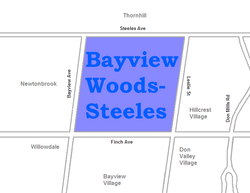
Bayview Village is a neighbourhood in Toronto, Ontario, Canada. It is part of the federal Don Valley North riding and the provincial Don Valley North electoral district, and Toronto electoral Ward 17: Don Valley North. In 2006, it had a population of 15,370.

<span class="mw-page-title-main">Humber Summit</span> Neighbourhood in Toronto, Ontario, Canada

Humber Summit is a neighbourhood in Toronto, Ontario, Canada. It is one of the northernmost neighbourhoods in Toronto, located in the North York district of the city. It is bounded by Steeles Avenue to the north, Highway 400 to the east, Finch Avenue to the south, and follows the Humber River to the west.

<span class="mw-page-title-main">Humbermede</span> Neighbourhood in Toronto, Ontario, Canada

Humbermede, often called Emery, is a neighbourhood of Toronto, Ontario, Canada. Humbermede, like many of the "Humber" neighbourhoods in the city, gets its name from the Humber River. It is bounded on the west by the Humber River, on the north by Finch Avenue West, on the east by the Highway 400 and on the south by Sheppard Avenue West.

<span class="mw-page-title-main">York University Heights</span> Neighbourhood in Toronto, Ontario, Canada

York University Heights, also known as Northwood Park, is a neighbourhood in Toronto, Ontario, Canada. It is one of Toronto's northernmost neighbourhoods, located along the northern boundary of Steeles Avenue in the former city of North York. The neighbourhood is so named because it contains the main campus of York University. This area is most popular with immigrants of Italian and Chinese descent who have established communities in the area. It is located between Sheppard Avenue and Steeles Avenue east of Black Creek.

<span class="mw-page-title-main">Westminster-Branson</span> Neighbourhood in Toronto, Ontario, Canada

Westminster-Branson is a neighbourhood in the city of Toronto, Ontario, Canada. It is in the northernmost part of the city within the area of North York.

<span class="mw-page-title-main">Lansing, Toronto</span> Neighbourhood in Toronto, Ontario, Canada

Lansing is a neighbourhood in Toronto, Ontario, Canada. It originated as a minor settlement of a store, other services and a post office at the corner of Yonge Street and Sheppard Avenue and later got consolidated with Toronto as sprawling development took place. A larger area was designated as the postal village of Lansing. The City of Toronto labels it as Lansing-Westgate for neighbourhood planning purposes with the boundaries Yonge Street to the east, Highway 401 to the south, Bathurst Street to the west and Burnett Avenue to the north.

<span class="mw-page-title-main">Victoria Village</span> Neighbourhood in Toronto, Ontario, Canada

For the settlement established by former slaves in Guyana known as Victoria Village see Victoria, Guyana

<span class="mw-page-title-main">Parkwoods</span> Neighbourhood in Toronto, Ontario, Canada

Parkwoods or sometimes referred to as Parkwoods-Donalda, is a neighbourhood in Toronto, Ontario, Canada. It is a geographically large neighbourhood located just south of Ontario Highway 401, west of Victoria Park Avenue, north of Lawrence Avenue East and east of the Don Valley Parkway.

<span class="mw-page-title-main">Pleasant View, Toronto</span> Neighbourhood in Toronto, Ontario, Canada

Pleasant View is a neighbourhood in the city of Toronto, Ontario, Canada that is located in the district of North York at the northern end of the city. It is bordered by Victoria Park to the East, Sheppard Avenue to the South, Highway 404 to the west and the Finch hydro corridor to the north. The neighbourhood is home to several high-rise apartment and condominium buildings, such as The Clippers.

<span class="mw-page-title-main">Don Valley Village</span> Neighbourhood in Toronto, Ontario, Canada

Don Valley Village is a neighbourhood in the city of Toronto, Ontario, Canada. It is located in the former suburb of North York. Located north of Highway 401 and bisected by Don Mills Road, it is bounded by Sheppard Avenue to the south, Leslie Street to the west, Finch Avenue to the north and Highway 404 to the east. Like the nearby Don River Valley, the neighbourhood has hill and dale topography.

<span class="mw-page-title-main">Hillcrest Village</span> Neighbourhood in Toronto, Ontario, Canada

Hillcrest Village is a neighbourhood located in Toronto, Ontario, Canada. It is located in the northern district of North York. It is bordered by Finch to the South, Leslie Street to the West, Steeles to the North and Victoria Park to the East. Both neighbourhoods share the Don Valley as a point of reference in the Eastern border of the neighbourhoods.

<span class="mw-page-title-main">Clairlea</span> Neighbourhood in Toronto, Ontario, Canada

Clairlea is a safe, quiet, middle to upper-middle income neighbourhood in Toronto, Ontario, Canada that features well treed streets and detached homes with large backyards. The neighbourhood is located in east Toronto just east of Victoria Park Avenue.

<span class="mw-page-title-main">Eglinton East</span> Neighbourhood in Toronto, Ontario, Canada

Eglinton East, historically known as Knob Hill, is a residential and commercial neighbourhood in Toronto, Ontario, Canada. It is bounded by Stansbury Crescent, Citadel Drive, and West Highland Creek to the north, Midland Avenue to the west, the CNR rail line, Brimley Road, and Eglinton Avenue to the south, and Bellamy Road North to the east.

<span class="mw-page-title-main">Morningside Heights, Toronto</span> Neighbourhood in Toronto, Ontario, Canada

Morningside Heights is a residential neighbourhood in Toronto, Ontario, Canada. It is located in the northeast corner of the city, in the district of Scarborough, just north of the neighbourhood of Malvern and west of Rouge Park and the Rouge. The subdivision, comprising approximately 750 acres (3.0 km2), was one of the last large tracts of undeveloped land within the City of Toronto, located between Finch Avenue East and Steeles Avenue East, from Tapscott Road to the Rouge River.

References

43°47′49″N79°22′59″W / 43.797°N 79.383°W / 43.797; -79.383