Trinity-Bellwoods

Last updated

Trinity–Bellwoods
Neighbourhood
TTC 501 ALRV 4207 at Bathurst and Queen August 10, 2013.JPG
View of Trinity-Bellwoods from Bathurst Street and Queen Street West
Trinity-Bellwoods map.PNG
Vicinity of Trinity–Bellwoods
Toronto map.png
Red pog.svg
Location within Toronto
Coordinates: 43°38.8′N79°24.5′W / 43.6467°N 79.4083°W / 43.6467; -79.4083
CountryFlag of Canada (Pantone).svg  Canada
Province Flag of Ontario.svg  Ontario
City Toronto
Government
  City Councillor Dianne Saxe
  Federal M.P. Chrystia Freeland
  Provincial M.P.P. Jessica Bell

Trinity-Bellwoods is an inner city neighbourhood in Toronto, Ontario, Canada. It is bounded on the east by Bathurst Street, on the north by College Street, on the south by Queen Street West, and by Dovercourt Road on the west. It has a large Portuguese (mostly originally from the Azores and Madeira islands) and Brazilian community, and many local Portuguese-Canadian businesses are located along Dundas Street West, continuing west into Little Portugal; this stretch further west along Dundas is known as Rua Açores .

Contents

The neighbourhood takes its name from Trinity Bellwoods Park, built around the former Garrison Creek ravine. Bounded on the north by Dundas Street West and on the south by the Queen Street West district, the park is immediately accessible from major pedestrian and bicycling thoroughfares and is bounded on the east and the west by quiet residential streets. Accordingly, the park has a large natural "constituency". The park also sports a range of environments, including tennis courts, a playground, a hockey rink, a dog walking bowl, a grove, a range of picnic tables, a greenhouse, a community center, and a swimming pool. The northwestern panhandle is home to a farmer's market on Tuesday afternoons from spring to fall.

History

Trinity College, c. 1856. Completed only four years earlier, the building was situated in present-day Trinity Bellwoods Park. Oldtrinnorthside.jpg
Trinity College, c. 1856. Completed only four years earlier, the building was situated in present-day Trinity Bellwoods Park.

Trinity Bellwoods Park was the original site of Trinity College, one of the colleges that now make up the University of Toronto. The college building, which was completed in 1852, stood roughly at the centre of the park, and remained there for just over 100 years. Today the only remaining artifacts of the school are its restored gates at the south end of the park.

By 1900, the college and its picturesque surroundings attracted residential development. Most of the surrounding streets were filled in with tall, narrow houses of the Bay-and-gable or Gothic Revival style characteristic of much of Toronto's housing stock from that era. A number of fine homes from the period are scattered throughout the neighborhood.

During the 20th century the neighborhood became a landing site for immigrants of various nationalities, setting a pattern for the next six to seven decades. From the 1920s and 1930s the area became home to many Polish and Ukrainian immigrants; the Bathurst-Queen area was the heart of the city's Polish and Ukrainian communities until the 1960s. By the 1960s, the area had become popular among the immigrants from Portugal, who now define much of the neighborhood's character. The businesses along Ossington Avenue just north of Queen Street have changed in the last decade, with former sports bars and social clubs becoming trendy restaurants, bars and cafes. Some of this conversion has been due to higher commercial rents along Queen Street relative to Ossington Avenue properties. The high conversion rate into bars and the accompanying late-night noise prompted a city-ordered halt to conversions and new liquor serving licenses along Ossington.

Demographic

According to the 2011 National Household Survey, Ontario remains the most common place of birth for respondents of the area bordered by Dovercourt, Dundas West, Queen West and Gore Avenue, with 1800 claiming place of birth in Ontario. The second most common place of birth was Portugal, with 785. In descending order, respondents indicated that they had been born in another province or territory in Canada (370), Vietnam (70), or Italy (35). [1]

Education

Three public school boards operate elementary schools in Trinity–Bellwoods, the Conseil scolaire Viamonde (CSV), the Toronto Catholic District School Board (TCDSB), and the Toronto District School Board (TDSB). CSV and TDSB are secular public school boards, the former being French-based, the latter being English-based. TCDSB is an English-based separate public school board. Elementary schools in the area include:

Recreation

Gates at the southern entrance to Trinity Bellwoods Park. Trinity Bellwoods Gates.jpg
Gates at the southern entrance to Trinity Bellwoods Park.

Trinity–Bellwoods is home to several parks, including Trinity Bellwoods Park. Parks in the neighbourhood are managed by the Toronto Parks, Forestry and Recreation Division. Trinity Bellwoods Park is a major park that occupies the ravines that surrounded the buried Garrison Creek. The park also features Crawford Street Bridge, a buried, but intact bridge in the north part of municipal park.

Other notable attractions and landmarks in the area include the Museum of Contemporary Canadian Art, and St. Matthias Bellwoods.

Related Research Articles

<span class="mw-page-title-main">Bendale</span> Neighbourhood in Toronto, Ontario, Canada

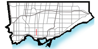
Bendale, also called Cedarbrae and Midland Park, is a residential neighbourhood in the eastern part of Toronto, Ontario, Canada. It is located in the former suburb of Scarborough. It is centred on the intersection of Lawrence Avenue East and Brimley Road. Its boundaries, as defined by the City, are Midland Avenue from Lawrence, north to Highway 401, east to McCowan, south to Lawrence, east to West Highland Creek, south-west along West Highland Creek, then follow several side streets parallel to the Creek, north to Midland Avenue. The area north of Ellesmere is typically considered the Scarborough City Centre district, and is not considered in this neighbourhood article.

<span class="mw-page-title-main">Little Italy, Toronto</span> Neighbourhood in Toronto, Ontario, Canada

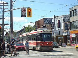
Little Italy, sometimes referred to as College Street West, is a district in Toronto, Ontario, Canada. It is known for its Italian Canadian restaurants and businesses. There is also a significant Latin-Canadian and Portuguese-Canadian community in the area. The district is centred on a restaurant/bar/shopping strip along College Street, centred on College Street, imprecisely between Harbord Street and Dundas Street, and spreading out east and west between Bathurst Street and Ossington Avenue. It is contained within the larger city-recognized neighbourhood of Palmerston-Little Italy.

<span class="mw-page-title-main">Trinity—Spadina</span> Former Canadian federal electoral district

Trinity—Spadina was a federal electoral district in Ontario, Canada, that was represented in the House of Commons of Canada from 1988 to 2015.

<span class="mw-page-title-main">Dovercourt Park</span> Neighbourhood in Toronto, Ontario, Canada

Dovercourt Park or Dovercourt Village is a neighbourhood in Toronto, Ontario, Canada situated north of Bloor Street between Christie Street to the east, the CPR railway lines to the north, and Dufferin Street to the west.

<span class="mw-page-title-main">Brockton Village</span> Neighbourhood in Toronto, Ontario, Canada

Brockton Village is a former town, and now the name of a neighbourhood, in Toronto, Ontario, Canada. It comprises a section of the old Town of Brockton which was annexed by the City of Toronto in 1884.

<span class="mw-page-title-main">Pelmo Park-Humberlea</span> Neighbourhood in Toronto, Ontario, Canada

Pelmo Park-Humberlea is a neighbourhood in Toronto, Ontario, Canada. It is located north-west of the central core, in the former suburb of North York. Many of the neighbourhoods in this quadrant of the city can aptly be described as family neighbourhoods with access to parks, green space and a slower pace than found closer to downtown.

<span class="mw-page-title-main">Yorkdale–Glen Park</span> Neighbourhood in Toronto, Ontario, Canada

Yorkdale–Glen Park is a neighbourhood in the city of Toronto, Ontario, Canada, located in the former suburb of North York. It is bounded by Highway 401 to the north, Allen Road to the east, a line south of Stayner Avenue to the south, and the CNR tracks to the west.

<span class="mw-page-title-main">Lawrence Manor</span> Neighbourhood in Toronto, Ontario, Canada

Lawrence Manor is a neighbourhood in the city of Toronto, Ontario, Canada. This neighbourhood is bounded by Bathurst Street on the east, Highway 401 to the north, the Allen to the west, and Lawrence Avenue to the south. The western side of the area borders along Bathurst Heights and the large public housing project.

<span class="mw-page-title-main">Clanton Park, Toronto</span> Neighbourhood in Toronto, Ontario, Canada

Clanton Park is a neighbourhood in Toronto, Ontario, Canada. Located in the district of North York, it is part of federal and provincial electoral district York Centre, and Toronto electoral wards 9: York Centre (West) and 10: York Centre (East). In 2016, it had a population of 16,472, a 12.7% rise from 2011.

<span class="mw-page-title-main">Westminster-Branson</span> Neighbourhood in Toronto, Ontario, Canada

Westminster-Branson is a neighbourhood in the city of Toronto, Ontario, Canada. It is in the northernmost part of the city within the area of North York.

<span class="mw-page-title-main">Don Valley Village</span> Neighbourhood in Toronto, Ontario, Canada

Don Valley Village is a neighbourhood in the city of Toronto, Ontario, Canada. It is located in the former suburb of North York. Located north of Highway 401 and bisected by Don Mills Road, it is bounded by Sheppard Avenue to the south, Leslie Street to the west, Finch Avenue to the north and Highway 404 to the east. Like the nearby Don River Valley, the neighbourhood has hill and dale topography.

<span class="mw-page-title-main">Hillcrest Village</span> Neighbourhood in Toronto, Ontario, Canada

Hillcrest Village is a neighbourhood located in Toronto, Ontario, Canada. It is located in the northern district of North York. It is bordered by Finch to the South, Leslie Street to the West, Steeles to the North and Victoria Park to the East. Both neighbourhoods share the Don Valley as a point of reference in the Eastern border of the neighbourhoods.

<span class="mw-page-title-main">Dufferin Grove</span> Neighbourhood in Toronto, Ontario, Canada

Dufferin Grove is a neighbourhood located in Toronto, Ontario, Canada, west of downtown. The neighbourhood is bordered by Bloor Street West to the north, Ossington Ave to the east, College Street to the south, and Dufferin Street to the west.

<span class="mw-page-title-main">The Queensway–Humber Bay</span> Neighbourhood in Toronto, Ontario, Canada

The Queensway–Humber Bay, known officially as Stonegate–Queensway, is a neighbourhood in the southwest of Toronto, Ontario, Canada. It is located in the southeast area of the former City of Etobicoke.

<span class="mw-page-title-main">Alexandra Park, Toronto</span> Neighbourhood in Toronto, Ontario, Canada

Alexandra Park is a neighbourhood located in downtown Toronto, Ontario, Canada. Alexandra Park is bounded by Dundas Street West on the north, Spadina Avenue on the east, Queen Street West on the south, and Bathurst Street on the west. Alexandra Park consists of private and public housing, with at grade retail along Queen Street West and Spadina Avenue, some institutional, and several commercial buildings scattered through the neighborhood. The neighborhood takes its name from Alexandra Park, a municipal park at the south-east corner of Dundas Street West and Bathurst Street. The park is named for Queen Alexandra, whose husband, King Edward VII, was the first future monarch to visit Toronto.

<span class="mw-page-title-main">Little Portugal, Toronto</span> Neighbourhood in Toronto, Ontario, Canada

Little Portugal is a neighbourhood and ethnic enclave in Toronto, Ontario, Canada. It is located west of downtown in the "Old" City of Toronto. It is bound on the west by Lansdowne Avenue, on the north by College Street, on the east by Ossington Avenue and on the south by the Go Transit and Union Pearson Express railway tracks. The area is mainly residential, with Portuguese businesses along Dundas Street West and College Street. The area west of Dufferin Street was a part of the former Town of Brockton. The area to the east of Dufferin and south of Dundas Street is also known as "Beaconsfield Village" dating back to the days of the sub-division of lots in the area around Beaconsfield Avenue.

<span class="mw-page-title-main">Maple Leaf, Toronto</span> Neighbourhood in Toronto, Ontario, Canada

Maple Leaf is a neighbourhood in the city of Toronto, Ontario, Canada. It is located in the southwest of the North York district. Its approximate borders are Lawrence Avenue to the south, Culford Road to the west, Highway 401 to the north, and the CNR rail lines east of Keele Street to the east.

<span class="mw-page-title-main">Ossington Avenue</span> Thoroughfare in Toronto, Ontario

Ossington Avenue is a main or arterial street in Toronto, Ontario, Canada, west of downtown. While the northern 3 kilometres (1.9 mi) of Ossington Avenue is residential, its southern terminus is popularly known as the Ossington Strip, an area popular for its dining, nightlife and shopping establishments.

<span class="mw-page-title-main">Armour Heights</span> Neighbourhood in Toronto, Ontario, Canada

Armour Heights is a neighbourhood in Toronto, Ontario, Canada, in the district of North York. It is bounded by Wilson Avenue to the south, Bathurst Street to the west, and the west branch of the Don River to the north and east. Highway 401 cuts through the centre of the neighbourhood.

<span class="mw-page-title-main">Ledbury Park</span> Neighbourhood in Toronto, Ontario, Canada

Ledbury Park is a neighbourhood in Toronto, Ontario, Canada. It is located in the southern part of the North York area, just across the border from Midtown Toronto. Its boundaries are Avenue Road to the east, Lawrence Avenue to the south, Bathurst Street to the West, and Wilson Avenue and Highway 401 to the north.

References

  1. "2011 National Household Survey Data Tables". Statistics Canada.