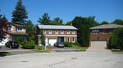
The Bridle Path is a residential neighbourhood in Toronto, Ontario, Canada. It is characterized by large multimillion-dollar mansions and two to four acre lot sizes. It makes up part of Bridle Path–Sunnybrook–York Mills. Often referred to as "Millionaires' Row", as of 2014 it is the most affluent neighbourhood in Canada, with an average household income of $936,137, as well as by property values with an average dwelling value of $2.24M.

Newtonbrook is a neighbourhood in Toronto, Ontario, Canada. It is located in the area around Yonge Street and Finch Avenue in the district of North York between the east and west branches of the Don River. Officially, the area is divided into two neighbourhoods; Newtonbrook West and Newtonbrook East.
Willowdale is a neighbourhood in the city of Toronto, Ontario, Canada, located in the district of North York. It developed from three postal villages: Newtonbrook, Willowdale and Lansing.

Henry Farm is a neighbourhood in the City of Toronto, Ontario, Canada. It is located in the north central part of the city within the former city of North York.

Bayview Village is an neighbourhood in Toronto, Ontario, Canada. It is part of the federal Don Valley North riding and the provincial Don Valley North electoral district, and Toronto electoral Ward 17: Don Valley North. In 2006, it had a population of 15,370.

Humber Summit is a neighbourhood in Toronto, Ontario, Canada. It is one of the northernmost neighbourhoods in Toronto, located in the North York district of the city. It is bounded by Steeles Avenue to the north, Highway 400 to the east, Finch Avenue to the south, and follows the Humber River to the west.

Humbermede, often called Emery, is a neighbourhood of Toronto, Ontario, Canada. Humbermede, like many of the "Humber" neighbourhoods in the city, gets its name from the Humber River. It is bounded on the west by the Humber River, on the north by Finch Avenue West, on the east by the Highway 400 and on the south by Sheppard Avenue West.

York University Heights, also known as Northwood Park, is a neighbourhood in Toronto, Ontario, Canada. It is one of Toronto's northernmost neighbourhoods, located along the northern boundary of Steeles Avenue in the former city of North York. The neighbourhood is so named because it contains the main campus of York University. This area is most popular with immigrants of Italian and Chinese descent who have established communities in the area. It is located between Sheppard Avenue and Steeles Avenue east of Black Creek.

Yorkdale–Glen Park is a neighbourhood in the city of Toronto, Ontario, Canada, located in the former suburb of North York. It is bounded by Highway 401 to the north, Allen Road to the east, a line south of Stayner Avenue to the south, and the CNR tracks to the west.

Lawrence Manor is a neighbourhood in the city of Toronto, Ontario, Canada. This neighbourhood is bounded by Bathurst Street on the east, Highway 401 to the north, the Allen to the west, and Lawrence Avenue to the south. The western side of the area borders along Bathurst Heights and the large public housing project.

Westminster-Branson is a neighbourhood in the city of Toronto, Ontario, Canada. It is in the northernmost part of the city within the area of North York.

For the settlement established by former slaves in Guyana known as Victoria Village see Victoria, Guyana

Pleasant View is a neighbourhood in the city of Toronto, Ontario, Canada that is located in the district of North York at the northern end of the city. It is bordered by Victoria Park to the East, Sheppard Avenue to the South, Highway 404 to the west and the Finch hydro corridor to the north. The neighbourhood is home to several high-rise apartment and condominium buildings, such as The Clippers.

Don Valley Village is a neighbourhood in the city of Toronto, Ontario, Canada. It is located in the former suburb of North York. Located north of Highway 401 and bisected by Don Mills Road, it is bounded by Sheppard Avenue to the south, Leslie Street to the west, Finch Avenue to the north and Highway 404 to the east. Like the nearby Don River Valley, the neighbourhood has hill and dale topography.

Bayview Woods-Steeles is a neighbourhood located in the northern tip of the city of Toronto, Ontario, Canada in the district of North York. It is part of federal and provincial electoral district Don Valley North, and Toronto electoral ward 17: Don Valley North. In 2006, it had a population of 13,295. The area is divided by a series of ravines, and is often not considered a neighbourhood unto itself. Rather the sections are more often divided between the neighbouring areas of Hillcrest Village, Bayview Village, and Newtonbrook.

Rouge is a neighbourhood in the northeastern area of Toronto, Ontario, within the former city of Scarborough. It is Toronto's largest neighbourhood by surface area; however, unlike other neighbourhoods, most of its area remains undeveloped, as the neighbourhood is adjacent to Rouge National Urban Park.

Eglinton East, historically known as Knob Hill, is a residential and commercial neighbourhood in Toronto, Ontario, Canada. It is bounded by Stansbury Crescent, Citadel Drive, and West Highland Creek to the north, Midland Avenue to the west, the CNR rail line, Brimley Road, and Eglinton Avenue to the south, and Bellamy Road North to the east.
Morningside Heights is a residential neighbourhood in Toronto, Ontario, Canada. It is located in the northeast corner of the city, in the district of Scarborough, just north of the neighbourhood of Malvern and west of Rouge Park and the Rouge. The subdivision, comprising approximately 750 acres (3.0 km2), was one of the last large tracts of undeveloped land within the City of Toronto, located between Finch Avenue East and Steeles Avenue East, from Tapscott Road to the Rouge River.

Old Town is a neighbourhood and retail district in downtown Toronto, Ontario, Canada. It was the first of Toronto's named neighbourhoods, having acquired the moniker no later than 1815, at which time the original town of York was expanding. The old neighbourhood was referred to as "Old Town" by residents, and the new neighbourhood as "New Town". The site still has many buildings dating back to the nineteenth century.
Armour Heights is a neighbourhood in Toronto, Ontario, Canada, in the district of North York. It is bounded by Wilson Avenue to the south, Bathurst Street to the west, and the west branch of the Don River to the north and east. Highway 401 cuts through the centre of the neighbourhood.