Davisville Village

Last updated

Davisville
Neighbourhood
DavisvilleToronto.JPG
Skyline of Davisville Village, 2009
Davisville map.PNG
Vicinity
Toronto map.png
Red pog.svg
Location within Toronto
Coordinates: 43°42′04″N79°23′20″W / 43.701°N 79.389°W / 43.701; -79.389
CountryFlag of Canada (Pantone).svg Canada
Province Flag of Ontario.svg  Ontario
City Toronto
Area
  Total3.139 km2 (1.212 sq mi)
Population
 (2021) [1]
  Total32,837
  Density10,461/km2 (27,090/sq mi)

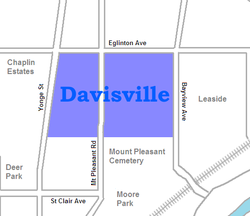
Davisville Village is a neighbourhood of Toronto, Ontario, Canada. It is located near the intersection of Davisville Avenue and Yonge Street. There is a subway station named Davisville at this intersection. The area directly abuts Mount Pleasant Cemetery, and has many massive apartment and condominium complexes built between the 1970s and the 2000s, as well as a number of office buildings. The area is within Midtown Toronto between St Clair and Eglinton. Davisville Village is represented at Toronto City Council by Councillor Josh Matlow.

Contents

History

Davisville was founded by John Davis in 1840. Davis opened the first post office in the neighbourhood and served as the post-master. [2] John Davis also started Davisville Pottery Company, which was the largest employer in the neighbourhood for several years. [2] In 1911, the Davis family sold a large portion of the land to Dovercourt Development Company to be developed. [2] Many single family homes were built between the 1920s and 1930s, and still exist today. [2]

Demographics

Historical population
YearPop.±%
200623,690    
201126,998+14.0%
201628,245+4.6%
202132,837+16.3%

The population of Davisville Village as of 2006 was 23,690. [3] The population of Davisville grew approximately 6.5% between 1996 and 2001, and another 8.5% between 2001 and 2006. [3] Davisville is a densely populated neighbourhood. Given an area of approximately 3.1 km2, it has a density of approximately 7,642 people per km2. [3]

Davisville is a fairly wealthy neighbourhood. Approximately 33% of Davisville's households earn more than $60,000 per year, which is more than double Toronto, which has an approximately 16.2% of its households earning more than $60,000 per year. [3]

Davisville has a higher percentage of Canadian citizens than Toronto according to the 2006 census data. Almost 48% of Davisville residents are Canadian citizens compared to 46% in city of Toronto. [3] Between 1961 and 1981 the immigrant population in Davisville remained fairly consistent at approximately 17% of the total population. By 1981 the immigrant population in Davisville increased rapidly and has continued to do so for the past three decades. [3]

The immigrants in Davisville come from many different countries. The country where most of Davisville's immigrants come from is the United Kingdom. In 2006 there were 955 people living in Davisville from the United Kingdom; 480 immigrants living in Davisville from the United States of America; and 470 immigrants from Iran. Other countries of origin for Davisville immigrants are China, India, Philippines, Germany, Poland, Jamaica, South Korea, Romania, and Russia. [3]

Davisville is serviced by two TTC subway stations, Davisville and Eglinton station on the Yonge-University line. It also has regular bus service on Eglinton Ave. E. and Bayview Ave. The easy access to public transportation and the proximity to the Downtown core, results in a higher percentage of residents using public transit and self-propulsion (walking/biking). Davisville's transportation mode shows that 46.5% of residents use public transit and 11.9% walked or biked to their destination, compared to the City of Toronto's transportation mode which shows that only 34.4% of residents use public transit and 8.8% walk or bike. [3] The 2006 census data also shows that Davisville neighbourhood has a lower percentage of vehicle users than the city of Toronto. 40.1% of residents in Davisville use car, trucks, vans, and/or motorcycles to get to their destination compared to Toronto's 55.8%. [3]

Real estate

Like many of Toronto's neighbourhoods, the real estate market in Davisville has undergone incredible growth over the past several years. Davisville has actually outperformed the Toronto real estate market in general in 2015 and thus far in 2016.[ when? ] The average price of a detached home is now $1,365,749, [4] an increase of 16% over 2015. This is attributed to the neighbourhood's schools, proximity to transportation and the amount shopping and restaurants available. [4]

Divisions

Davisville Village and it’s neighbour to the east, Leaside, are usually seen as being a part of the same neighbourhod. The city of Toronto assigns the Davisville Village into two official neighbourhoods:

Apartments surround Balliol Parkette in West Mount Pleasant. The majority of the people living in the area live in high/low-rise apartments. Square Spiral Al Green Toronto 2010.JPG
Apartments surround Balliol Parkette in West Mount Pleasant. The majority of the people living in the area live in high/low-rise apartments.

Mount Pleasant West

Mount Pleasant West is situated West of Mount Pleasant Road, North of Merton Street, East of Yonge Street and South of Keewatin Ave. 91% of people in this neighbourhood live in low/high rise apartment and condo buildings, which makes it one of the most building-dominated neighbourhoods in Toronto (comparable to the high-rise dense downtown core). [5] There are a number of affordable housing units in the area which factors into the lower income levels in this neighbourhood compared to the surrounding ones. Over 80% of residents are renters, which is approximately 30% over Toronto's average.

In 2003 Minto proposed a plan for two high-rise condominium buildings on Yonge street, south of Eglinton avenue. A majority of Davisville residents were strongly opposed to the development. The case was taken to the Ontario Municipal Board (OMB), which agreed that in order for Minto's plans to be approved, they needed to comply with the following conditions:

The Minto Quantum towers were built and completed in 2007. [7]

Mount Pleasant East

Mount Pleasant East is bordered to the east by Bayview Avenue, Moore Avenue to the south, Yonge Street to the west and Blythwood to the north. The people in this neighbourhood are predominantly in their working years and enjoy house value well above the norm for the city. [5] It is comparable to The Beaches in demographics and income.

Related Research Articles

<span class="mw-page-title-main">Forest Hill, Toronto</span> Neighbourhood in Toronto, Ontario, Canada

Forest Hill is a neighbourhood and former village in Midtown Toronto, Ontario, Canada, located north of Downtown Toronto. The village was amalgamated into Toronto in 1967 and the area has retained its name as a neighbourhood. Along with other neighbourhoods such as Rosedale and The Bridle Path, it is one of Toronto's wealthiest neighbourhoods, with an average income, among income recipients 15 or older in private households, of $157,600 in Forest Hill South and $89,700 in Forest Hill North, compared to the $59,250 average income in Toronto's Census Metropolitan Area and $54,450 in Canada as a whole.

<span class="mw-page-title-main">North Toronto</span> Place in Ontario, Canada

North Toronto is a former town and informal district located in the northern part of the Old Toronto district in Toronto, Ontario, Canada. Currently occupying a geographically central location within the city of Toronto, the Town of North Toronto was incorporated in 1890, when much of the area was still farmland, and annexed by Toronto in 1912. The name is still used to refer to the area in general, although Yonge–Eglinton and Midtown Toronto are officially used.

<span class="mw-page-title-main">Lawrence Park, Toronto</span> Neighbourhood in Toronto, Ontario, Canada

Lawrence Park is a neighbourhood in Toronto, Ontario, Canada. It is bordered by Yonge Street to the west and Bayview Avenue to the east, and from Blythwood Ravine on the south to Lawrence Avenue on the north. Lawrence Park was one of Toronto's first planned garden suburbs. Begun in the early part of the 20th century, it did not fully develop until after the Second World War. It was ranked the wealthiest neighbourhood in all of Canada in 2011.

<span class="mw-page-title-main">Toronto—St. Paul's (federal electoral district)</span> Federal electoral district in Ontario, Canada

Toronto—St. Paul's is a federal electoral district in Toronto, Ontario, Canada, that has been represented in the House of Commons of Canada since 1935. Before the 2015 election, the riding was known as St. Paul's.

<span class="mw-page-title-main">Willowdale, Toronto</span> Neighbourhood in Toronto, Ontario, Canada

Willowdale is a neighbourhood in the city of Toronto, Ontario, Canada, located in the district of North York. It developed from three postal villages: Newtonbrook, Willowdale and Lansing.

<span class="mw-page-title-main">St. Clair station</span> Toronto subway station

St. Clair is a subway station on Line 1 Yonge–University in Toronto, Ontario, Canada. The station opened in 1954 as part of the original Yonge Street subway.

<span class="mw-page-title-main">Davisville station</span> Toronto subway station

Davisville is a subway station on Line 1 Yonge–University in Toronto, Ontario, Canada. It is located at 1900 Yonge Street, where it intersects with Chaplin Crescent and Davisville Avenue. The station opened in 1954 as part of the original Toronto subway. In 2002, this station became accessible with elevators.

<span class="mw-page-title-main">Eglinton station</span> Toronto subway station

Eglinton is a subway station on Line 1 Yonge–University of the Toronto subway. Located on Eglinton Avenue, it is central to the Yonge–Eglinton neighbourhood in Midtown Toronto. Eglinton station is the seventh busiest station of the Toronto Transit Commission (TTC).

<span class="mw-page-title-main">Lawrence Avenue</span> Thoroughfare in Toronto, Ontario

Lawrence Avenue is a major east–west thoroughfare in Toronto, Ontario, Canada. It is divided into east and west portions by Yonge Street, the dividing line of east–west streets in Toronto.

<span class="mw-page-title-main">Toronto Belt Line Railway</span>

The Toronto Belt Line Railway was built during the 1890s in Toronto, Ontario, Canada. It consisted of two commuter railway lines to promote and service new suburban neighbourhoods outside of the then city limits. Both lines were laid as loops. The longer Don Loop ran north of the city limits, and the shorter Humber Loop ran west of the city limits. The railway was never profitable and ran for only two years. Today, as part of a rails-to-trails project, the Beltline Trail lies on the right-of-way of the Don Loop.

<span class="mw-page-title-main">Bedford Park, Toronto</span> Neighbourhood in Toronto, Ontario, Canada

Bedford Park is a neighbourhood just outside the downtown core of Toronto. It borders Lawrence Park which was ranked Canada's wealthiest neighbourhood in 2011. The City of Toronto's neighbourhood definitions places most of Bedford Park, including Bedford Park Avenue in the Lawrence Park North Planning Neighbourood and the remaining western and northern portions of Bedford Park within a larger neighbourhood, called Bedford Park-Nortown. The border of this larger area extend to Bathurst Street on the west, Highway 401 to the north, Hillhurst Boulevard to the south, and zigzags from northeast to southwest along Yonge Street and Avenue Road.

<span class="mw-page-title-main">Midtown, Toronto</span> Human settlement in Toronto, Ontario, Canada

Midtown is one of four central business districts outside the city's downtown core of Toronto, Ontario, Canada. Located in the north of Old Toronto, its borders are roughly defined by St. Clair Avenue to the south and Eglinton Avenue or Lawrence Avenue to the north, Bayview Avenue to the east and Dufferin Street to the west. The central neighbourhood of the area is Yonge–Eglinton.

<span class="mw-page-title-main">Chaplin Estates</span> Neighbourhood in Toronto, Ontario, Canada

Chaplin Estates is a neighbourhood that covers the southwest portion of the Yonge and Eglinton area in Toronto, Ontario, Canada. It lies west of Yonge Street and is bounded by Eglinton Avenue to the north and Avenue Road to the west. The southern boundary is Chaplin Crescent, which runs parallel to the former Beltline Railway line, now the Beltline Trail, a scenic walking and biking trail.

<span class="mw-page-title-main">Minto Midtown</span> Residential complex on Yonge Street in Toronto

The Minto Midtown is a residential complex on Yonge Street in Toronto in the Davisville neighbourhood near Yonge and Eglinton consisting of two towers, Quantum and Quantum 2 developed by Minto Developments Inc. The proposed project—which substantially exceeded existing height and zoning limits—was met with substantial neighborhood and city opposition, until Minto appealed to the Ontario Municipal Board and worked out a deal with the City of Toronto.

<span class="mw-page-title-main">Mount Pleasant Road</span> Arterial thoroughfare in Toronto, Canada

Mount Pleasant Road is a major arterial thoroughfare in Toronto, Ontario, Canada. The street extends from Jarvis Street south of Bloor Street north to Glen Echo Drive. The road is unique as one of the few arterial roads in Toronto to be created after the development of the suburbs which it passes through. These include the wealthy Rosedale, Moore Park and Lawrence Park neighbourhoods. The road also passes through the centre of Mount Pleasant Cemetery, after which it takes its name.

<span class="mw-page-title-main">Beltline Trail</span> Rail trail in Toronto, Ontario

The Beltline Trail is a 9-kilometre (5.6 mi)-long cycling and walking rail trail in Toronto, Ontario, Canada. It consists of three sections, the York Beltline Trail west of Allen Road, the Kay Gardner Beltline Park from the Allen to Mount Pleasant Road, and the Ravine Beltline Trail south of Mount Pleasant Cemetery through the Moore Park Ravine. Built on the former right-of-way of the Toronto Belt Line Railway, the linear park passes through the neighbourhoods of Rosedale, Moore Park, Forest Hill, Chaplin Estates, and Fairbank.

<span class="mw-page-title-main">Mount Pleasant station (Toronto)</span> Future underground LRT station in Canada

Mount Pleasant is an underground light rail transit (LRT) station under construction on Line 5 Eglinton, a new line that is part of the Toronto subway system. The station will be located in North Toronto at the intersection of Mount Pleasant Road and Eglinton Avenue. Nearby destinations include Northern Secondary School, North Toronto Collegiate Institute, and the Davisville Village neighbourhood. It is scheduled to open in 2024.

<span class="mw-page-title-main">Alexander Muir Memorial Gardens</span>

Alexander Muir Memorial Gardens is a municipal park in Toronto, Ontario, Canada. The park was created in 1933 by public subscription to honour Alexander Muir, who composed the song "The Maple Leaf Forever". The park was originally located opposite Mount Pleasant Cemetery on Yonge Street, but was moved to its present location in 1951 due to the construction of the Yonge subway. Today the park is in Toronto's Lawrence Park neighbourhood south of Lawrence Avenue with an entrance on the east side of Yonge Street.

<span class="mw-page-title-main">Mud Creek (Toronto)</span> Stream in Toronto, Canada

Mud Creek is a mostly buried south-easterly tributary of the Don River in Toronto, Ontario, Canada. It has also been known at different times as Mount Pleasant Brook and Spring Valley Creek.

References

  1. GeoSearch
  2. 1 2 3 4 Midtown Living (2016). "Davisville Village History". Archived from the original on 2018-04-25. Retrieved 2016-07-19.[ dead link ]
  3. 1 2 3 4 5 6 7 8 9 Davisville Demographic Stats, Statistics Canada, 2006
  4. 1 2 Midtown Living (2016). "Davisville Real Estate Stats".
  5. 1 2 Statistics Canada
  6. Moore, 2009
  7. Coorsh, 2010