Golden Mile, Toronto

Last updated

Golden Mile
Commercial district
Golden Mile Scarborough 2023.jpg
The Golden Mile along Eglinton Avenue
Golden Mile map.PNG
The industrial areas of the Golden Mile
Coordinates: 43°43′32″N79°17′50″W / 43.72556°N 79.29722°W / 43.72556; -79.29722
CountryFlag of Canada (Pantone).svg  Canada
ProvinceFlag of Ontario.svg  Ontario
City Toronto
Established municipality1850 Scarborough Township
Changed municipality1998 Toronto from City of Scarborough
Government
   MP Bill Blair (Scarborough Southwest)
   MPP Doly Begum (Scarborough Southwest (provincial electoral district))
   Councillor Gary Crawford (politician), Ward 20 Scarborough Southwest & Michael Thompson, Ward 21 Scarborough Centre

The Golden Mile is a commercial district in the Scarborough district of Toronto, Ontario, Canada. Situated along Eglinton Avenue East, east of Victoria Park Avenue, it was one of Canada's first model industrial parks. The original Golden Mile of Industry ran along Eglinton from Pharmacy Avenue east to Birchmount Road.

Contents

The area was farmland prior to World War II with settlement by Scottish immigrants beginning in the 1820s (notably by the likes of the McCowans and Thompsons) and prior to settlements by Europeans in the late 18th century was mostly covered by forests.

History

General Engineering Company (Canada) factory General Engineering Company (Canada) factory (I0004895).tif
General Engineering Company (Canada) factory

In the 1940s, 250 acres (100 ha) was acquired by the Government of Canada to build munitions plants for Canada's involvement in World War II. In 1941 General Engineering Company of Ontario (GECO) a massive munitions plant was constructed covering the area southeast of Eglinton and Warden. The facility was located in the area, which was then far from the city, to protect against accidental detonations. At its peak, 5,300 people worked at the plant and 256,567,485 munitions were produced over the course of the war. [1] Following the war, under the leadership of Scarborough reeve, Oliver E. Crockford, the area and 14 buildings were purchased from the Government of Canada by the Township of Scarborough. The township built municipal offices and a library [2] along Eglinton and sold the rest to private industry to develop the area as "The Golden Mile", patterned after the Golden Mile in London, England. In the 1950s and 1960s, numerous factories producing mostly consumer goods operated along the Golden Mile including a 34 hectare General Motors van assembly plant. [3]

Further west, retail uses developed, including the Golden Mile Plaza and the Eglinton Square Shopping Centre. Surrounding the industrial area, suburban residential development was built. Due to the success of the Golden mile, further east along Eglinton between Birchmount and Kennedy, the Ionview neighborhood was developed, with a large amount of apartment buildings fronting Eglinton, making it a compact apartment neighbourhood.

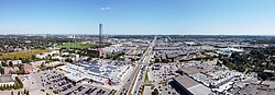
Today, little industrial uses exist on Eglinton Avenue, while some industrial uses remain off Eglinton on side streets. Around the year 2000, the south section of Eglinton development of the former van plant property was being redeveloped into a new trend at the time American style "big box" retail uses.

In 2014, the City of Toronto government and Metrolinx conducted a preplanning exercise called Eglinton Connects to create walkable, mixed-use developments along the Eglinton Crosstown LRT. One area for such development is the Golden Mile site between Victoria Park Avenue and Pharmacy Avenue, which will be served by two LRT stops. City planning officials said that, although there is weak demand for new condos in central Scarborough, the LRT is stimulating demand for development. [4]

Economy

List of businesses

Eglinton Square Shopping Centre is one of several shopping centres located in the Golden Mile. Eglinton Square.jpg
Eglinton Square Shopping Centre is one of several shopping centres located in the Golden Mile.

The Golden Mile is home to a number of shopping malls and plazas, including:

Golden Mile Mall

Golden Mile Plaza was added west of the industrial "mile" in 1954 and was visited in 1959 [5] by Queen Elizabeth II marking the further transformation of the area into a series of strip malls.

The original strip mall on the north of Eglinton Avenue was anchored by a Famous Players movie theatre located at Pharmacy Avenue and Eglinton. The west section of the strip was severely damaged by a fire in 1986, which hastened the beginning of the transformation of the area into one of Toronto's largest concentrations of power centres and big-box stores.

The plaza was replaced with the first Loblaws branded Super Store within Toronto and a few other retail stores. Its building was not a mall and was not comparable to the variety of retail stores and services it replaced. Other stores that were originally part of the strange design of the building were a Fabricland and a Zellers, which closed in the 2000s. The superstore was rebranded as a No Frills, and much later Toronto Employment and Social Services, popular retailer Joe Fresh (part of Loblaws), Fit 4 Less, and a dollar store became tenants in 2010, using space that Zellers and Fabricland had previously occupied.

In 2017, the property owner Choice Properties REIT announced a redevelopment of the 19-acre site into a mixed-use, transit-oriented development. It will include a mix of buildings of various heights and a new Loblaws supermarket. The development will create new streets surrounding nine city blocks and include a public park and a public square. The first phase will entail the construction of the new supermarket, the demolition of the existing mall, and the construction of new streets through the project. [6] This redevelopment is still in the proposal state, along with all other proposed redevelopment pending completion of the Golden Mile Secondary Plan Study. [7]

Institutions

The Toronto East Detention Centre is a remand centre operated by the provincial government. Toronto East Detention Centre.jpg
The Toronto East Detention Centre is a remand centre operated by the provincial government.

The Golden Mile is home to several services operated by the City of Toronto government, including the Toronto Public Library, whose Eglinton Square branch is located in the neighbourhood. The Government of Canada also operates several institutions in the neighbourhood, including a provincial courthouse, as well as the Toronto East Detention Centre. The Toronto East Detention Centre is a remand centre operated by the Ministry of Community Safety and Correctional Services.

Related Research Articles

<span class="mw-page-title-main">T&T Supermarket</span> Canadian supermarket chain

T&T Supermarkets is a Canadian supermarket chain that sells primarily Asian foods, including fresh produce, meat, seafood, and Asian packaged goods. It also sells kitchenware and gifts, and has in-store kitchens and bakeries. T&T Supermarkets was founded in Vancouver in 1993 by Cindy Lee. It is currently led by CEO Tina Lee, who succeeded her mother in 2014. In 2009, T&T Supermarkets was acquired by Loblaw Companies Limited.

<span class="mw-page-title-main">Malvern, Toronto</span> Neighbourhood in Toronto, Ontario, Canada

Malvern is a neighbourhood in the city of Toronto, Ontario, Canada, with a population of 44,315. It is located in the northeast corner of the city.

<span class="mw-page-title-main">Wexford, Toronto</span> Neighbourhood in Toronto, Ontario, Canada

Wexford is a neighbourhood in Toronto, Ontario, Canada. It is located in the eastern part of the city, on the western end of the district of Scarborough, spanning Lawrence Avenue East between Victoria Park Avenue and Birchmount Road. There are many persons of Greek heritage in this neighbourhood. The Wexford Heights Business Improvement Area boasts 245 members and hosts an annual street festival on Lawrence.

<span class="mw-page-title-main">Scarborough Southwest (federal electoral district)</span> Federal electoral district in Ontario, Canada

Scarborough Southwest is a federal electoral district in Toronto, Ontario, Canada, that has been represented in the House of Commons of Canada since 1968.

<span class="mw-page-title-main">Cancelled expressways in Toronto</span> Unbuilt freeways in Toronto, Canada

The cancelled expressways in Toronto were a planned series of expressways in Toronto, Ontario, Canada that were only partially built or cancelled due to public opposition. The system of expressways was intended to spur or handle growth in the suburbs of Toronto, but were opposed by citizens within the city of Toronto proper, citing the demolition of homes and park lands, air pollution, noise and the high cost of construction. The Spadina Expressway, planned since the 1940s, was cancelled in 1971 after being only partially constructed. After the Spadina cancellation, other expressway plans, intended to create a 'ring' around the central core, were abandoned.

<span class="mw-page-title-main">Eglinton Avenue</span> Road in Toronto and Mississauga, Canada

Eglinton Avenue is a major east–west arterial thoroughfare in Toronto and Mississauga in the Canadian province of Ontario. The street begins at Highway 407 at the western limits of Mississauga, as a continuation of Lower Baseline in Milton. It traverses the midsection of both cities and ends at Kingston Road. Eglinton Avenue is the only street to cross all six former cities and boroughs of Metropolitan Toronto.

<span class="mw-page-title-main">Empress Walk</span> Condominium and retail complex in Toronto, Ontario

Empress Walk is a large Canadian condominium and retail complex in Toronto, Ontario, Canada. It is located at the intersection of Yonge Street and Empress Avenue in the North York Centre area of the North York district It was developed by Canadian-developers Menkes Developments Ltd. Phase 1 was completed in 1997 and Phase 2 was completed in 2000. It became an important retail complex in North York following its construction.

<span class="mw-page-title-main">Flemingdon Park</span> Neighbourhood in Toronto, Ontario, Canada

Flemingdon Park is a neighbourhood in Toronto, Ontario, Canada, located in the city's North York district. It is part of the Don Valley East federal and provincial electoral districts, and Ward 26: Don Valley East (South) municipally. In 2011, its population was 22,205. The average income was $66,784.

<span class="mw-page-title-main">Erin Mills Town Centre</span> Shopping mall in Mississauga, Ontario, Canada

Erin Mills Town Centre is a shopping mall located in Erin Mills, Mississauga, Ontario, Canada, at the corner of Erin Mills Parkway and Eglinton Avenue West. It is the second largest mall in Mississauga, after Square One. The mall can be accessed from the 401, 403, and 407 series highways. Erin Mills Town Centre Bus Terminal is located directly at the back of the mall.

<span class="mw-page-title-main">Clairlea</span> Neighbourhood in Toronto, Ontario, Canada

Clairlea is a safe, quiet, middle to upper-middle income neighbourhood in Toronto, Ontario, Canada that features well treed streets and detached homes with large backyards. The neighbourhood is located in east Toronto just east of Victoria Park Avenue.

<span class="mw-page-title-main">Transit City</span> Proposed Toronto public transit plan

Transit City was a plan for developing public transport in Toronto, Ontario, Canada. It was first proposed and announced on 16 March 2007 by Toronto mayor David Miller and Toronto Transit Commission (TTC) chair Adam Giambrone. The plan called for the construction of seven new light rail lines along the streets of seven priority transit corridors, which would have eventually been integrated with existing rapid transit, streetcar, and bus routes. Other transit improvements outlined in the plan included upgrading and extending the Scarborough RT line, implementing new bus rapid transit lines, and improving frequency and timing of 21 key bus routes. The plan integrated public transportation objectives outlined in the City of Toronto Official Plan, the TTC Ridership Growth Strategy and Miller's 2006 election platform.

<span class="mw-page-title-main">Lawrence Allen Centre</span> Shopping mall in Toronto

The Lawrence Allen Centre, formerly Lawrence Square Shopping Centre, is a shopping centre located in Toronto, Ontario, Canada. Owned by RioCan, it is one of the city's twenty largest malls. It is located on Lawrence Avenue West, west of Allen Road, in the neighbourhood of Lawrence Heights, the district of North York. It is accessible from the Toronto Transit Commission's Lawrence West station, as well as via various bus routes. It is a terminating vista of Marlee Avenue. North of Lawrence Allen Centre is the Yorkdale Shopping Centre.

<span class="mw-page-title-main">Shoppers World Danforth</span>

Shoppers World Danforth is a hybrid shopping plaza and shopping mall in Toronto, Ontario, Canada. It has 40 stores serving parts of East York, Scarborough and The Beaches, near the Victoria Park subway station. Today a moderately sized suburban plaza, it has a notable place in history as one of the first suburban and one of the first enclosed malls in Canada. It is approximately 326,300 square feet (30,310 m2) in area.

<span class="mw-page-title-main">Eglinton Square</span> Shopping mall in Ontario, Canada

Eglinton Square Shopping Centre is an enclosed shopping mall in Toronto, Ontario, Canada, located at Eglinton Avenue East and Victoria Park Avenue in Scarborough's Golden Mile neighbourhood. It opened in 1953 as a strip plaza and was later converted to mall.

<span class="mw-page-title-main">Bayview Village Shopping Centre</span> Shopping mall in Toronto, Canada

Bayview Village Shopping Centre is a shopping mall in Toronto, Ontario, Canada. The 440,000-square-foot (41,000 m2) shopping mall is located at the northeast corner of Bayview Avenue and Sheppard Avenue in the former city of North York. It has a total of 110 stores, the anchor stores being Loblaws, Shoppers Drug Mart and LCBO.

<span class="mw-page-title-main">Forest Hill station (Toronto)</span> Future underground LRT station in Toronto, Canada

Forest Hill is an underground light rail transit (LRT) station under construction on Line 5 Eglinton, a new line that is part of the Toronto subway system. It will be located in the Forest Hill neighbourhood at the intersection of Bathurst Street and Eglinton Avenue. It is scheduled to open no earlier than 2024.

<span class="mw-page-title-main">O'Connor stop</span> Future LRT stop in Toronto, Canada

O'Connor is a surface light rail transit (LRT) stop under construction on Line 5 Eglinton, a new line that is part of the Toronto subway system. It will be located in the Golden Mile neighbourhood at the intersection of Eglinton Avenue and Victoria Park Avenue. It is scheduled to open in 2024.

References

  1. Dickson, Barbara (2015). Bomb Girls: Trading Aprons for Ammo. Toronto: Dundurn Press Limited. pp. 242–243. ISBN   9781459731165.
  2. Brown, Alan. "Scarborough's "Golden Mile"". Toronto Plaques. Archived from the original on July 14, 2014. Retrieved April 4, 2021.
  3. "General Motors and the Golden Mile". Read the Plaque. Retrieved April 4, 2021.
  4. John Lorinc (February 8, 2017). "New life for Eglinton Avenue East". The Globe and Mail . Retrieved February 11, 2017.
  5. Scarborough Archives
  6. "Choice Properties to redevelop block at Eglinton Crosstown". Daily Commercial News. January 12, 2017. p. 3.
  7. "Golden Mile Secondary Plan Study". September 7, 2017.

43°43′34″N79°17′17″W / 43.726°N 79.288°W / 43.726; -79.288