Crescent Town

Last updated

Crescent Town
Neighbourhood
Crescent Town 2022.jpg
Crescent Town's buildings
Crescent Town map.PNG
Position of Crescent Town
Coordinates: 43°41′45″N79°17′35″W / 43.69583°N 79.29306°W / 43.69583; -79.29306
CountryFlag of Canada (Pantone).svg  Canada
ProvinceFlag of Ontario.svg  Ontario
City Toronto
CommunityToronto & East York
Changed Municipality1998 Toronto from East York
Government
   MP Nathaniel Erskine-Smith (Beaches-East York)
   MPP Mary-Margaret McMahon (Beaches-East York)
   Councillor Brad Bradford (Ward 19) Beaches-East York)

Crescent Town is a neighbourhood in Toronto, Ontario, Canada, in the former borough of East York. It is located near Victoria Park Avenue and Danforth Avenue. It mainly consists of high-rise apartment complexes, built originally to take advantage of the opening of the adjacent Victoria Park subway station, which connects to the central quadrangle via a partially covered walkway.

Contents

History

In the late 19th century, Walter Massey (1864–1901), a younger son of Hart Massey, Canada's first major industrialist, and uncle to actor Raymond Massey, purchased a 240-acre (97 ha) country property centered on Dawes Road and Victoria Park Avenue. He established a model farm and named it "Dentonia Park" after his wife, Susan, whose maiden name was Denton.

The Massey farm sold fresh eggs and poultry as well as fresh trout, which was caught in the many streams and rivulets that criss-crossed the farm. The Massey farm was also the home of the City Dairy Company Limited, which produced the first pasteurized milk in Canada.

In 1933, Susan Massey donated her mansion and 40 acres (16 ha) of the Dentonia farm land to Crescent School, where her grandsons were educated. [1] [2] Crescent School operated at the Dentonia site until 1969, when this property was sold to the developers who built the present-day Crescent Town neighbourhood.

Current status

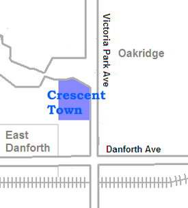
Crescent Town is considered by some as an interesting experiment in community planning in that all of its pedestrian walkways are located above the street level. It is a multicultural neighbourhood, whose population includes extensive numbers of Bangladeshi, Indian, Jamaican, Pakistani and Tamil Canadians. There are many Bangladeshi-owned businesses near the neighbourhood (Victoria Park-Danforth).

Some of the buildings are condominiums (Massey Square), while others are rental apartments (Crescent Place). Toronto council classified Oakridge under Taylor-Massey as a neighborhood improvement area in 2014. [3]

Related Research Articles

<span class="mw-page-title-main">Riverdale, Toronto</span> Neighbourhood in Toronto, Ontario, Canada

Riverdale is a large neighbourhood in Toronto, Ontario, Canada. It is bounded by the Don River Valley to the west, Danforth Avenue and Greektown to the north, Jones Avenue, the CN/GO tracks, Leslieville to the east, and Lake Shore Boulevard to the south.

<span class="mw-page-title-main">Downsview</span> Neighbourhood in Toronto, Ontario, Canada

Downsview is a neighbourhood in the north end of Toronto, Ontario, Canada, located in the district of North York. The area takes its name from the Downs View farm established around 1842 near the present-day intersection of Keele Street and Wilson Avenue. It now extends beyond the intersection of Sheppard Avenue and Dufferin Street, though it is popularly seen as including the areas to the north right up to the Toronto city limit at Steeles Avenue. The area includes several large post-World War II subdivisions. Within the area is Downsview Airport, the former site of Canadian Forces Base Downsview, which has since been largely converted following the end of the Cold War into an urban park known as Downsview Park. The airport is still used as a manufacturing and testing facility for Bombardier Aerospace.

<span class="mw-page-title-main">Victoria Park station (Toronto)</span> Toronto subway station

Victoria Park is a station on Line 2 Bloor–Danforth of the Toronto subway system. It is located at 777 Victoria Park Avenue, one block north of Danforth Avenue in Scarborough. The station can be accessed by pedestrians directly from Victoria Park Avenue; by way of an unmanned entrance from Albion Avenue; through an automated entrance from Teesdale Place; and via a walkway that leads to the nearby Crescent Town area. A City of Toronto bicycle station is located adjacent to the main Victoria Park Avenue entrance, providing a paid secure indoor bicycle parking area.

<span class="mw-page-title-main">Golden Mile, Toronto</span> Commercial district in Ontario, Canada

The Golden Mile is a commercial district in the Scarborough district of Toronto, Ontario, Canada. Situated along Eglinton Avenue East, east of Victoria Park Avenue, it was one of Canada's first model industrial parks. The original Golden Mile of Industry ran along Eglinton from Pharmacy Avenue east to Birchmount Road.

<span class="mw-page-title-main">Crescent School (Toronto)</span> Day school in Toronto, Ontario, Canada

Crescent School is an independent elementary and secondary boys' school in Toronto, Ontario, Canada. It teaches boys from Grades 3 to 12. Established in 1913 by John William James, the school was situated in several locations during its early years.

<span class="mw-page-title-main">Playter Estates</span> Neighbourhood in Toronto, Ontario, Canada

Playter Estates is an area in the east end of Toronto, Ontario, Canada bounded by Jackman Avenue to the east, the Don River Valley to the west, Danforth Avenue in the south, and Fulton Avenue in the north. The neighbourhood is built on land once owned by the Playter family for whom two streets in the area are named. The old farmhouse of the Playter household at 28 Playter Crescent is now the Playter Mansion, which is often used for various films, television shows, and commercials.

<span class="mw-page-title-main">Eringate-Centennial-West Deane</span> Neighbourhood in Toronto, Ontario, Canada

Eringate-Centennial-West Deane is a neighbourhood in the city of Toronto, Canada. Eringate-Centennial-West Deane borders the city of Mississauga.

<span class="mw-page-title-main">O'Connor–Parkview</span> Neighbourhood in Toronto, Ontario, Canada

O'Connor–Parkview is a neighbourhood in the East York area of Toronto, Ontario, Canada. While the name is taken from the definition used by the city of Toronto, local residents are more familiar with the niche areas that define the larger neighbourhood. It is a very diverse neighbourhood that includes English-speakers and Greeks in the west, to the Tamil speakers in the east and Bengali people in the south. It includes low-income highrises, to huge property lots. The smaller areas included inside the neighbourhood are Topham Park, Woodbine Gardens and Parkview Hills.

<span class="mw-page-title-main">Old East York</span> Neighbourhood in Toronto, Ontario, Canada

Old East York is a district of the city of Toronto, Ontario, Canada. It consists of the southern, urban, portion of the former borough of East York. Old East York is continuous and functionally integrated with the old City of Toronto, bounded by the old municipal boundary between East York and Old Toronto on the south, by the Don River Valley on the west and northwest, by Taylor-Massey Creek on the north, and Victoria Park Avenue in the east.

<span class="mw-page-title-main">Tam O'Shanter-Sullivan</span> Neighbourhood in Toronto, Ontario, Canada

Tam O'Shanter-Sullivan is a neighbourhood in the east end of the city of Toronto, Ontario, Canada, in the district of Scarborough. The neighbourhood is bordered by Huntingwood Drive to the North, Kennedy Road to the East, Highway 401 to the South and Victoria Park to the West. The neighbourhood, which includes the Tam O'Shanter and Sullivan communities, takes its name from Tam O’Shanter Golf Course and O'Sullivan's Corners.

<span class="mw-page-title-main">Oakridge, Toronto</span> Neighbourhood in Toronto, Ontario, Canada

Oakridge is a neighbourhood in the city of Toronto, Canada, in the Scarborough district. The community neighbours Birch Cliff to the south, Danforth Village to the east and Cliffside to the west edging onto the Scarborough Bluffs. The neighbourhood is bordered by Victoria Park Avenue to the west, Massey Creek to the north, Warden Avenue to the east travelling south until Mack Avenue which then extends east again to the CNR rail line which forms the southern border.

<span class="mw-page-title-main">Ashbridge Estate</span> Historic estate in Toronto, Ontario, Canada

The Ashbridge Estate is a historic estate in eastern Toronto, Ontario, Canada. The property was settled by the Ashbridge family, who were English Quakers who left Pennsylvania after the American Revolutionary War. In 1796, as United Empire Loyalists, the family were granted 600 acres (240 ha) of land on Lake Ontario east of the Don River, land which they had begun clearing two years earlier.

<span class="mw-page-title-main">Upper Beaches</span> Neighbourhood in Toronto, Ontario, Canada

The Upper Beaches is a neighbourhood in Toronto, Ontario, Canada. It is directly north of the Beaches area. It stretches from Coxwell Avenue in the west to Victoria Park in the east. The southern border is Kingston Road, while the northern boundary is generally considered to be the Canadian National Railway tracks between Gerrard Street and Danforth Avenue. The western part of the area was originally called Norway, and the larger area was once part of the Town of East Toronto. The name "Upper Beaches" was first used by developers and real estate agents around the period of 2001 to 2003 for the selling of houses on redeveloped land in the area, and was used as a marketing tag to attract buyers. The area was never considered part of the Beaches neighbourhood but was close to it. The city's current name for this area is East End Danforth, though that is rarely used. The city also includes the buildings along and just north of Danforth Avenue in the neighbourhood. The western portion between Woodbine Avenue and Coxwell is referred to by the city as Woodbine Corridor.

<span class="mw-page-title-main">High Park North</span> Neighbourhood in Toronto, Ontario, Canada

High Park North, or often simply High Park, after the park, is a neighbourhood in Toronto, Ontario, Canada. It is bounded on the south by Bloor Street, on the west by Runnymede Road, on the north by Annette Street, Quebec Avenue and Humberside Avenue, and on the east by the GO Transit Weston Subdivision rail tracks. It is located in the Parkdale—High Park provincial and federal electoral districts. The area east of Keele Street is also known informally as the "West Bend" neighbourhood.

<span class="mw-page-title-main">East Danforth</span> Neighbourhood in Toronto, Ontario, Canada

East Danforth, also known as Danforth Village, is a neighbourhood in the east end of Toronto, Ontario, Canada. It is located on the eastern part of Danforth Avenue in the old city of Toronto. It stretches from the eastern edge of Greektown by Greenwood Avenue to the boundary of Scarborough at Victoria Park Avenue. The area is covered by two business improvement associations, Danforth Village and Danforth Mosaic. To the north of the neighbourhood is Old East York, once a separate municipality, but today closely integrated into the area. The southern border is the railway tracks, beyond which is Leslieville and the Upper Beaches. According to the 2006 census the area has a population of 14,629.

<span class="mw-page-title-main">Birch Cliff</span> Neighbourhood in Toronto, Ontario, Canada

Birch Cliff is a neighbourhood in Toronto, Ontario, Canada. It is located in the eastern part of the city, part of the district of Scarborough running along the shore of Lake Ontario atop the western part of the Scarborough Bluffs. Birch Cliff has a large Irish population. About one-third of Birch Cliff residents are of Irish origin.

City Dairy Company Limited was a dairy company founded by Walter Edward Massey, president of Massey-Harris, to deliver milk in the city of Toronto. The company was the first Canadian dairy to supply pasteurized milk.

References

  1. "Dentonia Park, later Crescent School" . Retrieved March 29, 2021.
  2. "Crescent School history" . Retrieved March 29, 2021.
  3. "311 Knowledge Base". www.toronto.ca.