Cabbagetown, Toronto

Last updated
Cabbagetown
Neighbourhood
Toronto Cabbage Town 1 (8437347293).jpg
Houses in Cabbagetown
Toronto map.png
Red pog.svg
Location within Toronto
Coordinates: 43°39′59″N79°21′46″W / 43.6664°N 79.3629°W / 43.6664; -79.3629 Coordinates: 43°39′59″N79°21′46″W / 43.6664°N 79.3629°W / 43.6664; -79.3629
CountryCanada
Province Ontario
City Toronto
Government
  TypeWard 13 of Toronto City Council
   City councillor Chris Moise

Cabbagetown is a neighbourhood in central Toronto, Ontario, Canada. Administratively, it is defined as part of the Cabbagetown-South St. Jamestown neighbourhood. [1] It largely features semi-detached Victorian houses and is recognized as "the largest continuous area of preserved Victorian housing in all of North America", according to the Cabbagetown Preservation Association.

Contents

Cabbagetown's name derives from the Irish immigrants who moved to the neighbourhood beginning in the late 1840s, said to have been so poor that they grew cabbage in their front yards. [2] Canadian writer Hugh Garner's novel, Cabbagetown, depicted life in the neighbourhood during the Great Depression.

History

The area today known as Cabbagetown was first known as the village of Don Vale, just outside Toronto. Before the 1850s it consisted of farmland dotted with cottages and vegetable plots. It grew up in the 1840s around the Winchester Street Bridge, which before the construction of the Prince Edward Viaduct was the main northern bridge over the Don River. [3] This was near the site where Castle Frank Brook flowed in the Don River. By the bridge the Don Vale Tavern and Fox's Inn were established to cater to travellers. [4] In 1850 the Toronto Necropolis was established in the area as the city's main cemetery.

Brick Victorian styled homes were built throughout Cabbagetown in the late 19th and early 20th century. Cabbagetown houses.jpg
Brick Victorian styled homes were built throughout Cabbagetown in the late 19th and early 20th century.
Francis Shields House built in 1877 by Bruce and Hagon Inc. Francis Shields House, 377 Sackville St., Toronto, 1876-77, Bruce and Hagon Architects-1.jpg
Francis Shields House built in 1877 by Bruce and Hagon Inc.

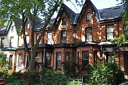
In the late 19th century the area was absorbed into the city. It became home to the working class Irish inhabitants who were employed in the industries along the lake shore to the south in Corktown. Brick Victorian-style houses were built throughout the area. The name Cabbagetown purportedly came from stories of new Macedonian and Irish immigrants digging up their front lawns and planting cabbage. In this era the Cabbagetown name most often applied to the area south of Gerrard Street, with the part to the north still being called Don Vale. It was a working-class neighbourhood, with approximately 50% of the residents renting houses. [5] It reached its peak of prosperity just before the First World War, which is from when many of the brick homes in the area date. The various architectural styles visible in the neighborhood range from Second-Empire to Bay-n-Gable and High Victorian Terraces, with excellent examples being Francis Shields' House at 377 Sackville St. [6]

After the war the area became increasingly impoverished. A large number of poorer residents moved in, many resorting to share one house among multiple families. The nineteenth-century brick houses began deteriorating and, as landlords saw less value in the neighbourhood, they were not maintained. [7] It became known as one of Toronto's largest slums and much of the original Cabbagetown was razed in the late 1940s to make room for the Regent Park housing project. A new immigrant influx also lead to the beginning of ethnic diversity in the neighbourhood. The remaining section to the north, then still known as Don Vale, was also slated to be cleared and replaced by housing projects. In 1964 a Toronto Star writer wrote that "Cabbagetown has become a downhill ride and if you're on way up, you don't dare stay there for long unless you live in Regent Park." [8]

The construction of new housing projects was halted in the 1970s. In Don Mount this effort was led by Karl Jaffary, who was elected to city council in the 1969 municipal election along with a group of like-minded councillors who opposed sweeping urban renewal plans. John Sewell led the effort to preserve Trefann Court, which covered the southern section of the original Cabbagetown. A bylaw was approved in the 1970s to ban any building higher than four storeys, in reaction to the high density high-rises being built in neighbouring St. James Town. [9]

Gentrification

Businesses along Carlton Street. CabbagetownStreetscape.jpg
Businesses along Carlton Street.

Cabbagetown was gentrified by affluent professionals, beginning in the 1970s. Many residents restored small Victorian row houses and became community activists. Darrell Kent, a resident and local businessman, is recognized by the community as having been the driving force behind the restoration of many of the area’s beautiful and unique Victorian houses. [10] As Kent was a gay real estate agent, gay men and some lesbians made up the earliest gentrifying groups of Cabbagetown. [9] They are still a significant part of the population today, and the area is considered queer friendly.

In 1983 the Globe and Mail wrote, [11]

Cabbagetown is probably the epitome of successful labelling. The core of the area—generally defined as being bounded by Parliament, Wellesley and Dundas Streets and the Don Valley[ citation needed ]—was once Toronto's skid row. Today, about a decade after the area was invaded by young professionals, speculators and real estate agents, there are still a few derelicts around to give the area colour. The houses, meanwhile, sell for upward of $200,000.

35 years after that article was written, most homes in the area sell for well over $1 million.

Vestiges of a 1960s, counter-culture ambiance remain at vintage clothing stores, health food stores and a gestalt therapy clinic. A Victorian farm, once the site of a zoo, is located adjacent to Riverdale Park West, where a weekly farmer's market is held. A short distance away is the Cabbagetown Youth Centre, home of the Cabbagetown Boxing Club, a reminder of an earlier, and rougher, past. In recent years, some businesses from the nearby "gay village" of Church and Wellesley, have relocated to the area, attracted by cheaper commercial rents.

Despite gentrification, residents from public housing projects and affluent home owners mingle at a discount supermarket and a community medical clinic. Panhandling and drug-dealing are part of the urban landscape; so are gourmet shops, upscale boutiques and arts festivals, book launches and wine-tastings at local restaurants. Paradoxically, [12]

The Gerrard and Parliament neighbourhood, located near Dundas and Sherbourne Streets, has the largest concentration of homeless shelters and drop-in centres in Canada. The area is also distinguished by a large number of rooming houses and other forms of low-income housing.

Residents and notable people

The neighbourhood is home to many artists, musicians, journalists and writers. Other residents include professors, doctors and social workers, many affiliated with the nearby University of Toronto and the many hospitals on University Avenue. Proximity to the financial district and downtown core have also made the area popular with other professionals such as lawyers, management consultants and those in financial services.[ citation needed ]

Celebrities who have at some time been residents of Cabbagetown include:

As part of a project called "Cabbagetown People," historical plaques have been placed on noteworthy homes. A map of the locations has been erected in Riverdale Park West, and an index of the addresses, with the names of the former residents, is posted on a website devoted to this project. The people listed include:

See also

Related Research Articles

<span class="mw-page-title-main">Regent Park</span> Neighbourhood in Toronto, Ontario, Canada

Regent Park is a neighbourhood located in downtown Toronto, Ontario built in the late 1940s as a public housing project managed by Toronto Community Housing. It sits on what used to be a significant part of the Cabbagetown neighbourhood and is bounded by Gerrard Street East to the north, River Street to the east, Shuter Street to the south and Parliament Street to the west. Regent Park's residential dwellings, prior to the ongoing redevelopment, were entirely social housing and covered all of the 69 acres (280,000 m²) which comprise the community. The original neighbourhood was razed in the process of creating Regent Park. The nickname Cabbagetown is now applied to the remaining historical, area north and west of the housing project, which has experienced considerable gentrification since the 1960s and 1970s.

<span class="mw-page-title-main">Rosedale, Toronto</span> Neighbourhood in Toronto, Ontario, Canada

Rosedale is a neighbourhood in central Toronto, Ontario, Canada. It was formerly the estate of William Botsford Jarvis, and so named by his wife, granddaughter of William Dummer Powell, for the wild roses that grew there in abundance. It is located north of Downtown Toronto and is one of its oldest suburbs. It is also one of the wealthiest and most highly priced neighbourhoods in Canada. Rosedale has been ranked the best neighbourhood in Toronto to live in by Toronto Life. It is known as the area where the city's 'old money' lives, and is home to some of Canada's richest and most famous citizens including Gerry Schwartz, founder of Onex Corporation, Adrienne Clarkson, the 26th Governor General of Canada, and her husband, the author John Ralston Saul, as well as David Thomson, 3rd Baron Thomson of Fleet of the Thomson Corporation, the latter of whom is the richest man in Canada.

<span class="mw-page-title-main">The Beaches</span> Neighbourhood in Toronto, Ontario, Canada

The Beaches is a neighbourhood in Toronto, Ontario, Canada. It is so named because of its four beaches situated on Lake Ontario. It is located east of downtown within the "Old" City of Toronto. The approximate boundaries of the neighbourhood are from Victoria Park Avenue on the east to Kingston Road on the north, along Dundas Street to Coxwell Avenue on the west, south to Lake Ontario. The Beaches is part of the east-central district of Toronto.

John Sewell is a Canadian politician and lawyer who served as the 58th mayor of Toronto from 1978 to 1980.

Leslieville is a neighbourhood in Toronto, Ontario, Canada, situated east of the Don River. It is bounded by the Canadian National railway line and Gerrard Street to the north, McGee Street to the west, Eastern Avenue to south, and Coxwell Avenue to the east.

<span class="mw-page-title-main">Kensington Market</span> Neighbourhood in Toronto, Ontario, Canada

Kensington Market is a distinctive multicultural neighbourhood in Downtown Toronto, Ontario, Canada. The Market is an older neighbourhood and one of the city's most well-known. In November 2006, it was designated a National Historic Site of Canada. Robert Fulford wrote in 1999 that "Kensington today is as much a legend as a district. The (partly) outdoor market has probably been photographed more often than any other site in Toronto."

<span class="mw-page-title-main">Riverdale, Toronto</span> Neighbourhood in Toronto, Ontario, Canada

Riverdale is a large neighbourhood in Toronto, Ontario, Canada. It is bounded by the Don River Valley to the west, Danforth Avenue and Greektown to the north, Jones Avenue, the CN/GO tracks, Leslieville to the east, and Lake Shore Boulevard to the south.

<span class="mw-page-title-main">Gerrard Street (Toronto)</span> Thoroughfare in Toronto, Ontario

Gerrard Street is a street in Toronto, Ontario, Canada. It consists of two separate parts, historically referred to as Lower Gerrard and Upper Gerrard. The former stretches between University Avenue and Coxwell Avenue for 6 km, across Old Toronto. The latter portion starts 300 m north of Lower Gerrard's eastern terminus and runs between Coxwell Avenue and Clonmore Drive, between Victoria Park Avenue and Warden Avenue, in Scarborough for another 4 km.

Hugh Garner was a British-born Canadian novelist.

<span class="mw-page-title-main">Bayview Village</span> Neighbourhood in Toronto, Ontario, Canada

Bayview Village is an affluent neighbourhood in Toronto, Ontario, Canada. It is part of the federal Don Valley North riding and the provincial Don Valley North electoral district, and Toronto electoral Ward 17: Don Valley North. In 2006, it had a population of 15,370.

<span class="mw-page-title-main">Garden District, Toronto</span> Neighbourhood in Toronto, Ontario, Canada

The Garden District is a neighbourhood in downtown Toronto, Ontario, Canada. The name was selected by the Toronto East Downtown Residents Association (TEDRA) in recognition of Allan Gardens, an indoor botanical garden located nearby at the intersection of Carlton and Jarvis Streets. The Garden District was officially designated by the Mayor and Toronto City Council in 2001, while TEDRA has since been renamed the Garden District Residents Association. Part of the neighbourhood is within official City of Toronto neighbourhood of Moss Park.

<span class="mw-page-title-main">Old Toronto</span> Dissolved city in Ontario, Canada

Old Toronto is an administrative district and the retronym of the area within the original city limits of Toronto, Ontario, Canada, from 1834 to 1998. It was first incorporated as a city in 1834, after being known as the town of York, and became part of York County. Toronto periodically grew in size by annexing adjacent land.

<span class="mw-page-title-main">Moss Park</span> Neighbourhood in Toronto, Ontario, Canada

Moss Park is a residential neighbourhood located in downtown Toronto, Ontario, Canada. The area known as Moss Park is typically considered to be between Jarvis Street and Parliament Street, south of Dundas Street, an area dominated by public housing projects. According to one set of boundaries of the City of Toronto, it is roughly L-shaped, bounded on the north by Carlton Street to Parliament Street, on the east by Parliament Street to Queen Street East and the Don River, on the south by Eastern Avenue and Front Street, and on the west by Jarvis Street. This larger concept of the area includes the neighbourhoods known as Corktown and the Garden District, as well as a portion of Cabbagetown.

<span class="mw-page-title-main">Architecture of Toronto</span> Overview of the architecture of Toronto

The architecture of Toronto is an eclectic combination of architectural styles, ranging from 19th century Georgian architecture to 21st century postmodern architecture and beyond.

<span class="mw-page-title-main">Parliament Street (Toronto)</span> Street in Toronto, Ontario, Canada

Parliament Street is a north-south street in the eastern part of downtown Toronto, Ontario, Canada. The street runs from Bloor Street to Queens Quay and is the first major street west of the Don River.

<span class="mw-page-title-main">History of neighbourhoods in Toronto</span>

Throughout its history, Toronto has been a city divided into many districts and neighbourhoods. As the city has grown, new neighbourhoods have been created by expansion of the city into the countryside. Over time, the neighbourhoods within existing areas have also been altered and rearranged.

<span class="mw-page-title-main">Trefann Court</span> Neighbourhood in Canada, Ontario, Toronto

Trefann Court is a small neighbourhood in the eastern part of downtown Toronto, Ontario, Canada. It is located on the north side of Queen Street between Parliament Street and River Street. It extends north only a short distance to Shuter St.

<span class="mw-page-title-main">George Street, Toronto</span> Street in Toronto, Ontario, Canada

George Street is a north–south street in Toronto, Ontario, Canada, from south of Front Street, north to Gerrard Street. Its southern blocks are within the grid of the townsite of the original town of York, Upper Canada. George Street was once one of the most exclusive and expensive addresses in the city. Today, the north end of the street, next to Seaton House men's shelter, is an example of urban blight. The City of Toronto government is redeveloping the street with a new Seaton House institution focused more on long-term care. Several abandoned buildings have been bought by the city, and others have been expropriated to facilitate the redevelopment – the George Street Revitalization Project.

Farewell Oak Street is a Canadian docudrama short film, directed by Grant McLean and released in 1953. Narrated by Lorne Greene as part of the Canada Carries On series, the film centres on Toronto's late-1940s demolition of the run-down Oak Street neighbourhood in Cabbagetown in favour of the new Regent Park housing development, through a mixture of documentary footage of the reconstruction with a dramatization of the story of a family whose lives are transformed for the better by the project. The cast of the dramatic segments includes Roxanna Bond, Bonnie Brooks, Gerald Campbell, Eric Clavering, Andy Halmay, Cosie Lee, Edgar Marshall, Douglas Masters, Jim McRae and Kate Reid.

References

  1. " Archived 2014-12-15 at the Wayback Machine " Toronto Neighborhoods List
  2. "" a view on cities
  3. "Don Vale House" Lost Rivers
  4. Charles Sauriol Remembering the Don: a rare record of earlier times within the Don River Valley. Dundurn Press Ltd., 1981
  5. Cruickshank, Tom (2008). Old Toronto Homes. Richmond Hill, Canada: Firefly Books. p. 167. ISBN   978-1-55407-382-5.
  6. Cruickshank, Tom. Old Toronto Homes. p. 172.
  7. Careless, J. M. S.. "Emergence of Cabbagetown in Victorian Toronto." Careless at work selected Canadian historical studies. Toronto: Dundurn Press, 1990. 309-315. Print.
  8. Coreilli, Rae. "Cabbages on the Front Lawn, that was Toronto in 1900." Toronto Star. February 15, 1964. p. 1
  9. 1 2 Fumia, Dureen. "Divides, High Rise and Boundaries: A Study of Toronto's Downtown East Side Neighbourhood", Ethnologies 32.0 2010. Retrieved on 14 December 2014
  10. "Darrell Kent". Archived from the original on 2011-07-06. Retrieved 2010-08-12.
  11. "Labelling the neighborhood." Yves Lavigne. The Globe and Mail. Nov 17, 1983. pg. CL.5
  12. http://www.metrac.org/wp-content/uploads/2014/06/gerrard.parliament.jan08.pdf Safety Audit Report Card –Gerrard Street East and Parliament Street – Ward 27; Audit conducted on 29 January 2008
  13. Gains, Larry (1976) The Impossible Dream, Leisure Publications Ltd, 14 Fleet Street, London EC4
  14. "Opening up the Tombs". ottawaxpress.ca . Archived from the original on 2009-03-05. Retrieved 2007-10-28.
  15. "Tonetta - Part 2 - the Artist in Their Own Words (Tonetta Interview)". YouTube .
  16. "NOAH RICHLER: Whacking come-from-aways with taxes is such feckless folly for Nova Scotia | SaltWire".

Further reading