Scarborough City Centre

Last updated

Scarborough City Centre
Neighbourhood
Scarborough City Centre.JPG
High rise buildings at Scarborough City Centre
Scarborough City Centre map.PNG
Coordinates: 43°46′22″N79°15′27″W / 43.77278°N 79.25750°W / 43.77278; -79.25750
CountryFlag of Canada (Pantone).svg  Canada
ProvinceFlag of Ontario.svg  Ontario
City Toronto
Changed Municipality1998 Toronto from Scarborough
Government
   MP Salma Zahid (Scarborough Centre)
   MPP Christina Mitas (Scarborough Centre)
   Councillor Michael Thompson (Ward 21 Scarborough Centre)

Scarborough City Centre is a commercial district in Toronto, Ontario, Canada. It was the central business district for the former city of Scarborough, which amalgamated with Toronto in 1998. Scarborough City Centre remains one of the central business districts outside Downtown Toronto.

Contents

Character

Scarborough Civic Centre and Albert Campbell Square are located at the centre of Scarborough City Centre. Scarborough Civic Centre7.jpg
Scarborough Civic Centre and Albert Campbell Square are located at the centre of Scarborough City Centre.

It is roughly bounded by Kennedy Road and Dorset Park to the west, Markham Road and Woburn to the east, Ellesmere Road and Bendale to the south, and Ontario Highway 401/Agincourt to the north. At its centre core is the Scarborough Civic Centre, Albert Campbell Square, Scarborough Town Centre shopping mall, and the Canada Centre Building.

Condominium high-rises surround these central buildings and public spaces, forming the skyline of the neighbourhood. The major office towers in the area include those situated at Consilium Place, which was completed in 1991. In a band around the southern side of the city centre are densely forested parklands, between Borough Drive and Ellesmere Road. The areas outside the immediate city centre is primarily made up of industrial parks, and low-density housing.

History

Prior to the 1940s, the area was primarily agricultural, with the closest communities being Agincourt and Malvern. Early farms in the area included the farm of George and Lena Bick, who founded the Bick's Pickle brand from pickles grown and processed on their farm. Although the farm was eventually converted to residential and industrial land, the production facility continued to operate on Progress Avenue until 2001. [1]

Built in 1841, Scott House was a former residence located in Scarborough City Centre. The building was later converted into a restaurant. Scott House Scarborough.jpg
Built in 1841, Scott House was a former residence located in Scarborough City Centre. The building was later converted into a restaurant.

Development in the area had first come in the 1950s when Ontario Highway 401 was built through the area. One early development was the TV studios of CFTO-TV at the intersection of the 401 and McCowan Road. Scarborough became part of Metropolitan Toronto in 1954 when "Metro" was carved out of York County. As part of the metropolitan government’s planning policy, plans were put forth to develop the city centres of municipalities surrounding the City of Toronto, which originated as rural townships rather than distinct urban settlements. Scarborough Civic Centre, which was built to house offices of Scarborough's municipal government, and Metropolitan Toronto, and the Scarborough Town Centre were built in the 1970s. The Toronto Transit Commission's Scarborough RT line was completed in 1985.

The beginning of the 21st century saw the development of several condominium high-rises and office complexes in the area.

The area was formerly represented as Ward 38 Scarborough Centre, in the 44 Ward city council model. However in 2018, a 25 Ward model was adopted, resulting in Wards 38 and 37 merging to create Ward 21 Scarborough Centre. [2]

In December 2018, plans by Oxford Properties and AECOM were unveiled, proposing massive changes to the City Centre area. Specifically between McCowan Road, Brimley Road and the 401. The proposal includes the realignment of Progress Avenue around the Scarborough Town Centre, the introduction of 36 new residential buildings to the area, and brand new park spaces. [3] [4]

Transportation

A train from Line 3 Scarborough between McCowan station and Scarborough Centre station. Scarborough RT between Scarborough Centre and McCowan.jpg
A train from Line 3 Scarborough between McCowan station and Scarborough Centre station.

The neighbourhood is connected to public transit services at operated by the Toronto Transit Commission (TTC). Scarborough Centre station is the primary station of the city centre, used by the TTC bus system, and Line 3 Scarborough trains. In addition to Scarborough Centre station, two other stations from Line 3 Scarborough are situated in Scarborough Centre, Midland station is a station west of Scarborough Centre, situated along the centre's western boundary, while McCowan station is situated east of Scarborough Centre station, and acts as the line's terminus. Line 3 will be demolished and in its place, Line 2 Bloor-Danforth will be extended, relocating Scarborough Centre station by 2029–30. Once extended, Line 2 will provide a one-seat ride to Downtown Toronto from Scarborough City Centre. [5]

In addition to municipal transit, the Scarborough Centre Bus Terminal is a commuter bus service operated by GO Transit bus services. In addition to GO Transit, the terminal is also used by several inter-city coach services. The Scarborough Centre station and the Scarborough Centre Bus Terminal are situated adjacent to one another, next to the Scarborough Town Centre and Scarborough Civic Centre.

The neighbourhood is bounded by Ontario Highway 401, a major east-west controlled access highway that bisects the City of Toronto.

See also

Related Research Articles

<span class="mw-page-title-main">Line 3 Scarborough</span> Defunct light rapid transit line in Toronto, Canada

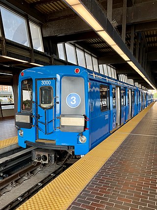
Line 3 Scarborough, originally known as Scarborough RT (SRT), was a light rapid transit line that was part of the Toronto subway system in Toronto, Ontario, Canada. The line ran entirely within the eastern district of Scarborough, encompassing six stations and 6.4 kilometres (4.0 mi) of mostly elevated track. It connected with Line 2 Bloor–Danforth at its southwestern terminus, Kennedy, and terminated in the northeast at McCowan. In 2022, the system had a ridership of 4,720,000, or about 12,300 per weekday as of the third quarter of 2023.

<span class="mw-page-title-main">Scarborough, Ontario</span> District of Toronto, Ontario, Canada

Scarborough is a district of Toronto, Ontario, Canada. It is situated atop the Scarborough Bluffs in the eastern part of the city. Its borders are Victoria Park Avenue to the west, Steeles Avenue and the city of Markham to the north, Rouge River and the city of Pickering to the east, and Lake Ontario to the south. Scarborough was named after the English town of Scarborough, North Yorkshire, inspired by its cliffs.

<span class="mw-page-title-main">Agincourt, Toronto</span> Neighbourhood in Toronto, Ontario, Canada

Agincourt is a neighbourhood and former village in Toronto, Ontario, Canada. Agincourt is located in northeast Toronto, along Sheppard Avenue between Kennedy and Markham Roads. Before the creation of the "megacity" of Toronto in 1998, the area was part of Scarborough. It is officially recognized by the City of Toronto as occupying the neighbourhoods of Agincourt South–Malvern West and Agincourt North.

<span class="mw-page-title-main">Malvern, Toronto</span> Neighbourhood in Toronto, Ontario, Canada

Malvern is a neighbourhood in the city of Toronto, Ontario, Canada, with a population of 44,315. It is located in the northeast corner of the city.

<span class="mw-page-title-main">Scarborough Centre station</span> Toronto subway station

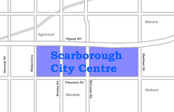
Scarborough Centre is a bus terminal in Toronto, Ontario, Canada, serving multiple bus routes of the Toronto Transit Commission (TTC) and one Durham Regional Transit (DRT) bus route. It was also a rapid transit station serving Line 3 Scarborough of the Toronto subway system until Line 3's closure on July 24, 2023. It is located north of Ellesmere Road between Brimley and McCowan Roads, just south of Highway 401. It was adjacent to the former Scarborough Centre Bus Terminal, which was a station for GO Transit buses and other intercity coach services until the TTC modified the facility for TTC buses.

<span class="mw-page-title-main">McCowan station</span> Toronto subway station

McCowan was a terminal station on Line 3 Scarborough of the Toronto subway. The closed station is located at 1275 McCowan Road, just north of Ellesmere Road at Bushby Drive/Town Centre Court.

<span class="mw-page-title-main">Eglinton Avenue</span> Road in Toronto and Mississauga, Canada

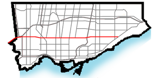
Eglinton Avenue is a major east–west arterial thoroughfare in Toronto and Mississauga in the Canadian province of Ontario. The street begins at Highway 407 at the western limits of Mississauga, as a continuation of Lower Baseline in Milton. It traverses the midsection of both cities and ends at Kingston Road. Eglinton Avenue is the only street to cross all six former cities and boroughs of Metropolitan Toronto.

<span class="mw-page-title-main">Brimley Road</span> Thoroughfare in Toronto, Ontario

Brimley Road is a north-south street in Toronto and the Regional Municipality of York, Ontario, Canada. In Toronto, it is located entirely within Scarborough and carried 32000 vehicles daily in May 2007 Hence, it is classified as a major arterial road by the city of Toronto.

<span class="mw-page-title-main">Scarborough Town Centre</span> Shopping mall in Ontario, Canada

Scarborough Town Centre (STC) is a shopping mall in Toronto, Ontario, Canada. Central to the Scarborough City Centre district, it is adjacent to Scarborough Centre station, the Scarborough Centre Bus Terminal and the CTV Toronto studios (9 Channel Nine Court). Opened in 1973, the mall is the fourth largest shopping mall in Canada and third in Toronto by retail space.

<span class="mw-page-title-main">Richview, Toronto</span> Neighbourhood in Toronto, Ontario, Canada

Richview, formally known as Willowridge-Martingrove-Richview, is a neighbourhood in the city of Toronto, Ontario, Canada. It is bounded on the west by Highway 401 and on the north by the highway and by Dixon Road, Royal York Road on the east, and Eglinton Avenue West along the south. Richview was originally established as a postal village within the then-agricultural Etobicoke Township, which later became the suburb of Etobicoke.

<span class="mw-page-title-main">Clanton Park, Toronto</span> Neighbourhood in Toronto, Ontario, Canada

Clanton Park is a neighbourhood in Toronto, Ontario, Canada. Located in the district of North York, it is part of federal and provincial electoral district York Centre, and Toronto electoral wards 9: York Centre (West) and 10: York Centre (East). In 2016, it had a population of 16,472, a 12.7% rise from 2011.

<span class="mw-page-title-main">Steeles, Toronto</span> Neighbourhood in Toronto, Ontario, Canada

Steeles is a suburban neighbourhood in Toronto, Ontario, Canada. Steeles is located in the north-eastern part of Toronto in the former suburb of Scarborough. To the north is bordered by Steeles Avenue East, to the east by Kennedy Road, to the south by a hydro-electric transmission line and to the west by Victoria Park Avenue.

<span class="mw-page-title-main">Woburn, Toronto</span> Neighbourhood in Toronto, Ontario, Canada

Woburn is a neighbourhood located in eastern Toronto, Ontario, Canada, in the former suburb of Scarborough. Woburn is bordered by Highway 401 to the north, Orton Park Road to the east, Lawrence Avenue to the south, and McCowan Road to the west.

The Eglinton East LRT (EELRT), also known as Line 7 Eglinton East and formerly known as the Scarborough Malvern LRT, is a proposed light rail line in Toronto, Ontario, Canada. The line would be entirely within the district of Scarborough. It was originally part of Transit City, a plan to develop new light rail lines along several priority transit corridors in the city.

MoveOntario 2020 was a 2007 plan proposed by the Government of Ontario that would fund 52 rapid-transit projects throughout the Greater Toronto and Hamilton Area in Ontario, Canada. It was succeeded by The Big Move and GO Transit's Go 2020.

<span class="mw-page-title-main">Highland Creek, Toronto</span> Neighbourhood in Toronto, Ontario, Canada

Highland Creek is a neighbourhood in eastern Toronto, Ontario, Canada. It is located along the southern portion of the river of the same name in the former suburb of Scarborough. To the east are the neighbourhoods of Port Union and West Rouge, to the west West Hill and Woburn, and to the south Centennial Scarborough.

<span class="mw-page-title-main">Scarborough Centre Bus Terminal</span> Bus station in Toronto, Ontario, Canada

Scarborough Centre Bus Terminal is a regional and intercity bus terminal in Scarborough City Centre in Toronto, Ontario, Canada, located near its namesake rapid transit station on Line 3 Scarborough of the Toronto subway. It is served by GO Transit buses. The terminal is near the Scarborough Town Centre shopping mall and the Scarborough Civic Centre. Until 2022, Megabus, and other private coach services used the terminal, but have moved to temporary on-street locations nearby due to subway construction.

West Highland Creek is a river in Toronto, Ontario, Canada, and is a tributary of Highland Creek in the Lake Ontario drainage basin. The creek and its tributaries are entirely within the old City of Scarborough, and provide the watershed for the northwest of the city.

Durham–Scarborough bus rapid transit (DSBRT) is a future bus rapid transit corridor proposed by Metrolinx for the eastern part of the Greater Toronto Area in Southern Ontario, Canada. The 36-kilometre (22 mi) bus corridor will run from downtown Oshawa to Scarborough Town Centre in Toronto, mainly along Durham Region Highway 2 in Durham Region and Ellesmere Road in the Scarborough district of Toronto. Dedicated bus lanes will be used where feasible. Buses of the Toronto Transit Commission, Durham Region Transit and GO Transit would use the busway. Metrolinx has indicated that the BRT could be easily converted to LRT in the future if required.

References

  1. "Bick's Pickles". cooksinfo.com.
  2. Patton, Jessica (October 23, 2018). "Toronto election 2018: Ward 21 Scarborough Centre". Globalnews.ca. Retrieved January 8, 2019.
  3. O'Neil, Lauren (December 11, 2018). "Huge changes could be coming to Scarborough Town Centre". blogTO. Retrieved January 8, 2019.
  4. Mirabelli, Julian (December 10, 2018). "Docs Hint at Massive Scarborough Town Centre Redevelopment". Urban Toronto. Retrieved January 8, 2019.
  5. "Scarborough Subway Extension". Metrolinx. Retrieved 19 June 2020.