Downtown Yonge

Last updated

Coordinates: 43°39′20.5″N79°22′50.3″W / 43.655694°N 79.380639°W / 43.655694; -79.380639

Geographic coordinate system Coordinate system

A geographic coordinate system is a coordinate system that enables every location on Earth to be specified by a set of numbers, letters or symbols. The coordinates are often chosen such that one of the numbers represents a vertical position and two or three of the numbers represent a horizontal position; alternatively, a geographic position may be expressed in a combined three-dimensional Cartesian vector. A common choice of coordinates is latitude, longitude and elevation. To specify a location on a plane requires a map projection.

Contents

Yonge-Dundas Square at night looking west towards the Toronto Eaton Centre Dundas Sqaure.JPG
Yonge-Dundas Square at night looking west towards the Toronto Eaton Centre

Downtown Yonge is a retail and entertainment district centred on Yonge Street in Downtown Toronto, Ontario, Canada. The Downtown Yonge district is bounded by Richmond Street to the south; Grosvenor and Alexander Streets to the north; Bay Street to the west; and portions of Church Street, Victoria Street, and Bond Street to the east. All property owners and commercial tenants within these boundaries are members of the Downtown Yonge Business Improvement Area association, founded in 2001.

Yonge Street road from shores of Lake Ontario in Toronto to Lake Simcoe

Yonge Street is a major arterial route in the Canadian province of Ontario connecting the shores of Lake Ontario in Toronto to Lake Simcoe, a gateway to the Upper Great Lakes. Until 1999, the Guinness Book of World Records repeated the popular misconception it was 1,896 km (1,178 mi) long, and thus the longest street in the world; this was due to a conflation of Yonge Street with the rest of Ontario's Highway 11. Yonge Street is actually 56 kilometres (35 mi) long. The construction of Yonge Street is designated an Event of National Historic Significance in Canada. Yonge Street was fundamental in the original planning and settlement of western Upper Canada in the 1790s, forming the basis of the concession roads in Ontario today. Once the southernmost leg of Highway 11, linking the capital with northern Ontario, Yonge Street has been referred to as "Main Street Ontario". Today, no section of Yonge Street is a provincial highway.

Downtown Toronto human settlement in Canada

Downtown Toronto is the city centre and main central business district of Toronto, Ontario, Canada. Located entirely within the district of Old Toronto, it is approximately 14 square kilometers in area, bounded by Bloor Street to the north, Lake Ontario to the south, the Don Valley to the east, and Bathurst Street to the west. It is also the governmental centre of the City of Toronto and the Province of Ontario.

Toronto Provincial capital city in Ontario, Canada

Toronto is the provincial capital of Ontario and the most populous city in Canada, with a population of 2,731,571 in 2016. Current to 2016, the Toronto census metropolitan area (CMA), of which the majority is within the Greater Toronto Area (GTA), held a population of 5,928,040, making it Canada's most populous CMA. Toronto is the anchor of an urban agglomeration, known as the Golden Horseshoe in Southern Ontario, located on the northwestern shore of Lake Ontario. A global city, Toronto is a centre of business, finance, arts, and culture, and is recognized as one of the most multicultural and cosmopolitan cities in the world.

History

The district has been a busy shopping district for over 100 years. While the original shopping street of Toronto was King Street east of Yonge, the noteworthy development of the area into a shopping district was the opening and expansion of the T. Eaton store at Yonge and Queen Street.

King Street (Toronto) thoroughfare in Toronto, Ontario, Canada

King Street is a major east–west commercial thoroughfare in Toronto, Ontario, Canada. It was one of the first streets laid out in the 1793 plan of the town of York, which became Toronto in 1834. After the construction of the Market Square in 1803 at King and Jarvis streets, to house the first St. Lawrence Market farmer's market, the street became the primary commercial street of York and early Toronto. This original core was destroyed in the 1849 Great Fire of Toronto, but subsequently rebuilt. The original street extended from George to Berkeley Street and was extended by 1901 to its present terminuses at Roncesvalles Avenue in the west and the Don River in the east.

The shopping district began to develop in 1869, with the opening of the first Eaton's store on Yonge Street. Original Eaton's store.jpg
The shopping district began to develop in 1869, with the opening of the first Eaton's store on Yonge Street.

The store eventually grew to encompass over three city blocks on the west side of Yonge, used for ancillary stores and factories of the Eaton company. Across Queen Street from the Eaton store, the Robert Simpson department store grew to encompass the entire south-east corner block of Yonge and Queen. The Simpson store exists today as the Hudson's Bay Company store. North of Dundas Street, a landmark store was opened by Sam Sniderman called Sam the Record Man, which offered three floors of records.

Hudsons Bay Company Canadian retail business group

The Hudson's Bay Company is a Canadian retail business group. A fur trading business for much of its existence, HBC now owns and operates retail stores in Canada, the United States, and parts of Europe including Belgium, the Netherlands, and Germany. The company's namesake business division is Hudson's Bay, commonly referred to as The Bay. Other divisions include Galeria Kaufhof, Home Outfitters, Lord & Taylor and Saks Fifth Avenue. HBC's head office is currently located in Brampton, Ontario. The company is listed on the Toronto Stock Exchange under the symbol "HBC".

Sam Sniderman Canadian entrepreneur, philanthropist, started music retailing company "Same the Record Man." Member of the Order of Canada.

Sam Sniderman, was a Canadian businessman best known as the founder of the Canadian record shop chain Sam the Record Man. Sniderman was also a major promoter of Canadian music including involvement in pushing for the Canadian content (CANCON) broadcast regulations and creating the Juno Awards.

Sam the Record Man

Sam the Record Man was a Canadian record store chain that, at one time, was Canada's largest music recording retailer. In 1982, its ads proclaimed that it had "140 locations, coast to coast".

As the retail usage developed, so did entertainment uses. Massey Hall was built just to the east of Yonge Street on Shuter, along with the Pantages and Wintergarden theatres on Yonge between Dundas and Queen Street. Massey Hall remains mostly in the state that it was when it opened, while the two theatres were both converted into movie houses, then reconverted back into live theatre venues.

Ed Mirvish Theatre theatre and cinema in Toronto, Ontario, Canada

The Ed Mirvish Theatre is a historic film and play theatre in Downtown Toronto, Ontario, Canada. It was initially known as the Pantages Theatre, then became the Imperial Theatre and later the Canon Theatre, before it was renamed in honour of Ed Mirvish, a well-known businessman and theatre impresario. The theatre was first opened in 1920 and is located near Yonge-Dundas Square.

Starting in the 1960s, the T. Eaton Company made plans to redevelop its lands on the west side of Yonge Street. This eventually became the genesis of today's Toronto Eaton Centre. The Eaton store was moved to Yonge and Dundas, and is today the Sears store. All of the west side of Yonge Street from Queen to Dundas was demolished and the mall built. Only the Holy Trinity Church and the Old City Hall remain of the pre-Eaton Centre buildings from Dundas to Queen, from Yonge to Bay remain.

Church of the Holy Trinity (Toronto) Church

The Church of the Holy Trinity is an Anglican church in downtown Toronto, Ontario, Canada at Trinity Square.

Old City Hall (Toronto) building in Toronto

The Old City Hall is a Romanesque civic building and court house in Toronto, Ontario, Canada. It was the home of the Toronto City Council from 1899 to 1966 and remains one of the city's most prominent structures. The building is located at the corner of Queen and Bay Streets, across Bay Street from Nathan Phillips Square and the present City Hall in the Downtown Toronto. The heritage landmark has a distinctive clock tower which heads the length of Bay Street from Front Street to Queen Street as a terminating vista.

Attractions

The Downtown Yonge area is best known as the home of the Toronto Eaton Centre indoor mall, Toronto’s largest and most visited tourist attraction. Adjacent to the mall, at the corner of Yonge and Dundas Street is Yonge-Dundas Square, a large public square. The area is well known for shopping, including music retailers, mid-priced fashion stores, and jewelers.

Opened in 1894, Massey Hall is a performing arts theatre and a major attraction in Downtown Yonge. Massey Hall August 2017 02.jpg
Opened in 1894, Massey Hall is a performing arts theatre and a major attraction in Downtown Yonge.

The district is home to a number of performance venues including the Canon Theatre, the Carlu, the Elgin and Winter Garden Theatres, Massey Hall and the Zanzibar Tavern. The area’s heritage properties include such notable sites as the Arts & Letters Club, Mackenzie House, Maple Leaf Gardens, Old City Hall and the demolished Sam the Record Man store.

Business Improvement Area

The Downtown Yonge district is a registered business improvement area, known as the Downtown Yonge Business Improvement Area. The 2,000 businesses and property owners of the area are members of the Downtown Yonge Business Improvement Area Association (BIA). There is a volunteer Board that sets the strategic direction of the association. The Board has fourteen seats, which includes twelve members of the association and two City of Toronto representatives, specifically the local City Councillor (Kyle Rae). There is a committee structure that reports to the Board and a small number of staff and service providers who implement the association’s initiatives. [1]

The focus of the BIA association is on key areas that include clean streets, safe streets, social improvement, streetscape improvements, and marketing. Some of the most notable initiatives include:

-Clean Streets Team – A full-time street cleaning team, hired by the Downtown Yonge is responsible for graffiti removal, poster removal, litter sweeping, and sidewalk pressure washing. The crew supplements the work of the City and has been operating since January 2002.

-Police Foot Patrols – A dedicated presence of police foot patrol officers add to the safety of Downtown Yonge streets. Improvements have been made in such areas as street crime, drugs, and illegal vending. The Downtown Yonge B.I.A. hires the officers to supplement the existing levels of policing in the area. The program has been operating since April 2002.

-Social Improvement – Businesses, social service agencies, the City of Toronto, and other community interests are working together to expand outreach support to the homeless in the Downtown Yonge area, equip businesses with tools to deal with situations, and advocating for long term solutions.

-Holiday Openings – The Downtown Yonge area is the first district in Toronto to be officially designated a tourist area. This allows retailers the option of legally opening on statutory holidays. The area realized this status in June 2002.

-Streetscape Improvements – The identity and sense of place in Downtown Yonge is being enhanced through traffic poles that are branded with the association’s logo at major Yonge Street intersections. Holiday decorations suspended above Yonge Street add to the festive atmosphere of the district annually in November and December.

-Discovery Team – A mobile ambassador program during the summer months was launched in May 2005. A multi-lingual group of trained visitors services personnel help the public meet their business, shopping, and entertainment needs in the Downtown Yonge area.

People boarding a streetcar from the 505 Dundas line in Downtown Yonge. The streetcar line is one of three lines that passes through Downtown Yonge. Dundas Street streetcar.jpg
People boarding a streetcar from the 505 Dundas line in Downtown Yonge. The streetcar line is one of three lines that passes through Downtown Yonge.

Transportation

The area is served by the Toronto Transit Commission’s Queen, Dundas, and College subway stations, as well as the Yonge bus and 501 Queen, 505 Dundas, and 506 Carlton street car routes.

Related Research Articles

Yonge–Dundas Square square

Yonge–Dundas Square, or Dundas Square, is a public square at the southeast corner of the intersection of Yonge Street and Dundas Street East in Downtown Toronto, Ontario, Canada. Designed by Brown and Storey Architects, the square was conceived in 1997 as part of revitalizing the intersection. Since its completion in 2002, the square has hosted many public events, performances and art displays, establishing itself as a prominent landmark in Toronto and one of the city's prime tourist attractions. Central to the Downtown Yonge entertainment and shopping district, the square is owned by the city and is the first public square in Canada to be maintained through a public-private partnership. The intersection is one of the busiest in Canada, with over 100,000 people crossing the city's first pedestrian scramble daily.

Toronto Eaton Centre shopping mall and office complex in downtown Toronto, Ontario, Canada

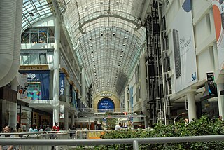
The Toronto Eaton Centre is a shopping mall and office complex in Downtown Toronto, Ontario, Canada. It is owned and managed by Cadillac Fairview (CF). It was named after the Eaton's department store chain that once anchored it before the chain became defunct in the late 1990s.

Eatons

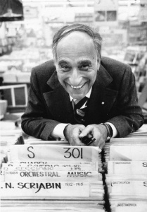
The T. Eaton Company Limited, commonly known as Eaton's, was a Canadian retailer that was once Canada's largest department store chain. It was founded in 1869 in Toronto by Timothy Eaton, a Presbyterian Ulster Scot immigrant from what is now Northern Ireland. Eaton's grew to become a retail and social institution in Canada, with stores across the country, buying-offices around the globe, and a catalogue that was found in the homes of most Canadians. A changing economic and retail environment in the late 20th century, along with mismanagement, culminated in the chain's bankruptcy in 1999.

Chinatown, Toronto Neighbourhood in Toronto, Ontario, Canada

Toronto Chinatowns are ethnic neighbourhoods in and around Toronto, Ontario, Canada, with a high concentration of ethnic Chinese residents and businesses. There are multiple Chinatowns in Toronto and the Greater Toronto Area.

Queen Street (Toronto) thoroughfare in Toronto, Ontario

Queen Street is a major east-west thoroughfare in Toronto. The western section begins at the intersection of Roncesvalles Avenue and King Street, where The Queensway continues it west. It extends eastward in a straight line to Yonge Street where it becomes Queen Street East, from there is extend eastwards until after Victoria Park Avenue near the R. C. Harris Water Treatment Plant; the road is covered by Toronto Transit Commission route 501 Queen, and some sections are covered by the 502 Downtowner. The centre lanes each way have streetcar, although like many Toronto streets, cars are generally permitted in these lanes.

PATH (Toronto) network of pedestrian tunnels in Toronto

PATH is a network of underground pedestrian tunnels, elevated walkways, and at-grade walkways connecting the office towers of Downtown Toronto, Ontario, Canada. It is more than 30 kilometres (19 mi) long. According to Guinness World Records, PATH is the largest underground shopping complex in the world with 371,600 square metres (4,000,000 sq ft) of retail space.

Dundas station (Toronto) Toronto subway station

Dundas is a subway station on Line 1 Yonge–University in Toronto, Ontario, Canada. It is located at the intersection of Yonge Street and Dundas Street. Wi-Fi service is available at this station.

Bloordale Village human settlement in Canada

Bloordale Village is a Business Improvement Area (BIA) that is located along Bloor Street from Lansdowne Avenue to Dufferin Street, west of downtown in Toronto, Ontario, Canada. It sits on the southern border of the Wallace Emerson neighbourhood and the northern border of the Brockton Village neighbourhood. The district is home to a mix of shopping, bars and vintage clothing, book, and video stores. There are also many, many furniture stores.

Dundas Street major arterial road in southwestern Ontario

Dundas Street, is a major historic arterial road in Ontario, Canada. The road connects the city of Toronto with its western suburbs and several cities in southwestern Ontario. Three provincial highways—2, 5, and 99—followed long sections of its course, although these highway segments have since been downloaded to the municipalities they passed through. Originally intended as a military route to connect the shipping port of York to the envisioned future capital of London, Ontario, the street today connects Toronto landmarks such as Yonge-Dundas Square and the city's principal Chinatown to rural villages and the regional centres of Hamilton and London.

504 King streetcar line in Toronto, Canada

The 504 King is an east–west streetcar route in Toronto, Ontario, Canada. It serves King Street in Downtown Toronto as well as Broadview Avenue on the east end and Roncesvalles Avenue on the west end of the line. The route consists of two overlapping branches: 504A between Dundas West station and Distillery Loop, and 504B Broadview station and Dufferin Gate Loop. The two branches overlap on King Street between Dufferin and Sumach streets, both passing St. Andrew station and King station on subway Line 1 Yonge–University.

Garden District, Toronto Neighbourhood in Toronto, Ontario, Canada

The Garden District is a neighbourhood in downtown Toronto, Ontario, Canada. The name was selected by the Toronto East Downtown Residents Association (TEDRA) in recognition of Allan Gardens, an indoor botanical garden located nearby at the intersection of Carlton and Jarvis Streets. The Garden District was officially designated by the Mayor and Toronto City Council in 2001, while TEDRA has since been renamed the Garden District Residents Association. Part of the neighbourhood is within official City of Toronto neighbourhood of Moss Park.

College Park (Toronto) shopping mall, residential and office complex in Toronto, Ontario

College Park is a shopping mall, residential and office complex on the southwest corner of Yonge Street and College Street in Toronto, Ontario, Canada. An Art Deco landmark, the building was built between 1928 and 1930 by the Eaton's department store, and was designed by Ross and Macdonald, the Montreal architectural firm that also designed the Royal York Hotel and Maple Leaf Gardens in Toronto, the Château Laurier Hotel in Ottawa, and the Montreal Eaton's store.

Eaton Centre Wikimedia disambiguation page

Eaton Centre is a name associated with shopping malls in Canada, originating with Eaton's, one of Canada's largest department store chains at the time that these malls were developed. Eaton's partnered with development companies throughout the 1970s and 1980s to develop downtown shopping malls in cities across Canada. Each mall contained an Eaton's store, or was in close proximity to an Eaton's store, and typically the mall itself carried the "Eaton Centre" name. These joint ventures were a significant retail development trend in Canada during that period.

Atrium on Bay retail and office complex in Toronto, Canada

Atrium is a large 1,000,000 square feet (93,000 m2) retail and office complex in Toronto, Ontario, Canada. Atrium is located adjacent to the highly popular Yonge-Dundas Square, and was built upon the former site of the former Ford Hotel Toronto, on the north side of Dundas Street West, extending from Yonge Street to Bay Street. The mixed-use building was constructed in 1981 with parking on the second and third underground levels and retail space street and concourse levels topped by an eight-storey office block that rises to 14 floors on the east end of the site and 13 on the west. As part of downtown Toronto's PATH network, Atrium's Concourse Level is directly connected underground to the Dundas subway station, the Toronto Eaton Centre south, across on Dundas Street, and the Toronto Coach Terminal located west, across Bay Street.

Eatons Annex

Located on Albert Street, directly behind the Eaton's Main Store and Toronto's City Hall, the Eaton's Annex was a 10-storey building containing both retail and office space. By 1900, the Eaton's department store owned almost all of the lands within the city blocks bordered by Yonge Street, Queen Street West, Bay Street and Dundas Street, and the land was occupied by the Eaton's Main Store, the Annex building and various Eaton's warehouses and mail order buildings. The Main Store and the Annex, however, were the only two buildings open to the public. In 1900, the two buildings were connected by an underground passageway open to both employees and shoppers. It was the first underground pathway in Toronto open to the public, and is often credited as a historic precursor to Toronto's current downtown PATH network.

Thornton–Smith Building

The Thornton–Smith Building, located at 340 Yonge Street, is a prominent heritage building in the heart of downtown Toronto, Ontario, Canada. Since the completion of the building in the twenties, Yonge Street has seen many transformations and while tenants in the building have reflected these changes The Thornton–Smith Building itself has remained true to its original architecture.

References

  1. "About Downtown Yonge - Board". Downtown Yonge Business Improvement Association. Archived from the original on 2007-10-14. Retrieved 2009-09-30.