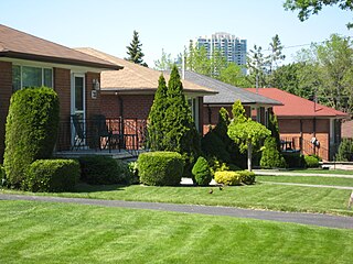
Bendale, also called Cedarbrae and Midland Park, is a residential neighbourhood in the eastern part of Toronto, Ontario, Canada. It is located in the former suburb of Scarborough. It is centred on the intersection of Lawrence Avenue East and Brimley Road. Its boundaries, as defined by the City, are Midland Avenue from Lawrence, north to Highway 401, east to McCowan, south to Lawrence, east to West Highland Creek, south-west along West Highland Creek, then follow several side streets parallel to the Creek, north to Midland Avenue. The area north of Ellesmere is typically considered the Scarborough City Centre district, and is not considered in this neighbourhood article.

Downsview is a neighbourhood in the north end of Toronto, Ontario, Canada, located in the district of North York. The area takes its name from the Downs View farm established around 1842 near the present-day intersection of Keele Street and Wilson Avenue. It now extends beyond the intersection of Sheppard Avenue and Dufferin Street, though it is popularly seen as including the areas to the north right up to the Toronto city limit at Steeles Avenue. The area includes several large post-World War II subdivisions. Within the area is Downsview Airport, the former site of Canadian Forces Base Downsview, which has since been largely converted following the end of the Cold War into an urban park known as Downsview Park. The airport is still used as a manufacturing and testing facility for Bombardier Aerospace.

Newtonbrook is a neighbourhood in Toronto, Ontario, Canada. It is located in the area around Yonge Street and Finch Avenue in the district of North York between the east and west branches of the Don River. Officially, the area is divided into two neighbourhoods; Newtonbrook West and Newtonbrook East.
Willowdale is a neighbourhood in the city of Toronto, Ontario, Canada, located in the district of North York. It developed from three postal villages: Newtonbrook, Willowdale and Lansing.

Lawrence Heights is a neighbourhood in Toronto, Ontario, Canada. It is located north-west of central Toronto, in the district of North York. The neighbourhood is roughly bounded by Lawrence Avenue to the south, Yorkdale Road to the north, Varna Drive to the east and Dufferin Street to the west. It is part of the greater Yorkdale-Glen Park official Toronto neighbourhood.

Humber Summit is a neighbourhood in Toronto, Ontario, Canada. It is one of the northernmost neighbourhoods in Toronto, located in the North York district of the city. It is bounded by Steeles Avenue to the north, Highway 400 to the east, Finch Avenue to the south, and follows the Humber River to the west.

Pelmo Park-Humberlea is a neighbourhood in Toronto, Ontario, Canada. It is located north-west of the central core, in the former suburb of North York. Many of the neighbourhoods in this quadrant of the city can aptly be described as family neighbourhoods with access to parks, green space and a slower pace than found closer to downtown.

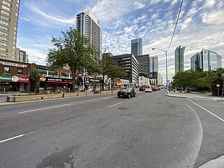
York University Heights, also known as Northwood Park, is a neighbourhood in Toronto, Ontario, Canada. It is one of Toronto's northernmost neighbourhoods, located along the northern boundary of Steeles Avenue in the former city of North York. The neighbourhood is so named because it contains the main campus of York University. This area is most popular with immigrants of Italian and Chinese descent who have established communities in the area. It is located between Sheppard Avenue and Steeles Avenue east of Black Creek.
Amesbury or Brookhaven-Amesbury is a neighbourhood in Toronto, Ontario, Canada. The neighbourhood is located in northern Toronto in the former suburb of North York. It is part of federal and provincial electoral district York South—Weston, and Toronto electoral wards 11: York South—Weston (West) and 12: York South—Weston (East).

Lawrence Manor is a neighbourhood in the city of Toronto, Ontario, Canada. This neighbourhood is bounded by Bathurst Street on the east, Highway 401 to the north, the Allen to the west, and Lawrence Avenue to the south. The western side of the area borders along Bathurst Heights and the large public housing project.

Clanton Park is a neighbourhood in Toronto, Ontario, Canada. Located in the district of North York, it is part of federal and provincial electoral district York Centre, and Toronto electoral wards 9: York Centre (West) and 10: York Centre (East). In 2006, it had a population of 13,035.

Westminster-Branson is a neighbourhood in the city of Toronto, Ontario, Canada. It is in the northernmost part of the city within the area of North York.

Lansing is a neighbourhood in Toronto, Ontario, Canada. It originated as a minor settlement of a store, other services and a post office at the corner of Yonge Street and Sheppard Avenue and later became absorbed into the former suburb of North York. A larger area was designated as the postal village of Lansing. The City of Toronto labels it as Lansing-Westgate for neighbourhood planning purposes with the boundaries Yonge Street to the east, Highway 401 to the south, Bathurst Street to the west and Burnett Avenue to the north.

Pleasant View is a neighbourhood in the city of Toronto, Ontario, Canada that is located in the district of North York at the northern end of the city. It is bordered by Victoria Park to the East, Sheppard Avenue to the South, Highway 404 to the west and the Finch hydro corridor to the north. The neighbourhood is home to several high-rise apartment and condominium buildings, such as The Clippers.

Don Valley Village is a neighbourhood in the city of Toronto, Ontario, Canada. It is located in the former suburb of North York. Located north of Highway 401 and bisected by Don Mills Road, it is bounded by Sheppard Avenue to the south, Leslie Street to the west, Finch Avenue to the north and Highway 404 to the east. Like the nearby Don River Valley, the neighbourhood has hill and dale topography.

Dufferin Grove is a neighbourhood located in Toronto, Ontario, Canada, west of downtown. The neighbourhood is bordered by Bloor Street West to the north, Ossington Ave to the east, College Street to the south, and Dufferin Street to the west.
Morningside Heights is a residential neighbourhood in Toronto, Ontario, Canada. It is located in the northeast corner of the city, in the district of Scarborough, just north of the neighbourhood of Malvern and west of Rouge Park and the Rouge. The subdivision, comprising approximately 750 acres (3.0 km2), was one of the last large tracts of undeveloped land within the City of Toronto, located between Finch Avenue East and Steeles Avenue East, from Tapscott Road to the Rouge River.

Maple Leaf is a neighbourhood in the city of Toronto, Ontario, Canada. It is located in the southwest of the North York district. Its approximate borders are Lawrence Avenue to the south, Culford Road to the west, Highway 401 to the north, and the CNR rail lines east of Keele Street to the east.
Armour Heights is a neighbourhood in Toronto, Ontario, Canada, in the district of North York. It is bounded by Wilson Avenue to the south, Bathurst Street to the west, and the west branch of the Don River to the north and east. Highway 401 cuts through the centre of the neighbourhood.

Ledbury Park is a neighbourhood in Toronto, Ontario, Canada. It is located in the southern part of the North York area, just across the border from Midtown Toronto. Its boundaries are Avenue Road to the east, Lawrence Avenue to the south, Bathurst Street to the West, and Wilson Avenue and Highway 401 to the north.


