| Landmark | Cross street | Notes | Image |
|---|
| Sanctuary Park Cemetery | Royal York Road | Opened 1927 and merged from Riverside Cemetery and Westside Cemeteries in 1977. | 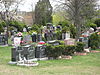 |
| St. Philip Anglican Church | Royal York Road | | 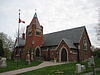 |
| Weston GO Station | Weston Road | Opened in 1974 as part of Georgetown Line, it has become a stop along the Union Pearson Express route to Toronto Pearson International Airport in 2015. Nearby was once CPR Weston Station. |  |
| CIBC 750 Lawrence | Dufferin Street | major computer centre, credit card call centre and head office operations built in 1980s | 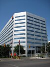 |
| Lawrence Allen Centre | Allen Road | Former RS Simpson Limited warehouse from the 1950s to 1970s, current mall opened in 1980s. Formerly Lawrence Square Shopping Centre. | 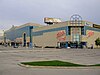 |
| Lawrence West subway station | Allen Road | The station lacks internal art work found on Line 1 Yonge–University, but found on exterior wall on the north side of south station. Opened 1978. | 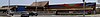 |
| John Polanyi Collegiate Institute | Allen Road/Allen Expressway | formerly Bathurst Heights Secondary School after being used by Toronto Catholic District School Board (TCDSB) for Dante Alighieri Academy Beatrice Campus and temporary home for Brebeuf College School; built in 1955 for North York Board of Education, building was vacant from 2001 to 2002. | 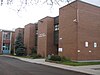 |
| Lawrence Plaza | Bathurst Street | One of the earliest shopping plazas in Toronto built in 1950s | |
| Havergal College | Avenue Road | Private and independent girls school moved to current site in 1926. |  |
| Lawrence Park Collegiate Institute | Avenue Road | Public high school opened in 1936 for Toronto Board of Education (now with Toronto District School Board) | 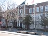 |
| Lawrence subway station | Yonge Street | Underground bus loop with counter to the normal traffic directions, opened in 1973 |  |
| Toronto French School | Bayview Avenue | Private and independent French school housed in Sifton Manor, former home of Sir Clifford Sifton from 1922 to 1947 and acquired by school in 1972. |  |
| Glendon College, York University | Bayview Avenue | Situated in the former home of Edward Rogers Wood built in 1924 and sold 1950; home to York University since 1966. | 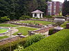 |
| Edwards Gardens | Leslie Street | Name for former mill operator Rupert E. Edwards opened in 1956 a Metro Toronto owned park |  |
| Shops at Don Mills | Don Mills Road | Formerly Don Mills Centre which was demolished in 2006. |  |
| Don Mills Collegiate Institute | Don Mills Road | Public high school opened in 1959 for North York Board of Education (now with Toronto District School Board) | 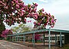 |
| Wexford Heights United Church | Warden Avenue | Zion Wexford United Church built 1842 with additions in 1956 and 1961 added |  |
| St. Lawrence Martyr Catholic Church | Birchmount Road | Opened 1959 | 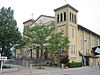 |
| Winston Churchill Collegiate Institute | Kennedy Road | Open 1953 for Township of Scarborough and Scarborough Board of Education (now with Toronto District School Board) | 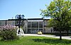 |
| Pizza Nova | Kennedy Road | Pizzeria franchised restaurant opened in 1963, original operates as Nova Ristorante | |
| Lawrence East RT station | Kennedy Road | Opened in 1985 and will be closed in the 2020s when line re-built. |  |
| Thomson Memorial Park | Brimley Road | Named after Scarborough's first European (Scottish) born pioneer family and opened in 1960. | 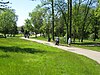 |
| Scarborough General Hospital | McCowan Road | Opened 1956 | 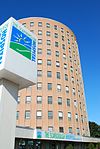 |
| St. Rose of Lima Catholic Church | McCowan Road | | 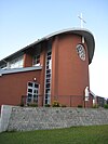 |
| Cedarbrae Mall | Markham Road | Outdoor strip plaza opened in 1962 and later enclosed. | 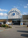 |
| St. Stephen's Presbyterian Church | Scarborough Golf Club Road | Built 1962 and replaced the former Golf Club Road Presbyterian Church | 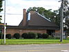 |
| Sir Oliver Mowat Collegiate Institute | Centennial Road | Public high school opened 1969 for Scarborough Board of Education (now with Toronto District School Board) |  |
| Rouge Hill GO Station | Eastern Avenue | Station opened in 1967 and upgraded with current station infrastructure and was in what was once part of Pickering. |  |
| Rouge National Urban Park | Rouge Hill Drive | The largest urban protected area in North America. Lawrence Ave East ends at the driveway to the Rouge Beach portion of the park, with a beach on the shoreline of Lake Ontario. The Waterfront Trail along the lakeshore provides pedestrian and bicycle access to Pickering. |  |


