Jarvis Street

Last updated

Jarvis Street

Jarvis St map.png
Jarvis Street (red)
Ted Rogers Way (pink)
Jarvis From Lower Jarvis Bridge.jpg
Morning traffic at Jarvis and Front in 2008
Route information
Maintained by City of Toronto government
Length3.2 km [1]  (2.0 mi)
Major junctions
South end Queens Quay
Major intersections
North end Mount Pleasant Road / Ted Rogers Way
Location
Country Canada
Province Ontario
Highway system
  • Roads in Toronto
Nearby arterial roads
  Yonge Street
Jarvis Street
Sherbourne Street  

Jarvis Street is a north-south thoroughfare in downtown Toronto, Ontario, Canada, passing through some of the oldest developed areas in the city. Its alignment extends from Queens Quay East in the south to Bloor Street in the north. The segment south of Front Street is known as "Lower Jarvis Street" while the segment from Bloor Street to Mount Pleasant Road is known as "Ted Rogers Way".

Contents

The street is a mix of older buildings dating back to the 1800s, including St. Lawrence Market, and has a large proportion of recent condominium apartment buildings. The street is considered by traffic engineers as an important artery to carry commuter traffic before and after work hours. To this end, a reversible lane was built in the mid-20th century along much of its length to allocate lanes. As well, Mount Pleasant Road was extended south to Jarvis and an intersection to the Gardiner Expressway was constructed. The City of Toronto initiated a redevelopment of the street in the early 2000s that widened sidewalks, added cycling lanes and removed the reversible lane. After less than two years, a subsequent City government removed the cycling lanes to nearby Sherbourne Street and the reversible lane was reinstated.

Ted Rogers Way

Ted Rogers Way

Route information
Maintained by City of Toronto government
Length0.16 km [2]  (0.099 mi; 520 ft)
ExistedDecember 2, 2009–present
Major junctions
South endJarvis Street / Mount Pleasant Road
North end Bloor Street
Location
Country Canada
Province Ontario
Highway system
  • Roads in Toronto

Ted Rogers Way is a north-south road in downtown Toronto, Ontario, Canada. It is the northern portion of Jarvis Street.

On December 2, 2009 the north portion of Jarvis Street (from Charles Street to Bloor Street) was renamed Ted Rogers Ways to commemorate Ted Rogers. [3]

Description

Jarvis Street begins at Queens Quay East as a four-lane two-way arterial road. At its foot is Jarvis Slip, used for freighters delivering sugar cane to the Redpath Sugar Refinery and home to Corus Quay. This section, north to Front Street is known as Lower Jarvis Street. Street numbering starts again at Front Street and increases northward. At the intersection of Front and Jarvis Street is St. Lawrence Market on the west side. A market has been in this place since 1803. The street continues north as a four-lane two-way street to Richmond Street, where it becomes a five-lane street, with a center lane that carries traffic north or south depending on the time of day.

North of Front Street, on the west side is St. Lawrence Market North and St. Lawrence Hall at King Street, while on the east side are some heritage three-storey buildings and a recent infill development. North of King Street on the west side is St. James Park, which is next to St. James Cathedral, while on the east side are more heritage three-storey brick buildings. North of Queen Street on the east side is Moss Park Armoury. On the west side is the Salvation Army Toronto Harbor Light hostel and mission. Both buildings use up most of the block from Queen to Shuter.

North of Shuter to Gerrard Street, the street has been mostly redeveloped, with several mid-rise and high-rise residential towers, and a recent condominium apartment building at Dundas Street. Interspersed are heritage buildings, including row houses and three-storey commercial buildings. The Hilton Garden Inn and the Grand Hotel, which was formerly the Royal Canadian Mounted Police Toronto headquarters, are located on this stretch, as well as the former Sears Canada office building at 222 Jarvis Street. On the east side, a few mansions dating to Victorian times remain. Along the east side is the Ontario Court of Justice building at 333 Jarvis, and several mid-rise apartment buildings on the west side.

North of Gerrard, the Jarvis Street Baptist Church remains on the north-east corner, while most of the east side from Gerrard to Carlton Street is the Allan Gardens park. Along the west side, mostly 20th-century apartment buildings take up the block, along with an older mansion at 362 Jarvis which has been repurposed for offices. North of Carlton are more 20th-century apartment buildings. A stretch of Victorian-era townhomes still exist on the west side north of Carlton, while the east side is occupied by more residential apartment complexes.

On the west side at 354 Jarvis is the former Havergal Ladies' College building dating from 1898, [4] which later became a Canadian Broadcasting Corporation studio building (from 1945 to 1996) and is now the Margaret McCain Academic Building at the National Ballet School of Canada. [5] The Georgian Revival style house at 372 Jarvis was built in 1856 for Oliver Mowat (1820–1903), who later served as Premier of Ontario (1872–1896) and then Lieutenant Governor of Ontario (1897–1903). [6] The building is now part of the National Ballet School site, where it is known as Lozinski House and used as administrative offices. [5]

At 404 Jarvis is the Betty Oliphant Theatre, which repurposes several old mansions on the west side of the street, while several old townhomes have been adapted for commercial uses on the east side. North of Maitland on the east side is Jarvis Collegiate Institute, which occupies most of the block from Maitland to Wellesley Street. North of Wellesley, several old mansions remain, which have been repurposed for restaurants or commercial use. Most of the area has been completely redeveloped with residential apartments.

North of Isabella Street, Jarvis is a six-lane arterial road. It intersects with the four-lane arterial road Mount Pleasant Road just south of Bloor Street. Mount Pleasant continues to the north, passing under Bloor Street. Along this stretch, Jarvis is mostly high-rise towers, including the headquarters of Rogers Communications. North of Mount Pleasant, Jarvis is again a four-lane arterial road and ends at Bloor Street, the last segment named "Ted Rogers Way" after the founder of Rogers Communications.

History

Jarvis Street, 1909 Jarvis Street 1909 Toronto.jpg
Jarvis Street, 1909

The original segment of the street went from Front Street in the south to Lot Street (Queen Street today). It was originally called New Street and it was the first new north-south street in the first expansion of York. It was later renamed 'Nelson' and it was known as this during the time of the 1849 Great Fire of Toronto. The street was laid out in the first expansion of York, the east side being the original town site, and the west side being the site of the new public market (St. Lawrence Market). The commercial core of the town was at King and Nelson, centred around the public market on the south-west corner. The first City Hall was at King and Nelson, then moved south in 1845 to Front and Nelson. After the 1849 fire, the old city hall site was used for St. Lawrence Hall, and the public market moved behind, between the hall and the city hall.

The segment north of Lot Street, originally extending only as far as Wellesley Street in the north, was created from the sale of Samuel Jarvis's (the street's namesake) estate Hazel Burn and surrounding lands in 1845 and was later developed as a residential neighbourhood for the city's rich. Major landmarks on or near Jarvis include Jarvis Collegiate Institute, Toronto Metropolitan University, Rogers Building, Allan Gardens, 222 Jarvis Street, the Consulate General of Indonesia. Since the end of the nineteenth century, much of the wealthier population moved northward toward Rosedale.

The segment south of Front Street was first laid out after the construction of The Esplanade and the railway right-of-way in the 1850s and 1860s, which extended the shoreline to the south. Before 1884, the street was named Jarvis along its whole length. [7]

In October 2009, Toronto City Council voted in favour of renaming the final block of Jarvis, from Charles to Bloor and running alongside the 777 Jarvis section of the Rogers Building, Ted Rogers Way. [8] Black Lives Matter in Toronto has called on Canadians to remember that Samuel Jarvis and his father William Jarvis were slave owners and prominent defenders of the practice. [9]

In 2010, Sugar Beach opened at the foot of Lower Jarvis and Queens Quay. This urban waterfront park features a landlocked man-made beach, the second one located in Toronto.

Bicycle lanes

New bike lanes were installed in 2010, and removed again in 2012 Jarvis St bike lane.JPG
New bike lanes were installed in 2010, and removed again in 2012

On May 25, 2009, Toronto City Council voted 28–16 to remove the reversible centre commuter traffic lane and improve the streetscape by widening sidewalks, planting trees, installing heritage plaques, and implementing bicycle lanes. [10]

In 2011, after the election of new mayor Rob Ford, a new Council voted to remove the bicycle lanes and reinstate the previous configuration. The Council opted for a new bicycle route along the parallel Sherbourne Street. [11]

On November 17, 2012, following removal of the bicycle lanes, the reversible centre lane reopened. [12]

Related Research Articles

The Don Valley Parkway (DVP) is a municipal expressway in Toronto, Ontario, Canada, which connects the Gardiner Expressway in downtown Toronto with Highway 401. North of Highway 401, it continues as Highway 404. The parkway runs through the parklands of the Don River valley, after which it is named. It has a maximum speed limit of 90 km/h (56 mph) for its entire length of 15.0 km (9.3 mi). It is six lanes for most of its length, with eight lanes north of York Mills Road and four lanes south of Eastern Avenue. As a municipal road, it is patrolled by the Toronto Police Service.

<span class="mw-page-title-main">The Kingsway, Toronto</span> Neighbourhood in Toronto, Ontario, Canada

The Kingsway is a residential neighbourhood in Toronto, Ontario, Canada. It is bounded by Bloor Street to the south, Dundas Street to the north, the Mimico Creek to the west and the Humber River to the east. The neighbourhood was officially known as Kingsway Park, which later became replaced by its nickname, The Kingsway. For planning purposes, the neighbourhood is known by the City of Toronto as "Kingsway South" to differentiate it from a more recent extension of The Kingsway north of Dundas Street. "Kingsway South" is not used by residents, due to confusion with the South Kingsway, a street located east of the Humber River and extending south from Bloor Street.

<span class="mw-page-title-main">St. Lawrence, Toronto</span> Neighbourhood in Canada, Ontario, Toronto

St. Lawrence is a neighbourhood located in downtown Toronto, Ontario, Canada. The area, a former industrial area, is bounded by Yonge, Front, and Parliament Streets, and the Canadian National railway embankment. The Esplanade off Yonge St., lined with restaurants, cafés and hotels runs through the middle of the area. In previous times, the area was sometimes referred to as 'St. Lawrence Ward' or more often today as 'St. Lawrence Market', synonymous with the large retail vendor market which is the neighbourhood's focal point. The area is the site of a large city-sponsored housing project of the 1970s, which revitalized an old 'brownfields' area. The boundaries of the St Lawrence Neighbourhood Association and the St Lawrence Market BIA are somewhat larger than those noted above. Both groups have boundaries that extend from Yonge to Parliament Streets and Queen Street East to the rail corridor.

<span class="mw-page-title-main">Spadina Avenue</span> Thoroughfare in Toronto, Ontario

Spadina Avenue is one of the most prominent streets in Toronto, Ontario, Canada. Running through the western section of downtown, the road has a very different character in different neighbourhoods.

<span class="mw-page-title-main">Cancelled expressways in Toronto</span> Unbuilt freeways in Toronto, Canada

The cancelled expressways in Toronto were a planned series of expressways in Toronto, Ontario, Canada that were only partially built or cancelled due to public opposition. The system of expressways was intended to spur or handle growth in the suburbs of Toronto, but were opposed by citizens within the city of Toronto proper, citing the demolition of homes and park lands, air pollution, noise and the high cost of construction. The Spadina Expressway, planned since the 1940s, was cancelled in 1971 after being only partially constructed. After the Spadina cancellation, other expressway plans, intended to create a 'ring' around the central core, were abandoned.

<span class="mw-page-title-main">Bathurst Street (Toronto)</span> Street in Toronto and York Region in Ontario, Canada

Bathurst Street is a main north–south thoroughfare in Toronto, Ontario, Canada. It begins at an intersection of the Queens Quay roadway, just north of the Lake Ontario shoreline. It continues north through Toronto to the Toronto boundary at Steeles Avenue. It is a four-lane thoroughfare throughout Toronto. The roadway continues north into York Region where it is known as York Regional Road 38.

<span class="mw-page-title-main">Front Street (Toronto)</span> Thoroughfare in Toronto, Ontario

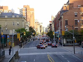
Front Street is an east–west road in downtown Toronto, Ontario, Canada. First laid out in 1796, the street is one of the original streets of the Town of York. The street was laid out along the shoreline of Lake Ontario as it existed during that time. It remains an important street, with many important uses located along it, including the St. Lawrence Market, Meridian Hall, Union Station and the Metro Toronto Convention Centre. The eastern section of Front Street, in the West Don Lands, east of Cherry Street, is being rebuilt as a broad tree-lined boulevard, intended to be the pedestrian-friendly commercial spine of the new neighbourhood.

<span class="mw-page-title-main">Dufferin Street</span> Roadway in Ontario, Canada

Dufferin Street is a major north–south street in Toronto, Vaughan and King, Ontario, Canada. It is a concession road, two concessions (4 km) west of Yonge Street. The street starts at Exhibition Place, continues north to Toronto's northern boundary at Steeles Avenue with some discontinuities and continues into Vaughan, where it becomes York Regional Road 53. The street is named for Frederick Hamilton-Temple-Blackwood, 1st Marquess of Dufferin and Ava, who served as Governor General of Canada from 1872 to 1878. Prior to 1878 the street was labelled as Western City Limits or Sideline Road south off Bloor. In 2003 and 2007, it was voted as one of "Ontario's Worst 20 Roads" in the Ontario's Worst Roads poll organized by the Canadian Automobile Association.

<span class="mw-page-title-main">Queens Quay (Toronto)</span> Street in the Harbourfront neighbourhood of Toronto, Canada

Queens Quay is a prominent street in the Harbourfront neighbourhood of Toronto, Ontario, Canada. The street was originally commercial in nature due to the many working piers along the waterfront; parts of it have been extensively rebuilt in since the 1970s with parks, condominiums, retail, as well as institutional and cultural development.

<span class="mw-page-title-main">Downtown Toronto</span> Central business district in Toronto, Ontario, Canada

Downtown Toronto is the main central business district of Toronto, Ontario, Canada. Located entirely within the district of Old Toronto, it is approximately 16.6 square kilometres in area, bounded by Bloor Street to the northeast and Dupont Street to the northwest, Lake Ontario to the south, the Don Valley to the east, and Bathurst Street to the west. It is also the home of the municipal government of Toronto and the Government of Ontario.

<span class="mw-page-title-main">Rogers Building (Toronto)</span> Corporate campus of Canadian media conglomerate Rogers Communications

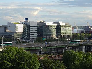
The Rogers Building, located in Toronto, Ontario, Canada, is part of the corporate campus of Canadian media conglomerate Rogers Communications, as well as the home of most, but not all, of the company's Toronto operations.

<span class="mw-page-title-main">Palmerston-Little Italy</span> Neighbourhood in Toronto, Ontario, Canada

Palmerston-Little Italy is a neighbourhood in central Toronto, Ontario, Canada. Its boundaries, according to the City of Toronto, are by Bathurst Street to the east, Bloor Street to the north, Dovercourt Road to the west and College Street to the south. It is a mature downtown neighbourhood. Within this official neighbourhood of the City of Toronto are two neighbourhoods, Palmerston and Little Italy and the commercial enclave of Mirvish Village.

<span class="mw-page-title-main">Lansdowne Avenue</span> Thoroughfare in Toronto, Ontario

Lansdowne Avenue is an arterial road in Toronto, Ontario. It runs north–south and starts at Queen Street West and proceeds north to St. Clair Avenue West. Lansdowne Avenue is primarily a four-lane arterial road, with two lanes regularly used for motor vehicle parking.

<span class="mw-page-title-main">East Bayfront</span> Neighbourhood in Toronto, Ontario, Canada

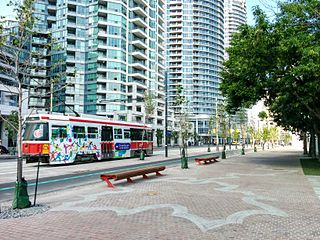
East Bayfront, or the East Bayfront Precinct, is an emerging neighbourhood in Toronto, Ontario, Canada. It is currently undergoing a transformation from industrial use to mixed-use as part of Waterfront Toronto's plans to create a residential and commercial district urban core near the lake.

<span class="mw-page-title-main">Mount Pleasant Road</span> Arterial thoroughfare in Toronto, Canada

Mount Pleasant Road is a major arterial thoroughfare in Toronto, Ontario, Canada. The street extends from Jarvis Street south of Bloor Street north to Glen Echo Drive. The road is unique as one of the few arterial roads in Toronto to be created after the development of the suburbs which it passes through. These include the wealthy Rosedale, Moore Park and Lawrence Park neighbourhoods. The road also passes through the centre of Mount Pleasant Cemetery, after which it takes its name.

Markham Street is a north–south residential street located in the city of Toronto, Ontario, Canada, one block west of Bathurst Street. Its northern end starts in the Seaton Village neighbourhood and it passes through Mirvish Village, Palmerston–Little Italy, Trinity–Bellwoods and ends at West Queen Street West at its south end.

<span class="mw-page-title-main">The Esplanade (Toronto)</span> East-west street in Toronto, Canada

The Esplanade is an east-west street along the central waterfront of Toronto, Ontario, Canada. Originally conceived as a city beautification project to clean up the city's waterfront in the 1850s, the street was taken over by the coming of the railways to Toronto in 1850. The railway eventually moved to an elevated viaduct, leaving only the eastern section of the street today. The area, east of Yonge Street, was dominated by industrial uses until the second half of the 20th century. As the harbour declined as a transfer point, the railway and industrial uses left the area. The Esplanade was redeveloped into a residential area, known as the "St. Lawrence Neighbourhood" in the late 1970s and early 1980s. This neighbourhood consists of generally low-rise and mid-rise housing - condominiums, public housing, cooperatives and some town homes between Jarvis and Parliament Streets south of Front Street. In the blocks between Jarvis and Parliament, the southern part of the street were converted to a long strip of park and recreation space for the residents - David Crombie Park. The stretch between Scott Street and Market Street is a popular restaurant area.

References

  1. "Google Maps". Google Maps. Retrieved 2018-12-03.
  2. "Google Maps". Google Maps. Retrieved 2019-04-12.
  3. "Part Of Jarvis Renamed Ted Rogers Way". toronto.citynews.ca. Retrieved 2019-04-12.
  4. 354 Jarvis Street, Architectural Conservancy Ontario.
  5. 1 2 "Canada's National Ballet School – Facilities". www.nbs-enb.ca. Archived from the original on 2022-02-04. Retrieved 2017-01-23.
  6. "372 Jarvis Street". Archived from the original on 2020-05-10. Retrieved 2020-04-15.
  7. see Goad's Atlas of 1884
  8. "Section of Jarvis St. renamed to honour Ted Rogers". Toronto Star , October 26, 2009.
  9. "Was Jarvis Street named after a city-builder, or a slave-owner? Prepare for a debate" CBC, 7 May 2016
  10. Moloney, Paul; Vincent, Donovan (2009-05-25). "Council approves Jarvis bike lanes". Toronto Star . Retrieved 2009-07-08.
  11. "City hall moves to tear up Jarvis Street bike lanes". The Globe and Mail , June 23, 2011.
  12. "Jarvis reversible fifth lane returns to action". Toronto Sun , November 17, 2012.

Commons-logo.svg Media related to Jarvis Street, Toronto at Wikimedia Commons

Coordinates: 43°39′37.5″N79°22′33″W / 43.660417°N 79.37583°W / 43.660417; -79.37583