Ossington Ave at Dundas St West in 2022Old house at Ossington Avenue
Ossington Avenue is a main or arterial street in Toronto, Ontario, Canada, west of downtown. While the northern 3 kilometres (1.9mi) of Ossington Avenue is residential, its southern terminus is popularly known as the Ossington Strip, an area popular for its dining, nightlife and shopping establishments.
Ossington Avenue is named after the ancestral Nottingham home of the Denison family (see Ossington), early land-owners around the street's southern terminus. (A number of area streets bear Denison-associated names: George Taylor Denison's 'Brookfield House' stood at the northwest corner of Ossington and Queen Street from around 1815 to 1876, giving its name to Brookfield Street;[1] Dover Court was the residence of nephew Richard Lippincott, initially accessed by Dover Court Road (roughly following the course of contemporary Dovercourt Road);[2] the Fennings and Taylor branches of the family have namesakes as Fennings and Rolyat Streets; Heydon Park and Rusholme were Denison manor houses, giving their names to other local streets.[3])
The origin of Ossington Avenue[4] lies in John Graves Simcoe's 1793 plan for a western military road from York, the new capital of Upper Canada. The initial conception of this road ran west down contemporary Queen Street West (then Lot Street), hugging the shore of Lake Ontario onward to Niagara. This road was to be named Dundas Street, in honor of Simcoe's friend Henry Dundas.
Following the War of 1812, this route was deemed too vulnerable to American invasion, and was destroyed. A more northerly route was substituted, and cut by the Queen's Rangers under the direction of Captain George Taylor Denison, completed by 1817. This route involved an unusual dogleg. Its first segment continued west along Queen Street West, crossing Garrison Creek, and running to the eastern edge of Park Lot 25 (purchased not long before by Denison himself); a short 560-metre (1,840ft) segment then turned north, running between Denison's Park Lot 25 and the neighbouring Park Lot 24 of James Givins; upon meeting an ancient First Nations "desire path" trail following the high ground beneath the western fork of Garrison Creek, the route turned again west along this natural contour, forming the final segment of Dundas Street (and by far the longest, running approximately 70 kilometres (43mi) west to the town of Dundas, Ontario, along the route of contemporary Dundas Street West).
The 560-metre (1,840ft) north–south segment of Dundas Street would become the contemporary "Ossington Strip", and was developed as a mixed commercial and residential street beginning in the 1840s.[5] The Ontario Provincial Lunatic Asylum was opened at the foot of Dundas and Queen Street in 1850.[6] From the 1850s to around 1900, the area was a center of Toronto's meatpacking industry, with slaughterhouses and stockyards on the blocks and laneways just to the east.[7]
Nomenclature would be confusing until a late 1910s reform. By 1884, a street named "Ossington Avenue" had been constructed, running north from Dundas to Bloor Street,[8] and by 1890, as far as St. Clair[9] (though the section north of Davenport was eventually renamed to Winona Drive, and contemporary Ossington Avenue ends at Davenport). As of 1884, "Dundas Street" is a T-shaped entity comprising the Ossington Strip and contemporary Dundas Street West, west of the Garrison Creek bridge at contemporary Crawford Street. By 1894, the eastern spur of Dundas Street had been renamed, with "Arthur Street" consistently applied to contemporary Dundas Street West eastward from the Ossington Strip.[10] Finally, by 1923, contemporary naming is in place, with the Ossington Strip having been renamed "Ossington Avenue" (continuously with the segment running northward from contemporary Dundas and Ossington) and Arthur Street having been renamed "Dundas Street" (continuously with the segment running eastward from contemporary Dundas and Ossington).[11]
In 1968, after assassinating Martin Luther King Jr., James Earl Ray fled to Toronto and lived in a rooming house on Ossington Avenue. Ray would visit "a bar around the corner from Ossington St.", probably the Drake Hotel, where he would watch the news on the bar's television.[12]
As Toronto expanded west and other retail facilities opened, the Ossington Strip became an area of industrial uses, including automotive repairs and storage facilities. By 2003, this area became known for crime and the known presence of Vietnamese criminal gangs and street drug peddlers. A double murder in a karaoke bar that year sparked neighbourhood action in concert with the police to cut down on crime.[13]
By 2007, the low rents of stores along Ossington became attractive after rents along Queen Street West increased. This led to an influx of bars, restaurants, and stores. By 2009, the number of bars and restaurants created tension with residents of the surrounding neighbourhood, and licensing controls were imposed to stop the opening of more businesses of the same kind.[14] In 2010, the restrictions on new restaurants along Ossington were lifted, leading to the opening of several new establishments.[15]
Character
At its south end, Ossington starts at Queen Street and goes north, up a hill to Dundas Street. South of Queen is the Centre for Addiction and Mental Health's (CAMH) Queen Street Health Centre complex. From Shaw Street west to Dovercourt, the south side of Queen street is used for CAMH facilities. In summer 2012, Ossington was extended southward onto the CAMH campus and called Lower Ossington Avenue.
From this intersection north to Dundas, Ossington is largely lined with low-rise retail storefronts, typically with apartments on upper floors; other buildings house light industrial uses. Most buildings along this stretch date to the 19th century, and many have been restored in their conversion into restaurants and trendy stores, which have attracted visitors from around the Greater Toronto Area and made the area a magnet for international tourists visiting Toronto.
North of Dundas, the street changes to a primarily residential street. The road slopes down here as it goes into the Garrison Creek ravine, (the creek is buried nowadays) then starts a gradual slope up to its terminus at Davenport. The homes are typically two-story detached or semi-detached homes. This stretch has streetcar tracks and is used by the TTC often for short-turns by the 505 Dundas and 506 College streetcar routes.
North of College, on the west side is Dewson Street public school. One block east on Shaw Street is Central Commerce Collegiate high school. The next street to connect is Harbord Street which goes east from Ossington to Queen's Park Circle. The area is residential on both sides of the street.
North of Bloor Street, the street rises gently until just before Davenport where it reaches the old shoreline and the street rises rapidly to meet Davenport. Except for some businesses around the railway bridge north of Dupont, both sides of the street are two-storey residences.
Yonge Street is a major arterial route in the Canadian province of Ontario connecting the shores of Lake Ontario in Toronto to Lake Simcoe, a gateway to the Upper Great Lakes.
Bay Street is a major thoroughfare in Downtown Toronto, Ontario, Canada. It is the centre of Toronto's Financial District and is often used by metonymy to refer to Canada's financial services industry since succeeding Montreal's St. James Street in that role in the 1970s.
Trinity—Spadina was a federal electoral district in Ontario, Canada, that was represented in the House of Commons of Canada from 1988 to 2015.
Spadina Avenue is one of the most prominent streets in Toronto, Ontario, Canada. Running through the western section of downtown, the road has a very different character in different neighbourhoods.
Toronto—St. Paul's is a federal electoral district in Toronto, Ontario, Canada, that has been represented in the House of Commons of Canada since 1935. Its current MP is Carolyn Bennett. Prior to the 2015 election, the riding was known as St. Paul's.
Garrison Creek was a short stream about 7.7 kilometres (4.8 mi) long that flowed southeast into the west side of Toronto Harbour in Ontario, Canada. It has been largely covered over and filled in, but geographical traces of the creek can still be found, including the natural amphitheatre known as Christie Pits and the off-leash dog "bowl" of Trinity Bellwoods Park. The name "Garrison Creek" was used because Fort York was built near the creek mouth. Volunteers lead popular tours of the course of the old watershed.
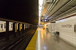
Ossington is a subway station on Line 2 Bloor–Danforth of the Toronto subway in Toronto, Ontario, Canada. It is located at Ossington Avenue just north of Bloor Street West and opened in 1966 as part of the original segment of the subway line. Wi-Fi service is available at this station.
Dovercourt Park or Dovercourt Village is a neighbourhood in Toronto, Ontario, Canada situated north of Bloor Street between Christie Street to the east, the CPR railway lines to the north, and Dufferin Street to the west.
The Toronto Street Railway (TSR) was the operator of a horse-drawn streetcar system from 1861 to 1891 in Toronto, Ontario, Canada. Its successor, the Toronto Railway Company, inherited the horsecar system and electrified it between 1892 and 1894.
College Street is a principal arterial thoroughfare in downtown Toronto, Canada, connecting former streetcar suburbs in the west with the city centre. The street is home to an ethnically diverse population in the western residential reaches, and institutions like the Ontario Legislature and the University of Toronto in the downtown core. At Yonge Street, College continues to the east as Carlton Street.
The Relief Line was a proposed rapid transit line for the Toronto subway system, intended to provide capacity relief to the Yonge segment of Line 1 and Bloor–Yonge station and extend subway service coverage in the city's east end. Several plans for an east–west downtown subway line date back to the early 20th century, most of which ran along Queen Street.
The 505 Dundas is a Toronto streetcar route run by the Toronto Transit Commission in Ontario, Canada. The route is roughly U-shaped running mainly along Dundas Street between Dundas West and Broadview stations several blocks south of the Line 2 Bloor–Danforth subway.
Islington-City Centre West is a commercial and residential neighbourhood in Toronto, Ontario, Canada. One of four central business districts outside Downtown Toronto, it is bounded by Rathburn Road to the north, Islington Avenue to the east, Bloor Street to the south, Mimico Creek to the west.
Lansdowne Avenue is an arterial road in Toronto, Ontario. It runs north–south and starts at Queen Street West and proceeds north to St. Clair Avenue West. Lansdowne Avenue is primarily a four-lane arterial road, with two lanes regularly used for motor vehicle parking.
Trinity-Bellwoods is an inner city neighbourhood in Toronto, Ontario, Canada. It is bounded on the east by Bathurst Street, on the north by College Street, on the south by Queen Street West, and by Dovercourt Road on the west. It has a large Portuguese and Brazilian community, and many local Portuguese-Canadian businesses are located along Dundas Street West, continuing west into Little Portugal; this stretch further west along Dundas is known as Rua Açores.
Parkdale was a provincial riding electing Members of Provincial Parliament (MPP) to the Legislative Assembly of Ontario. The riding was created from the western part of Toronto West riding in 1914 and abolished in 1996 and redistributed into the Parkdale—High Park, Davenport and Trinity—Spadina ridings for the 1999 Ontario general election.
The Harbord streetcar line was an east-west line within the Toronto streetcar system. The route was named after Harbord Street even though only a small portion of the route was along the namesake street. One distinct characteristic of the route was its zip-zag nature, making many 90-degree turns onto the various streets along its route. The route was retired in 1966 when the Toronto Transit Commission (TTC) opened the Bloor–Danforth subway line, the city's first east-west subway line.
Dundas Street is a major historic arterial road in Ontario, Canada. The road connects the city of Toronto with its western suburbs and several cities in southwestern Ontario. Three provincial highways—2, 5, and 99—followed long sections of its course, although these highway segments have since been downloaded to the municipalities they passed through. Originally intended as a military route to connect the shipping port of York to the envisioned future capital of London, Ontario, the street today connects Toronto landmarks such as Yonge–Dundas Square and the city's principal Chinatown to rural villages and the regional centres of Hamilton and London.
This page is based on this Wikipedia article Text is available under the CC BY-SA 4.0 license; additional terms may apply. Images, videos and audio are available under their respective licenses.


