Victoria Park Avenue

Last updated
Victoria Park Avenue
Victoria Park Avenue Sign Markham.jpg
Victoria Park Avenue Toronto.jpg
Victoria Park Ave map.png
Victoria Park Avenue within Toronto
Maintained by City of Toronto government, York Region
Location Toronto
Markham
South end Queen Street East
(In the City of Toronto)
Major
junctions
North endDenison St
(In the City of Markham)
Nearby arterial roads in Toronto

Victoria Park Avenue is a major north-south route in eastern Toronto, Ontario, Canada. It is the western border of Scarborough, separating it from Old Toronto, East York, and North York. The common nickname for it is VP or Vic Park.

Contents

History

Victoria Park is a narrow residential street as it climbs the western edge of the Scarborough Bluffs in the Beaches Vic Park at Queen.JPG
Victoria Park is a narrow residential street as it climbs the western edge of the Scarborough Bluffs in the Beaches
Victoria Park Avenue at Victoria Village Victoria Park Ave Aerial view to north in Victoria Village 2023.jpg
Victoria Park Avenue at Victoria Village

Victoria Park Avenue was originally a pioneer road for settlement of Scarborough. Except for its very southernmost section (south of Bracken Avenue), the road once formed the boundary for the former township, borough, and city of Scarborough with the former municipalities of East York, North York, and the former city of Toronto. Road was also called. Scarborough-York Town Line.

The road took its name from the Victoria Park amusement park that operated south of Queen Street from 1878 until 1906. [1]

Route description

Victoria Park Avenue begins as a two-lane residential street near Lake Ontario at Queen Street at the east end of The Beaches community. It takes a sharp jog west just before Bracken Avenue, and then continues in a straight line northward.

It remains a two-lane residential street past Bracken Avenue north to Gerrard Street, albeit one with a heavy traffic load; at Gerrard Street it becomes a four-lane major arterial road. It reduces to two lanes again from a point north of Danforth Avenue to Dawes Road, then returns to four lanes for rest of its length. [2] North of Dawes it shifts from being a residential street to being a suburban arterial, with mostly stores and low rise apartment buildings along the rest of its length. North of McNicoll Avenue the route is a mixed commercial and light industrial street.
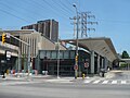
Victoria Park Avenue ends a short distance north of Steeles Avenue at Denison Street in Markham, Ontario.

Public transit

Victoria Park remains one of the busiest north-south streets in Scarborough, along with Markham Road and Kennedy Road. It is served by the Toronto subway at Victoria Park station.

Historically the first bus to service the street were private routes that operated along Dawes Road, and then north along Victoria Park. This route was taken over by the TTC in 1954, and offered service as far north as Victoria Park and Lawrence. [3] The opening of Victoria Park subway station in 1968 led to the creation of the 24 Victoria Park, replacing the Dawes Road bus on Victoria Park. It first ran to Victoria Park and Old Sheppard Avenue, but has steadily been extended northwards. With the opening of Sheppard subway in 2002, the 224 Victoria Park North ran from Don Mills station into Markham. The 224 went back to the older alignment with the 24D Victoria Park branch in 2016, then was replaced by the 24 Woodbine bus operated by York Region Transit later in 2016.

Also beginning in 1968, the portion of Victoria Park south of Victoria Park station began to be served by the 12 Kingston Road bus. This bus travels south of the station until Kingston Road and then turns east along Kingston to travel into Scarborough. It stops at Bingham Loop to meet up with the termini of the 503 Kingston Rd. [4]

Landmarks

LandmarkCross streetNotesImage
R. C. Harris Water Treatment Plant Queen StFormer site of Victoria Park amusement park Palace of purification.jpg
Neil McNeil Catholic Secondary School Bracken Ave Neil McNeil High School.JPG
Shoppers World Danforth Danforth AveFormer auto plant Shoppers World Danforth.JPG
Victoria Park subway station Denton Ave Victoria Park TTC west end.JPG
Dentonia ParkDenton AveAlso has a golf course which along with Crescent Town were once part of Walter Massey’s Dentonia Park dairy farm that supplied milk to his City Dairy Company Limited. Dentonia Park.jpg
Eglinton Square Shopping Centre Eglinton Ave Eglinton Square.jpg
Church of St. Jude (Wexford) Sloane Ave St Jude, Toronto.JPG
Senator O'Connor College School Rowena Dr Senator O'Connor College School.JPG
Victoria Park Collegiate Institute Cassandra Blvd VictoriaParkCollegiateInstitute - 20150607.JPG
Annunciation of the Blessed Virgin Mary Roman Catholic ChurchCombermere Dr Annunciation of the Blessed Virgin Mary, Toronto.JPG
Parkway Mall Ellesmere Rd Parkway Mall - Metro.JPG
St. Andrew Anglican ChurchTerraview Blvd St Andrew Anglican Church, Scarborough.JPG
Johnny's Charcoal Broiled Hamburgers Sheppard Ave Johnny's Hamburgers in December 2015.jpg

See also

Related Research Articles

<span class="mw-page-title-main">The Beaches, Toronto</span> Neighbourhood in Toronto, Ontario, Canada

The Beaches is a neighbourhood in Toronto, Ontario, Canada. It is so named because of its four beaches situated on Lake Ontario. It is located east of downtown within the "Old" City of Toronto. The approximate boundaries of the neighbourhood are from Victoria Park Avenue on the east to Kingston Road on the north, along Dundas Street to Coxwell Avenue on the west, south to Lake Ontario. The Beaches is part of the east-central district of Toronto.

<span class="mw-page-title-main">Finch Avenue</span> Road in Toronto, Ontario, Canada

Finch Avenue is an arterial thoroughfare that travels east–west in Toronto, Ontario, Canada. The road continues west into the Regional Municipality of Peel as Regional Road 2 and east into the Regional Municipality of Durham as Regional Road 37.

<span class="mw-page-title-main">Cancelled expressways in Toronto</span> Unbuilt freeways in Toronto, Canada

The cancelled expressways in Toronto were a planned series of expressways in Toronto, Ontario, Canada that were only partially built or cancelled due to public opposition. The system of expressways was intended to spur or handle growth in the suburbs of Toronto, but were opposed by citizens within the city of Toronto proper, citing the demolition of homes and park lands, air pollution, noise and the high cost of construction. The Spadina Expressway, planned since the 1940s, was cancelled in 1971 after being only partially constructed. After the Spadina cancellation, other expressway plans, intended to create a 'ring' around the central core, were abandoned.

<span class="mw-page-title-main">Lawrence Avenue</span> Thoroughfare in Toronto, Ontario

Lawrence Avenue is a major east–west thoroughfare in Toronto, Ontario, Canada. It is divided into east and west portions by Yonge Street, the dividing line of east–west streets in Toronto.

<span class="mw-page-title-main">Eglinton Avenue</span> Road in Toronto and Mississauga, Canada

Eglinton Avenue is a major east–west arterial thoroughfare in Toronto and Mississauga in the Canadian province of Ontario. The street begins at Highway 407 at the western limits of Mississauga, as a continuation of Lower Baseline in Milton. It traverses the midsection of both cities and ends at Kingston Road. Eglinton Avenue is the only street to cross all six former cities and boroughs of Metropolitan Toronto.

<span class="mw-page-title-main">Morningside Avenue (Toronto)</span> Road in Toronto, Ontario, Canada

Morningside Avenue is a suburban arterial road in Toronto, Ontario, Canada. It is entirely within Scarborough, running north by north-west from the Scarborough Bluffs overlooking Lake Ontario to the eastern terminus of McNicoll Avenue near the Rouge River valley. A short extension from Steeles Avenue to Passmore Avenue has been completed but the connection to the southern section to McNicoll Avenue is still not completed.

<span class="mw-page-title-main">Sheppard Avenue</span> Road in Toronto, Ontario, Canada

Sheppard Avenue is an east–west principal arterial road in Toronto, Ontario, Canada. The street has two distinct branches near its eastern end, with the original route being a collector road leading to Pickering via a turnoff, and the main route following a later-built roadway which runs south to Kingston Road. To avoid name duplication, the Toronto portion of the northern branch was renamed Twyn Rivers Drive. The section of the street entirely in Toronto is (34.2 km) in length, while the Pickering section and Twyn Rivers Dr. is (5.4 km) long.

<span class="mw-page-title-main">Steeles Avenue</span> Road in Ontario, Canada

Steeles Avenue is an east–west street that forms the northern city limit of Toronto and the southern limit of York Region in Ontario, Canada. It stretches 77.3 km (48.0 mi) across the western and central Greater Toronto Area from Appleby Line in Milton in the west to the Toronto-Pickering city limits in the east, where it continues east into Durham Region as Taunton Road, which itself extends 58 km (36 mi) across the length of Durham Region to its boundary with Northumberland County.

<span class="mw-page-title-main">Danforth Avenue</span> Arterial street in Toronto

Danforth Avenue and Danforth Road are two historically-related arterial streets in Toronto, Ontario, Canada. Danforth Avenue is an east-west street that begins in Old Toronto at the Prince Edward Viaduct as a physical continuation of Bloor Street and continues for about 6 kilometres (3.7 mi) east through old Toronto, about 350 metres (1,150 ft) of old East York, and a further 5 kilometres (3.1 mi) in Scarborough until it intersects with Kingston Road via a ramped interchange. Danforth Road splits off the Avenue west of Warden Avenue and runs diagonally northeast until south of Lawrence Avenue, where it continues as McCowan Road.

<span class="mw-page-title-main">Kingston Road (Toronto)</span> Road in Toronto and Durham, Ontario, Canada

Kingston Road is a major arterial road in Toronto and Durham Region, Ontario. It is the southernmost major (mainly) east-west road in the eastern portion of Toronto, specifically in the district of Scarborough, and runs east to Ajax in Durham. Until 1998, it formed a portion of Highway 2. The name of the street is derived from Kingston, Ontario as the road was the primary route used to travel from Toronto to the settlements east of it situated along the shores of Lake Ontario; in the west end of Kingston, the road was referred to as the York Road until at least 1908, and is today named Princess Street.

<span class="mw-page-title-main">McCowan Road</span>

McCowan Road is a major north-south thoroughfare in the Greater Toronto Area, Canada. It runs through the city of Toronto and into the Regional Municipality of York where it ends at the Town of Georgina.

<span class="mw-page-title-main">Brimley Road</span> Thoroughfare in Toronto, Ontario

Brimley Road is a north-south street in Toronto and the Regional Municipality of York, Ontario, Canada. In Toronto, it is located entirely within Scarborough and carried 32000 vehicles daily in May 2007 Hence, it is classified as a major arterial road by the city of Toronto.

Transportation in the Canadian city of Toronto forms the hub of the road, rail and air networks in the Greater Toronto Area and much of southern Ontario. There are many forms of transport in the city, including railways, highways, and public transit. Toronto also has an extensive network of bicycle lanes and multi-use trails and paths.

<span class="mw-page-title-main">Toronto and Scarboro' Electric Railway, Light and Power Company</span> Former railcar company in Toronto

Toronto and Scarboro' Electric Railway, Light and Power Company was established in August 1892 to provide street railway service to the Upper Beaches district within the City of Toronto, Ontario and to the neighbouring Township of Scarborough. Except for two branches, the line ran as a radial along Kingston Road.

The city of Markham in Ontario, Canada, offers a complex transportation infrastructure. These include airports, highways, public transit, regional roads, municipality-funded roads, and train services.

<span class="mw-page-title-main">Woodbine Avenue</span> Road in Ontario, Canada

Woodbine Avenue is a north–south arterial road consisting of two sections in Toronto and York Region in Ontario, Canada.

References

  1. Filey, Mike (2008). Toronto: The Way We Were. Dundurn Press. p. 44. ISBN   9781770703506.
  2. Mutrie, Eric (2010-11-18). "Street Stories: Victoria Park Avenue". Spacing Toronto. Retrieved 2023-07-16.
  3. Peter Coulman "23 Dawes" Transit Toronto.
  4. Peter Coulman "12 Kingston Road" Transit Toronto.