Main Street Unionville

Last updated
Main Street Unionville
Main Street Unionville.PNG
(Main Street)
Main Street Unionville Location.PNG
Main Street Unionville is shown in red
Length2.75 km (1.71 mi)
Location Markham
York
South endEnterprise Drive / Unionville Gate
Major
junctions
York Regional Road 7.svg Highway 7
North endRosemary Close
Construction
Inauguration1840
Unionville's Welcome Sign found near the street's intersection with Fred Varley Drive. Unionville Sign.jpg
Unionville's Welcome Sign found near the street's intersection with Fred Varley Drive.

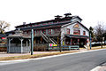
Main Street Unionville is a collector route that runs through the historical suburban community of Unionville, in Markham, Ontario, Canada. Like most other Main Streets, the street serves as an important road for local tourism development. All along the road, the street has structures that are virtually unchanged from its founding in 1794. Renowned for its pubs, parks, restaurants, and its historical European view, the road also hosts the annual Unionville Festival, which draws several thousand visitors to the neighbourhood.

Contents

Road Information

History

Entertainment

Main Street Unionville hosts annual jazz and Celtic festivals, as well as live music in the new bandstand in the summer. The street was also used as a stand-in for fictional Connecticut town Stars Hollow during the first season of The WB's Gilmore Girls television show. Other productions to have used Main Street as a filming location include The Scream Team in 2002, and Secrets of Eden in 2011.

The 1994 John Carpenter film, In the Mouth of Madness prominently features the northernmost part of the street as a stand-in for a fictional New England town, especially the exterior of the Unionville Arms Pub.

Road History

Main Street Unionville was the original 6th line of Markham Township. This road was undeveloped until about 1840 when the mill was developed at what is now Carlton Road. The mill needed the water from the pond to the north-west but the swamp to its immediate south made travel virtually impossible. The common road developed along the ridge to the south, and this became the main passageway. About this time the area on the north-west corner of the road and 15th Avenue (later Highway 7, and now York Regional Road 7) was subdivided but undeveloped until the coming of the railway in 1872. Unionville, as the center of the township, had until the 1970s held the town offices. The development of the subdivision immediately to the west of the small town in the late 1960s, brought attention to the run down nature of the buildings in the business area. The provincial government, with support of the regional and township governments were prepared to widen the road, which would have meant the demolition of the buildings. A great furor arose, culminating the Unionville Annual Festival, whose original purpose was to bring attention to the situation and to raise funds to fight the widening. Quickly, local politicians came on board and the road widening was stopped. In the early 1980s, the bypass was built around Main Street Unionville to relieve the heavy traffic. The bypass became the new alignment for Kennedy Road, though it was named Unionville By-pass for a number of years at first, and the original line was renamed as Main Street Unionville. With the coming of change the buildings were revived and a unique Victorian Village atmosphere came into being.

Settlement History

Landmarks

Major Intersections

The following table lists the major junctions along Main Street Unionville. [1] The entire route is located in Markham, Ontario, within the Regional Municipality of York. 

km [1] miDestinationsNotes
0.00.0 Cul-de-sac south of Enterprise Avenue
0.20.12Enterprise Avenue / Unionville GateMarkham Pan Am Centre located southwest of intersection
0.80.50 York Regional Road 7.svg Highway 7
1.71.1Carlton Road
2.41.5Rosemead CloseExit of Fire Station north of intersection
1.000 mi = 1.609 km; 1.000 km = 0.621 mi

Related Research Articles

<span class="mw-page-title-main">Markham, Ontario</span> City in Ontario, Canada

Markham is a city in the York Region of Ontario, Canada. It is approximately 30 km (19 mi) northeast of Downtown Toronto. In the 2021 Census, Markham had a population of 338,503, which ranked it the largest in York Region, fourth largest in the Greater Toronto Area (GTA), and 16th largest in Canada.

<span class="mw-page-title-main">William Berczy</span> Canadian pioneer and painter (1744–1813)

William von Moll Berczy was a German-born Upper Canada pioneer and painter. He is considered one of the co-founders of the Town of York, Upper Canada, now Toronto, Ontario, Canada.

Stouffville is the primary urban area within the town of Whitchurch-Stouffville in York Region, Ontario, Canada. It is situated within the Greater Toronto Area and the inner ring of the Golden Horseshoe. The urban area is centred at the intersection of Main Street, Mill Street, and Market Street. Between 2006 and 2011, the population of the Community of Stouffville grew 100.5% from 12,411 to 24,886, or from 51% to 66% of the total population of the larger town of Whitchurch-Stouffville. The population of Stouffville from the 2021 census is 36,753.

<span class="mw-page-title-main">Steeles Avenue</span> Road in Ontario, Canada

Steeles Avenue is an east–west street that forms the northern city limit of Toronto and the southern limit of York Region in Ontario, Canada. It stretches 77.3 km (48.0 mi) across the western and central Greater Toronto Area from Appleby Line in Milton in the west to the Toronto-Pickering city limits in the east, where it continues east into Durham Region as Taunton Road, which itself extends 58 km (36 mi) across the length of Durham Region to its boundary with Northumberland County.

<span class="mw-page-title-main">Unionville, Ontario</span> Suburban district in York, Ontario, Canada

Unionville is a suburban district and former village in Markham, Ontario, Canada, 2 km (2.5 mi) west of Markham Village, and 33 km (20.5 mi) northeast of Downtown Toronto. The boundaries of Unionville are not well-defined. Several neighbourhoods claim to be part of it however, this has been disputed between the various wards.

<span class="mw-page-title-main">History of Markham, Ontario</span>

The history of Markham, Ontario dates back several millennia. What would become Markham, Ontario was home to First Nations long before European settlement. Seasonal settlements were found from 900 BC to 1650, but traces of these first residence were buried before the area was farmed.

German Mills is a community within the city of Markham in Ontario, Canada. The easternmost community in the historic town of Thornhill, German Mills was named for the early German settlers in the area.

<span class="mw-page-title-main">Georgia State Route 72</span> State highway in Georgia, United States

State Route 72 (SR 72) is a 46.7-mile-long (75.2 km) state highway that runs west-to-east through portions of Clarke, Madison, and Elbert counties in the northeastern part of the U.S. state of Georgia. This route is part of a multi two-state route 72 that begins at Athens, Georgia and ends at Rock Hill, South Carolina. The route connects the Athens area with the South Carolina state line, southwest of Calhoun Falls, South Carolina, via Comer and Elberton.

<span class="mw-page-title-main">Interstate 70 in Pennsylvania</span> Section of Interstate highway in Pennsylvania, United States

Interstate 70 (I-70) is a state highway that is located in the Commonwealth of Pennsylvania in the United States. It runs east to west across the southwest part of Pennsylvania and serves the southern fringe of the Pittsburgh metropolitan area.

<span class="mw-page-title-main">Pennsylvania Route 51</span> State highway in Pennsylvania

Pennsylvania Route 51 is a major state highway that is located in Western Pennsylvania in the United States. It runs for 89 miles (143 km) from Uniontown to the Ohio state line near Darlington, where it connects with Ohio State Route 14.

<span class="mw-page-title-main">Pennsylvania Route 21</span> State highway in Pennsylvania, US

Pennsylvania Route 21 is a 50.75-mile (81.67 km) long east–west state highway in the US state of Pennsylvania. The western terminus of the route is at the West Virginia state line in Richhill Township, where PA 21 continues into West Virginia as West Virginia Route 891. The eastern terminus is at U.S. Route 40 Business in Uniontown. The route is known as the Roy E. Furman Highway for most of its length. PA 21 serves Waynesburg and Masontown along the way.

Hagerman's Corners is a dispersed rural community in Markham, Ontario, Canada. Located at 14th Avenue and Kennedy Road, the former farm lands have disappeared and given way to homes and commercial parks. It is geographically located between the communities of Milliken Mills and Unionville, within the city of Markham.

John Street is an east-west collector and arterial road in the City of Markham, Ontario, Canada. It is one of the oldest roads in the Markham and forms the east-west backbone of the 200-year-old community of Thornhill.

<span class="mw-page-title-main">Donald Cousens Parkway</span> Arterial bypass of Markham

Donald Cousens Parkway or York Regional Road 48, also referred to historically as the Markham Bypass or Markham Bypass Extension, is a regionally-maintained arterial bypass of Markham in the Canadian province of Ontario. Named for former Markham mayor Don Cousens in April 2007, the route initially travelled northward from Copper Creek Drive in Box Grove, south of Highway 407, to Major Mackenzie Drive. A southern extension to Steeles Avenue was later completed and the name Donald Cousens Parkway applied along the extension to Ninth Line. In addition to its role of funneling through-traffic around downtown Markham, the route serves as a boundary to residential development as land to the north and east are part of the protected Rouge National Urban Park and southwest limits of the planned Pickering Airport.

Cashel, Ontario is a small hamlet situated in Unionville, Ontario located at the intersection of Elgin Mills Road and York Regional Road 67. Originally it was called Crosby Corners after John Crosby, the village's first store owner, who came originally from New York State. The name was changed to Cashel in 1851 with the opening of its first post office. It was likely named after Cashel in Ireland. In 1851 the community had a sawmill, cobbler shop, blacksmith shop, wagon shop, inn and tavern, Masonic Lodge, and Presbyterian church. In 1890 Peaches United Church was built on land from farmer Thomas Peach at 10762 McCowan Road. The church is a historic site and not operating since the 1960s to 1970s, but cemetery remains in active use. The east west sideroad along the church was locally called Peaches (Peach's) Sideroad or otherwise known as Elgin Mills Road.

<span class="mw-page-title-main">Pennsylvania Route 332</span> State highway in Pennsylvania, US

Pennsylvania Route 332 (PA 332) is a state highway in the U.S. state of Pennsylvania. The route runs 17.5 miles (28.2 km) from PA 263 in Hatboro, Montgomery County, east to PA 32 in Yardley, Bucks County. PA 332 runs through suburban areas to the north of Philadelphia, serving Warminster, Ivyland, Richboro, and Newtown. The route is two lanes wide most of its length, with the bypass around Newtown a four-lane divided highway. PA 332 intersects PA 132 in Warminster, PA 232 in Richboro, PA 413 and PA 532 in Newtown, and Interstate 295 (I-295) in Lower Makefield Township.

<span class="mw-page-title-main">Berczy Village</span> Planned neighbourhood in York, Ontario, Canada

Berczy Village is a residential neighbourhood in Markham, Ontario, Canada. It is bounded to the north by Major Mackenzie Drive, to the east by McCowan Road, to the south by 16th Avenue, and to the west by Kennedy Road. This area is north of Unionville. The community is named after William Berczy, Markham's founder. The name can be found on limestone plaques throughout the community's many arterial road entrances.

Downtown Markham is the main central business district of Markham, Ontario, Canada. Currently under development, it is located within Markham Centre near the historic Unionville district and is proposed to serve as the heart of Markham. Businesses in the district are expected to employ up to 16,000 individuals, and it may house as many as 10,000 residents. The development plans will have a high density of residential, retail, commercial and mixed-use structures. The community is being developed, built and wholly financed by The Remington Group Inc.

<span class="mw-page-title-main">Toogood Pond Park</span>

Toogood Pond Park is a 33.3-hectare park located in the neighbourhood of Unionville, in Markham, Ontario, Canada that is best known for Toogood Pond. The pond is home to many Canada geese, ducks, fish, and plants. The park is owned and operated by the Corporation of the City of Markham, and is maintained by the city's Parks Department.

References

  1. 1 2 Google (3 March 2019). "Length and route of existing Main Street Unionville" (Map). Google Maps . Google. Retrieved 3 March 2019.

43°51′57″N79°18′39″W / 43.86585°N 79.31093°W / 43.86585; -79.31093