
Markham is a city in York Region, Ontario, Canada. It is approximately 30 km (19 mi) northeast of Downtown Toronto. In the 2021 Census, Markham had a population of 338,503, which ranked it the largest in York Region, fourth largest in the Greater Toronto Area (GTA), and 16th largest in Canada.

Richmond Hill is a city in south-central York Region, Ontario, Canada. Part of the Greater Toronto Area, it is the York Region's third most populous municipality and the 27th most populous municipality in Canada. Richmond Hill is situated between the cities of Markham and Vaughan, north of Thornhill, and south of Aurora.

Thornhill is a suburban district in the Regional Municipality of York in Ontario, Canada. The western portion of Thornhill is within the City of Vaughan and its eastern portion is within the City of Markham, with Yonge Street forming the boundary between Vaughan and Markham. Thornhill is situated along the northern border of Toronto, centred on Yonge, and is also immediately south of the City of Richmond Hill. Once a police village, Thornhill is still a postal designation. As of 2016, its total population, including both its Vaughan and Markham sections, was 112,719.

The Rouge River is a river in Markham, Pickering, Richmond Hill and Toronto in the Greater Toronto Area of Ontario, Canada. The river flows from the Oak Ridges Moraine to Lake Ontario at the eastern border of Toronto, and is the location of Rouge Park, the only national park in Canada within a municipality. At its southern end, the Rouge River is the boundary between Toronto and southwestern Pickering in the Regional Municipality of Durham.

German Mills Creek is a river in the municipalities of Markham, Richmond Hill, Toronto and Vaughan in the Greater Toronto Area of Ontario, Canada. It is part of the Great Lakes Basin and is a left tributary of the East Branch Don River. It originates in Vaughan, flows south through Richmond Hill and Markham, and empties into the East Branch Don River in the East Don Parklands in Toronto, south of Steeles Avenue between Bayview Avenue and Leslie Street. It is part of a number of streams, swamps and swales located near the Oak Ridges Moraine. The creek's approximate length is 10 kilometres (6 mi).

Unionville is a suburban district and former village in Markham, Ontario, Canada, 2 km (2.5 mi) northeast of Downtown Markham, 2 km (2.5 mi) west of Markham Village, and 33 km (20.5 mi) northeast of Downtown Toronto, centred around the intersection of Highway 7 and Kennedy Road. The boundaries of Unionville are not well-defined. Several nearby neighbourhoods are claimed to be part of it however, this has been disputed between the various wards. The Unionville Ratepayers Association designates Rodick Road as its western boundary.

The York Region District School Board (YRDSB), until 1999, English-language Public District School Board No. 16 is the English-language public school board for the Regional Municipality of York in Ontario, Canada. The York Region District School Board is the province's third-largest school board after Toronto's TDSB and Peel's PDSB, with an enrolment of over 122,000 students. It is in the fastest-growing census division in Ontario and the third-fastest growing in Canada.
Cornell is a neighbourhood in northeast Markham, Ontario and bounded by Highway 407, 16th Avenue, Ninth Line, and the Donald Cousens Parkway. The 2011 population of this area was 9,880. Adding Cornell North's 2,178 it has 12,058 residents.
Box Grove is a unincorporated community and one of the original hamlets of Markham, Ontario.
Cedar Grove is a community in Markham, Ontario on the Little Rouge River. It is centred on 14th Avenue and Reesor Road and within the boundaries of the future national Rouge Park.
Vinegar Hill is an unincorporated community in Markham, Ontario, Canada bounded by Highway 7 to the north, Highway 407 to the south, and streets just west and east of Main Street South, bordered by the Rouge River. The name of the community is believed to be linked to a cider mill on the east side of the river valley or barrel makers that filled them with vinegar to test their straightness when rolling down Markham Road.
John Street is an east-west collector and arterial road in the City of Markham, Ontario, Canada. It is one of the oldest roads in the Markham and forms the east-west backbone of the 200-year-old community of Thornhill.
Mongolia is an historical community in Markham, Ontario centred on 10th Line and Elgin Mills Rd. East, immediately south of the Town of Whitchurch-Stouffville. The hamlet lies completely within the expropriated federal Pickering Airport lands and also within the proposed boundaries of a future national Rouge Park.
Old Bailey Bridge is a Bailey bridge located below 16th Avenue east of Reesor Road within Rouge Park in Markham, Ontario, Canada. The bridge crossed the Little Rouge Creek, a tributary of the Rouge River. A new bridge was built above this bridge to provide two way access for 16th Avenue east of Ressor Road. The old bridge is in situ with ends fenced off to prevent trespassing.

Toogood Pond Park is a 33.3-hectare park located in the neighbourhood of Unionville, in Markham, Ontario, Canada that is best known for Toogood Pond. The pond is home to many Canada geese, ducks, fish, and plants. The park is owned and operated by the Corporation of the City of Markham, and is maintained by the city's Parks Department.

Duffins Creek is a waterway in the eastern end of the Greater Toronto Area in Ontario, Canada. The watershed of the Duffins Creek is part of the Durham Region and the York Region.
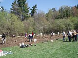 A public treeplanting event in the German Mills Settlers Park
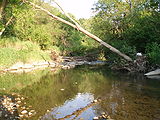 A stream in German Mills Settlers Park
 German Mills Settlers Park
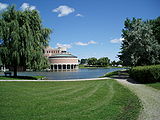 Markham Civic Centre
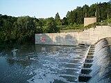 Milne Dam Conservation Park
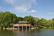 Toogood Pond in Toogood Park
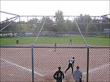 Softball action at Crosby Memorial Park


