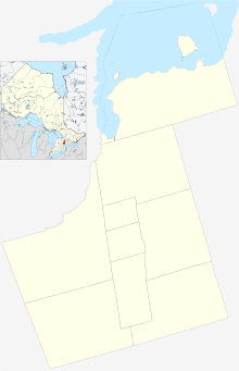
Markham is a city in the York Region of Ontario, Canada. It is approximately 30 km (19 mi) northeast of Downtown Toronto. In the 2021 Census, Markham had a population of 338,503, which ranked it the largest in York Region, fourth largest in the Greater Toronto Area (GTA), and 16th largest in Canada.

The Regional Municipality of York, also called York Region, is a regional municipality in Southern Ontario, Canada, between Lake Simcoe and Toronto. The region was established after the passing of then Bill 102, An Act to Establish The Regional Municipality of York, in 1970. It replaced the former York County in 1971, and is part of the Greater Toronto Area and the inner ring of the Golden Horseshoe. The regional government is headquartered in Newmarket.

York Region Transit (YRT) is the public transit operator in York Region, Ontario, Canada. Its headquarters are in Richmond Hill, at 50 High Tech Road.

Steeles Avenue is an east–west street that forms the northern city limit of Toronto and the southern limit of York Region in Ontario, Canada. It stretches 77.3 km (48.0 mi) across the western and central Greater Toronto Area from Appleby Line in Milton in the west to the Toronto-Pickering city limits in the east, where it continues east into Durham Region as Taunton Road, which itself extends 58 km (36 mi) across the length of Durham Region to its boundary with Northumberland County.

Markham Transit was a public transit system for the town of Markham, Ontario, Canada. It was created in 1973 and operated by Travelways and Miller Transit Limited after 1984 on behalf of the then Town of Markham. The service was merged into York Region Transit in 2001 with Miller Transit continuing to operate most Markham routes.

Markham GO Station is a railway station on the GO Transit Stouffville line network located on Markham Main Street North in Markham, Ontario in Canada.

Mount Joy GO Station is a railway station and bus station in the GO Transit network located in the City of Markham, Ontario, Canada. It is located in the community of Mount Joy, north of the old town of Markham, at the intersection of Markham Road and Bur Oak Avenue and is a stop on the Stouffville line train service. It is also the northern terminus of most of the Stouffville line's off-peak train services.
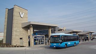
Viva is the bus rapid transit operations of York Region Transit in York Region, Ontario, Canada. Viva service forms the spine for YRT's local bus service, providing seamless transit service across York Region with connections to northern Toronto.
Cornell is a new community village being developed in northeast Markham, Ontario and bounded by Highway 407, 16th Avenue, Ninth Line, and the Donald Cousens Parkway. The 2011 population of this area was 9,880. Adding Cornell North's 2,178 it had 12,058 residents.
Milliken and Milliken Mills are neighbourhoods in the cities of Toronto and Markham. Milliken is situated in the north west section of Scarborough, whereas Milliken Mills is situated in the south-central portions of Markham. The neighbourhoods are centered on Kennedy Road and Steeles Avenue, the latter street serving as the boundary between the cities of Markham and Toronto.

Angus Glen(Census Tract No. 5350403.05) is a community in the city of Markham, just north of the community and former municipality of Unionville, Ontario, Canada. The area was originally farmland, but as Unionville's housing development in the late 1990s matured in 1997 the original Angus Glen East Village, comprising approximately 500 single family homes and townhouses, was developed. Angus Glen incorporated the residential concept of "New Urbanism", to allow for the homes to be designed with the appearance of old downtown Toronto houses, with lane-ways on which the homes' separate garages were built. In the mid-2000s the land west of the small creek on the west border of the East Village commenced development, and is still under construction, known as the West Village. Throughout this period the East Village had a tract of land which had originally been sold to the school board for a possible school. However, the demographic studies could not support a school and after many years of negotiations the developer re-purchased the land in early 2014 and the East Village has had approximately 50 homes under construction, just east of the baseball park and along the north border of York Downs Golf Club. These homes will increase the East Village's homes to close to 600 and the entire community to approximately 1,100.

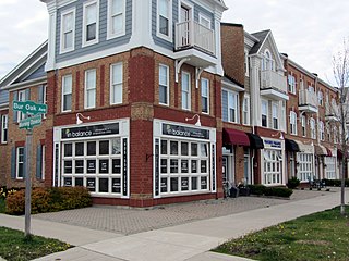
Berczy Village is a residential neighbourhood in Markham, Ontario, Canada. It is bounded to the north by Major Mackenzie Drive, to the east by McCowan Road, to the south by 16th Avenue, and to the west by Kennedy Road. This area is north of Unionville. The community is named after William Berczy, Markham's founder. The name can be found on limestone plaques throughout the community's many arterial road entrances.
The city of Markham in Ontario, Canada, offers a complex transportation infrastructure. These include airports, highways, public transit, regional roads, municipality-funded roads, and train services.

Raymerville - Markville East(Census Tract No. 5350400.03 and 5350400.12) is a community in Markham, Ontario, Canada. The name "Raymerville" came from the community's major collector road, Raymerville Drive. The name "Markville" came from the local major shopping mall, Markville Shopping Centre. The community is referred to as "Markville East" because it is located immediately east of Markville Shopping Centre.

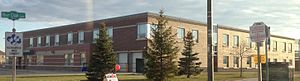
Bur Oak Secondary School (BOSS) is a public secondary school in Markham, Ontario, Canada established in 2007, and is part of the York Region District School Board. The school was named after the road which it is built on, which in turn is named for the city of Markham's official tree, the Bur oak. As of 2018, the school has a student population of approximately 1600.
The City of Vaughan in Ontario, Canada offers a complex transportation infrastructure, which includes highways, public transit, regional roads, municipality-funded roads, and train services.
Woodbine Avenue is a north–south arterial road consisting of two sections in Toronto and York Region in Ontario, Canada.

Cathedraltown is a planned neighbourhood with an estimated population of 3,000 in the City of Markham, just north of Toronto. Cathedraltown was named after the Cathedral of the Transfiguration, around which the neighbourhood was built.
Markham Village is the historic town centre of Markham, Ontario, Canada. Originally settled in 1825, the village, which was originally named "Reesorville" sometime after 1804 and also known as "Mannheim", was founded by Mennonites from Upstate New York and Pennsylvania. Eventually, as Upper Canada started to experience immigration from the British Isles, Markham would experience significant growth. By 1825, the name "Markham" was established as the permanent name. In 1850, it was established as a police village, and in 1873 was fully incorporated as a village within York County. Markham was amalgamated with the surrounding Markham Township, which included the villages of Unionville and Thornhill in 1971, and incorporated as a town.