Cathedraltown

Last updated
Cathedraltown
Neighbourhood
Cathedraltown Markham Streetscape.jpg
The streetscape of Cathedraltown.
Canada Ontario York Region locator map.svg
Red pog.svg
Location within York
Coordinates: 43°53′47″N79°22′28″W / 43.8964°N 79.3744°W / 43.8964; -79.3744
Country Canada
Province Ontario
Regional municipality York
City Markham
Established2006
Population
 (2006 est.)
  Total3,000
Time zone UTC-5 (Eastern Standard Time (EST))
  Summer (DST) UTC-4 (Eastern Daylight Time (EDT))
Area code(s) 905 and 289

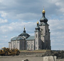
Cathedraltown is a planned neighbourhood with an estimated population of 3,000 [1] in the City of Markham, just north of Toronto. Cathedraltown was named after the Cathedral of the Transfiguration, around which the neighbourhood was built.

Contents

Geography

Cathedraltown is bordered on the north to Major Mackenzie Drive, on the south to Elgin Mills Road, on the west to Victoria Square Boulevard, and on the east to Highway 404.

History

The land occupied by Cathedraltown was originally farmland owned by Romandale Farms, a breeder and exhibitor of Holstein cows. Stephen B. Roman, the late founder of Romandale Farms, built the Cathedral on land he donated. In the early 2000s, his daughter, Helen Roman-Barber, working with Donald Buttress, Surveyor of the Fabric Emeritus of Westminster Abbey, developed the design concept for Cathedraltown, based on European cathedral towns. [2]

The neighbourhood's first residents moved in by 2006 with the completion of homes north of the Cathedral. Since then, single- and multi-family housing and mixed-use condominiums have been built to the west and south of the Cathedral.[ citation needed ]

Architecture and art

Cathedral of the Transfiguration Cathedral of the Transfiguration.jpg
Cathedral of the Transfiguration

Designed under the direction of Donald Buttress, Cathedraltown reflects the Regency and Georgian architecture that was popular in London in the late 18th an early 19th centuries.

In July 2017 a statue of the cow Brookview Tony Charity was erected in Cathedraltown to some controversy. The statue is of a prize-winning cow that was owned jointly by Romandale Farms and Hanover Hill Farms, in the nearby town of Port Perry, where the cow resided. Romandale Farms donated the statue to honour Charity [3] [4] In October 2017, Markham City Council voted to search for a new location for the statue. [5] As of May 2018, the statue has been taken down and placed in storage until a more suitable and accepted home for Charity can be found. [6]

Public transit

The following bus routes serve the neighbourhood:

Related Research Articles

<span class="mw-page-title-main">Markham, Ontario</span> City in Ontario, Canada

Markham is a city in the York Region of Ontario, Canada. It is approximately 30 km (19 mi) northeast of Downtown Toronto. In the 2021 Census, Markham had a population of 338,503, which ranked it the largest in York Region, fourth largest in the Greater Toronto Area (GTA), and 16th largest in Canada.

<span class="mw-page-title-main">Richmond Hill, Ontario</span> City in Ontario, Canada

Richmond Hill is a city in south-central York Region, Ontario, Canada. Part of the Greater Toronto Area, it is the York Region's third most populous municipality and the 27th most populous municipality in Canada. Richmond Hill is situated between the cities of Markham and Vaughan, north of Thornhill, and south of Aurora.

<span class="mw-page-title-main">Regional Municipality of York</span> Regional municipality in Ontario, Canada

The Regional Municipality of York, also called York Region, is a regional municipality in Southern Ontario, Canada, between Lake Simcoe and Toronto. The region was established after the passing of then Bill 102, An Act to Establish The Regional Municipality of York, in 1970. It replaced the former York County in 1971, and is part of the Greater Toronto Area and the inner ring of the Golden Horseshoe. The regional government is headquartered in Newmarket.

<span class="mw-page-title-main">William Berczy</span> Canadian pioneer and painter (1744–1813)

William von Moll Berczy was a German-born Upper Canada pioneer and painter. He is considered one of the co-founders of the Town of York, Upper Canada, now Toronto, Ontario, Canada.

<span class="mw-page-title-main">York Region Transit</span> Public transit operator in York Region, Canada

York Region Transit (YRT) is the public transit operator in York Region, Ontario, Canada. Its headquarters are in Richmond Hill, at 50 High Tech Road.

<span class="mw-page-title-main">Markham Stouffville Hospital</span> Hospital in Ontario, Canada

Markham Stouffville Hospital is an acute care community hospital with two sites: the Markham site, with diagnostic and emergency services, and clinical programs in childbirth, children's health, surgery, medicine, cancer care and mental health; and the Uxbridge site, a 20-bed hospital offering some inpatient and emergency services. In the 2019-2020 fiscal year there were almost 20,000 inpatient stays with an average length of stay of 4.6 days, and 106,000 emergency department visits.

<span class="mw-page-title-main">Bayview Avenue</span> Major north-south route in the Greater Toronto Area of Ontario

Bayview Avenue is a major north–south route in the Greater Toronto Area of Ontario. North of Toronto, in York Region, Bayview is designated as York Regional Road 34.

<span class="mw-page-title-main">Viva Rapid Transit</span> Express bus network in York Region, Ontario

Viva is the bus rapid transit operations of York Region Transit in York Region, Ontario, Canada. Viva service forms the spine for YRT's local bus service, providing seamless transit service across York Region with connections to northern Toronto.

<span class="mw-page-title-main">Cornell, Markham</span> Unincorporated community in Ontario, Canada

Cornell is a new community village being developed in northeast Markham, Ontario and bounded by Highway 407, 16th Avenue, Ninth Line, and the Donald Cousens Parkway. The 2011 population of this area was 9,880. Adding Cornell North's 2,178 it had 12,058 residents.

<span class="mw-page-title-main">Milliken, Ontario</span> Neighbourhood in Ontario, Canada

Milliken and Milliken Mills are neighbourhoods in the cities of Toronto and Markham. Milliken is situated in the north west section of Scarborough, whereas Milliken Mills is situated in the south-central portions of Markham. The neighbourhoods are centered on Kennedy Road and Steeles Avenue, the latter street serving as the boundary between the cities of Markham and Toronto.

<span class="mw-page-title-main">Angus Glen</span> Settlement in Ontario, Canada

Angus Glen(Census Tract No. 5350403.05) is a community in the city of Markham, just north of the community and former municipality of Unionville, Ontario, Canada. The area was originally farmland, but as Unionville's housing development in the late 1990s matured in 1997 the original Angus Glen East Village, comprising approximately 500 single family homes and townhouses, was developed. Angus Glen incorporated the residential concept of "New Urbanism", to allow for the homes to be designed with the appearance of old downtown Toronto houses, with lane-ways on which the homes' separate garages were built. In the mid-2000s the land west of the small creek on the west border of the East Village commenced development, and is still under construction, known as the West Village. Throughout this period the East Village had a tract of land which had originally been sold to the school board for a possible school. However, the demographic studies could not support a school and after many years of negotiations the developer re-purchased the land in early 2014 and the East Village has had approximately 50 homes under construction, just east of the baseball park and along the north border of York Downs Golf Club. These homes will increase the East Village's homes to close to 600 and the entire community to approximately 1,100.

<span class="mw-page-title-main">Victoria Square, Ontario</span> Unincorporated community in Ontario, Canada

Victoria Square is an unincorporated community in Markham, Ontario, Canada. The community was formed in the early nineteenth century.

<span class="mw-page-title-main">Berczy Village</span> Planned neighbourhood in York, Ontario, Canada

Berczy Village is a residential neighbourhood in Markham, Ontario, Canada. It is bounded to the north by Major Mackenzie Drive, to the east by McCowan Road, to the south by 16th Avenue, and to the west by Kennedy Road. This area is north of Unionville. The community is named after William Berczy, Markham's founder. The name can be found on limestone plaques throughout the community's many arterial road entrances.

The city of Markham in Ontario, Canada, offers a complex transportation infrastructure. These include airports, highways, public transit, regional roads, municipality-funded roads, and train services.

<span class="mw-page-title-main">Cathedral of the Transfiguration (Markham, Ontario)</span> Church in Ontario, Canada

The Cathedral of the Transfiguration is a Catholic former cathedral and current parish of the Transfiguration of Jesus Christ, first of the Slovak Greek Catholic Church and currently of the Melkite Greek Catholic Church. The cathedral, in Markham, Ontario, just north of Toronto, is the centrepiece and namesake of Cathedraltown near Victoria Square, an unincorporated hamlet.

Greensborough(Census Tract Number 5350403.03) is a community in the city of Markham in the Regional Municipality of York in the Canadian province of Ontario.

<span class="mw-page-title-main">Woodbine Avenue</span> Road in Ontario, Canada

Woodbine Avenue is a north–south arterial road consisting of two sections in Toronto and York Region in Ontario, Canada.

Markham Village is the historic town centre of Markham, Ontario, Canada. Originally settled in 1825, the village, which was originally named "Reesorville" sometime after 1804 and also known as "Mannheim", was founded by Mennonites from Upstate New York and Pennsylvania. Eventually, as Upper Canada started to experience immigration from the British Isles, Markham would experience significant growth. By 1825, the name "Markham" was established as the permanent name. In 1850, it was established as a police village, and in 1873 was fully incorporated as a village within York County. Markham was amalgamated with the surrounding Markham Township, which included the villages of Unionville and Thornhill in 1971, and incorporated as a town.

<span class="mw-page-title-main">Viva Green</span> Former Viva bus rapid transit line

Viva Green was a Viva bus rapid transit line in York Region, north of Toronto, Ontario, Canada. It was operated by Tok Transit under contract from the Region of York.

Brookview Tony Charity was a notable show cow who at the height of her career was "considered by many to be the best cow ever to walk the face of the earth.". Today she is still cited as the greatest North American show cow of all time.

References

  1. The population can only be estimated as the census tract is shared with other communities, and communities such as Cachet and Greensborough. Together, this census tract makes up a population of 5,414.
  2. "Cathedraltown...suburbia with a twist". UrbanToronto.ca.
  3. Wheeler, Scott (27 July 2017). "Cathedraltown cow just one of family developer's personal design cues". Toronto Star.
  4. "Will controversial cow sculpture be moooved?". www.msn.com.
  5. Javed, Noor (17 October 2017). "Markham cow statue to stay put, for now". The Toronto Star.
  6. Anderson, Kalli (Jun 26, 2018). "Was a freak spring windstorm behind Charity the chrome cow's demise?". cbc.ca. Retrieved 2019-04-11.