Brimley Road

Last updated

Brimley Road

Brimley Rd map.png
Brimley Road in Toronto
Route information
Maintained by City of Toronto
City of Markham
Length16.1 km (10.0 mi)
Major junctions
North end 14th Avenue
Major intersections
South end Scarborough Bluffs
Location
Country Canada
Province Ontario
Highway system
  • Roads in Toronto
Nearby arterial roads
  Midland Avenue
Brimley Road
McCowan Road  

Brimley Road is a north-south street in Toronto and the Regional Municipality of York, Ontario, Canada. In Toronto, it is located entirely within Scarborough and carried 32000 vehicles daily in May 2007 [1] Hence, it is classified as a major arterial road by the city of Toronto. [2]

Contents

Beginning at Scarborough Bluffs by Lake Ontario, [3] Brimley goes straight through Scarborough, past Steeles Avenue and ends at 14th Avenue in Markham. The Scarborough portion is mainly residential with small strip plazas along the way, and the super-regional mall, Scarborough Town Centre. North of Finch Avenue is Brimley Woods (Macklin's Bush), a small forest patch and now city park of what the area once looked like. Past Steeles, Brimley weaves through the residential areas of the Milliken community of Markham.

History

The origins of the street's name is unknown, but it could be named for a village in Teignbridge in England given the origins of many of Scarborough's early settlers. Before the name came into use it was sixth concession east of Yonge Street.

The corner of Brimley Road and Sheppard Avenue marks the central location around which the community of Agincourt was formed during the mid-19th century. [4] The road has also come to border the neighbourhood Kennedy Park [5] and the electoral districts Scarborough—Agincourt [6] and Scarborough—Rouge River. [7]

A museum off Brimley north of Lawrence Avenue East in Thomson Park pays tribute to the founding family of the former Township of Scarborough; West Highland Creek, a tributary of the Highland Creek, runs through the park.

401 overpass

The section south of Sheppard was once interrupted at Highway 401. The construction of the highway lead to the break since the late 1940s and fully by 1956. An $11 million overpass and partial interchange of the freeway was built and opened on October 18, 1987 over the objections of many area residents on concerns over increased traffic volume. In an attempt to address these concerns, it was initially restricted to transit buses and emergency vehicles. [8] After a few months of widely reported public pressure, Scarborough City Council voted February 18, 1988 to open the overpass to general traffic. [9]

A partial interchange is provided between Brimley Road and Highway 401, with westbound access to Highway 401 from northbound Brimley Road, and southbound access to Brimley Road from eastbound Highway 401. Eastbound traffic may also access northbound Brimley Road via the Progress Avenue exit.

Public transit

The main Toronto Transit Commission bus route on Brimley Road is the 21 Brimley, which runs from Steeles Avenue to Eglinton Avenue, stopping on the way through the Scarborough Centre RT station. At Eglinton, it turns west to the Kennedy subway station. The old route of 128 Brimley North, which originally ran from Scarborough Centre to Steeles through McCowan Road and Sheppard Avenue, had started when the RT opened in 1985 and merged with the 21 in 1999. Prior to 1985, TTC service on Brimley north of Sheppard was served by a branch of the 57 Midland route:

The 57A route would continue until it was replaced by 128 Brimley North route.

The 903 Kennedy–Scarborough Centre Express runs on Brimley between Scarborough Centre and Eglinton during peak hours, stopping only at Lawrence Avenue. The 12A/B Kingston Road also serves Brimley from Kingston Road to Eglinton. [10] South of Kingston Road, Brimley Road South has served as the off-street loop for a number of routes since the 1950s, with the 12 Kingston Road doing this since 1968. The 175 Seasonal Bluffer's Park route serves Brimley Road from Eglinton to the Bluffs (Brimley Road South) during the summer. [11]

In 2002, the TTC examined the feasibility of building a Scarborough RT station at Brimley Road. It concluded that demands are not enough, and instead a pedestrian walkway was built towards Scarborough Centre station. In 2007, it was stated that the issue will be re-examined when significant land developments take place west of Brimley Road near the proposed location of Brimley station. [12] In February 2008 the TTC made a motion that the current study should include the addition of a station where the existing line crosses Brimley Road. [13]

From September 1989 to September 1993 Brimley Rd North of Steeles was served by 128A Brimley North from Scarborough Centre to 14th Avenue by the TTC. In September 1993 for about a year Markham Transit took over operations on Brimley Road between Steeles Avenue and 14th Avenue as Route 6 Brimley while TTC operated south of Steeles Ave to Scarborough Centre (128 Brimley North). To this day there is no bus service on Brimley Rd North of Steeles Ave due to low ridership (servicing an area without connecting east-west route).

Landmarks

Related Research Articles

<span class="mw-page-title-main">Line 3 Scarborough</span> Defunct light rapid transit line in Toronto, Canada

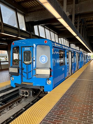
Line 3 Scarborough, originally known as Scarborough RT (SRT), was a light rapid transit line that was part of the Toronto subway system in Toronto, Ontario, Canada. The line ran entirely within the eastern district of Scarborough, encompassing six stations and 6.4 kilometres (4.0 mi) of mostly elevated track. It connected with Line 2 Bloor–Danforth at its southwestern terminus, Kennedy, and terminated in the northeast at McCowan. In 2022, the system had a ridership of 4,720,000, or about 12,300 per weekday as of the third quarter of 2023.

<span class="mw-page-title-main">Scarborough, Ontario</span> District of Toronto, Ontario, Canada

Scarborough is a district of Toronto, Ontario, Canada. It is situated atop the Scarborough Bluffs in the eastern part of the city. Its borders are Victoria Park Avenue to the west, Steeles Avenue and the city of Markham to the north, Rouge River and the city of Pickering to the east, and Lake Ontario to the south. Scarborough was named after the English town of Scarborough, North Yorkshire, inspired by its cliffs.

<span class="mw-page-title-main">Agincourt, Toronto</span> Neighbourhood in Toronto, Ontario, Canada

Agincourt is a neighbourhood and former village in Toronto, Ontario, Canada. Agincourt is located in northeast Toronto, along Sheppard Avenue between Kennedy and Markham Roads. Before the creation of the "megacity" of Toronto in 1998, the area was part of Scarborough. It is officially recognized by the City of Toronto as occupying the neighbourhoods of Agincourt South–Malvern West and Agincourt North.

<span class="mw-page-title-main">Malvern, Toronto</span> Neighbourhood in Toronto, Ontario, Canada

Malvern is a neighbourhood in the city of Toronto, Ontario, Canada, with a population of 44,315. It is located in the northeast corner of the city.

<span class="mw-page-title-main">Scarborough Centre station</span> Toronto subway station

Scarborough Centre is a bus terminal in Toronto, Ontario, Canada, serving multiple bus routes of the Toronto Transit Commission (TTC) and one Durham Regional Transit (DRT) bus route. It was also a rapid transit station serving Line 3 Scarborough of the Toronto subway system until Line 3's closure on July 24, 2023. It is located north of Ellesmere Road between Brimley and McCowan Roads, just south of Highway 401. It was adjacent to the former Scarborough Centre Bus Terminal, which was a station for GO Transit buses and other intercity coach services until the TTC modified the facility for TTC buses.

<span class="mw-page-title-main">Cancelled expressways in Toronto</span> Unbuilt freeways in Toronto, Canada

The cancelled expressways in Toronto were a planned series of expressways in Toronto, Ontario, Canada that were only partially built or cancelled due to public opposition. The system of expressways was intended to spur or handle growth in the suburbs of Toronto, but were opposed by citizens within the city of Toronto proper, citing the demolition of homes and park lands, air pollution, noise and the high cost of construction. The Spadina Expressway, planned since the 1940s, was cancelled in 1971 after being only partially constructed. After the Spadina cancellation, other expressway plans, intended to create a 'ring' around the central core, were abandoned.

<span class="mw-page-title-main">Eglinton Avenue</span> Road in Toronto and Mississauga, Canada

Eglinton Avenue is a major east–west arterial thoroughfare in Toronto and Mississauga in the Canadian province of Ontario. The street begins at Highway 407 at the western limits of Mississauga, as a continuation of Lower Baseline in Milton. It traverses the midsection of both cities and ends at Kingston Road. Eglinton Avenue is the only street to cross all six former cities and boroughs of Metropolitan Toronto.

<span class="mw-page-title-main">Morningside Avenue (Toronto)</span> Road in Toronto, Ontario, Canada

Morningside Avenue is a suburban arterial road in Toronto, Ontario, Canada. It is entirely within Scarborough, running north by north-west from the Scarborough Bluffs overlooking Lake Ontario to the eastern terminus of McNicoll Avenue near the Rouge River valley. A short extension from Steeles Avenue to Passmore Avenue has been completed but the connection to the southern section to McNicoll Avenue is still not completed.

<span class="mw-page-title-main">Kingston Road (Toronto)</span> Road in Toronto and Durham, Ontario, Canada

Kingston Road is a major arterial road in Toronto and Durham Region, Ontario. It the southernmost major (mainly) east-west road in the eastern portion of Toronto, specifically in the district of Scarborough, and runs east to Ajax in Durham. Until 1998, it formed a portion of Highway 2. The name of the street is derived from Kingston, Ontario as the road was the primary route used to travel from Toronto to the settlements east of it situated along the shores of Lake Ontario; in the west end of Kingston, the road was referred to as the York Road until at least 1908, and is today named Princess Street.

<span class="mw-page-title-main">Dufferin Street</span> Roadway in Ontario, Canada

Dufferin Street is a major north–south street in Toronto, Vaughan and King, Ontario, Canada. It is a concession road, two concessions (4 km) west of Yonge Street. The street starts at Exhibition Place, continues north to Toronto's northern boundary at Steeles Avenue with some discontinuities and continues into Vaughan, where it is designated York Regional Road 53. The street is named for Frederick Hamilton-Temple-Blackwood, 1st Marquess of Dufferin and Ava, who served as Governor General of Canada from 1872 to 1878. Prior to 1878 the street was labelled as Western City Limits or Sideline Road south off Bloor. In 2003 and 2007, it was voted as one of "Ontario's Worst 20 Roads" in the Ontario's Worst Roads poll organized by the Canadian Automobile Association.

<span class="mw-page-title-main">Markham Transit</span>

Markham Transit was a public transit system for the town of Markham, Ontario, Canada. It was created in 1973 and operated by Travelways and Miller Transit Limited after 1984 on behalf of the then Town of Markham. The service was merged into York Region Transit in 2001 with Miller Transit continuing to operate most Markham routes.

<span class="mw-page-title-main">Centennial GO Station</span> Railway station in Markham, Ontario, Canada

Centennial GO Station is a train station on the GO Transit Stouffville line in Markham, Ontario, Canada. The station is located directly west of McCowan Road and north of Bullock Drive, near the Markham Centennial Park.

Transportation in the Canadian city of Toronto forms the hub of the road, rail and air networks in the Greater Toronto Area and much of southern Ontario. There are many forms of transport in the city, including railways, highways, and public transit. Toronto also has an extensive network of bicycle lanes and multi-use trails and paths.

<span class="mw-page-title-main">Scarborough City Centre</span> Neighbourhood in Toronto, Ontario, Canada

Scarborough City Centre is a commercial district in Toronto, Ontario, Canada. It was the central business district for the former city of Scarborough, which amalgamated with Toronto in 1998. Scarborough City Centre remains one of the central business districts outside Downtown Toronto.

<span class="mw-page-title-main">Transit City</span> Proposed Toronto public transit plan

Transit City was a plan for developing public transport in Toronto, Ontario, Canada. It was first proposed and announced on 16 March 2007 by Toronto mayor David Miller and Toronto Transit Commission (TTC) chair Adam Giambrone. The plan called for the construction of seven new light rail lines along the streets of seven priority transit corridors, which would have eventually been integrated with existing rapid transit, streetcar, and bus routes. Other transit improvements outlined in the plan included upgrading and extending the Scarborough RT line, implementing new bus rapid transit lines, and improving frequency and timing of 21 key bus routes. The plan integrated public transportation objectives outlined in the City of Toronto Official Plan, the TTC Ridership Growth Strategy and Miller's 2006 election platform.

The Eglinton East LRT (EELRT), also known as Line 7 Eglinton East and formerly known as the Scarborough Malvern LRT, is a proposed light rail line in Toronto, Ontario, Canada. The line would be entirely within the district of Scarborough. It was originally part of Transit City, a plan to develop new light rail lines along several priority transit corridors in the city.

MoveOntario 2020 was a 2007 plan proposed by the Government of Ontario that would fund 52 rapid-transit projects throughout the Greater Toronto and Hamilton Area in Ontario, Canada. It was succeeded by The Big Move and GO Transit's Go 2020.

References

Commons-logo.svg Media related to Brimley Road, Toronto at Wikimedia Commons

  1. "Proposed Right-Turn Lane Designation Northbound Brimley Road at Progress Avenue" (PDF). City of Toronto. May 14, 2007. Retrieved 2007-12-29.
  2. "Classifications of City Streets" (PDF). City of Toronto. June 2000. Archived from the original (PDF) on 2008-04-11. Retrieved 2007-12-29.
  3. "T.O's un-tourist guide". Toronto Star . 2007-07-29. Retrieved 2007-12-30.
  4. "Scarborough Community Names". Scarborough Historical Society. Archived from the original on 2008-04-12. Retrieved 2007-12-29.
  5. Jeff Gray (2005-07-01). "Report finds shortchanged neighbourhoods" (fee required). The Globe and Mail . Retrieved 2007-12-30.
  6. "Scarborough-Agincourt". Elections Ontario. 2007. Archived from the original on 2007-10-04. Retrieved 2007-12-30.
  7. "Scarborough-Rouge River". Elections Ontario. 2007. Archived from the original on 2007-10-04. Retrieved 2007-12-30.
  8. Abbate, Gay (December 17, 1987). "Stage set for final battle on Brimley, 401 overpass". The Globe and Mail . p. A23.
  9. "Committee votes to open Brimley Road". The Globe and Mail . February 19, 1988. p. A13.
  10. "Bus Routes" . Retrieved 2018-12-09.
  11. "Route 175" . Retrieved 2021-06-01.
  12. Gary Webster (2007-02-27). "Staff Response to Commission Inquiry – Scarborough RT Strategic Plan". Toronto Transit Commission . Retrieved 2008-01-04.
  13. "TTC Minutes - February 27, 2008" (PDF). Retrieved 2008-03-30.
  14. City of Toronto: Scarborough Historical Museum