Agincourt, Toronto

Last updated

Agincourt
Neighbourhood
Agincourt Aerial View 2023.jpg
Aerial view of Agincourt in 2023
Agincourt map.PNG
Vicinity
Toronto map.png
Red pog.svg
Location within Toronto
Coordinates: 43°47′33″N79°17′02″W / 43.79250°N 79.28389°W / 43.79250; -79.28389 [1]
CountryCanada
Province Ontario
CityToronto
Municipality established1850 Scarborough Township
Postal village1858
Joined1953 Metropolitan Toronto
Government
   MP Shaun Chen (L) (Scarborough North)
Jean Yip (L) (Scarborough—Agincourt)
   MPP Raymond Cho (PC) (Scarborough North)
Aris Babikian (PC) (Scarborough—Agincourt)
   Councillor Nick Mantas (Ward 22 Scarborough—Agincourt)
Jamaal Myers (Ward 23 Scarborough North)

Agincourt ( /ˈ.ɪn.kɔːrt/ ) is a neighbourhood and former village in Toronto, Ontario, Canada. Agincourt is located in northeast Toronto, along Sheppard Avenue between Kennedy and Markham Roads (north-south includes lands between Highway 401 and Finch Avenue). Before the creation of the "megacity" of Toronto in 1998, the area was part of Scarborough. It is officially recognized by the City of Toronto as occupying the neighbourhoods of Agincourt South–Malvern West and Agincourt North.

Contents

The name Agincourt is often used to refer to a larger area of northwest Scarborough rather than just the officially recognized neighbourhood. The area to the west of Agincourt, officially named Tam O'Shanter–Sullivan is often included as part of Agincourt, and the Agincourt Mall is located in Tam O'Shanter.

The section of Agincourt west of Midland Avenue belongs to the electoral district of Scarborough—Agincourt, while the section to the east is part of Scarborough North (federal, previously Scarborough—Rouge River) or Scarborough—Rouge River (provincial, until the 2018 provincial election, when it will be replaced with Scarborough North).

History

Agincourt Public School was established in 1914. Agincourt Collegiate Institute would occupy the second floor from 1915 to 1929. ScarboroughAgincourtSchool.jpg
Agincourt Public School was established in 1914. Agincourt Collegiate Institute would occupy the second floor from 1915 to 1929.

Agincourt was once referred to as "hero town" by the citizens that lived there. The village of Agincourt was officially founded with the establishment of the Agincourt post office, opened in June 1858 by John Hill. The name of the settlement was after the site of Henry V's decisive English victory over French forces in 1415. Local legend has it that the town's name was chosen when Hill requested that the town be given a post office, and the French-Canadian Postmaster agreed, on the condition that it be given a French name, with 'Agincourt' chosen to undermine the Postmaster's intention. [2] The site of the 1415 battle is now known as Azincourt: the namesake of today's Agincourt, Ontario should not be confused with Agincourt, Meurthe-et-Moselle. The original crossroads of Agincourt is located at Midland Avenue and Sheppard and served a rural agricultural population.

Agincourt from Kennedy Road and Village Green Square Village Green Square 2023.jpg
Agincourt from Kennedy Road and Village Green Square

A Presbyterian church (from France[ citation needed ]) was built on the north-east corner, which is today's Knox United Church. In addition, an Agincourt Public School was built in 1914, which has evolved over time into Agincourt Junior Public School. A secondary school that later evolved into Agincourt Collegiate Institute, was established in 1915 on the second floor of the same building. From 1954 to 1998, the schools were a part of the Scarborough Board of Education.

Two railway stations were constructed in the second half of the 19th century at Agincourt. One was built just west of the crossroads as part of the Toronto and Nipissing Railway line heading north from Scarborough Junction on the Toronto Montreal mainline, and greatly improved access. The line eventually became part of Canadian National Railways, and the station operates today as Agincourt Station on the GO Transit Stouffville commuter rail route. A second station was built east of the crossroads, northside of Sheppard Avenue and west of Brimley Road, on what is today CP Rail track that runs from downtown Toronto diagonally northeast through the neighbourhood. Commuter rail service to Toronto's Union Station was offered by the CPR from various service routes such as Lake Ontario Shore Line and Toronto-Peterboro Dayliner (1950s). CP passenger service was discontinued in 1982 but revived briefly in 1985 before being cancelled for good in 1990. The line branches east of a marshalling yard, built by CP in the 1960s between McCowan and Markham Roads on the east of the neighbourhood, into the (Peterborough–) Havelock and Belleville (– Montreal) subdivisions. The neighbourhood saw an influx of Chinese Canadians move into the area during the 1980s.

Agincourt saw an influx of Hong Kong Chinese and Taiwanese emigrants during the 1980s, especially in the area along Sheppard Avenue near Midland Avenue. Since the development of Chinese-themed shopping centres in the 1980s, it has become a booming suburban Toronto Chinatown and was the vanguard for the proliferation of "Chinese malls", catering specifically to the Chinese community across the GTA. [3]

Economy

Agincourt Mall, an enclosed mall, began a redevelopment in 2018, and is the second-largest active residential application in Toronto. [4]

Education

Agincourt Junior Public School, erected in 1915. Agincourt Junior Public School.jpg
Agincourt Junior Public School, erected in 1915.
Agincourt Collegiate Institute is a public secondary school located in Agincourt. Agincourt Collegiate Institute.JPG
Agincourt Collegiate Institute is a public secondary school located in Agincourt.

Four public school boards operate elementary and secondary schools in Agincourt. They include the public secular Toronto District School Board (TDSB), and the public separate school boards, Conseil scolaire catholique MonAvenir (CSCM), and the Toronto Catholic District School Board (TCDSB). Toronto's French-language secular public school board, Conseil scolaire Viamonde (CSV) now operates a school in the district.

TDSB operates four public secondary schools in the neighbourhood, Agincourt Collegiate Institute, Albert Campbell Collegiate Institute, Sir William Osler High School and Delphi Alternative Secondary School. In addition to secondary schools, TDSB also operates institutions which provide primary education. TCDSB operates two public secondary schools in Agincourt, Francis Libermann Catholic High School and Monsignor Fraser College Midland Campus, with the latter housed in the former Our Lady of Good Counsel Catholic School.

The following public elementary schools operate in Agincourt (with the managing school board in parentheses):

Recreation

The neighbourhood is home to a number of municipal parks, managed by the Toronto Parks, Forestry and Recreation Division. In addition to local parks, the Division also operates the Agincourt Recreation Centre (pool and ice rink - damaged in fire in January 2019), located adjacent to Agincourt Park, Albert Campbell Pool (inside Albert Campbell CI) and Commander Park Arena (ice rink) at Commander Park.

See also

Related Research Articles

<span class="mw-page-title-main">Bendale</span> Neighbourhood in Toronto, Ontario, Canada

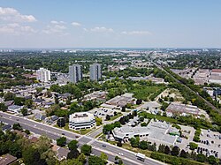
Bendale, also called Cedarbrae and Midland Park, is a residential neighbourhood in the eastern part of Toronto, Ontario, Canada. It is located in the former suburb of Scarborough. It is centred on the intersection of Lawrence Avenue East and Brimley Road. Its boundaries, as defined by the City, are Midland Avenue from Lawrence, north to Highway 401, east to McCowan, south to Lawrence, east to West Highland Creek, south-west along West Highland Creek, then follow several side streets parallel to the Creek, north to Midland Avenue. The area north of Ellesmere is typically considered the Scarborough City Centre district, and is not considered in this neighbourhood article.

<span class="mw-page-title-main">Port Union, Toronto</span> Neighbourhood in Toronto, Ontario, Canada

Port Union, also known as Centennial Scarborough is a neighbourhood in Toronto, Ontario, Canada. It is located in the south-east corner of Toronto, within the former suburb of Scarborough. The neighbourhood is bounded by Kingston Road to the north, Port Union Road to the east, the Lake Ontario shoreline to the south, and Highland Creek to the west.

<span class="mw-page-title-main">Malvern, Toronto</span> Neighbourhood in Toronto, Ontario, Canada

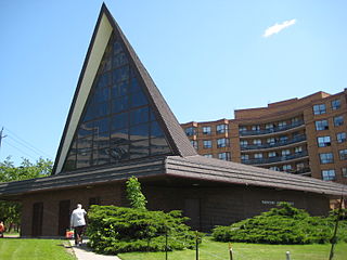
Malvern is a neighbourhood in the city of Toronto, Ontario, Canada, with a population of 44,315. It is located in the northeast corner of the city.

<span class="mw-page-title-main">Scarborough Village</span> Neighbourhood in Toronto, Ontario, Canada

Scarborough Village is a neighbourhood in Toronto, Ontario, Canada, located in the Scarborough district. It was one of the earliest settlements in the former township of Scarborough with the distinction of being the site of the township's first post office. Today, the neighbourhood is composed of private and public housing, apartment complexes, schools, a few condominiums, and strip mall plazas. The neighbourhood lies along the Scarborough Bluffs escarpment.

<span class="mw-page-title-main">Richview, Toronto</span> Neighbourhood in Toronto, Ontario, Canada

Richview, formally known as Willowridge-Martingrove-Richview, is a neighbourhood in the city of Toronto, Ontario, Canada. It is bounded on the west by Highway 401 and on the north by the highway and by Dixon Road, Royal York Road on the east, and Eglinton Avenue West along the south. Richview was originally established as a postal village within the then-agricultural Etobicoke Township, which later became the suburb of Etobicoke.

<span class="mw-page-title-main">Milliken, Ontario</span> Neighbourhood in Ontario, Canada

Milliken and Milliken Mills are neighbourhoods in the cities of Toronto and Markham. Milliken is situated in the north west section of Scarborough, whereas Milliken Mills is situated in the south-central portions of Markham. The neighbourhoods are centered on Kennedy Road and Steeles Avenue, the latter street serving as the boundary between the cities of Markham and Toronto.

<span class="mw-page-title-main">Humbermede</span> Neighbourhood in Toronto, Ontario, Canada

Humbermede, often called Emery, is a neighbourhood of Toronto, Ontario, Canada. Humbermede, like many of the "Humber" neighbourhoods in the city, gets its name from the Humber River. It is bounded on the west by the Humber River, on the north by Finch Avenue West, on the east by the Highway 400 and on the south by Sheppard Avenue West.

<span class="mw-page-title-main">Clanton Park, Toronto</span> Neighbourhood in Toronto, Ontario, Canada

Clanton Park is a neighbourhood in Toronto, Ontario, Canada. Located in the district of North York, it is part of federal and provincial electoral district York Centre, and Toronto electoral wards 9: York Centre (West) and 10: York Centre (East). In 2016, it had a population of 16,472, a 12.7% rise from 2011.

<span class="mw-page-title-main">Parkwoods</span> Neighbourhood in Toronto, Ontario, Canada

Parkwoods or sometimes referred to as Parkwoods-Donalda, is a neighbourhood in Toronto, Ontario, Canada. It is a geographically large neighbourhood located just south of Ontario Highway 401, west of Victoria Park Avenue, north of Lawrence Avenue East and east of the Don Valley Parkway.

<span class="mw-page-title-main">Pleasant View, Toronto</span> Neighbourhood in Toronto, Ontario, Canada

Pleasant View is a neighbourhood in the city of Toronto, Ontario, Canada that is located in the district of North York at the northern end of the city. It is bordered by Victoria Park to the East, Sheppard Avenue to the South, Highway 404 to the west and the Finch hydro corridor to the north. The neighbourhood is home to several high-rise apartment and condominium buildings, such as The Clippers.

<span class="mw-page-title-main">Don Valley Village</span> Neighbourhood in Toronto, Ontario, Canada

Don Valley Village is a neighbourhood in the city of Toronto, Ontario, Canada. It is located in the former suburb of North York. Located north of Highway 401 and bisected by Don Mills Road, it is bounded by Sheppard Avenue to the south, Leslie Street to the west, Finch Avenue to the north and Highway 404 to the east. Like the nearby Don River Valley, the neighbourhood has hill and dale topography.

<span class="mw-page-title-main">Steeles, Toronto</span> Neighbourhood in Toronto, Ontario, Canada

Steeles is a suburban neighbourhood in Toronto, Ontario, Canada. Steeles is located in the north-eastern part of Toronto in the former suburb of Scarborough. To the north is bordered by Steeles Avenue East, to the east by Kennedy Road, to the south by a hydro-electric transmission line and to the west by Victoria Park Avenue.

<span class="mw-page-title-main">L'Amoreaux</span> Neighbourhood in Toronto, Ontario, Canada

L'Amoreaux is a neighbourhood in Toronto, Ontario, Canada, situated east of Victoria Park Avenue, south of McNicoll Avenue, west of Kennedy Road and north of Huntingwood Drive. L'Amoreaux is named after Josue L'Amoreaux (1738–1834), a French Huguenot loyalist who settled in the area. Prior to the amalgamation of Toronto in 1998, L'Amoreaux was a neighbourhood of the former city of Scarborough, and prior to the amalgamation of municipalities, it formed part of the town of Agincourt.

<span class="mw-page-title-main">Tam O'Shanter-Sullivan</span> Neighbourhood in Toronto, Ontario, Canada

Tam O'Shanter-Sullivan is a neighbourhood in the east end of the city of Toronto, Ontario, Canada, in the district of Scarborough. The neighbourhood is bordered by Huntingwood Drive to the North, Kennedy Road to the East, Highway 401 to the South and Victoria Park to the West. The neighbourhood, which includes the Tam O'Shanter and Sullivan communities, takes its name from Tam O’Shanter Golf Course and O'Sullivan's Corners.

<span class="mw-page-title-main">Scarborough Junction</span> Neighbourhood in Toronto, Ontario, Canada

Scarborough Junction is a small neighbourhood in the Scarborough district of Toronto, Ontario, Canada. It is bordered by Birchmount Road, Brimley Road, Eglinton Avenue, and St. Clair Avenue. Scarbrough Junction has an approximated population of 20,000. The population consists of 1/4 Caucasian, 2/4 Asian and 1/4 other

<span class="mw-page-title-main">Dorset Park</span> Neighbourhood in Toronto, Ontario, Canada

Dorset Park is a neighbourhood in Toronto, Ontario, Canada. It is located in the western part of the district of Scarborough. The neighbourhood is bordered by Highway 401 to the north, Midland Avenue to the east, Lawrence Avenue to the south, and Birchmount Road to the west. Kennedy Road runs along the neighbourhood's centre north and south and Ellesmere Road runs along the centre east and west. The area south of Lawrence Avenue, north of the hydro corridor, is known as McGregor Park and is often included as part of Dorset Park.

<span class="mw-page-title-main">Rouge, Toronto</span> Neighbourhood in Toronto, Ontario, Canada

Rouge is a neighbourhood in the northeastern area of Toronto, Ontario, within the former city of Scarborough. It is Toronto's largest neighbourhood by surface area; however, unlike other neighbourhoods, most of its area remains undeveloped, as the neighbourhood is adjacent to Rouge National Urban Park.

<span class="mw-page-title-main">Morningside, Toronto</span> Neighbourhood in Toronto, Ontario, Canada

Morningside, also known as Seven Oaks, is a suburban neighbourhood in the city of Toronto, Ontario, Canada. It is located to the north-east of downtown Toronto, in the suburb of Scarborough. Morningside is bordered by Highway 401 to the north, Morningside Avenue to the east, West Highland Creek and Lawrence Avenue to the south and Scarborough Golf Club Road to the west.

<span class="mw-page-title-main">Woburn, Toronto</span> Neighbourhood in Toronto, Ontario, Canada

Woburn is a neighbourhood located in eastern Toronto, Ontario, Canada, in the former suburb of Scarborough. Woburn is bordered by Highway 401 to the north, Orton Park Road to the east, Lawrence Avenue to the south, and McCowan Road to the west.

<span class="mw-page-title-main">Eglinton East</span> Neighbourhood in Toronto, Ontario, Canada

Eglinton East, historically known as Knob Hill, is a residential and commercial neighbourhood in Toronto, Ontario, Canada. It is bounded by Stansbury Crescent, Citadel Drive, and West Highland Creek to the north, Midland Avenue to the west, the CNR rail line, Brimley Road, and Eglinton Avenue to the south, and Bellamy Road North to the east.

References

  1. "Agincourt". Geographical Names Data Base . Natural Resources Canada . Retrieved August 21, 2017.
  2. As taught to students at Agincourt Collegiate Institute in 10th Grade history, 1992
  3. Liu, Karon (August 21, 2019). "Dragon Centre was a catalyst for Scarborough's Chinese community, but the history is not all rosy | The Star". thestar.com. Retrieved November 10, 2019.
  4. D'Andrea, Aaron (February 23, 2018). "Huge mixed-use development planned for Scarborough's Agincourt Mall". Toronto.com. Retrieved October 1, 2018.