Discovery District

Last updated

Discovery District
Neighbourhood
University of Toronto aerial view.jpg
Discovery District comprising the vicinity of the University of Toronto and its research hospitals, visible from the CN Tower
Discovery District map.PNG
The area on University Avenue is the core of the Discovery District. The campus of the University of Toronto to the north can also be included
CountryFlag of Canada (Pantone).svg  Canada
Province Flag of Ontario.svg  Ontario
City Toronto
Government
   MP Chrystia Freeland (University-Rosedale)
   MPP Han Dong (Trinity—Spadina)
   Councillor Joe Cressy (Ward 20 Trinity—Spadina)

The Discovery District is one of the commercial districts in Downtown Toronto, Ontario, Canada. It has a high concentration of hospitals and research institutions, particularly those related to biotechnology. The district is roughly bounded by Bloor Street on the north, Bay Street on the east, Dundas Street on the south, and Spadina Avenue on the west.

Contents

Characteristics

The area includes the main campuses of the University of Toronto and Toronto Metropolitan University, as well as university affiliated health-care research hospitals including the Hospital for Sick Children, Toronto General Hospital, Princess Margaret Cancer Centre, Mount Sinai Hospital, Toronto Rehabilitation Institute Women's College Hospital, and the MaRS Discovery District. These institutions are concentrated near the intersection of University Avenue and College Streets but the District generally extends north to Bloor Street, south to Dundas Street, east to Bay Street and West to Spadina Avenue. A number of key organizations within the Ontario life sciences community are also located here including Ontario Genomics, Ontario Bioscience Innovation Organization (OBIO), Toronto Innovation Acceleration Partners (TIAP) and JLabs Toronto.

MaRS Discovery District is also home to several research institutes and life sciences organizations including the Centre for Commercialization of Regenerative Medicine (CCRM) and artificial intelligence companies including the Vector Institute and Deep Genomics. MaRSfromCollege.jpg
MaRS Discovery District is also home to several research institutes and life sciences organizations including the Centre for Commercialization of Regenerative Medicine (CCRM) and artificial intelligence companies including the Vector Institute and Deep Genomics.

History: this area was subdivided from three main 'park lot' estates: Macaulay Estate (to the east, became a residential district known as 'the Ward' until demolished), Elmsley Estate (redivided with the Macaulay Estate which was concentrated to the south. Elmsley estate is closely tied with the history of both the University of Toronto and the commercial district on Yonge Street) and the Powell Estate (became the 'University Park' now the University of Toronto)

A short stretch of Gerrard Street West from Bay Street to LaPlante Avenue was referred to as Gerrard Village, a Bohemian Greenwich Village like area from the late 19th century to the early 1970s.

This area is referred to by Statistics Canada as census tract 5350035.00. According to the 2011 National Household Survey, 80% of the population surveyed reported an income of over $50 000 annually. This is almost 30% higher than the average provincial income. For the total 2011 population within the discovery district 395 people made between $30 000 and $39 000 annually, 410 made between $40 000 and $49 000, and 2250 made over $50 000. The accuracy of these figures is questionable due to the National Household Survey being optional, and therefore wealthier people could possibly be over represented. But considering the location in the heart of downtown Toronto and the rapid expansion of condominium build ups, people would have to make more money to live here.

Statistics Canada. National Household Survey 2011

History

The original plans for the Town of York (later City of Toronto) divided the City along Lot Street (Queen Street) with a street grid creating small urban 'town lots' to the south and large rectangular 'park lots' (farms) to the north. The 'park lots' along Lot St (Queen) were given to many of York's (Toronto's) most prominent families who had professions and sometimes even a separate house in the Town and generally did not farm; therefore they often did not clear their lots of the natural forest. As each 'park lot' extended in a rectangle from Lot Street (Queen) to what would become Bloor, [1] most of the estate houses were built on the north side of Lot Street opposite the Town. Four 'park lots' (numbers 9 to 12) comprised the area north of Queen just across from the heart of Toronto between Yonge Street and just west of College Avenue (now University Ave). Three of the families occupying these lots built large estate homes all fairly far north of Lot St (Queen):

Osgoode Hall was completed in 1834, and presently houses the Law Society of Ontario. Exterior view, Osgoode Hall - Toronto, Canada - DSC00382.jpg
Osgoode Hall was completed in 1834, and presently houses the Law Society of Ontario.

The situation of these lots just north of the town meant that this land was in high demand as the city outgrew its original boundaries south of Lot (Queen). As most Toronto streets started at Lot (Queen), the 'park lots' commanded impressive views into the town and many of the buildings that were built as the 'park lots' were subdivided by their owner, were impressive institutions such as Osgoode Hall (Upper Canada's Law Courts) still standing, built at the top of York Street by 1832 just two years before the Town of York became a City with the name Toronto. By the time Toronto became a city in 1834, the area south of Lot St (Queen) from the Garrison Creek to the Don River had all been subdivided and the four 'park lots' north of Lot St (Queen) were subdivided by their owners with the eastern lot (Macaulay's estate) becoming the first residential district north of Queen, the western lot (Powell's estate) becoming the 'University Park', gated parkland intended to become Toronto's University [5] and the area between on the north side of Lot St (Queen) attracting various institutions and businesses.

Development

The area just north of Lot St (Queen) became something of an institutional area with buildings such as the House of Industry (still standing), [6] the Armoury (behind Osgoode Hall, now demolished for the University Avenue Court Houses) and the Eaton's Company store to the south (creating 'the cavern' with the Hudson Bay building on the south of Queen St) and the University of Toronto in the 'University Park' to the north which was gated at Queen St & College Ave (University Ave) and was largely forested.

It was also part of the City Liberties identified in James Cane's 1842 map. It was bounded roughly by Bloor, Don River, Dundas and Bathurst.

In the early 1900s, The Ward, an economically depressed neighbourhood was demolished. The Ward as viewed from Eaton factory.jpg
In the early 1900s, The Ward, an economically depressed neighbourhood was demolished.

By about 1900 there still remained a large residential district called 'The Ward' which became Toronto's first Chinatown but also attracted many attempts to have it demolished as it was economically depressed. At this time some of Toronto's oldest and most important institutions south of Queen were replaced with larger buildings north of Queen St such as Old City Hall (called 'New' City Hall at this time) at the top of Bay Street [7] and the Ontario Parliament Building; Queen's Park on the university grounds at the top of College Avenue (renamed University Ave).

Part of 'The Ward' had been demolished for the building of New City Hall (Now Old City Hall) and in the years after the first world war, several plans were made to more closely link the institutional area north of Queen with the older town to the south. Two plans in particular substantially changed this area although both ultimately collapsed with the Great Depression. University Avenue was extended south of Queen street although the street itself, formerly a large quiet street leading to Queen's Park and the 'University Park' was only slowly turned into the bustling Boulevard of towers and hospitals it is today, none of the Art Deco towers originally planned for the street were ever built. The second plan called for a new 'Federal Avenue' in the middle of the old town's grid (between Bay and York Streets) starting from the new Union Station north to a proposed Government complex on the north side of Queen. [8] Many buildings in 'The Ward' were purchased by the government before the plan fell through. In the 1960s with the City of Toronto annexing the last independent municipalities, 'The Ward' was demolished and a new City Hall was built on the north side of Queen Street between what became Old City Hall and Osgoode Hall. [9]

Related Research Articles

<span class="mw-page-title-main">The Annex</span> Neighbourhood in Toronto, Ontario, Canada

The Annex is a neighbourhood in Downtown Toronto, Ontario, Canada. The traditional boundaries of the neighbourhood are north to Dupont Street, south to Bloor Street, west to Bathurst Street and east to Avenue Road. The City of Toronto recognizes a broader neighbourhood definition that includes the adjacent Seaton Village and Yorkville areas.

<span class="mw-page-title-main">The Kingsway, Toronto</span> Neighbourhood in Toronto, Ontario, Canada

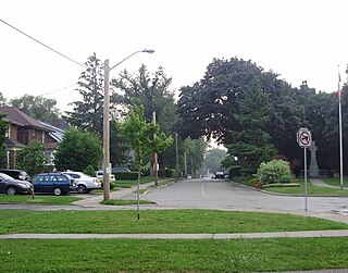
The Kingsway is a residential neighbourhood in Toronto, Ontario, Canada. It is bounded by Bloor Street to the south, Dundas Street to the north, the Mimico Creek to the west and the Humber River to the east. The neighbourhood was officially known as Kingsway Park, which later became replaced by its nickname, The Kingsway. For planning purposes, the neighbourhood is known by the City of Toronto as "Kingsway South" to differentiate it from a more recent extension of The Kingsway north of Dundas Street. "Kingsway South" is not used by residents, due to confusion with the South Kingsway, a street located east of the Humber River and extending south from Bloor Street.

<span class="mw-page-title-main">Swansea, Toronto</span> Neighbourhood in Toronto, Ontario, Canada

Swansea is a neighbourhood in the city of Toronto, Ontario, Canada, bounded on the west by the Humber River, on the north by Bloor Street, on the east by High Park and on the south by Lake Ontario. The neighbourhood was originally a separate municipality, the Village of Swansea, which became part of Metropolitan Toronto in 1953.

<span class="mw-page-title-main">Roncesvalles, Toronto</span> Neighbourhood in Toronto, Ontario, Canada

Roncesvalles is a neighbourhood in the city of Toronto, Ontario, Canada, centred on Roncesvalles Avenue, a north–south street leading from the intersection of King and Queen Streets to the south, north to Dundas Street West, a distance of roughly 1.7 kilometres. It is located east of High Park, north of Lake Ontario, in the Parkdale–High Park provincial and federal ridings and the municipal Ward 4. Its informal boundaries are High Park to the west, Bloor Street West to the north, Lake Ontario/Queen Street West to the south and Lansdowne Avenue/rail corridor to the east. Originally known as "Howard Park", most of this area was formerly within the boundaries of Parkdale and Brockton villages and was annexed into Toronto in the 1880s.

<span class="mw-page-title-main">Mimico</span> Neighbourhood in Toronto, Ontario, Canada

Mimico is a neighbourhood in Toronto, Ontario, Canada, being located in the south-west area of Toronto on Lake Ontario. It is in the south-east corner of the former Township of Etobicoke, and was an independent municipality from 1911 to 1967.

<span class="mw-page-title-main">Deer Park, Toronto</span> Neighbourhood in Toronto, Ontario, Canada

Deer Park is a neighbourhood in Toronto, Ontario, Canada. It is centered on the intersection of Yonge Street and St. Clair Avenue and its boundaries are the Vale of Avoca section of Rosedale ravine in the east, Farnham Avenue and Jackes Avenue in the south, Avenue Road and Oriole Parkway in the west, the Beltline Trail in the north on the west side of Yonge Street, and Glen Elm Avenue in the north on the east side of Yonge Street. For the purposes of social policy analysis and research, the Toronto government’s Social Development & Administration division includes Deer Park within the City of Toronto's official "Rosedale-Moore Park" and "Yonge-St.Clair" neighbourhood profiles. The neighbourhood is in Ward 22, represented by Councillor Josh Matlow at Toronto City Council.

<span class="mw-page-title-main">Yorkville, Toronto</span> Neighbourhood in Toronto, Ontario, Canada

Yorkville is a neighbourhood and former village in Toronto, Ontario, Canada. It is roughly bounded by Bloor Street to the south, Davenport Road to the north, Yonge Street to the east and Avenue Road to the west, and it is part of The Annex neighbourhood. Established as a separate community in 1830, it was annexed into Toronto in 1883. Yorkville comprises residential areas, office space, and retail shopping.

<span class="mw-page-title-main">Bloor Street</span> Major thoroughfare in Toronto

Bloor Street is a major east–west residential and commercial thoroughfare in Toronto, Ontario, Canada. Bloor Street runs from the Prince Edward Viaduct, which spans the Don River Valley, westward into Mississauga where it ends at Central Parkway. East of the viaduct, Danforth Avenue continues along the same right-of-way. The street, approximately 25 kilometres (16 mi) long, contains a significant cross-sample of Toronto's ethnic communities. It is also home to Toronto's famous shopping street, the Mink Mile.

<span class="mw-page-title-main">Government House (Ontario)</span>

Government House was the official residence of the lieutenant governor of Upper Canada and Ontario, Canada. Four buildings were used for this purpose, none of which exist today, making Ontario one of four provinces not to have an official vice-regal residence.

<span class="mw-page-title-main">Garden District, Toronto</span> Neighbourhood in Toronto, Ontario, Canada

The Garden District is a neighbourhood in downtown Toronto, Ontario, Canada. The name was selected by the Toronto East Downtown Residents Association (TEDRA) in recognition of Allan Gardens, an indoor botanical garden located nearby at the intersection of Carlton and Jarvis Streets. The Garden District was officially designated by the Mayor and Toronto City Council in 2001, while TEDRA has since been renamed the Garden District Residents Association. Part of the neighbourhood is within official City of Toronto neighbourhood of Moss Park.

<span class="mw-page-title-main">Niagara, Toronto</span> Neighbourhood in Toronto, Ontario, Canada

Niagara is a neighbourhood in Toronto, Ontario, Canada, located south of Queen Street West; it is usually bordered by Strachan Avenue to the west, Bathurst Street to the east, and the railway corridor to the south, and so named because Niagara Street runs through the centre of it. The eastern portion of this area was first planned as the New Town Extension when Toronto was incorporated as a city. The area was developed as a residential area for the workers of industries located along the CN and CP railway corridors. It remains a working-class neighbourhood that has seen the development of new condominium apartment buildings.

<span class="mw-page-title-main">Brockton Village</span> Neighbourhood in Toronto, Ontario, Canada

Brockton Village is a former town, and now the name of a neighbourhood, in Toronto, Ontario, Canada. It comprises a section of the old Town of Brockton which was annexed by the City of Toronto in 1884.

<span class="mw-page-title-main">Old Toronto</span> Dissolved city in Ontario, Canada

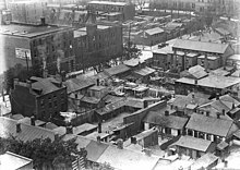
Old Toronto is the part of Toronto, Ontario, Canada, that corresponds to the boundaries of the City of Toronto prior to 1998. It was incorporated as a city in 1834, after being known as the town of York, and being part of York County. Toronto periodically grew in size by annexing adjacent land and municipalities.

<span class="mw-page-title-main">High Park North</span> Neighbourhood in Toronto, Ontario, Canada

High Park North, or often simply High Park, after the park, is a neighbourhood in Toronto, Ontario, Canada. It is bounded on the south by Bloor Street, on the west by Runnymede Road, on the north by Annette Street, Quebec Avenue and Humberside Avenue, and on the east by the GO Transit Weston Subdivision rail tracks. It is located in the Parkdale—High Park provincial and federal electoral districts. The area east of Keele Street is also known informally as the "West Bend" neighbourhood.

<span class="mw-page-title-main">History of neighbourhoods in Toronto</span>

Throughout its history, Toronto has been a city divided into many districts and neighbourhoods. As the city has grown, new neighbourhoods have been created by expansion of the city into the countryside. Over time, the neighbourhoods within existing areas have also been altered and rearranged.

<span class="mw-page-title-main">Dundas Street</span> Major arterial road in Ontario, Canada

Dundas Street is a major historic arterial road in Ontario, Canada. The road connects the city of Toronto with its western suburbs and several cities in southwestern Ontario. Three provincial highways—2, 5, and 99—followed long sections of its course, although these highway segments have since been downloaded to the municipalities they passed through. Originally intended as a military route to connect the shipping port of York to the envisioned future capital of London, Ontario, the street today connects Toronto landmarks such as Yonge–Dundas Square and the city's principal Chinatown to rural villages and the regional centres of Hamilton and London.

References

  1. The Estates of Old Toronto, Liz Lundell, 1997. ISBN   1-55046-219-9
  2. The Estates of Old Toronto, Liz Lundell, 1997. ISBN   1-55046-219-9, Pg 26
  3. The Estates of Old Toronto, Liz Lundell, 1997. ISBN   1-55046-219-9, Pg 24
  4. The Estates of Old Toronto, Liz Lundell, 1997. ISBN   1-55046-219-9, Pg 18
  5. Toronto: City Life Old & New, Mike Filey, 1979. ISBN   0-919324-40-1 Pg 46
  6. "House of Industry | Heritage Toronto - Telling Toronto's Stories". Archived from the original on 2011-05-27. Retrieved 2009-02-13.
  7. Toronto: City Life Old & New, Mike Filey, 1979. ISBN   0-919324-40-1 Pg 30
  8. Historical Atlas of Toronto, Derek Hayes, 2008, ISBN   978-1-55365-290-8, Pg 138
  9. Torontoist (11 October 2008). "Historicist: Forgotten Urban Squalor of The Ward". torontoist.com. Retrieved 20 April 2018.

43°39′29″N79°23′17″W / 43.658°N 79.388°W / 43.658; -79.388