This article possibly contains original research .(May 2011) |
Uptown Toronto is an area in Toronto, Ontario, Canada that is considered to be north of Midtown Toronto.
This article possibly contains original research .(May 2011) |
Uptown Toronto is an area in Toronto, Ontario, Canada that is considered to be north of Midtown Toronto.

"Uptown" has traditionally been a name given to the area north of Downtown Toronto. As the portion of the city that could be considered to be downtown or midtown has grown, the region has pushed further north along Yonge Street.
The first area known as Uptown was centered on Bloor Street around the University of Toronto. In the nineteenth century, this was the northern fringe of the city; when the university was established it was still largely rural. The neighborhood that grew up in this area in the late nineteenth and early twentieth century became known as Uptown. While this name is no longer used, it was preserved in some institutions, such as the Uptown Residences, a condo on the site of the former Uptown Theatre.
Most areas north of Bloor have been referred to as Uptown. Today the area most often refers to the northern portion of the old city of Toronto stretching from St. Clair Avenue to Lawrence Avenue. There is no official city of Toronto definition for Uptown, but the Uptown Yonge Business Improvement area stretches from Eglinton to Lawrence, [1] though today, with the amalgamated city, the North York City Centre, along Yonge Street, an area dense with highrises, could best be described as Uptown.

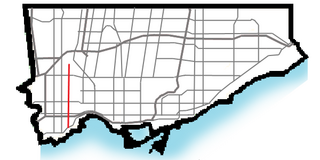
Yonge Street is a major arterial route in the Canadian province of Ontario connecting the shores of Lake Ontario in Toronto to Lake Simcoe, a gateway to the Upper Great Lakes.
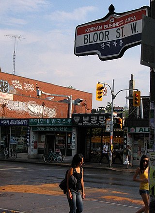
Koreatown is an ethnic enclave within Seaton Village, a neighbourhood of Toronto, Ontario, Canada. Located along Bloor Street between Christie and Bathurst Streets, the area is known for its Korean business and restaurants. The ethnic enclave developed during the 1970s, as the city experienced an influx of Korean immigrants settling in Toronto. Toronto has the largest single concentration of Koreans in Canada with 53,940 living in the city, according to the Canada 2016 Census.

Yonge–Eglinton is a neighbourhood in Toronto, Ontario, Canada, at the intersection of Yonge Street and Eglinton Avenue. It is central to the area of Midtown Toronto, one of four central business districts outside Downtown Toronto. The City of Toronto defines its boundaries as Briar Hill Avenue to the north, Yonge Street to the east, Frobisher Avenue and a line in that direction west to Elmsthorpe Avenue, then north to Eglinton Avenue, east to Avenue Road and north to Briar Hill.

North Toronto is a former town and informal district located in the northern part of the Old Toronto district in Toronto, Ontario, Canada. Currently occupying a geographically central location within the city of Toronto, the Town of North Toronto was incorporated in 1890, when much of the area was still farmland, and annexed by Toronto in 1912. The name is still used to refer to the area in general, although Yonge–Eglinton and Midtown Toronto are officially used.

Trinity—Spadina was a federal electoral district in Ontario, Canada, that was represented in the House of Commons of Canada from 1988 to 2015.

Spadina Avenue is one of the most prominent streets in Toronto, Ontario, Canada. Running through the western section of downtown, the road has a very different character in different neighbourhoods.

Toronto—St. Paul's is a federal electoral district in Toronto, Ontario, Canada, that has been represented in the House of Commons of Canada since 1935. Its current MP is Carolyn Bennett. Prior to the 2015 election, the riding was known as St. Paul's.

Bloor Street is a major east–west residential and commercial thoroughfare in Toronto, Ontario, Canada. Bloor Street runs from the Prince Edward Viaduct, which spans the Don River Valley, westward into Mississauga where it ends at Central Parkway. East of the viaduct, Danforth Avenue continues along the same right-of-way. The street, approximately 25 kilometres (16 mi) long, contains a significant cross-sample of Toronto's ethnic communities. It is also home to Toronto's famous shopping street, the Mink Mile.

Bathurst Street is a main north–south thoroughfare in Toronto, Ontario, Canada. It begins at an intersection of the Queens Quay roadway, just north of the Lake Ontario shoreline. It continues north through Toronto to the Toronto boundary at Steeles Avenue. It is a four-lane thoroughfare throughout Toronto. The roadway continues north into York Region where it is known as York Regional Road 38.

Keele Street is a north–south road in Toronto, Vaughan and King in Ontario, Canada. It stretches 47 kilometres (29 mi), running from Bloor Street in Toronto to the Holland Marsh. South of Bloor Street, the roadway is today known as Parkside Drive, but was originally part of Keele Street. It was renamed in 1921 by the City of Toronto.
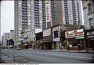
The Uptown Theatre was a historic movie theatre in Toronto, Ontario which was demolished in 2003. The entrance to the theatre was located on Yonge Street just south of Bloor. Like many theatres of the time it was constructed so that only the entrance was on a major thoroughfare while the main building fronted on a side street. A bridge connected the two buildings.
Bedford Park is a neighbourhood just outside the downtown core of Toronto. It borders Lawrence Park which was ranked Canada's wealthiest neighbourhood in 2011. The City of Toronto's neighbourhood definitions places most of Bedford Park, including Bedford Park Avenue in the Lawrence Park North Planning Neighbourood and the remaining western and northern portions of Bedford Park within a larger neighbourhood, called Bedford Park-Nortown. The border of this larger area extend to Bathurst Street on the west, Highway 401 to the north, Hillhurst Boulevard to the south, and zigzags from northeast to southwest along Yonge Street and Avenue Road.
The Relief Line was a proposed rapid transit line for the Toronto subway system, intended to provide capacity relief to the Yonge segment of Line 1 and Bloor–Yonge station and extend subway service coverage in the city's east end. Several plans for an east–west downtown subway line date back to the early 20th century, most of which ran along Queen Street.

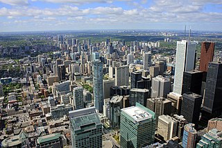
Downtown Toronto is the main central business district of Toronto, Ontario, Canada. Located entirely within the district of Old Toronto, it is approximately 16.6 square kilometres in area, bounded by Bloor Street to the northeast and Dupont Street to the northwest, Lake Ontario to the south, the Don Valley to the east, and Bathurst Street to the west. It is also the home of the municipal government of Toronto and the Government of Ontario.
Midtown is one of four central business districts outside the city's downtown core of Toronto, Ontario, Canada. Located in the north of Old Toronto, its borders are roughly defined by St. Clair Avenue to the south and Eglinton Avenue or Lawrence Avenue to the north, Bayview Avenue to the east and Dufferin Street to the west. The central neighbourhood of the area is Yonge–Eglinton.

Royal York Road, historically known as Church Street or New Church Street, is a north-south arterial road in Toronto, Ontario, Canada. It is a concession road, 5 concessions (10 km) west of Yonge Street, and runs through many residential neighbourhoods, most notably Mimico and the Kingsway. It is classified as a "minor arterial" road by the city of Toronto.

Bloor West Village is a residential neighbourhood and shopping district in Toronto, Ontario, Canada. Bordered on the south by Bloor Street, it encompasses all businesses along Bloor Street between South Kingsway and Ellis Park Road, consisting of more than 400 shops, restaurants and services, plus the residential neighbourhood to the north. The official City of Toronto name of the neighbourhood is Runneymede-Bloor West Village.

Jarvis Street is a north-south thoroughfare in downtown Toronto, Ontario, Canada, passing through some of the oldest developed areas in the city. Its alignment extends from Queens Quay East in the south to Bloor Street in the north. The segment south of Front Street is known as "Lower Jarvis Street" while the segment from Bloor Street to Mount Pleasant Road is known as "Ted Rogers Way".
43°43′35″N79°24′10″W / 43.7264°N 79.4028°W
| | This Toronto geographical article is a stub. You can help Wikipedia by expanding it. |