North York City Centre

Last updated

North York City Centre
Business district
Yonge St in North York 2022.jpg
North York City Centre, looking north along Yonge Street
North York Centre map.PNG
Municipality established1850 York Township
Changed municipality1922 North York from York Township
Changed municipality1998 Toronto from North York

North York City Centre is a central business district in Toronto, Ontario, Canada in the administrative district of North York. It is located along Yonge Street, between just south of Sheppard Avenue northward to Finch Avenue with its focus around Mel Lastman Square, a civic square, and spreads eastwards and westwards a few blocks, generally as far as Doris Avenue and Beecroft Road. The district is a high-density district of condominium and office towers with ground-floor commercial uses along the wide six lanes of Yonge Street.

Contents

The district was developed following the extension of the Yonge subway north to Finch Station. In the 1970s and 80s, the former City of North York encouraged the development of the area as a downtown, locating its civic offices, a public square, a central library, an arts centre and an aquatic centre on the west side of Yonge, about 600 metres north of Sheppard. The area's growth increased following the opening of North York Centre station at Mel Lastman Square and the Sheppard subway line. A shopping mall and cinemas were developed on the east side of Yonge Street across from Mel Lastman Square in the 1990s.

It is mostly located in the larger official neighbourhood of Willowdale, part of the former city of North York, and a former municipality (postal district) of its own, but also abuts the Lansing neighbourhood on the east side of Yonge Street near Sheppard Avenue. Following the amalgamation of North York with the rest of Toronto, North York City Centre became the largest of four central business districts in the new city outside Downtown Toronto. [1] All of the civic facilities were retained by the new City of Toronto.

History

In the 1800s, the forests in the area were cleared for farmland, around settlements made by Jacob Cummer and David Gibson alongside Yonge Street, which was the main road for travel from Toronto northward, and which served as Provincial Highway 11 from 1920 until 1998. The postal village of Willowdale was established within York County. North York Township was formed in 1923 from York Township. To the east and west, low-density single-family housing subdivisions were built beginning in the 1920s. As the area's population grew, the roadside became lined with commercial establishments, some being one-level highway arterial-type uses such as gas stations, with others being tightly knit two-storey buildings.

The post-World War II period saw the rapid growth of the suburbs of Toronto. To accommodate the growth, the township was changed into the Borough of North York after Metropolitan Toronto was split off from York County in 1953. The large expansion of Ontario Highway 401, known as the Toronto Bypass, just to the south connected the district to the rest of the Toronto area by freeway. The area was filled in by the 1960s with residential single-family subdivisions. By the 1960s, some high rise development was occurring, such as a Canadian Government Building at Yonge and Elmhurst Street and the twin-tower Sheppard Centre commercial and office complex at Yonge and Sheppard. The 1970s saw the extension of the Yonge–University line to Finch, connecting the area to downtown Toronto.

Following the opening of the subway extension, the area along Yonge Street, between Sheppard and Finch Avenues, was chosen by North York and Metropolitan Toronto to be developed into a central business district as the borough (which developed from a rural township and thus had no true historic downtown save for the original small Willowdale village where the city centre developed) was promoted to the status of city. An official plan by Metropolitan Toronto encouraged high-density commercial and residential developments in the area. The former City of North York chose to encourage the development of the area as a downtown by building a civic centre complex consisting of its civic offices, a public square, a central library, an arts centre, and an aquatic centre on the west side of Yonge, about 600 metres north of Sheppard at southwest corner of Park Home Avenue and Yonge.

Following the completion of the Scarborough RT, the City of North York convinced the Toronto Transit Commission to construct North York Centre station, an infill station on the Yonge–University line, to connect the new North York Civic Centre complex directly to the subway, which opened in 1987. On the east side of Yonge Street across from the Civic Centre, the Empress Walk mixed-use development, consisting of a shopping mall, cinema, and two condominium towers, was completed in 1997–2000. The streets sidewalks were widened and landscaped. The area's growth has continued steadily since then. The new Sheppard subway line opened in 2002, running along Sheppard Avenue from Don Mills Road in the east, to the expanded Sheppard-Yonge Station which crossroads with the Yonge-University line. The Sheppard Centre, originally built in the 1970s, had a cinema added in the late 1990s, then it was extensively renovated from 2016 to 2021. [2] [3]

A Toronto Police Service Interceptor Sedan races through the Sheppard-Yonge intersection in 2014.

Canada's deadliest vehicle-ramming attack occurred on April 23, 2018, when a rented van collided with numerous pedestrians, killing 10 and injuring 16 others on Yonge Street between Finch and Sheppard Avenues. [4] [5] One became quadriplegic and permanently required a ventilator at an assisted-living facility where she died in November 2021. [6]

Landmarks

The North York Civic Centre office complex and Mel Lastman Square, on the west side of Yonge Street, are central to the area. Across Yonge Street to the east is Empress Walk, a shopping mall that connects directly to the local subway station. North York Central Library, the Toronto Centre for the Arts, and the Toronto District School Board headquarters are all located adjacent to the square. The Joseph Shepard Building, a federal government office, is located on the west side of Yonge Street one block north of Sheppard Avenue. Further north and south along Yonge Street, office towers, condominium apartment towers and street-level shops line the street.

The Joseph Shepard Building, a federal government office. Edifice Joseph Shepard Building (Back).jpg
The Joseph Shepard Building, a federal government office.

Gibson House, a museum converted from a mid-19th-century house built by the Canadian politician David Gibson, a Scottish immigrant, land surveyor and participant of the Rebellion of 1837, is also located in this neighbourhood. Earl Haig Secondary School is located on Princess Avenue nearby.

The district is directly served by the North York Centre subway station, while Sheppard–Yonge and Finch subway stations are located at the southern and northern edges of the area, respectively. Finch station is a hub for GO Transit services for commuters from north of Toronto. The area is known for the high-level of traffic on the six lanes of Yonge Street, which connects to the Ontario Highway 401 south of Sheppard.

Related Research Articles

<span class="mw-page-title-main">Yonge Street</span> Historic road in Ontario, Canada

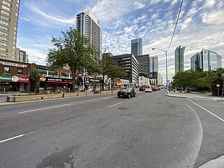
Yonge Street is a major arterial route in the Canadian province of Ontario connecting the shores of Lake Ontario in Toronto to Lake Simcoe, a gateway to the Upper Great Lakes. Ontario's first colonial administrator, John Graves Simcoe, named the street for his friend Sir George Yonge, an expert on ancient Roman roads.

<span class="mw-page-title-main">Koreatown, Toronto</span> Neighbourhood in Toronto, Ontario, Canada

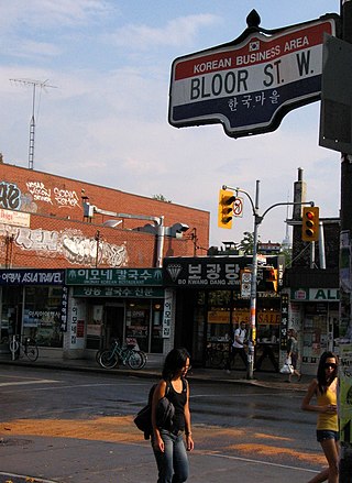
Koreatown is an ethnic enclave within Seaton Village, a neighbourhood of Toronto, Ontario, Canada. Located along Bloor Street between Christie and Bathurst Streets, the area is known for its Korean business and restaurants. The ethnic enclave developed during the 1970s, as the city experienced an influx of Korean immigrants settling in Toronto. Toronto has the largest single concentration of Koreans in Canada with 53,940 living in the city, according to the Canada 2016 Census.

<span class="mw-page-title-main">North York</span> District of Toronto, Ontario, Canada

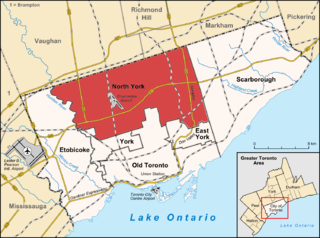
North York is a former township and city and is now one of the six administrative districts of Toronto, Ontario, Canada. It is located in the northern area of Toronto, centred around Yonge Street, north of Ontario Highway 401. It is bounded by York Region to the north at Steeles Avenue, on the west by the Humber River, on the east by Victoria Park Avenue. Its southern boundary corresponds to the northern boundaries of the former municipalities of Toronto: York, Old Toronto and East York. As of the 2016 Census, the district has a population of 644,685.

<span class="mw-page-title-main">Line 4 Sheppard</span> Subway line in Toronto, Ontario, Canada

Line 4 Sheppard is the newest and shortest subway line of the Toronto subway system, operated by the Toronto Transit Commission (TTC). It opened on November 22, 2002, and has five stations along 5.5 kilometres (3.4 mi) of track, which is built without any open sections in the district of North York along Sheppard Avenue East between Yonge Street and Don Mills Road. All stations are wheelchair accessible and are decorated with unique public art.

<span class="mw-page-title-main">Line 1 Yonge–University</span> Subway line in Toronto, Ontario, Canada

Line 1 Yonge–University is a rapid transit line on the Toronto subway. It serves Toronto and the neighbouring city of Vaughan in Ontario, Canada. It is operated by the Toronto Transit Commission, has 38 stations and is 38.4 km (23.9 mi) in length, making it the longest line on the subway system. It opened as the "Yonge subway" in 1954 as Canada's first underground passenger rail line, and was extended multiple times between 1963 and 2017. Averaging over 670,000 riders per weekday, Line 1 is the busiest rapid transit line in Canada, and one of the busiest lines in North America.

<span class="mw-page-title-main">Willowdale, Toronto</span> Neighbourhood in Toronto, Ontario, Canada

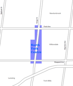
Willowdale is a neighbourhood in the city of Toronto, Ontario, Canada, located in the district of North York. It developed from three postal villages: Newtonbrook, Willowdale and Lansing.

<span class="mw-page-title-main">Sheppard–Yonge station</span> Toronto subway station

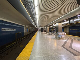
Sheppard–Yonge is an interchange station on Line 1 Yonge–University and Line 4 Sheppard of the Toronto subway. The station is located at the southern end of North York City Centre. It is the fourth-busiest station in the system, after Bloor–Yonge, St. George and Union, serving a combined total of approximately 134,076 people per day in 2019.

<span class="mw-page-title-main">North York Centre station</span> Toronto subway station

North York Centre is a subway station on Line 1 Yonge–University of the Toronto subway system. The station is located under Yonge Street, where it is intersected by Park Home Avenue and Empress Avenue. The station, the system's first and only infill station, opened in 1987 to serve North York City Centre, a high density business district in the Willowdale neighbourhood. Wi-Fi service is available at this station.

<span class="mw-page-title-main">Finch station</span> Toronto subway station

Finch is the northern terminus subway station of the eastern section of Line 1 Yonge–University in Toronto, Ontario, Canada. It is located under Yonge Street, north of Finch Avenue.

<span class="mw-page-title-main">North Yonge Railways</span>

The North Yonge Railways was a radial railway line operated by the Toronto Transportation Commission from 1930 to 1948 between Glen Echo (Toronto) and Richmond Hill. The line was created by reopening the southern portion of the TTC's Lake Simcoe radial line that had closed in 1930.

<span class="mw-page-title-main">North York Central Library</span>

North York Central Library is a Toronto Public Library branch located in North York City Centre, Toronto, Ontario, Canada. It is one of the two libraries in Toronto considered to be "Research and Reference Libraries", the other being the Toronto Reference Library in the city's downtown core. In contrast to the Toronto Reference Library, however, most of the items in the North York Central Library can be signed out.

<span class="mw-page-title-main">Willowdale (federal electoral district)</span> Federal electoral district in Ontario, Canada

Willowdale is a federal electoral district in Toronto, Ontario, Canada. It has been represented in the House of Commons of Canada since 1979. It is the riding with the biggest Korean community in Canada. As per the 2021 census, 9.9% of the population of Willowdale is Korean.

<span class="mw-page-title-main">North York Civic Centre</span>

The North York Civic Centre is a municipal government building in Toronto, Ontario, Canada. It opened in 1979 as the city hall of the former city of North York. It is located in North York City Centre.

<span class="mw-page-title-main">Mel Lastman Square</span>

Mel Lastman Square is a public square at North York Civic Centre in Toronto, Ontario, Canada. It is named after then North York mayor Mel Lastman. It was officially opened on June 16, 1989, by Norman Jewison and Mel Lastman's granddaughter Brie Lastman. The architects were J. Michael Kirkland.

<span class="mw-page-title-main">Empress Walk</span> Condominium and retail complex in Toronto, Ontario

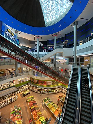
Empress Walk is a large Canadian condominium and retail complex in Toronto, Ontario, Canada. It is located at the intersection of Yonge Street and Empress Avenue in the North York Centre area of the North York district It was developed by Canadian-developers Menkes Developments Ltd. Phase 1 was completed in 1997 and Phase 2 was completed in 2000. It became an important retail complex in North York following its construction.

<span class="mw-page-title-main">York University Heights</span> Neighbourhood in Toronto, Ontario, Canada

York University Heights, also known as Northwood Park, is a neighbourhood in Toronto, Ontario, Canada. It is one of Toronto's northernmost neighbourhoods, located along the northern boundary of Steeles Avenue in the former city of North York. The neighbourhood is so named because it contains the main campus of York University. This area is most popular with immigrants of Italian and Chinese descent who have established communities in the area. It is located between Sheppard Avenue and Steeles Avenue east of Black Creek.

<span class="mw-page-title-main">Lansing, Toronto</span> Neighbourhood in Toronto, Ontario, Canada

Lansing is a neighbourhood in Toronto, Ontario, Canada. It originated as a minor settlement of a store, other services and a post office at the corner of Yonge Street and Sheppard Avenue and later got consolidated with Toronto as sprawling development took place. A larger area was designated as the postal village of Lansing. The City of Toronto labels it as Lansing-Westgate for neighbourhood planning purposes with the boundaries Yonge Street to the east, Highway 401 to the south, Bathurst Street to the west and Burnett Avenue to the north.

Network 2011 was a plan for transit expansion created in 1985 by the Toronto Transit Commission. It was centred on three proposed subway lines: the Downtown Relief Line, Eglinton West Line, and the Sheppard Line. Only a portion of the Sheppard Line was built. The Eglinton West and Downtown Relief Lines were cancelled; they were superseded by the Eglinton Crosstown light rail line and the Ontario Line respectively.

References

  1. Bow, James. "To the True End of Yonge Street VII: The Downtown that Mel Built". By James Bow.
  2. "Yonge Sheppard Centre Revitalization".
  3. "REMI Part of the REMI Network". www.reminetwork.com.
  4. Austen, Ian; Stack, Liam (April 23, 2018). "Toronto Van Plows Along Sidewalk, Killing 10 in 'Pure Carnage'". The New York Times . Retrieved April 23, 2018.
  5. "All 10 of those killed in Toronto van attack identified". CBC. Retrieved 4 May 2018.
  6. "'A huge loss': Yonge Street van attack victim Amaresh Tesfamariam missed 'every day'". Toronto.com . Toronto, Ontario, Canada. November 12, 2021. Retrieved November 12, 2021.

43°46′08″N79°24′47″W / 43.769°N 79.413°W / 43.769; -79.413