Smithfield, Toronto

Last updated

Smithfield
Neighbourhood
Mount Olive-Silverstone-Jamestown from Kipling.jpg
View of Smithfield from Kipling Avenue
Smithfield map.png
Mountolivesilverstonejamestown to locator.gif
Coordinates: 43°44′23″N79°34′49″W / 43.73972°N 79.58028°W / 43.73972; -79.58028
CountryCanada
Province Ontario
City Toronto
Established1870 Postal village 'Etobicoke'
Changed municipality1998 Toronto from Etobicoke
Government
   MP Kirsty Duncan (Etobicoke North)
   MPP Doug Ford (Etobicoke North)
   Councillor Vincent Crisanti (Ward 1 Etobicoke North)

Smithfield is a neighbourhood and former village in Toronto, Ontario, Canada. Some new residents of Toronto and new immigrants to Canada are attracted to this neighbourhood, mainly because there is a large amount of affordable public housing. It is named after the former village of Smithfield that was located at the intersection of Albion Road and Martin Grove Road. [1] The neighbourhood is located north of the west branch of the Humber River and west of Kipling Avenue.

Contents

Smithfield was established as a postal village in 1870 to serve the then-agricultural district. It started becoming urbanized after World War II as part of the development of the Rexdale district. Today, the area is fully urbanized. Originally part of Etobicoke Township, which later became the City of Etobicoke, it has been part of Toronto since 1998.

Primarily residential, the west and north of the neighbourhood are small industrial areas. For social purposes, the city identifies the neighbourhood as Mount Olive-Silverstone-Jamestown, named for three streets in the area. Mount Olive is the name given to the area north of Albion Road between Kipling and Martin Grove. Jamestown is the part of the community south of Albion between Kipling and Martin Grove. Silverstone covers the area west of Martin Grove and north of Finch. The northernmost section of the neighbourhood, above the hydro right of way, is known as South Steeles. The western projection of the area running along the south side of Finch is known as Woodbine Downs.

Character

Smithfield has experienced a large influx of citizens from Eastern Europe, Asia, the Caribbean, and the Middle East. The large expanses of rowhouse developments dating to the 1970s located on Mount Olive Drive just off Kipling Ave has been home to the first newcomers especially from Somalia and the West Indies. North Albion Collegiate Institute, opened in 1962 and located on Kipling and Mount Olive, has for years held showcases for the Asian and South East Asian Communities, attracting audiences from far and wide. Directly across the street, the St. Andrews School and Father Henry Carr Secondary School reflect the Catholic tradition and culture that is shared by many resident Filipinos, and Assyrians.

The Albion Centre (formerly known as "Shoppers World Albion") Is the main shopping mall in the area. Containing a variety of small boutiques and stores, the Albion Centre also contains such franchises as Pizza Pizza, Canadian Tire, and Shoppers Drug Mart. The Albion Cinemas have been operating since before 1970 and are still in operation. The cinemas, well known for their broadcasts of modern Bollywood/Indian/Asian films, have attracted many to this location.

Over the past few decades multiple attempts have been made to crackdown on gang violence in Rexdale. In May 2006, Toronto Police apprehended 106 members of the "Jamestown Crips" in the largest gang sweep in Toronto's history. In total, there were over 1,000 charges laid in the anti-gang offensive called Project XXX. [2] Sometimes known by the nickname Doomstown because of its reputation as a poor neighbourhood ridden with gang violence, the neighbourhood was the setting of the 2006 Canadian television movie Doomstown .

On June 04, 2015, more than 700 police officers participated in the series of raids, part of a multi-year investigation dubbed Project Pharaoh, which targeted a faction of the Mount Olive Crips known as "The Monstarz", who police alleged were involved in a series of deadly gunplay including 8 homicides & were known rivals to the nearby Jamestown Crips. [3]

Cityscape

Aerial view of Clairville and Smithfield in 2023 Clairville & Smithfield aerial view 2023.jpg
Aerial view of Clairville and Smithfield in 2023

Institutions

Etobicoke Hospital Etobicoke Hospital 2023.jpg
Etobicoke Hospital
The Albion branch of Toronto Public Library is located in Smithfield. Albion Library.jpg
The Albion branch of Toronto Public Library is located in Smithfield.

Parks

Place of worship

Education

West Humber Collegiate Institute is a secondary school located in Smithfield. West Humber Collegiate Institute.JPG
West Humber Collegiate Institute is a secondary school located in Smithfield.

Two public school boards operate elementary schools and secondary schools in the neighbourhood, the Toronto District School Board (TDSB), and the Toronto Catholic District School Board (TCDSB). Two secondary schools are located in the neighbourhood, West Humber Collegiate Institute (operated by TDSB), Father Henry Carr Catholic Secondary School (operated by TCDSB). Father Henry Carr Secondary School was relocated to Smithfield in 2007, taking the space of the former Marian Academy. [7]

Elementary schools in the neighbourhood include:

The North Campus of Humber College is located in Smithfield. Humber North Campus.jpg
The North Campus of Humber College is located in Smithfield.

The North Campus of Humber College, a post-secondary institution, is also in the neighbourhood. The University of Guelph's satellite campus, the University of Guelph-Humber, is on the same campus as Humber College's North Campus.

Transportation

Roads

One of the area's most high profile roads is John Garland Boulevard. The street was named for Nipissing MP and Minister of National Revenue John Richard 'Jack' Garland and fought to create housing development like Thistletown. Garland died of a heart attack in 1964 and the street was named in his honour in 1965. [8]

Related Research Articles

<span class="mw-page-title-main">Etobicoke</span> District of Toronto, Ontario, Canada

Etobicoke is an administrative district and former city within Toronto, Ontario, Canada. Comprising the city's west-end, Etobicoke is bordered on the south by Lake Ontario, on the east by the Humber River, on the west by Etobicoke Creek, the cities of Brampton, and Mississauga, the Toronto Pearson International Airport, and on the north by the city of Vaughan at Steeles Avenue West.

<span class="mw-page-title-main">New Toronto</span> Neighbourhood in Toronto, Ontario, Canada

New Toronto is a neighbourhood and former municipality in Toronto, Ontario, Canada. It is located in the south-west area of Toronto, along Lake Ontario. The Town of New Toronto was established in 1890, and was designed and planned as an industrial centre by a group of industrialists from Toronto who had visited Rochester, New York. New Toronto was originally a part of the Township of Etobicoke. It was an independent municipality from 1913 to 1967, being one of the former 'Lakeshore Municipalities' amalgamated into the Borough of Etobicoke, and eventually amalgamated into Toronto. The neighbourhood has retained the name.

<span class="mw-page-title-main">Rexdale</span> Neighbourhood in Toronto, Ontario, Canada

Rexdale is a neighbourhood of Toronto, Ontario, Canada, located north-west of the central core, in the district of Etobicoke. Rexdale defines an area of several official neighbourhoods north of Highway 401 and east of Highway 427. Rexdale was originally a post World War II residential development within Etobicoke, and today is applied to a general area from Malton and Toronto Pearson International Airport in the City of Mississauga to the west, Highway 401 to the south, Steeles Avenue to the north, and the Humber River to the east. It is centred on Rexdale Boulevard and Islington Avenue.

<span class="mw-page-title-main">Finch Avenue</span> Road in Toronto, Ontario, Canada

Finch Avenue is an arterial thoroughfare that travels east–west in Toronto, Ontario, Canada. The road continues west into the Regional Municipality of Peel as Regional Road 2 and east into the Regional Municipality of Durham as Regional Road 37.

<span class="mw-page-title-main">Thistletown</span> Neighbourhood in Toronto, Ontario, Canada

Thistletown is a culturally diverse neighbourhood in Toronto, Ontario, Canada. It consists of the area surrounding the intersection of Albion Road and Islington Avenue. The borders of Thistletown are generally delineated by the Humber River: the West Branch to the south, slightly beyond the river to the east, and to the William Osler Health Centre - Etobicoke General Hospital just above the river in the north. The western border is Kipling Avenue, though the part of the neighbourhood west of Islington is sometimes considered a separate area named Beaumonde Heights.

<span class="mw-page-title-main">Woodbridge, Ontario</span> Suburban district in York, Ontario, Canada

Woodbridge is a very large suburban community in Vaughan, Ontario, Canada, along the city's border with Toronto. It occupies the city's entire southwest quadrant, west of Highway 400, east of Highway 50, north of Steeles Avenue, and generally south of Major Mackenzie Drive. It was once an independent town before being amalgamated with nearby communities to form the city in 1971. Its traditional downtown core is the Woodbridge Avenue stretch between Islington Avenue and Kipling Avenue north of Highway 7.

<span class="mw-page-title-main">Kipling Avenue</span> Road in Toronto, Canada

Kipling Avenue is a street in the cities of Toronto and Vaughan in Ontario, Canada. It is a concession road, 6 concessions (12 km) west from Yonge Street, and is a major north–south arterial road. It consists of three separate sections, with total combined length of 26.4 km. (16.4 mi.).

<span class="mw-page-title-main">Richview, Toronto</span> Neighbourhood in Toronto, Ontario, Canada

Richview, formally known as Willowridge-Martingrove-Richview, is a neighbourhood in the city of Toronto, Ontario, Canada. It is bounded on the west by Highway 401 and on the north by the highway and by Dixon Road, Royal York Road on the east, and Eglinton Avenue West along the south. Richview was originally established as a postal village within the then-agricultural Etobicoke Township, which later became the suburb of Etobicoke.

<span class="mw-page-title-main">The Elms, Toronto</span> Neighbourhood in Toronto, Ontario, Canada

The Elms is a neighbourhood in Toronto, Ontario, Canada. It is bordered by the Humber River to the east, Islington Avenue to the west, Thistletown to the north, and Highway 401 to the south.

<span class="mw-page-title-main">Claireville, Toronto</span> Place in Ontario, Canada

Claireville is a neighbourhood and former hamlet in the city of Toronto, Ontario, Canada. It is located in the northwest corner of Toronto, in the former city of Etobicoke. Today Claireville is almost wholly industrial/commercial.

<span class="mw-page-title-main">Humber Valley Village</span> Neighbourhood in Toronto, Ontario, Canada

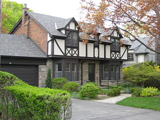
Humber Valley Village is a neighbourhood located in Toronto, Ontario, Canada. It is within the former suburb of Etobicoke and includes some of the most expensive real estate in the metropolitan west end. The boundaries are from Dundas Street on the south to Islington Avenue to the west, Eglinton Avenue to the north, and the Humber River in the east. The neighbourhood is in the political riding of Etobicoke Centre.

<span class="mw-page-title-main">North Albion Collegiate Institute</span> High school in Toronto, Ontario, Canada

North Albion Collegiate Institute is a high school in the Etobicoke area of the city of Toronto, Ontario, Canada. It is part of the Toronto District School Board. Prior to 1998, it was part of the Etobicoke Board of Education. Its motto is Virtus, Officium, Vertias.

<span class="mw-page-title-main">West Humber Collegiate Institute</span> High school in Toronto, Ontario, Canada

West Humber Collegiate Institute is a public high school in Toronto, Ontario, Canada. It is situated at the corner of Martin Grove Road and John Garland Blvd., just south of Finch Avenue West in the neighbourhood of Rexdale. Opened in 1966, the institute is owned and operated by the Toronto District School Board. Prior to 1998, it was overseen by the Etobicoke Board of Education.

<span class="mw-page-title-main">The Queensway–Humber Bay</span> Neighbourhood in Toronto, Ontario, Canada

The Queensway–Humber Bay, known officially as Stonegate–Queensway, is a neighbourhood in the southwest of Toronto, Ontario, Canada. It is located in the southeast area of the former City of Etobicoke.

<span class="mw-page-title-main">Line 6 Finch West</span> Under-construction light rail line in Toronto, Ontario, Canada

Line 6 Finch West, also known as the Finch West LRT, is a light rail line under construction in Toronto, Ontario, Canada, to be operated by the Toronto Transit Commission. The 10.3-kilometre (6.4 mi), 18-stop line is to extend from Finch West station on Line 1 Yonge–University to the North Campus of Humber College in Etobicoke. The line will operate in a dedicated above-ground right-of-way, much of it within Finch Avenue, segregated from street traffic. The line will use transit signal priority and standard gauge rather than the broad Toronto gauge. The line is forecast to carry about 14.6 million rides a year or 40,000 a day by 2031 and will replace the 36 Finch West bus route, which is one of the three busiest bus routes in Toronto. The line is expected to open within the first half of 2024, with an estimated cost of CA$2.5 billion. For budget purposes, the TTC made the assumption that Line 6 would open no earlier than September 2024.

<span class="mw-page-title-main">Princess Gardens</span> Neighbourhood in Toronto, Ontario, Canada

Princess Gardens is a neighbourhood in Toronto, Ontario, Canada. It is located in the western area of Toronto that was formerly the City of Etobicoke. Its boundaries are Eglinton Avenue to the north, Martin Grove to the west, Islington to the east, and Rathburn Road to the south. The southeastern part of this area is the separate neighbourhood of Thorncrest Village. The neighbourhood is divided into two areas: The portion east of Kipling Road is known as Princess Anne Manor, while the portion west of Kipling is Princess Margaret Gardens. They are named after Princess Anne, Princess Royal, and Princess Margaret, Countess of Snowdon, the daughter and sister of the late Queen Elizabeth II respectively. Both Princesses visited the Gardens and opened up Princess Margaret Public School during its opening ceremony. The southwestern part of the neighbourhood is also sometimes known as Glen Agar. Princess Gardens has some of the highest income Canadians in the Greater Toronto Area according to a 2016 census, at an average of $222,218 per year.

<span class="mw-page-title-main">Father Henry Carr Catholic Secondary School</span> Catholic high school in Ontario, Canada

Father Henry Carr Catholic Secondary School is a Catholic high school in Toronto, Ontario, Canada. It is administered by the Toronto Catholic District School Board, formerly the Metropolitan Separate School Board. It is named after a Basilian father and founder of the Pontifical Institute of Medieval Studies, Henry Carr (1880–1963).

Humberwood is a neighbourhood in Toronto, Ontario, Canada. It is located north-west of the central core in the former suburb of Etobicoke within the larger neighbourhood of Rexdale. Humberwood is named after the Humber River, which flows along its northern edge. Humberwood is bound to the north by the Humber River western branch from Highway 427 east to Highway 27, Highway 27 south to Rexdale Boulevard, east on Rexdale Boulevard to Islington Avenue, south on Islington to Highway 401, and west along the 401 to Highway 427. It is the southern part of the official City of Toronto "West Humber-Clairville" neighbourhood.

<span class="mw-page-title-main">Monsignor Percy Johnson Catholic High School</span> School in Toronto, Ontario, Canada

Monsignor Percy Johnson Catholic Secondary School is a Roman Catholic high school in the city of Toronto, Ontario, Canada part of the Toronto Catholic District School Board. It is located in the neighbourhood of Rexdale, in the former suburb of Etobicoke.

References

  1. Etobicoke Remembered by R. Given
  2. Police Display Weapons Seized In Gang Raids Archived 2007-01-27 at the Wayback Machine
  3. "Mount Olive Crips - Rap Dictionary". www.rapdict.org. Retrieved 2023-08-02.
  4. "Toronto Public Library > Hours & Locations > Branches A-Z > Albion District Library". www.torontopubliclibrary.ca. Archived from the original on 2004-07-17.
  5. "The Albion Centre". Archived from the original on 2009-02-17. Retrieved 2009-07-09.
  6. "マニュアル作成ツールで質の高いマニュアルを作ろう|Manual Creation Tool".
  7. Royson, James. "Closing school dagger to heart of Rexdale." Toronto Star . December 12, 2001. News p. B01. Retrieved on August 27, 2013.
  8. "John Garland Boulevard".