Dovercourt Park

Last updated

Dovercourt Park
Neighbourhood
Dovercourt Park Aerial view 2022.jpg
Aerial view of Dovercourt Park in 2022
Dovercourt Park map.png
Toronto map.png
Red pog.svg
Location within Toronto
Coordinates: 43°39′54″N79°25′55″W / 43.665°N 79.432°W / 43.665; -79.432
CountryFlag of Canada (Pantone).svg  Canada
Province Flag of Ontario.svg  Ontario
City Toronto
Established1792 York County
Township1793 York Township
Annexed1910 Toronto
Government
  City Councillor Alejandra Bravo (Ward 9)
Dianne Saxe (Ward 11)
  Federal M.P. Julie Dzerowicz (Davenport)
  Provincial M.P.P. Marit Stiles (Davenport)
Area
  Total0.863 km2 (0.333 sq mi)
Population
 (2021) [1]
  Total7,679
  Density8,898/km2 (23,050/sq mi)

Dovercourt Park or Dovercourt Village [2] is a neighbourhood in Toronto, Ontario, Canada situated north of Bloor Street between Christie Street to the east, the CPR railway lines to the north, and Dufferin Street to the west.

Contents

History

Dovercourt from Dovercourt Road and Bloor Street (c. 1910). The village was annexed by Toronto in 1910. Postcard of a streetcar at the corner of Dovercourt and Bloor.jpg
Dovercourt from Dovercourt Road and Bloor Street (c. 1910). The village was annexed by Toronto in 1910.

The Village of Dovercourt, located north of Dupont, was founded in the 1870s. Its residents were originally poor immigrants from England living in dozens of one and two bedroom tar and paper shacks which initially resulted in the village being called a shantytown. The village was annexed by the old City of Toronto in 1910 along with the Earlscourt area. City services were extended to the neighbourhood helping stimulate its growth and development by 1923. [3] The name Dovercourt comes from the name of the home of the Denison estate, located west of Dundas and Ossington.

Character

The neighbourhood contains a mixture of land-uses. The main thoroughfare of Bloor Street consists almost exclusively of mixed-use residential and commercial buildings. The Bloorcourt Village BIA posts its streetlamp banners on Bloor between Dufferin and Montrose.

The buildings along Bloor Street are typically two or three stories tall, with retail commercial on the main floor, and offices or rental housing on the remainder. These converted residential structures are the oldest in the district and are often in poor repair. Pigeon infestation remains an issue for tenants. At Dovercourt Road, a large, high-rise apartment complex houses lower-middle-income tenants on the southwest corner.

Businesses on Dovercourt and Hallam, centred on the intersection of Dovercourt Road and Hallam Street have formed their own BIA, the 'Dovercourt Village'. The boundaries stretch from Dupont south to Shanley and east-west from Salem to Ossington Avenue.

The residential area north of Bloor Street is primarily single-family dwellings. Many of these structures have been converted into apartments, housing up to eight separate units. Side-streets increase in zoned density as they approach Bloor. Low and medium-rise apartments occupy the majority of these zones.

To the north, between Dupont and Davenport, is mainly post-industrial development. Limited manufacturing remains, although some warehouse and light automotive industries still exist. While the Canadian Pacific Railway operates a main line between the two thoroughfares, a large amount of former industrial space has been converted to loft condominia. Some single-family rowhouses and low-income rental space has also been created.

The Bloor-Gladstone branch of the Toronto Public Library, dating from 1912, is situated at Bloor and Gladstone Avenue, one block east of Dufferin Avenue. From 2006 to 2009 the library was closed for renovation. It reopened to the public on July 23, 2009. [4]

Demographics

Historical population
YearPop.±%
20068,497    
20118,119−4.4%
20168,089−0.4%
20217,679−5.1%

For city demographics purposes the area is amalgamated with neighbouring areas to form Dovercourt-Wallace Emerson-Junction It is an ethnically diverse area. A majority of residents are fluent in Portuguese, Italian and English. A large Ethiopian population is also present in the area. There are many shops along Bloor Street serving the Portuguese and Ethiopian communities.

In the 2006 Canadian census Dovercourt Park was covered by census tracts 0095.00 and 0096.00. According to that census, the neighbourhood has 8,497 residents, a 9.2% decrease from the 2001 census. Average income is $28,311, below the average for Toronto. The ten most common language native languages, after English, are:

  1. Portuguese - 13.1%
  2. Unspecified Chinese - 3.5%
  3. Spanish - 3.5%
  4. Italian - 3.4%
  5. Cantonese - 2.8%
  6. Greek - 1.5%
  7. Mandarin - 1.5%
  8. Vietnamese - 1.0%
  9. French - 0.8%
  10. Urdu - 0.7%

Income

Census Tract 0095.00 reported that the average income in 2006 was $27,597 and rose to $35,649 by 2011. Additionally, the neighbourhood reported that the median income in 2006 was $20,322 while in 2011 it was $27,597. This meant that 46% of the populations in 2006 were below the median income in Canada, which was $27,258 while, in 2011 that number dropped to 35%. [5]

Census Tract 0096.00 reported a median income of $22,838 in 2006 and $23,721 in 2011, representing an increase of $883. Furthermore, the average income was $28,766 in 2006 and $34,228 in 2011. Compared to the average income of Canada, which was $40,650, over 68% of the population fell below the national average. [6]

Visible minority population

For Census Tract 0096.00, Chinese people represented the largest visible minority group in 2006 and 2011. The second largest community in 2011 were Latin Americans who increased by a fifth in size. During the same period, the Filipino population almost tripled in size, which moved it from the fifth largest visible minority group to the third largest. South Asians previously represented the second largest visible minority group, but they decreased by one third, resulting in a drop to fourth place. Finally, Black people remained unchanged between both years. [6]

Education

Transportation

Located in Dovercourt Park, Ossington station is a stop on the Bloor-Danforth subway line. Ossington Station.jpg
Located in Dovercourt Park, Ossington station is a stop on the Bloor–Danforth subway line.

Ossington and Dufferin stations on the Bloor–Danforth line serve the neighbourhood. The Dufferin bus runs north-south from Dufferin station and the Ossington and Rogers Road bus lines run north from Ossington station.

See also

Related Research Articles

<span class="mw-page-title-main">The Annex</span> Neighbourhood in Toronto, Ontario, Canada

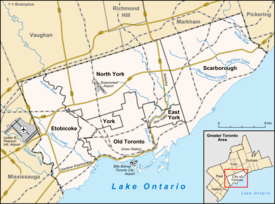
The Annex is a neighbourhood in Downtown Toronto, Ontario, Canada. The traditional boundaries of the neighbourhood are north to Dupont Street, south to Bloor Street, west to Bathurst Street and east to Avenue Road. The City of Toronto recognizes a broader neighbourhood definition that includes the adjacent Seaton Village and Yorkville areas.

<span class="mw-page-title-main">Parkdale, Toronto</span> Neighbourhood in Toronto, Ontario, Canada

Parkdale is a neighbourhood and former village in Toronto, Ontario, Canada, west of downtown. The neighbourhood is bounded on the west by Roncesvalles Avenue, on the north by the CP Rail line where it crosses Queen Street and Dundas Street. It is bounded on the east by Dufferin Street from Queen Street south, and on the south by Lake Ontario. The original village incorporated an area north of Queen Street, east of Roncesvalles from Fermanagh east to the main rail lines, today known as part of the Roncesvalles neighbourhood. The village area was roughly one square kilometre in area. The City of Toronto government extends the neighbourhood boundaries to the east, south of the CP Rail lines, east to Atlantic Avenue, as far south as the CN Rail lines north of Exhibition Place, the part south of King Street commonly known as the western half of Liberty Village neighbourhood.

<span class="mw-page-title-main">Trinity—Spadina</span> Former Canadian federal electoral district

Trinity—Spadina was a federal electoral district in Ontario, Canada, that was represented in the House of Commons of Canada from 1988 to 2015.

<span class="mw-page-title-main">Toronto—St. Paul's (federal electoral district)</span> Federal electoral district in Ontario, Canada

Toronto—St. Paul's is a federal electoral district in Toronto, Ontario, Canada, that has been represented in the House of Commons of Canada since 1935. Before the 2015 election, the riding was known as St. Paul's.

<span class="mw-page-title-main">St. James Town</span> Neighbourhood in Toronto, Ontario, Canada

St. James Town is a neighbourhood of Toronto, Ontario, Canada. It lies in the northeast corner of the downtown area. The neighbourhood covers the area bounded by Jarvis Street to the west, Bloor Street East to the north, Parliament Street to the east, and Wellesley Street East to the south.

<span class="mw-page-title-main">Dufferin station</span> Toronto subway station

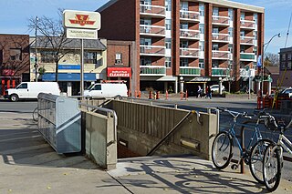
Dufferin is a subway station on Line 2 Bloor–Danforth of the Toronto subway in Toronto, Ontario, Canada. It is located at Dufferin Street just north of Bloor Street West. It opened in 1966 as part of the original segment of the subway line. Wi-Fi service is available at this station.

<span class="mw-page-title-main">Dufferin Street</span> Roadway in Ontario, Canada

Dufferin Street is a major north–south street in Toronto, Vaughan and King, Ontario, Canada. It is a concession road, two concessions (4 km) west of Yonge Street. The street starts at Exhibition Place, continues north to Toronto's northern boundary at Steeles Avenue with some discontinuities and continues into Vaughan, where it is designated York Regional Road 53. The street is named for Frederick Hamilton-Temple-Blackwood, 1st Marquess of Dufferin and Ava, who served as Governor General of Canada from 1872 to 1878. Prior to 1878 the street was labelled as Western City Limits or Sideline Road south off Bloor. In 2003 and 2007, it was voted as one of "Ontario's Worst 20 Roads" in the Ontario's Worst Roads poll organized by the Canadian Automobile Association.

<span class="mw-page-title-main">Seaton Village</span> Neighbourhood in Toronto, Ontario, Canada

Seaton Village is a neighbourhood and former village located west of Downtown Toronto in Toronto, Ontario, Canada. It is named after John Colborne, 1st Baron Seaton, Lieutenant-Governor of Upper Canada from 1828 to 1836. Bloor Street borders Seaton Village to the south, the Canadian Pacific Railway tracks to the north, Christie Street to the west, and Bathurst Street to the east. Officially, it is an enclave within The Annex neighbourhood, as defined by the City of Toronto. It is sometimes referred to as the West Annex. While Seaton Village shares several characteristics with the Annex, it is often perceived as a quieter, family-oriented neighbourhood. The Koreatown shopping district is at its southern border.

Amesbury or Brookhaven-Amesbury is a neighbourhood in Toronto, Ontario, Canada. The neighbourhood is located in northern Toronto in the former suburb of North York. It is part of federal and provincial electoral district York South—Weston, and Toronto electoral wards 11: York South—Weston (West) and 12: York South—Weston (East).

<span class="mw-page-title-main">Dufferin Grove</span> Neighbourhood in Toronto, Ontario, Canada

Dufferin Grove is a neighbourhood located in Toronto, Ontario, Canada, west of downtown. The neighbourhood is bordered by Bloor Street West to the north, Ossington Ave to the east, College Street to the south, and Dufferin Street to the west.

<span class="mw-page-title-main">Fairbank, Toronto</span> Neighbourhood in Toronto, Ontario, Canada

Fairbank is a neighbourhood in Toronto, Ontario, Canada. The area is centred on the intersection of Dufferin Street and Eglinton Avenue West. Fairbank includes the neighbourhoods of Briar Hill–Belgravia and Caledonia–Fairbank. The western border is the CNR lines. The northern and southern borders are the former borders of the City of York and the eastern border is Dufferin Street.

<span class="mw-page-title-main">Little Portugal, Toronto</span> Neighbourhood in Toronto, Ontario, Canada

Little Portugal is a neighbourhood and ethnic enclave in Toronto, Ontario, Canada. It is located west of downtown in the "Old" City of Toronto. It is bound on the west by Lansdowne Avenue, on the north by College Street, on the east by Ossington Avenue and on the south by the Go Transit and Union Pearson Express railway tracks. The area is mainly residential, with Portuguese businesses along Dundas Street West and College Street. The area west of Dufferin Street was a part of the former Town of Brockton. The area to the east of Dufferin and south of Dundas Street is also known as "Beaconsfield Village" dating back to the days of the sub-division of lots in the area around Beaconsfield Avenue.

Bloorcourt Village is a Business Improvement Area in Toronto, Ontario, Canada along Bloor Street east of Dufferin Street. It is located on the southern edge of the Dovercourt Park neighbourhood. This is west of downtown, and located within the former City of Toronto.

<span class="mw-page-title-main">Harbord Village</span> Neighbourhood in Toronto, Ontario, Canada

Harbord Village is a neighbourhood in Toronto, Ontario, Canada. It lies just to the west of the University of Toronto, with its most commonly accepted borders being Bloor Street on the north, Spadina Avenue on the east, College Street to the south, and Bathurst Street to the west. Areas west of Bathurst, as far as Ossington are also sometimes included, though they are not covered by the residents' association. The area was previously known as Sussex-Ulster, after two of the major east west streets in the area. In 2000 the residents' association decided to rename itself and the area Harbord Village, after the main street running through the middle of the community. The street's name origin is unclear but could be named for abolitionist Edward Harbord, 3rd Baron Suffield.

<span class="mw-page-title-main">Grange Park (neighbourhood)</span> Neighbourhood in Toronto, Ontario, Canada

Grange Park is a neighbourhood in downtown Toronto, Ontario, Canada. It is bounded on the west by Spadina Avenue, on the north by College Street, on the east by University Avenue and on the south by Queen Street West. It is within the 'Kensington-Chinatown' planning neighbourhood of the City of Toronto. Its name is derived from the Grange Park public park. The commercial businesses of Chinatown extend within this neighbourhood.

<span class="mw-page-title-main">Wallace Emerson</span> Neighbourhood in Toronto, Ontario, Canada

Wallace Emerson is a neighbourhood in Toronto, Ontario, Canada situated north of Bloor Street between Dufferin Street to the east, the CPR railway lines to the north and the CPR railway lines to the west.

<span class="mw-page-title-main">Ossington Avenue</span> Thoroughfare in Toronto, Ontario

Ossington Avenue is a main or arterial street in Toronto, Ontario, Canada, west of downtown. While the northern 3 kilometres (1.9 mi) of Ossington Avenue is residential, its southern terminus is popularly known as the Ossington Strip, an area popular for its dining, nightlife and shopping establishments.

<span class="mw-page-title-main">Junction Triangle</span> Neighbourhood in Toronto, Ontario, Canada

Junction Triangle is a neighbourhood in Toronto, Ontario, Canada. It is located in the city's west end, just west of Lansdowne Avenue. The area is a triangle surrounded on all three sides by railway lines: the CNR/CPR mainline to the west, Metrolinx GO Transit Barrie line to the east, and the CPR east-west railway lines to the north. Bloor Street cuts across the middle of the neighbourhood, Dupont Street runs close to the northern edge, and Dundas Street is close to the southern boundary. By some accounts, the recent residential developments of Davenport Village and Foundry Lofts, built on former factory lands north of the CP Rail line, west of Lansdowne, south of Davenport and east of the GO Transit Bradford/Newmarket/Barrie line, also belong in this neighbourhood.

<span class="mw-page-title-main">Trinity-Bellwoods</span> Neighbourhood in Toronto, Ontario, Canada

Trinity-Bellwoods is an inner city neighbourhood in Toronto, Ontario, Canada. It is bounded on the east by Bathurst Street, on the north by College Street, on the south by Queen Street West, and by Dovercourt Road on the west. It has a large Portuguese and Brazilian community, and many local Portuguese-Canadian businesses are located along Dundas Street West, continuing west into Little Portugal; this stretch further west along Dundas is known as Rua Açores.

<span class="mw-page-title-main">Harbord streetcar line</span> Former Toronto streetcar line (closed 1966)

The Harbord streetcar line was an east-west line within the Toronto streetcar system. The route was named after Harbord Street even though only a small portion of the route was along the namesake street. One distinct characteristic of the route was its zip-zag nature, making many 90-degree turns onto the various streets along its route. The route was retired in 1966 when the Toronto Transit Commission (TTC) opened the Bloor–Danforth subway line, the city's first east-west subway line.

References

  1. GeoSearch
  2. "Toronto is changing its map around to create 34 new neighbourhoods". blogTO.
  3. "Toronto Map - Toronto Neighbourhood Guide".
  4. "Bloor/Gladstone". Toronto Public Library. Retrieved 23 April 2018.
  5. Canada, Government of Canada, Statistics (11 December 2013). "2011 National Household Survey: Data tables – Household Income in 2010 (38), Household Type (9) and Selected Household Characteristics (18) for Private Households of Canada, Provinces, Territories, Census Metropolitan Areas and Census Agglomerations, 2011 National Household Survey". www12.statcan.gc.ca. Retrieved 23 April 2018.{{cite web}}: CS1 maint: multiple names: authors list (link)
  6. 1 2 Census/NHS 2011, Census 2006