External links
Places adjacent to Bloorcourt Village | |
|---|---|
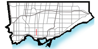
Bloorcourt Village is a Business Improvement Area in Toronto, Ontario, Canada along Bloor Street east of Dufferin Street. It is located on the southern edge of the Dovercourt Park neighbourhood. This is west of downtown, and located within the former City of Toronto.
The buildings along Bloor Street are typically two or three stories tall, with retail commercial on the main floor, and offices or rental housing on the remainder. These converted residential structures are the oldest in the district and some are in poor repair. Pigeon infestation remains an issue for tenants.
The Bloor-Gladstone branch of the Toronto Public Library, dating from 1912, is situated at Bloor and Gladstone Avenue, one block east of Dufferin Avenue. There are many shops along Bloor Street serving the Portuguese and Ethiopian communities of the Dufferin Grove and Dovercourt-Wallace neighbourhoods.
Ossington and Dufferin stations on the Bloor–Danforth line serve the area.
Places adjacent to Bloorcourt Village | |
|---|---|

Koreatown is an ethnic enclave in Toronto, Canada known for its Korean businesses. It is located along Bloor Street between Christie and Bathurst Streets in Seaton Village. The area developed during the 1970s due to an influx of Korean immigrants.

Trinity—Spadina was a federal electoral district in Ontario, Canada, that was represented in the House of Commons of Canada from 1988 to 2015.

Toronto—St. Paul's is a federal electoral district in Toronto, Ontario, Canada, that has been represented in the House of Commons of Canada since 1935. Its current MP is Carolyn Bennett. Prior to the 2015 election, the riding was known as St. Paul's.
Parkdale was a Canadian federal electoral district represented in the House of Commons of Canada from 1917 to 1979. It included the community of Parkdale in the western part of Toronto, Ontario. It was created in 1914 from Toronto West, and continued to exist until 1976 when most of it was merged into Parkdale—High Park with some sections into Trinity.

Dufferin is a subway station on Line 2 Bloor–Danforth of the Toronto subway in Toronto, Ontario, Canada. It is located at Dufferin Street just north of Bloor Street West. It opened in 1966 as part of the original segment of the subway line. Wi-Fi service is available at this station.

Dovercourt Park is a neighbourhood in Toronto, Ontario, Canada situated north of Bloor Street between Christie Street to the east, the CPR railway lines to the north, and Dufferin Street to the west.

Bloordale Village is a Business Improvement Area (BIA) that is located along Bloor Street from Lansdowne Avenue to Dufferin Street, west of downtown in Toronto, Ontario, Canada. It sits on the southern border of the Wallace Emerson neighbourhood and the northern border of the Brockton Village neighbourhood. The district is home to a mix of shopping, bars and vintage clothing, book, and video stores. There are also many, many furniture stores.

Dufferin Street is a major north–south street in Toronto, Vaughan and King, Ontario, Canada. It is a concession road, two concessions (4 km) west of Yonge Street. The street starts at the foot of Lake Ontario, continues north to Toronto's northern boundary at Steeles Avenue with some discontinuities and continues into Vaughan, where it becomes York Regional Road 53. The street is named for Frederick Hamilton-Temple-Blackwood, 1st Marquess of Dufferin and Ava, who served as Governor General of Canada from 1872 to 1878. In 2003 and 2007, it was voted as one of "Ontario's Worst 20 Roads" in the Ontario's Worst Roads poll organized by the Canadian Automobile Association.

Brockton Village is a former town, and now the name of a neighbourhood, in Toronto, Ontario, Canada. It comprises a section of the old Town of Brockton which was annexed by the City of Toronto in 1884.

Islington-City Centre West is a commercial and residential neighbourhood in Etobicoke, Toronto, Ontario, Canada. One of four central business districts outside Downtown Toronto, it is bounded by Rathburn Road to the north, Islington Avenue to the east, Bloor Street to the south, Mimico Creek to the west.

Glen Park is a neighbourhood in the city of Toronto, Ontario, Canada, located in the district of North York. It is bounded by Lawrence Avenue to the north, Bathurst Street to the east, a line south of Stayner Avenue to the south, and the CNR tracks to the west. Prior to the amalgamation of Metropolitan Toronto in 1998, it was part of the city of North York. It is also included as part of the larger official Yorkdale-Glen Park neighbourhood.

Old Mill is a neighbourhood of Toronto, Ontario, Canada on the banks of the Humber River. It is located north and west of the intersection of Bloor Street and Jane Street. The area takes its name from the old grist mill ruins on the west bank of the river, now converted into a hotel. The City of Toronto includes this neighbourhood in the official "Lambton Baby Point" neighbourhood which includes the Baby Point enclave and former Lambton village areas to the north.

Davenport is a provincial riding in Toronto, Ontario, Canada. It elects one member to the Legislative Assembly of Ontario.

Bloor West Village is a shopping district in Toronto, Ontario, Canada. Located along Bloor Street, it encompasses all businesses along Bloor Street between South Kingsway and Ellis Park Road, consisting of more than 400 shops, restaurants and services. The mix of stores include specialty clothing stores, book stores, restaurants and cafes. The businesses organized in 1970 into the first mandatory business improvement district, an idea that has spread to numerous other commercial streets in Toronto and to cities around the world.

Little Portugal (also known as Portugal Village is a neighbourhood and ethnic enclave in Toronto, Ontario, Canada. It is located west of downtown in the "Old" City of Toronto. It is bound on the west by Lansdowne Avenue, on the north by College Street, on the east by Bathurst Street and on the south by the Go Transit and Union Pearson Express railway tracks. The area is mainly residential, with Portuguese businesses along Dundas Street West and College Street. The area west of Dufferin Street was a part of the former Town of Brockton. The area to the east of Dufferin and south of Dundas Street is also known as "Beaconsfield Village" dating back to the days of the sub-division of lots in the area around Beaconsfield Avenue.

Lansdowne Avenue is an arterial road in Toronto, Ontario. It runs north–south and starts at Queen Street West and proceeds north to St. Clair Avenue West. Lansdowne Avenue is primarily a four-lane arterial road, with two lanes regularly used for motor vehicle parking.

Wallace Emerson is a neighbourhood in Toronto, Ontario, Canada situated north of Bloor Street between Dufferin Street to the east, the CPR railway lines to the north and the CPR railway lines to the west.
Ossington Avenue is a main or arterial street in Toronto, Ontario, Canada, west of downtown. Its southern terminus, popularly known as the Ossington Strip, a 560m segment constructed in 1816 to link two longer segments of a military road, was absorbed into the arterial after a century of independent existence. The consequence is a powerfully distinct identity for the Ossington Strip, a leading Toronto destination for pedestrianism, nightlife, dining, music, and shopping; in contrast, the remaining 3 km of Ossington Avenue is residential.
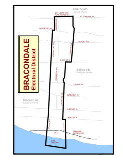
Bracondale was a provincial electoral district in Toronto, Ontario, Canada. It was represented in the Legislative Assembly of Ontario from 1926 to 1967. The constituency got its name from an old Toronto suburb called Bracondale, that was annexed by Toronto in 1909. Its most notable event was electing one of the first two women Members of the Provincial Parliament (MPP) to share the title "first-woman MPP" in 1943 when Rae Luckock was elected. In 1965, Bracondale's MPP, Joseph Gould, died in office sparking the final election held in the constituency. George Ben won the by-election, and became the constituency's last MPP. It was abolished for the 1967 Ontario provincial election, and redistributed into the Dovercourt and Bellwoods constituencies. As of 2012, the current electoral districts of Davenport, St. Paul's and Trinity–Spadina encompass this historic riding.