Newtonbrook

Last updated

Newtonbrook
Newtonbrook 2023.jpg
Aerial view of Newtonbrook from Newtonbrook Secondary School
Newtonbrook map.PNG
Newtownbrook and surroundings
Municipality established1850 York Township
Changed municipality1922 North York from York Township
Changed municipality1998 Toronto from North York

Newtonbrook is a neighbourhood in Toronto, Ontario, Canada. It is located in the area around Yonge Street and Finch Avenue in the district of North York between the east and west branches of the Don River. Officially, the area is divided into two neighbourhoods; Newtonbrook West and Newtonbrook East. [1]

Contents

History

The area was settled by Europeans in the early 19th century. Newtonbrook's early industries included saw and grist mills on the east and west branches of the Don River. The town's Newton Brook Wesleyan Church was named after Reverend Robert Newton.

In 1847, Lieutenant Colonel William S. Durie of The Queen's Own Rifles of Canada subdivided part of his Newtonbrook property. The resulting subdivision is now Drewry Avenue. [2]

Residences in Newtonbrook. Residential developments in Newtonbrook began during the 1950s. Newtonbrook houses.JPG
Residences in Newtonbrook. Residential developments in Newtonbrook began during the 1950s.

In the 1950s, Newtonbrook was subdivided for a massive residential development. Most of the town's landmarks were removed, except for the Newtonbrook Schoolhouse and the Newtonbrook General Store. Just one house from the original Drewry Avenue subdivision remains.

As of the end of 2006, Newtonbrook was the northernmost area of Toronto to be affected by the infill development (mainly along the Finch Ave. and Yonge St. corridors). Older detached and semi-detached houses from the 1950s were demolished (or converted to mixed residential-commercial use), with townhouse complexes built in their place. There is also an increasing number of new custom built homes in this neighbourhood. A new low-rise condo building was built on the northwest corner of Yonge and Drewry.

Demographics

View of Newtonbrook from Drewry Avenue and Yonge Street Newtonbrook Store.jpg
View of Newtonbrook from Drewry Avenue and Yonge Street

Newtonbrook contains a large community of Persian, Mandarin, Russian and Korean-speaking residents. English is the most spoken language of both Newtonbrook neighbourhoods, with Persian and Russian being the next most spoken languages of Newtonbrook West and Newtonbrook East, respectively. [3] [4]

The average income in the area is above the average for Toronto. Along with this, a majority of residents live in single detached or semi-detached houses in which they own.

Education

Newtonbrook Secondary School is one of three public secondary schools situated in Newtonbrook. Newtonbrook Secondary School.JPG
Newtonbrook Secondary School is one of three public secondary schools situated in Newtonbrook.

Three public school boards operate schools that offer primary and secondary education.

The Toronto District School Board (TDSB) is a secular public school board that operates two secondary schools in the neighbourhood, Newtonbrook Secondary School and Drewry Secondary School. Both schools are part of the North York Board of Education.

The Toronto Catholic District School Board (TCDSB) is a separate public school board that also operates an all-boys secondary school in Newtonbrook, Brebeuf College School. In addition to English-based public school boards, the Conseil scolaire catholique MonAvenir (CSCM) also operates a secondary school in Newtonbrook, École secondaire catholique Monseigneur-de-Charbonnel (formerly Lewis S. Beattie Secondary School). CSCM is a French-based separate public school board. The school and headquarters are leased from the TDSB. However before 1998, Brebeuf and Charbonnel were part of the Metropolitan Separate School Board when it was an English and French board at the time.

TCDSB and TDSB operate several schools in Newtonbrook that provide primary education. They include:

Recreation

Centerpoint Mall is a shopping mall located in the north of the neighbourhood. CenterpointMall.jpg
Centerpoint Mall is a shopping mall located in the north of the neighbourhood.

There are several shopping malls and plazas located within the neighbourhood, including Centerpoint Mall, on Steeles Avenue and Yonge Street, and Toronto Iranian Plaza. [5] The former Newtonbrook Plaza at Yonge and Cummer was demolished in 2018-2019 for the development of M2M Condos. [6] [7]

Newtonbrook is also home to several municipal parks, as well as the Finch Hydro Corridor. Parks in the neighbourhood are managed by the Toronto Parks, Forestry and Recreation Division.

Transportation

Public transportation in the neighbourhood is also serviced by the Toronto Transit Commission's (TTC) bus service. Newtonbrook is served by Finch subway station, which is the northern terminus of the Toronto Transit Commission's (TTC) Line 1 Yonge–University, located just south of the neighbourhood. In addition to TTC services, public transit services may also be accessed at Finch Bus Terminal, which provides access to GO Transit's commuter and regional buses. York Region Transit and Viva Rapid Transit may also be accessed from the terminal.

Notable people

It is the birthplace and hometown of Nobel Prize winner and Canadian Prime Minister Lester B. Pearson. Pearson was born at a manse in the intersection of Yonge Street and Hendon Avenue, now the site of the North American Life Centre. His father was the local Methodist minister and Lester was born in the parsonage.

See also

Related Research Articles

<span class="mw-page-title-main">York Mills</span> Neighbourhood in Toronto, Ontario, Canada

York Mills is a neighbourhood in Toronto, Ontario, Canada. It is centred around Yonge Street and York Mills Road located in the district of North York. In 2010, it encompassed the fourth and seventh most affluent postal codes in Canada. It is recognized as a millionaires' mile, alongside the other Toronto neighbourhoods of The Bridlepath, Forest Hill, and Rosedale.

<span class="mw-page-title-main">Malvern, Toronto</span> Neighbourhood in Toronto, Ontario, Canada

Malvern is a neighbourhood in the city of Toronto, Ontario, Canada, with a population of 44,315. It is located in the northeast corner of the city.

<span class="mw-page-title-main">Willowdale, Toronto</span> Neighbourhood in Toronto, Ontario, Canada

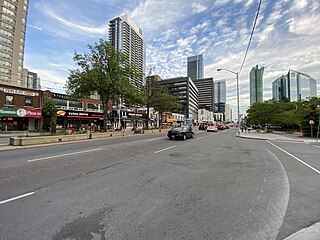
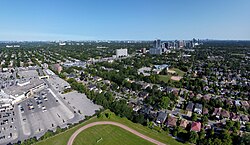
Willowdale is a neighbourhood in the city of Toronto, Ontario, Canada, located in the district of North York. It developed from three postal villages: Newtonbrook, Willowdale and Lansing.

<span class="mw-page-title-main">Lawrence Heights</span> Neighbourhood in Toronto, Ontario, Canada

Lawrence Heights is a neighbourhood in Toronto, Ontario, Canada. It is located north-west of central Toronto, in the district of North York. The neighbourhood is roughly bounded by Lawrence Avenue to the south, Yorkdale Road to the north, Varna Drive to the east and Dufferin Street to the west. It is part of the greater Yorkdale-Glen Park official Toronto neighbourhood.

<span class="mw-page-title-main">Henry Farm</span> Neighbourhood in Toronto, Ontario, Canada

Henry Farm is a neighbourhood in the City of Toronto, Ontario, Canada. It is located in the north central part of the city within the former city of North York.

<span class="mw-page-title-main">Richview, Toronto</span> Neighbourhood in Toronto, Ontario, Canada

Richview, formally known as Willowridge-Martingrove-Richview, is a neighbourhood in the city of Toronto, Ontario, Canada. It is bounded on the west by Highway 401 and on the north by the highway and by Dixon Road, Royal York Road on the east, and Eglinton Avenue West along the south. Richview was originally established as a postal village within the then-agricultural Etobicoke Township, which later became the suburb of Etobicoke.

<span class="mw-page-title-main">Humber Summit</span> Neighbourhood in Toronto, Ontario, Canada

Humber Summit is a neighbourhood in Toronto, Ontario, Canada. It is one of the northernmost neighbourhoods in Toronto, located in the North York district of the city. It is bounded by Steeles Avenue to the north, Highway 400 to the east, Finch Avenue to the south, and follows the Humber River to the west.

<span class="mw-page-title-main">Humbermede</span> Neighbourhood in Toronto, Ontario, Canada

Humbermede, often called Emery, is a neighbourhood of Toronto, Ontario, Canada. Humbermede, like many of the "Humber" neighbourhoods in the city, gets its name from the Humber River. It is bounded on the west by the Humber River, on the north by Finch Avenue West, on the east by the Highway 400 and on the south by Sheppard Avenue West.

<span class="mw-page-title-main">York University Heights</span> Neighbourhood in Toronto, Ontario, Canada

York University Heights, also known as Northwood Park, is a neighbourhood in Toronto, Ontario, Canada. It is one of Toronto's northernmost neighbourhoods, located along the northern boundary of Steeles Avenue in the former city of North York. The neighbourhood is so named because it contains the main campus of York University. This area is most popular with immigrants of Italian and Chinese descent who have established communities in the area. It is located between Sheppard Avenue and Steeles Avenue east of Black Creek.

<span class="mw-page-title-main">Yorkdale–Glen Park</span> Neighbourhood in Toronto, Ontario, Canada

Yorkdale–Glen Park is a neighbourhood in the city of Toronto, Ontario, Canada, located in the former suburb of North York. It is bounded by Highway 401 to the north, Allen Road to the east, a line south of Stayner Avenue to the south, and the CNR tracks to the west.

<span class="mw-page-title-main">Lawrence Manor</span> Neighbourhood in Toronto, Ontario, Canada

Lawrence Manor is a neighbourhood in the city of Toronto, Ontario, Canada. This neighbourhood is bounded by Bathurst Street on the east, Highway 401 to the north, the Allen to the west, and Lawrence Avenue to the south. The western side of the area borders along Bathurst Heights and the large public housing project.

<span class="mw-page-title-main">Clanton Park, Toronto</span> Neighbourhood in Toronto, Ontario, Canada

Clanton Park is a neighbourhood in Toronto, Ontario, Canada. Located in the district of North York, it is part of federal and provincial electoral district York Centre, and Toronto electoral wards 9: York Centre (West) and 10: York Centre (East). In 2016, it had a population of 16,472, a 12.7% rise from 2011.

<span class="mw-page-title-main">Westminster-Branson</span> Neighbourhood in Toronto, Ontario, Canada

Westminster-Branson is a neighbourhood in the city of Toronto, Ontario, Canada. It is in the northernmost part of the city within the area of North York.

<span class="mw-page-title-main">Pleasant View, Toronto</span> Neighbourhood in Toronto, Ontario, Canada

Pleasant View is a neighbourhood in the city of Toronto, Ontario, Canada that is located in the district of North York at the northern end of the city. It is bordered by Victoria Park to the East, Sheppard Avenue to the South, Highway 404 to the west and the Finch hydro corridor to the north. The neighbourhood is home to several high-rise apartment and condominium buildings, such as The Clippers.

<span class="mw-page-title-main">Don Valley Village</span> Neighbourhood in Toronto, Ontario, Canada

Don Valley Village is a neighbourhood in the city of Toronto, Ontario, Canada. It is located in the former suburb of North York. Located north of Highway 401 and bisected by Don Mills Road, it is bounded by Sheppard Avenue to the south, Leslie Street to the west, Finch Avenue to the north and Highway 404 to the east. Like the nearby Don River Valley, the neighbourhood has hill and dale topography.

<span class="mw-page-title-main">Bayview Woods-Steeles</span> Neighbourhood in Toronto, Ontario, Canada

Bayview Woods-Steeles is a neighbourhood located in the northern tip of the city of Toronto, Ontario, Canada in the district of North York. It is part of federal and provincial electoral district Don Valley North, and Toronto electoral ward 17: Don Valley North. In 2006, it had a population of 13,295. The area is divided by a series of ravines, and is often not considered a neighbourhood unto itself. Rather the sections are more often divided between the neighbouring areas of Hillcrest Village, Bayview Village, and Newtonbrook.

<span class="mw-page-title-main">Clairlea</span> Neighbourhood in Toronto, Ontario, Canada

Clairlea is a safe, quiet, middle to upper-middle income neighbourhood in Toronto, Ontario, Canada that features well treed streets and detached homes with large backyards. The neighbourhood is located in east Toronto just east of Victoria Park Avenue.

<span class="mw-page-title-main">Eglinton East</span> Neighbourhood in Toronto, Ontario, Canada

Eglinton East, historically known as Knob Hill, is a residential and commercial neighbourhood in Toronto, Ontario, Canada. It is bounded by Stansbury Crescent, Citadel Drive, and West Highland Creek to the north, Midland Avenue to the west, the CNR rail line, Brimley Road, and Eglinton Avenue to the south, and Bellamy Road North to the east.

<span class="mw-page-title-main">Morningside Heights, Toronto</span> Neighbourhood in Toronto, Ontario, Canada

Morningside Heights is a residential neighbourhood in Toronto, Ontario, Canada. It is located in the northeast corner of the city, in the district of Scarborough, just north of the neighbourhood of Malvern and west of Rouge Park and the Rouge. The subdivision, comprising approximately 750 acres (3.0 km2), was one of the last large tracts of undeveloped land within the City of Toronto, located between Finch Avenue East and Steeles Avenue East, from Tapscott Road to the Rouge River.

<span class="mw-page-title-main">Armour Heights</span> Neighbourhood in Toronto, Ontario, Canada

Armour Heights is a neighbourhood in Toronto, Ontario, Canada, in the district of North York. It is bounded by Wilson Avenue to the south, Bathurst Street to the west, and the west branch of the Don River to the north and east. Highway 401 cuts through the centre of the neighbourhood.

References

  1. "Neighbourhoods and Communities: Neighbourhood Profiles" . Retrieved August 29, 2021.
  2. "Heritage Toronto Mondays: Community of Newtonbrook" UrbanToronto 18 July 2011
  3. "Neighbourhoods and Communities: Neighbourhood Profiles: Newtonbrook West" (PDF). Retrieved August 29, 2021.
  4. "Neighbourhoods and Communities: Neighbourhood Profiles: Newtonbrook East" (PDF). Retrieved August 29, 2021.
  5. "Toronto Iranian Plaza - پلازای ایرانیان در تورنتو".
  6. "Five condo towers in works to replace North York's Newtonbrook Plaza". 30 October 2018.
  7. "Iconic Toronto strip mall about to be replaced by massive condo project".

43°47′N79°25′W / 43.783°N 79.417°W / 43.783; -79.417