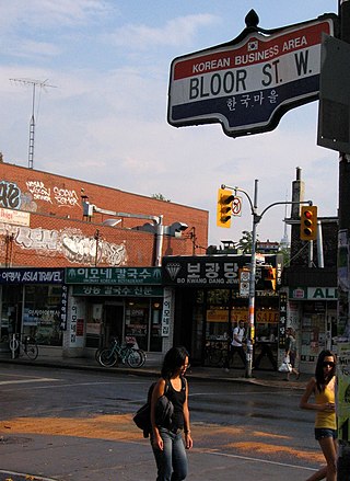
Koreatown is an ethnic enclave within Seaton Village, a neighbourhood of Toronto, Ontario, Canada. Located along Bloor Street between Christie and Bathurst Streets, the area is known for its Korean business and restaurants. The ethnic enclave developed during the 1970s, as the city experienced an influx of Korean immigrants settling in Toronto. Toronto has the largest single concentration of Koreans in Canada with 53,940 living in the city, according to the Canada 2016 Census.
Church and Wellesley is an LGBT-oriented enclave in Toronto, Ontario, Canada. It is roughly bounded by Gerrard Street to the south, Yonge Street to the west, Charles Street to the north, and Jarvis Street to the east, with the core commercial strip located along Church Street from Wellesley south to Alexander. Though some gay and lesbian oriented establishments can be found outside this area, the general boundaries of this village have been defined by the Gay Toronto Tourism Guild.

The Junction is a neighbourhood in Toronto, Ontario, Canada, that is near the West Toronto Diamond, a junction of four railway lines in the area. The neighbourhood was previously an independent city called West Toronto, that was also its own federal electoral district until amalgamating with the city of Toronto in 1909. The main intersection of the area is Dundas Street West and Keele Street. The Stockyards is the northeastern quadrant of the neighbourhood.

Roncesvalles is a neighbourhood in the city of Toronto, Ontario, Canada, centred on Roncesvalles Avenue, a north–south street leading from the intersection of King and Queen Streets to the south, north to Dundas Street West, a distance of roughly 1.5 kilometres. It is located east of High Park, north of Lake Ontario, in the Parkdale–High Park provincial and federal ridings and the municipal Ward 14. Its informal boundaries are High Park to the west, Bloor Street West to the north, Lake Ontario/Queen Street West to the south and Lansdowne Avenue/rail corridor to the east. Originally known as "Howard Park", most of this area was formerly within the boundaries of Parkdale and Brockton villages and was annexed into Toronto in the 1880s.

Yorkville is a neighbourhood and former village in Toronto, Ontario, Canada. It is roughly bounded by Bloor Street to the south, Davenport Road to the north, Yonge Street to the east and Avenue Road to the west, and it is part of The Annex neighbourhood. Established as a separate community in 1830, it was annexed into Toronto in 1883. Yorkville comprises residential areas, office space, and retail shopping.
Dovercourt Park or Dovercourt Village is a neighbourhood in Toronto, Ontario, Canada situated north of Bloor Street between Christie Street to the east, the CPR railway lines to the north, and Dufferin Street to the west.

Bloordale Village is a Business Improvement Area (BIA) located along Bloor Street from Dufferin Street to Lansdowne Avenue, west of downtown in Toronto, Ontario, Canada. It sits on the southern border of the Wallace Emerson neighbourhood and the northern border of the Brockton Village neighbourhood. The district is home to various and unique shops including restaurants, bars, vintage and thrift stores.

Bloor Street is a major east–west residential and commercial thoroughfare in Toronto, Ontario, Canada. Bloor Street runs from the Prince Edward Viaduct, which spans the Don River Valley, westward into Mississauga where it ends at Central Parkway. East of the viaduct, Danforth Avenue continues along the same right-of-way. The street, approximately 25 kilometres (16 mi) long, contains a significant cross-sample of Toronto's ethnic communities. It is also home to Toronto's famous shopping street, the Mink Mile.

Pape Village is a commercial district in Toronto, Ontario, Canada, located within the neighbourhood of Old East York. It is a mixed-use shopping street, consisting mainly of small-scale retail, restaurant and personal service uses.

Downtown Toronto is the main central business district of Toronto, Ontario, Canada. Located entirely within the district of Old Toronto, it is approximately 16.6 square kilometres in area, bounded by Bloor Street to the northeast and Dupont Street to the northwest, Lake Ontario to the south, the Don Valley to the east, and Bathurst Street to the west. It is also the home of the municipal government of Toronto and the Government of Ontario.

Islington-City Centre West is a commercial and residential neighbourhood in Toronto, Ontario, Canada. One of four central business districts outside Downtown Toronto, it is bounded by Rathburn Road to the north, Islington Avenue to the east, Bloor Street to the south, Mimico Creek to the west.

Oakridge is a neighbourhood in the city of Toronto, Canada, in the Scarborough district. The community neighbours Birch Cliff to the south, Danforth Village to the east and Cliffside to the west edging onto the Scarborough Bluffs. The neighbourhood is bordered by Victoria Park Avenue to the west, Massey Creek to the north, Warden Avenue to the east travelling south until Mack Avenue which then extends east again to the CNR rail line which forms the southern border.

High Park North, or often simply High Park, after the park, is a neighbourhood in Toronto, Ontario, Canada. It is bounded on the south by Bloor Street, on the west by Runnymede Road, on the north by Annette Street, Quebec Avenue and Humberside Avenue, and on the east by the GO Transit Weston Subdivision rail tracks. It is located in the Parkdale—High Park provincial and federal electoral districts. The area east of Keele Street is also known informally as the "West Bend" neighbourhood.

Runnymede Road is a street in the west end of Toronto, Canada. It runs from Morningside Avenue at its south end and ends at Henrietta Street, just north of St. Clair Ave. There is a small section continuing but ends in a Cul de sac. At its southern end, it begins as a narrow 2 lane road. It heads north to Bloor Street, where it widens to accommodate bikes lanes. At St. Clair, the bikes lanes stop, and it becomes a 2-way street north until Henrietta.
Bloorcourt Village is a Business Improvement Area in Toronto, Ontario, Canada along Bloor Street east of Dufferin Street. It is located on the southern edge of the Dovercourt Park neighbourhood. This is west of downtown, and located within the former City of Toronto.

Gerrard India Bazaar, also known as Little India, is a commercial South Asian ethnic enclave in the Leslieville neighbourhood of Toronto, Ontario, Canada. It is entirely situated along a portion of Gerrard Street (E), Toronto, between Greenwood Avenue and Coxwell Avenue, constituting the seventh largest South Asian marketplaces in North America.

East Danforth, also known as Danforth Village, is a neighbourhood in the east end of Toronto, Ontario, Canada. It is located on the eastern part of Danforth Avenue in the old city of Toronto. It stretches from the eastern edge of Greektown by Greenwood Avenue to the boundary of Scarborough at Victoria Park Avenue. The area is covered by two business improvement associations, Danforth Village and Danforth Mosaic. To the north of the neighbourhood is Old East York, once a separate municipality, but today closely integrated into the area. The southern border is the railway tracks, beyond which is Leslieville and the Upper Beaches. According to the 2006 census the area has a population of 14,629.

Wallace Emerson is a neighbourhood in Toronto, Ontario, Canada situated north of Bloor Street between Dufferin Street to the east, the CPR railway lines to the north and the CPR railway lines to the west.

Runnymede is a neighbourhood in Toronto, Ontario, Canada located north of Bloor Street West between Jane Street and Runnymede Road north to Dundas Street West. It is located directly north of the former village of Swansea and west of the High Park North neighbourhood. The immediate area around Bloor Street is commonly known as Bloor West Village after the shopping area along Bloor Street, whereas the area to the north is considered the Runnymede neighbourhood.


