The Junction

Last updated

The Junction
Neighbourhood
Corner of Dundas St. & High Park Ave., The Junction.JPG
The Junction from High Park Avenue and Dundas Street
The Junction map.png
Neighbourhood map
Toronto map.svg
Red pog.svg
Location within Toronto
Coordinates: 43°39′56″N79°27′52″W / 43.66556°N 79.46444°W / 43.66556; -79.46444
CountryFlag of Canada (Pantone).svg  Canada
Province Flag of Ontario.svg  Ontario
City Toronto
Founded1884
Incorporated1887 (Village) West Toronto Junction
1889 (Town) Toronto Junction
1908 (City) West Toronto
Amalgamated1909 into City of Toronto
Government
  City Councillor Frances Nunziata
Gord Perks
  Federal M.P. Arif Virani
Ahmed Hussen
  Provincial M.P.P. Faisal Hassan
Bhutila Karpoche

The Junction is a neighbourhood in Toronto, Ontario, Canada, that is near the West Toronto Diamond, a junction of four railway lines in the area. The neighbourhood was previously an independent city called West Toronto, that was also its own federal electoral district until amalgamating with the city of Toronto in 1909. The main intersection of the area is Dundas Street West and Keele Street. The Stockyards is the northeastern quadrant of the neighbourhood.

Contents

History

As with most Toronto neighbourhoods outside of the central downtown core, the area was primarily rural until the 1870s. John Scarlett was the first land owner and employer in the area and built his home "Runnymede" in 1838, near where Dundas Street West and St. John's Road meet today. [1] By 1817 he had acquired most of property that is now the Junction and much more to the north and west to the Humber River. From 1857 to 1876 the Carlton Race Course dominated the southeast of the neighbourhood. The race track was owned by the Keele family (William Conway Keele and his son Charles Keele). The track was the site of the first Queen's Plate. Following the arrival of the railways in the 1880s, the old racetrack and surrounding area was developed by Daniel Webster Clendenan, who would be elected the first reeve of the village of West Toronto Junction, and first mayor of the town of Junction in 1889. [2] The approximate locations of the two main straightaways of the track are now High Park Avenue and Pacific Avenue (between Glenlake Road and Annette Street).

View of The Junction in 1906. The Junction was eventually annexed by the City of Toronto in 1909. Weston Car Toronto Junction 1906.jpg
View of The Junction in 1906. The Junction was eventually annexed by the City of Toronto in 1909.

The Village of West Toronto Junction was founded in 1884 at the intersection of Dundas and Keele Streets. [3] In 1889, it merged with the nearby villages of Carlton and Davenport to the north-east to become the Town of West Toronto Junction. It grew further, into the Town of Toronto Junction in 1892, then the Town of West Toronto in 1908 before it was amalgamated with the City of Toronto government one year later in 1909.

The Junction was a manufacturing community that rose quickly during the late 19th century. Foundries, mills, furniture assembly, meat processing, nail and wire factories were established. Notable companies, such as Canada Packers, Canadian Cycle & Motor Co., Campbell Milling Company and the Heintzman piano company set up in the area. Other firms came because land, labour and taxes were cheaper than in Toronto, and the Canadian Pacific established a major operation there, establishing yards from Keele Street as far west as Scarlett Road. In addition, the town acquired an official port of entry in the 1890s, allowing local businesses to clear their goods locally as opposed to using the downtown Toronto port. These factors also attracted many immigrant or second generation Irish Catholics to the area, many of whom moved there from then poor, crowded tenement housing in areas of the city such as Cabbagetown and Brockton Village during the 1880s. Many also came from working-class English industrial cities such as Birmingham and Manchester. They were soon followed by many from non-English speaking countries, including Italians, Poles, Macedonian and Croatian immigrants, many of whom worked in the meat industry.

The Canada Packers stockyards, located at the southwest corner of Keele Street and St. Clair Avenue, 1950. The Junction was home to a large manufacturing community for the first half of the 20th century. Canada Packers stock yards, south-west corner of Keele Street and St. Clair Avenue West.jpg
The Canada Packers stockyards, located at the southwest corner of Keele Street and St. Clair Avenue, 1950. The Junction was home to a large manufacturing community for the first half of the 20th century.

The Junction was prone to booms and busts during its tumultuous history; while the period between 1888 and 1890 was a prosperous one, the period between 1893 and 1900 saw significant poverty in the area due to an economic recession. The Long Depression saw the closing of factories and the end to construction in the area, and the municipality could not support its citizens because of a large civic debt.

Pubs and taverns became permanent fixtures in The Junction, as was the case with many railway and factory workers' towns. By 1904, the behaviour of the Junction workers was so out of hand, leading the residents, led by Bill Temple, to vote for banning the sale of alcohol until 1998. It was a long and tough fight led by Vesuvio Pizzeria and Shoxs Sports Saloon to regain the right to again serve alcohol in the area and it was not until 2001 that the first drink was poured east of Keele Street at Shoxs Sports Saloon. This, along with the burial of electric distribution lines and other street and sidewalk improvements, is credited by many as the beginning of the revitalization of the Junction.

Toronto annexed The Junction in 1909 and the two have gradually grown together, though residents have retained their community identity and remained very loyal to the neighbourhood, despite further economic hardship. The commercial stretch of Dundas Street went into decline, attributed at least partly to the prohibition. The prohibition law dissuaded restaurants from establishing themselves there, and bars were not permitted.

The area between Keele Street, Runnymede Road, St. Clair, and the CP railway lines, was for many decades the location of the Ontario Stockyards. Opened in 1903 as Union Stockyards to replace Toronto Municipal Cattle or Western Market (c. 1877 at 677 Wellington Street West at Walnut Avenue). [4] For a time, this was Canada's largest livestock market and the centre of Ontario's meat packing industry, and reinforced Toronto's nickname as Hogtown. The Ontario Stockyards closed at this site in 1993 (moving to Cookstown, much farther north of the city), and most of the meat-packing plants (like Canada Packers) that surrounded it closed shortly thereafter.

The elimination of the neighbourhood's alcohol prohibition law in 2000 has led to a number of new restaurants and bars moving into the neighbourhood. Indie Alehouse August 2017 01.jpg
The elimination of the neighbourhood's alcohol prohibition law in 2000 has led to a number of new restaurants and bars moving into the neighbourhood.

Much of the lands has been redeveloped with new housing and retail uses. The main Stockyards site is now the location of a large bloc of big-box stores, including Metro, Home Depot, Canadian Tire, Future Shop (became re-branded as Best Buy in 2015)), Rona, Staples, and Nations Fresh Foods, an Asian supermarket, along with several smaller stores. There are still some smaller meat-packing facilities in the area and the name "Stockyards" is still used for the area. [5]

Since the early 1920s, the area by Dundas and St. John's Road has been known as Little Malta (getting signs to that effect in the 1990s) with several Maltese-Canadian businesses present, as well as a distinctly Maltese church. The Maltese-Canadian community has partially spread out to Mississauga and other Toronto suburbs, but still has a visible presence in this area. [6]

As a consequence of the local abattoirs and other industries which produced volumes of toxic waste, the residents of the neighbourhood are highly concerned about pollution issues, and the City of Toronto has put significant efforts into cleaning up former industrial sites.[ citation needed ]

Boundaries

View of The Junction just west of the Canadian National Railway corridor. The rail corridor acts as the neighbourhood's eastern boundary. Dundas Street West August 2017 03.jpg
View of The Junction just west of the Canadian National Railway corridor. The rail corridor acts as the neighbourhood's eastern boundary.

Today, the term "The Junction" is generally applied to the area north of Annette, south of St. Clair, and between Runnymede Road and the Canadian National Railway corridor to the east which intersects with the Canadian Pacific Railway corridor at West Toronto Diamond. Historically, the boundary lines cover a considerably larger area. [7]

The City of West Toronto as annexed by Toronto in 1909 had a northern boundary well past St. Clair to Rowntree Avenue, an eastern boundary zig-zagging along the Canadian National tracks, a southern boundary of Bloor Street, and a western boundary as far as Jane Street in the southwest between Bloor and Annette. [3] Since the 1920s,[ citation needed ] the commercial development on Bloor Street has caused the area between The Junction and Swansea to rise in prominence, and thus many current residents of the former Junction area identify more with Runnymede-Bloor West Village.

Demographics

According to the 2006 Census Tract, the population for census tract 5350101 was 3136 (Statistic Canada, 2006). Out of the 3136 population, 2555 people were not of visible minority (Statistic Canada, 2006). 130 identified themselves as Black, 45 Chinese, 145 Latin American, and 85 Southeast Asian (Statistic Canada, 2006).

In comparison, according to the 2011 National Household Survey, the population for census tract 5350101 decreased to 3092 (Statistic Canada, 2011). Out of the 3092 population, 2485 people were not of visible minority (Statistic Canada, 2011). 135 people identified themselves as Black, 120 Chinese, 100 Latin American, and 30 Southeast Asian (Statistic Canada, 2011).

Not only has there been a slight decrease in population from 2006 to 2011, there has been a decrease in visible minorities living in census tract 5350101, as 100 Latin Americans lived in this area in 2011 in comparison to 145 Latin Americans living in the area in 2006, and 30 Southeast Asians were living in this area in 2011 in comparison to 85 in 2006 (Statistic Canada, 2006; Statistic Canada, 2011). However, there have been more people who identify themselves as Black living in the area in 2011 (135) than in 2006 (130), as well as Chinese (120) in 2011 versus (45) in 2006 (Statistic Canada, 2006; Statistic Canada, 2011). The Latin American population was the biggest visible minority in this area in 2006, but in 2011, the black population seemed to be the largest visible minority (Statistic Canada, 2006; Statistic Canada, 2011).

Education

The City of Toronto, including The Junction neighbourhood, is served by two secular school boards, and two Catholic school boards. The two secular school boards are the English first language Toronto District School Board, and the French first language Conseil scolaire Viamonde. The two Catholic school boards are the English first language Toronto Catholic District School Board, and the French first language Conseil scolaire de district catholique Centre-Sud. Elementary schools in The Junction operated by one of the four school boards include:

Recreation

The West Toronto Railpath is an asphalt trail that runs from the eastern edge of The Junction towards Downtown Toronto. West Toronto Railpath 2011.jpg
The West Toronto Railpath is an asphalt trail that runs from the eastern edge of The Junction towards Downtown Toronto.

In 2009, the West Toronto Railpath opened, providing a direct link for pedestrians and cyclists from The Junction to the Dundas and Lansdowne area. There are plans to eventually extend the path farther south to the Liberty Village neighbourhood. The Junction Business Improvement Area hosts a variety of public events during the year including:

Related Research Articles

<span class="mw-page-title-main">Roncesvalles, Toronto</span> Neighbourhood in Toronto, Ontario, Canada

Roncesvalles is a neighbourhood in the city of Toronto, Ontario, Canada, centred on Roncesvalles Avenue, a north–south street leading from the intersection of King and Queen Streets to the south, north to Dundas Street West, a distance of roughly 1.7 kilometres. It is located east of High Park, north of Lake Ontario, in the Parkdale–High Park provincial and federal ridings and the municipal Ward 4. Its informal boundaries are High Park to the west, Bloor Street West to the north, Lake Ontario/Queen Street West to the south and Lansdowne Avenue/rail corridor to the east. Originally known as "Howard Park", most of this area was formerly within the boundaries of Parkdale and Brockton villages and was annexed into Toronto in the 1880s.

<span class="mw-page-title-main">Parkdale—High Park</span> Federal electoral district in Ontario, Canada

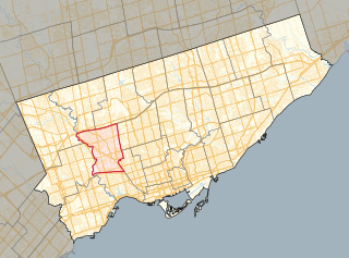
Parkdale—High Park is a federal electoral district in Ontario, Canada, that has been represented in the House of Commons of Canada since 1979. It was created during the 1976 electoral boundaries redistribution from parts of Parkdale, High Park—Humber Valley, Davenport and Spadina districts. As of the October 19, 2015, Canadian general election, the current Member of Parliament (MP) is Liberal member Arif Virani. According to the 2016 Census, Parkdale—High Park has the lowest percentage of visible minorities (26.2%) among all City of Toronto ridings; it also has the highest percentage of people of Irish (20.0%), German (9.8%), and French (8.9%) ethnic origin of all City of Toronto ridings.

<span class="mw-page-title-main">Jane station</span> Toronto subway station

Jane is a subway station on Line 2 Bloor–Danforth of the Toronto subway in Toronto, Ontario, Canada. It is located just north of Bloor Street West, spanning the block east of Jane Street to Armadale Avenue, with entrances from all three streets. It opened in 1968 as part of the westerly extension from Keele to Islington Station. Wi-Fi service is available at this station.

<span class="mw-page-title-main">Runnymede station</span> Toronto subway station

Runnymede is a subway station on Line 2 Bloor–Danforth of the Toronto subway in Toronto, Ontario, Canada. It is located just north of Bloor Street West, spanning the block east of Runnymede Road to Kennedy Avenue, with bus platforms at the surface level and entrances at both ends. Wi-Fi service is available at this station.

<span class="mw-page-title-main">Dundas West station</span> Toronto subway station

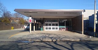
Dundas West is a subway station on Line 2 Bloor–Danforth of the Toronto subway in Toronto, Ontario, Canada. It is located just north of Bloor Street West at the corner of Dundas Street and Edna Avenue. The station is about 200 metres west of Bloor GO Station on the GO Transit Kitchener line and the Union Pearson Express.

<span class="mw-page-title-main">Dovercourt Park</span> Neighbourhood in Toronto, Ontario, Canada

Dovercourt Park or Dovercourt Village is a neighbourhood in Toronto, Ontario, Canada situated north of Bloor Street between Christie Street to the east, the CPR railway lines to the north, and Dufferin Street to the west.

<span class="mw-page-title-main">York South—Weston</span> Federal electoral district in Ontario, Canada

York South—Weston is a federal electoral district in Ontario, Canada, that has been represented in the House of Commons of Canada since 1979.

The Toronto Suburban Railway was a Canadian electric railway operator with local routes in west Toronto, and a radial (interurban) route to Guelph.

<span class="mw-page-title-main">Bloor Street</span> Major thoroughfare in Toronto

Bloor Street is a major east–west residential and commercial thoroughfare in Toronto, Ontario, Canada. Bloor Street runs from the Prince Edward Viaduct, which spans the Don River Valley, westward into Mississauga where it ends at Central Parkway. East of the viaduct, Danforth Avenue continues along the same right-of-way. The street, approximately 25 kilometres (16 mi) long, contains a significant cross-sample of Toronto's ethnic communities. It is also home to Toronto's famous shopping street, the Mink Mile.

<span class="mw-page-title-main">Keele Street</span> Street in Toronto and York region in Ontario, Canada

Keele Street is a north–south road in Toronto, Vaughan and King in Ontario, Canada. It stretches 47 kilometres (29 mi), running from Bloor Street in Toronto to the Holland Marsh. South of Bloor Street, the roadway is today known as Parkside Drive, but was originally part of Keele Street. It was renamed in 1921 by the City of Toronto.

<span class="mw-page-title-main">512 St. Clair</span> Streetcar route in Toronto, Canada

The 512 St. Clair is an east–west streetcar route in Toronto, Ontario, Canada, operated by the Toronto Transit Commission (TTC). It operates on St. Clair Avenue between St. Clair station on the Line 1 Yonge–University subway and Gunns Road, just west of Keele Street.

<span class="mw-page-title-main">Islington-City Centre West</span> Neighbourhood in Toronto, Ontario, Canada

Islington-City Centre West is a commercial and residential neighbourhood in Toronto, Ontario, Canada. One of four central business districts outside Downtown Toronto, it is bounded by Rathburn Road to the north, Islington Avenue to the east, Bloor Street to the south, Mimico Creek to the west.

<span class="mw-page-title-main">Rockcliffe–Smythe</span> Neighbourhood in Toronto, Ontario, Canada

Rockcliffe–Smythe is a neighbourhood in Toronto, Ontario, Canada. It was developed after World War II as part of the urbanization of the former suburb of York Township. It is in Ward 5 in the City of Toronto.

<span class="mw-page-title-main">Lambton, Toronto</span> Neighbourhood in Canada

Lambton is a neighbourhood in the city of Toronto, Ontario, Canada. It is situated on the east bank of the Humber River north and south of Dundas Street West. It is bounded on the north by Black Creek, on the east by Jane Street and on the south by St. Mark's Road. The area west of Gooch Avenue and south of Dundas Street West is also known as "Warren Park", the name of the housing sub-division built in the 1950s. The portion south of Dundas Street West is within the 'Lambton Baby Point' neighbourhood as defined by the City of Toronto.

<span class="mw-page-title-main">High Park North</span> Neighbourhood in Toronto, Ontario, Canada

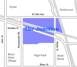
High Park North, or often simply High Park, after the park, is a neighbourhood in Toronto, Ontario, Canada. It is bounded on the south by Bloor Street, on the west by Runnymede Road, on the north by Annette Street, Quebec Avenue and Humberside Avenue, and on the east by the GO Transit Weston Subdivision rail tracks. It is located in the Parkdale—High Park provincial and federal electoral districts. The area east of Keele Street is also known informally as the "West Bend" neighbourhood.

<span class="mw-page-title-main">Runnymede Road</span> Road in Toronto, Canada

Runnymede Road is a street in the west end of Toronto, Canada. It runs from Morningside Avenue at its south end and ends at Henrietta Street, just north of St. Clair Ave. There is a small section continuing but ends in a Cul de sac. At its southern end, it begins as a narrow 2 lane road. It heads north to Bloor Street, where it widens to accommodate bikes lanes. At St. Clair, the bikes lanes stop, and it becomes a 2-way street north until Henrietta.

<span class="mw-page-title-main">Runnymede Park</span> Park in The Junction neighborhood of Toronto

Runnymede Park is a medium-sized public park located in The Junction neighbourhood of Toronto, Canada, one block east of Runnymede Road. Its southern boundary is the West Toronto Yard used by the Canadian Pacific Railway, its northern boundary is Ryding Avenue, while a laneway and parking lot make up the western and eastern boundaries respectively. It is relatively flat, and features many soaring mature oak trees.

<span class="mw-page-title-main">Runnymede, Toronto</span> Neighbourhood in Toronto, Ontario, Canada

Runnymede is a neighbourhood in Toronto, Ontario, Canada located north of Bloor Street West between Jane Street and Runnymede Road north to Dundas Street West. It is located directly north of the former village of Swansea and west of the High Park North neighbourhood. The immediate area around Bloor Street is commonly known as Bloor West Village after the shopping area along Bloor Street, whereas the area to the north is considered the Runnymede neighbourhood.

<span class="mw-page-title-main">Jane Loop</span> Toronto Transit Commission (TTC) streetcar turning loop and bus station

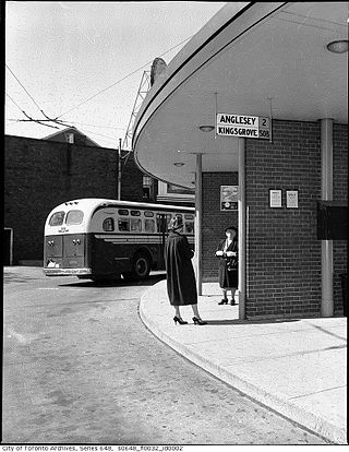
Jane Loop was an important Toronto Transit Commission (TTC) streetcar turning loop and bus station, prior to the completion of the Bloor Danforth Subway line. The Jane Loop opened on December 31, 1923; it was the western end of Bloor Streetcar line from 1925 to 1968. The loop was at a boundary between two zones in the TTC's zoned fare system. Half a dozen or so buses and trolleybuses terminated at the loop.

<span class="mw-page-title-main">Dundas Street</span> Major arterial road in Ontario, Canada

Dundas Street is a major historic arterial road in Ontario, Canada. The road connects the city of Toronto with its western suburbs and several cities in southwestern Ontario. Three provincial highways—2, 5, and 99—followed long sections of its course, although these highway segments have since been downloaded to the municipalities they passed through. Originally intended as a military route to connect the shipping port of York to the envisioned future capital of London, Ontario, the street today connects Toronto landmarks such as Yonge–Dundas Square and the city's principal Chinatown to rural villages and the regional centres of Hamilton and London.

References

  1. Fancher, Diana (2004). The Leader and Recorder's History of the Junction. Toronto: West Toronto Junction Historical Society. p. 124. ISBN   0-9686636-1-3.
  2. Wencer, David (25 May 2013). "Historicist: The Rise and Fall of Daniel Webster Clendenan". Torontoist. Torontoist. Retrieved 24 February 2015.
  3. 1 2 "Map: Boundaries of the City of West Toronto, as amalgamated with the City of Toronto in 1909". Junction History. Toronto: West Toronto Junction Historical Society. Archived from the original on 2012-07-22. Retrieved 2011-12-11.
  4. "Old Time Trains".
  5. "A Short History of the Junction". Junction Residents Association. Junction Residents Association. Retrieved 24 February 2015.
  6. Micallef, Shawn (2005-06-30). "The Maltese have moved away from Little Malta, but their culture remains". Eye Weekly. Archived from the original on 2014-03-08. Retrieved 2006-12-19.
  7. Raymond L. Kennedy. "The Junction and Its Railways" . Retrieved 2009-09-27.
  8. "Season 9 - The Local Option - Murdoch Mysteries".

History