Bedford Park, Toronto

Last updated

Bedford Park
Neighbourhood
Lawrence TTC looking east at Bedford Park entrance.JPG
Looking east from Bedford Park Avenue and Yonge Street
Bedford Park map.PNG
Location of Bedford Park
CountryFlag of Canada (Pantone).svg  Canada
Province Flag of Ontario.svg  Ontario
City Toronto

Bedford Park is a neighbourhood just outside the downtown core of Toronto. It borders Lawrence Park (to the southeast) which was ranked Canada's wealthiest neighbourhood in 2011. The City of Toronto's neighbourhood definitions places most of Bedford Park, including Bedford Park Avenue in the Lawrence Park North Planning Neighbourood and the remaining western and northern portions of Bedford Park within a larger neighbourhood, called Bedford Park-Nortown. The border of this larger area extend to Bathurst Street on the west, Highway 401 to the north, Hillhurst Boulevard (just north of Eglinton Avenue) to the south, and zigzags from northeast to southwest along Yonge Street and Avenue Road.

Contents

There are three census tracts created by Statistics Canada in Bedford Park: 0141.01, 0141.02, 0142.00.

History

The area began as a hamlet that was a popular stopover for farmers making their way to market in the city. The neighbourhood was likely named after the Bedford Park Hotel, which opened in 1873 at the southwest corner of Yonge Street and Fairlawn Avenue, just north of Lawrence Avenue. The corner now houses Sebastien patisserie.

Work on streetcar rails on Lawrence Avenue and Yonge Street, c. 1922. Streetcars service began in Bedford Park in 1890. YongeLawrence1922.jpg
Work on streetcar rails on Lawrence Avenue and Yonge Street, c. 1922. Streetcars service began in Bedford Park in 1890.

In 1890 Bedford Park was amalgamated with the hamlets of Davisville and Eglinton to the south, and incorporated as the Town of North Toronto. In the same year, the Metropolitan Street Railway of Toronto began service to the area, encouraging residential development.

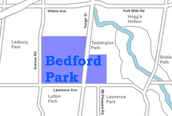
Bedford Park is bisected by Yonge Street, lying north of Lawrence Avenue and east of Avenue Road. The northern boundary is Brooke Avenue on the West side of Yonge, and Snowdon Avenue to the east of Yonge. The eastern boundary is Ronan Avenue. There is also a school north east of Yonge and Lawrence called Bedford Park Public School.

The original homes in the area were constructed between 1890 and 1940. Bedford Park was conceived as a middle class housing development on the northern boundary of the city, with mid-sized detached and semi-detached homes. The relocation of the Rosedale Golf Club in 1909 to the section of the Don Valley northeast of Bedford Park brought about development of the (more moneyed) bordering neighbourhoods of Lawrence Park and Teddington Park. This has skyrocketed the property values of Bedford Park homes.

Bedford Park's quiet streets, mature trees, good schools and parks, and proximity to Highway 401 and Lawrence subway station attract young professionals and their families to the neighbourhood. Many of the original homes still stand, with a number having undergone extensive renovations. A portion of the original homes in the neighbourhood have been torn down and replaced with larger, more modern homes.

Demographics

View of a residential street in Bedford Park. More than half of Bedford Park residents stated they were a third-generation Canadian or higher in the Canada 2011 Census. Yonge Blvd in Bedford-Nortown.jpg
View of a residential street in Bedford Park. More than half of Bedford Park residents stated they were a third-generation Canadian or higher in the Canada 2011 Census.

In 2011, there were 4599 people living in Bedford Park, 2260 male and 2375 female. 53% were third or higher generation Canadian, meaning the resident and both parents were born in Canada. 26.2% were second generation and 20.7% were first generation (immigrants).

In 2006, there were 4360 residents, 2105 male and 2220 female. 50% were third or higher generation. 28.8% were second generation and 21.2% were first generation.

The city is Census Tract 0141.02.

(Census/NHS 2011, Census 2006)

Income

Bedford Park has been a neighbourhood for middle class individuals. In 2006, the median individual income was $46,894 and in 2011 the median individual income increased to $58,658. The household median income in 2006 was $110,818 and in 2011 the median increased to $147,212.

(Census/NHS 2011, Census 2006)

Education

In Bedford Park, secular English-oriented public schools are operated by the Toronto District School Board. Publicly funded English-oriented Catholic schools are operated by the Toronto Catholic District School Board. In the City of Toronto, secular French-oriented public schools are provided by Conseil scolaire Viamonde , whereas French-oriented public Catholic schools are provided by Conseil scolaire catholique MonAvenir , although neither French school boards operate a school in Bedford Park. The following public schools are located in the Bedford Park:

43°43′48″N79°24′40″W / 43.730°N 79.411°W / 43.730; -79.411

Related Research Articles

<span class="mw-page-title-main">Bendale</span> Neighbourhood in Toronto, Ontario, Canada

Bendale, also called Cedarbrae and Midland Park, is a residential neighbourhood in the eastern part of Toronto, Ontario, Canada. It is located in the former suburb of Scarborough. It is centred on the intersection of Lawrence Avenue East and Brimley Road. Its boundaries, as defined by the City, are Midland Avenue from Lawrence, north to Highway 401, east to McCowan, south to Lawrence, east to West Highland Creek, south-west along West Highland Creek, then follow several side streets parallel to the Creek, north to Midland Avenue. The area north of Ellesmere is typically considered the Scarborough City Centre district, and is not considered in this neighbourhood article.

<span class="mw-page-title-main">North Toronto</span> Place in Ontario, Canada

North Toronto is a former town and informal district located in the northern part of the Old Toronto district in Toronto, Ontario, Canada. Currently occupying a geographically central location within the city of Toronto, the Town of North Toronto was incorporated in 1890, when much of the area was still farmland, and annexed by Toronto in 1912. The name is still used to refer to the area in general, although Yonge–Eglinton and Midtown Toronto are officially used.

<span class="mw-page-title-main">Lawrence Park, Toronto</span> Neighbourhood in Toronto, Ontario, Canada

Lawrence Park is a neighbourhood in Toronto, Ontario, Canada. It is bordered by Yonge Street to the west and Bayview Avenue to the east, and from Blythwood Ravine on the south to Lawrence Avenue on the north. Lawrence Park was one of Toronto's first planned garden suburbs. Begun in the early part of the 20th century, it did not fully develop until after the Second World War. It was ranked the wealthiest neighbourhood in all of Canada in 2011.

<span class="mw-page-title-main">York Mills</span> Neighbourhood in Toronto, Ontario, Canada

York Mills is a neighbourhood in Toronto, Ontario, Canada. It is centred around Yonge Street and York Mills Road located in the district of North York. In 2010, it encompassed the fourth and seventh most affluent postal codes in Canada. It is recognized as a millionaires' mile, alongside the other Toronto neighbourhoods of The Bridlepath, Forest Hill, and Rosedale.

<span class="mw-page-title-main">Willowdale, Toronto</span> Neighbourhood in Toronto, Ontario, Canada

Willowdale is a neighbourhood in the city of Toronto, Ontario, Canada, located in the district of North York. It developed from three postal villages: Newtonbrook, Willowdale and Lansing.

<span class="mw-page-title-main">Scarborough Village</span> Neighbourhood in Toronto, Ontario, Canada

Scarborough Village is a neighbourhood in Toronto, Ontario, Canada, located in the Scarborough district. It was one of the earliest settlements in the former township of Scarborough with the distinction of being the site of the township's first post office. Today, the neighbourhood is composed of private and public housing, apartment complexes, schools, a few condominiums, and strip mall plazas. The neighbourhood lies along the Scarborough Bluffs escarpment.

<span class="mw-page-title-main">Eglinton—Lawrence (federal electoral district)</span> Federal electoral district in Ontario, Canada

Eglinton—Lawrence is a federal electoral district in Ontario, Canada, that has been represented in the House of Commons of Canada since 1979.

<span class="mw-page-title-main">Richview, Toronto</span> Neighbourhood in Toronto, Ontario, Canada

Richview, formally known as Willowridge-Martingrove-Richview, is a neighbourhood in the city of Toronto, Ontario, Canada. It is bounded on the west by Highway 401 and on the north by the highway and by Dixon Road, Royal York Road on the east, and Eglinton Avenue West along the south. Richview was originally established as a postal village within the then-agricultural Etobicoke Township, which later became the suburb of Etobicoke.

Amesbury or Brookhaven-Amesbury is a neighbourhood in Toronto, Ontario, Canada. The neighbourhood is located in northern Toronto in the former suburb of North York. It is part of federal and provincial electoral district York South—Weston, and Toronto electoral wards 11: York South—Weston (West) and 12: York South—Weston (East).

<span class="mw-page-title-main">Yorkdale–Glen Park</span> Neighbourhood in Toronto, Ontario, Canada

Yorkdale–Glen Park is a neighbourhood in the city of Toronto, Ontario, Canada, located in the former suburb of North York. It is bounded by Highway 401 to the north, Allen Road to the east, a line south of Stayner Avenue to the south, and the CNR tracks to the west.

<span class="mw-page-title-main">Lawrence Manor</span> Neighbourhood in Toronto, Ontario, Canada

Lawrence Manor is a neighbourhood in the city of Toronto, Ontario, Canada. This neighbourhood is bounded by Bathurst Street on the east, Highway 401 to the north, the Allen to the west, and Lawrence Avenue to the south. The western side of the area borders along Bathurst Heights and the large public housing project.

<span class="mw-page-title-main">Clanton Park, Toronto</span> Neighbourhood in Toronto, Ontario, Canada

Clanton Park is a neighbourhood in Toronto, Ontario, Canada. Located in the district of North York, it is part of federal and provincial electoral district York Centre, and Toronto electoral wards 9: York Centre (West) and 10: York Centre (East). In 2016, it had a population of 16,472, a 12.7% rise from 2011.

<span class="mw-page-title-main">Lansing, Toronto</span> Neighbourhood in Toronto, Ontario, Canada

Lansing is a neighbourhood in Toronto, Ontario, Canada. It originated as a minor settlement of a store, other services and a post office at the corner of Yonge Street and Sheppard Avenue and later got consolidated with Toronto as sprawling development took place. A larger area was designated as the postal village of Lansing. The City of Toronto labels it as Lansing-Westgate for neighbourhood planning purposes with the boundaries Yonge Street to the east, Highway 401 to the south, Bathurst Street to the west and Burnett Avenue to the north.

<span class="mw-page-title-main">Victoria Village</span> Neighbourhood in Toronto, Ontario, Canada

For the settlement established by former slaves in Guyana known as Victoria Village see Victoria, Guyana

<span class="mw-page-title-main">Humewood–Cedarvale</span> Neighbourhood in Toronto, Ontario, Canada

Humewood–Cedarvale is an area of Toronto, Ontario, Canada, consisting of Humewood in the south, divided by Vaughan Road and Cedarvale Ravine. The neighbourhood is bordered by Bathurst Street on the east, Eglinton Avenue to the north, Arlington Avenue to the west, and St. Clair Avenue to the south. Humewood has also been known as "the Woods" because of its many streets that have names ending with "-wood", including Wychwood, Humewood, Cherrywood, Valewood, Maplewood, Wellwood, Kenwood, and Pinewood. The neighbourhood's main commercial areas are along St. Clair Ave. W., referred to as Hillcrest Village and along Eglinton Ave. W..

<span class="mw-page-title-main">Fairbank, Toronto</span> Neighbourhood in Toronto, Ontario, Canada

Fairbank is a neighbourhood in Toronto, Ontario, Canada. The area is centred on the intersection of Dufferin Street and Eglinton Avenue West. Fairbank includes the neighbourhoods of Briar Hill–Belgravia and Caledonia–Fairbank. The western border is the CNR lines. The northern and southern borders are the former borders of the City of York and the eastern border is Dufferin Street.

<span class="mw-page-title-main">Rockcliffe–Smythe</span> Neighbourhood in Toronto, Ontario, Canada

Rockcliffe–Smythe is a neighbourhood in Toronto, Ontario, Canada. It was developed after World War II as part of the urbanization of the former suburb of York Township. It is in Ward 5 in the City of Toronto.

<span class="mw-page-title-main">Clairlea</span> Neighbourhood in Toronto, Ontario, Canada

Clairlea is a safe, quiet, middle to upper-middle income neighbourhood in Toronto, Ontario, Canada that features well treed streets and detached homes with large backyards. The neighbourhood is located in east Toronto just east of Victoria Park Avenue.

<span class="mw-page-title-main">Lytton Park</span> Neighbourhood in Toronto, Ontario, Canada

Lytton Park is a neighbourhood in Toronto, Ontario, Canada. It is located in the "North Toronto" municipality, within the former city of Toronto. The neighbourhood is centered on 'Lytton Park'. Its boundaries include: Mona Drive to the west, Yonge Street to the east, Lawrence Avenue West to the north and Briar Hill Avenue to the south.

<span class="mw-page-title-main">Oakwood Village</span> Neighbourhood in Toronto, Ontario, Canada

Oakwood Village, formerly known as Oakwood–Vaughan, is a neighbourhood in Toronto, Ontario, Canada. Located in the former suburb of York, the neighbourhood is a Business Improvement Area (BIA); it has an annual arts festival and a public library built in 1997.