Lansing, Toronto

Last updated

Lansing
Neighbourhood
Construction near Sheppard and Yonge, 2014 06 28 (5).JPG - panoramio.jpg
View of Lansing from Sheppard Avenue and Yonge Street
Lansing map.PNG
CountryFlag of Canada (Pantone).svg  Canada
Province Flag of Ontario.svg  Ontario
City Toronto
Municipality established1850 York Township
Changed municipality1922 North York from York Township
Changed municipality1998 Toronto from North York

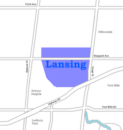
Lansing is a neighbourhood in Toronto, Ontario, Canada. It originated as a minor settlement of a store, other services and a post office at the corner of Yonge Street and Sheppard Avenue and later got consolidated with Toronto as sprawling development took place. A larger area was designated as the postal village of Lansing. The City of Toronto labels it as Lansing-Westgate for neighbourhood planning purposes with the boundaries Yonge Street to the east, Highway 401 to the south, Bathurst Street to the west and Burnett Avenue to the north.

Contents

History

Lansing has developed into a residential neighbourhood. Lansing, Toronto.JPG
Lansing has developed into a residential neighbourhood.

The postal village of Lansing was from Elmwood Avenue in the north to approximately the current location of Highway 401 in the south and Bathurst Street in the west to Bayview Avenue in the east with the actual post office located at the northwest corner of Yonge Street and Sheppard Avenue where a grocery store and other services were located. The postal village name was provided by Joseph Shepard's daughter Saida. The postal village of Lansing with those boundaries remained in existence until the post office at Lansing corner was closed upon the completion of a new post office to the north in Willowdale and the two villages were merged into a new postal village of Willowdale, within the Township of York. Over time, the area east of Yonge Street which was formerly part of the Lansing postal village was developed into residential suburbs and came to be considered part of Willowdale instead of Lansing.

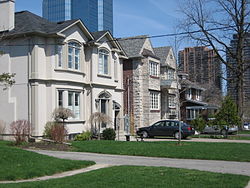
The Lansing area was developed into a residential neighbourhood of mostly single-family owned and occupied homes between 1910 and the 1950s. In the older portions nearest Yonge Street the homes are one- and two-storey pre-war houses while in the newest areas homes consist of modest one-and-a-half-storey postwar houses. Lansing is generally filled with two distinct types of households, the first being older couples, usually with adult children, living in post-war bungalows, and the second being younger wealthy families living in "rebuilds" in which wealthy families buy one or two bungalows, tear them down and build two-million-dollar houses.

Opened in 1948, York Cemetery is located to the north of the neighbourhood. Several notable individuals are interred there, including the Grand Duchess Olga Alexandrovna of Russia, and Tim Horton.

Demographics

According to the Canada 2006 Census: [1]

Education

Two public school boards operate elementary schools in Lansing. The separate Toronto Catholic District School Board (TCDSB) operates St. Edward Catholic School, whereas the secular Toronto District School Board (TDSB) operates Cameron Public School

Neither school board operates a secondary school in the neighbourhood, with secondary school students residing in Lansing attending institutions in adjacent neighbourhoods. The French first language public secular school board, Conseil scolaire Viamonde, and it separate counterpart, Conseil scolaire catholique MonAvenir also offer schooling to applicable residents of Lansing, although they do not operate a school in the neighbourhood. CSCM and CSV students attend schools situated in other neighbourhoods in Toronto.

Recreation

View of Earl Bales Park from Sheppard Avenue. Willowdale Ontario Canada Panorama.jpg
View of Earl Bales Park from Sheppard Avenue.

Lansing is home to several municipal parks, including Addington Greenbelt, Earl Bales Park, the Hinder Property, Grendolen Park, and Stuart Greenbelt. Most of these parks are situated near the Don Valley, which forms a part of the larger Toronto ravine system. Earl Bales Park also operates a ski hill during the winter. Municipal parks in Lansing are managed by the Toronto Parks, Forestry and Recreation Division. In addition to municipal parks, the division also manages a community centre in the neighbourhood, Earl Bales Community Centre.

The northeastern portion of the neighbourhood, along Yonge Street is also home to several restaurants retail outlets, forming a part of North York City Centre, the central business district for North York.

Transportation

Sidewalk entrance to Sheppard-Yonge station, a subway station in Lansing. Sheppard Entrance 02.jpg
Sidewalk entrance to Sheppard-Yonge station, a subway station in Lansing.

Several major roadways bound the neighbourhood to the east, and south. Yonge Street, is a major north-south thoroughfare, that bounds the neighbourhood to the east. Highway 401 is a major east-west controlled access highway that bounds the neighbourhood to the south. Other major roadways in the neighbourhood include the east-west Sheppard Avenue. Bathurst Street is located west of the neighbourhood.

Public transportation in Lansing is provided by the Toronto Transit Commission (TTC). TTC operates several bus routes, as well as the Toronto subway system. One subway station is situated in the neighbourhood, Sheppard–Yonge station. The station provides access to two subway lines, Line 1 Yonge–University, and Line 4 Sheppard. Regional commuter buses operated by GO Transit are also accessible from the station.

Related Research Articles

<span class="mw-page-title-main">Downsview</span> Neighbourhood in Toronto, Ontario, Canada

Downsview is a neighbourhood in the north end of Toronto, Ontario, Canada, located in the district of North York. The area takes its name from the Downs View farm established around 1842 near the present-day intersection of Keele Street and Wilson Avenue. It now extends beyond the intersection of Sheppard Avenue and Dufferin Street, though it is popularly seen as including the areas to the north right up to the Toronto city limit at Steeles Avenue. The area includes several large post-World War II subdivisions. Within the area is Downsview Airport, the former site of Canadian Forces Base Downsview, which has since been largely converted following the end of the Cold War into an urban park known as Downsview Park. The airport is still used as a manufacturing and testing facility for Bombardier Aerospace.

<span class="mw-page-title-main">North York City Centre</span> Business district

North York City Centre is a central business district in Toronto, Ontario, Canada in the administrative district of North York. It is located along Yonge Street, between just south of Sheppard Avenue northward to Finch Avenue with its focus around Mel Lastman Square, a civic square, and spreads eastwards and westwards a few blocks, generally as far as Doris Avenue and Beecroft Road. The district is a high-density district of condominium and office towers with ground-floor commercial uses along the wide six lanes of Yonge Street.

<span class="mw-page-title-main">Willowdale, Toronto</span> Neighbourhood in Toronto, Ontario, Canada

Willowdale is a neighbourhood in the city of Toronto, Ontario, Canada, located in the district of North York. It developed from three postal villages: Newtonbrook, Willowdale and Lansing.

<span class="mw-page-title-main">Lawrence Heights</span> Neighbourhood in Toronto, Ontario, Canada

Lawrence Heights is a neighbourhood in Toronto, Ontario, Canada. It is located north-west of central Toronto, in the district of North York. The neighbourhood is roughly bounded by Lawrence Avenue to the south, Yorkdale Road to the north, Varna Drive to the east and Dufferin Street to the west. It is part of the greater Yorkdale-Glen Park official Toronto neighbourhood.

<span class="mw-page-title-main">Henry Farm</span> Neighbourhood in Toronto, Ontario, Canada

Henry Farm is a neighbourhood in the City of Toronto, Ontario, Canada. It is located in the north central part of the city within the former city of North York.

<span class="mw-page-title-main">Bayview Village</span> Neighbourhood in Toronto, Ontario, Canada

Bayview Village is an neighbourhood in Toronto, Ontario, Canada. It is part of the federal Don Valley North riding and the provincial Don Valley North electoral district, and Toronto electoral Ward 17: Don Valley North. In 2006, it had a population of 15,370.

<span class="mw-page-title-main">North York Centre station</span> Toronto subway station

North York Centre is a subway station on Line 1 Yonge–University of the Toronto subway system. The station is located under Yonge Street, where it is intersected by Park Home Avenue and Empress Avenue. The station, the system's first and only infill station, opened in 1987 to serve North York City Centre, a high density business district in the Willowdale neighbourhood. Wi-Fi service is available at this station.

<span class="mw-page-title-main">Willowdale (electoral district)</span> Federal electoral district in Ontario, Canada

Willowdale is a federal electoral district in Toronto, Ontario, Canada. It has been represented in the House of Commons of Canada since 1979. It is the riding with the biggest Korean community in Canada. As per the 2021 census, 9.9% of the population of Willowdale is Korean.

<span class="mw-page-title-main">Sheppard Avenue</span> Road in Toronto, Ontario, Canada

Sheppard Avenue is an east–west principal arterial road in Toronto, Ontario, Canada. The street has two distinct branches near its eastern end, with the original route being a collector road leading to Pickering via a turnoff, and the main route following a later-built roadway which runs south to Kingston Road. To avoid name duplication, the Toronto portion of the northern branch was renamed Twyn Rivers Drive. The section of the street entirely in Toronto is (34.2 km) in length, while the Pickering section and Twyn Rivers Dr. is (5.4 km) long.

<span class="mw-page-title-main">Dufferin Street</span> Roadway in Ontario, Canada

Dufferin Street is a major north–south street in Toronto, Vaughan and King, Ontario, Canada. It is a concession road, two concessions (4 km) west of Yonge Street. The street starts at Exhibition Place, continues north to Toronto's northern boundary at Steeles Avenue with some discontinuities and continues into Vaughan, where it becomes York Regional Road 53. The street is named for Frederick Hamilton-Temple-Blackwood, 1st Marquess of Dufferin and Ava, who served as Governor General of Canada from 1872 to 1878. Prior to 1878 the street was labelled as Western City Limits or Sideline Road south off Bloor. In 2003 and 2007, it was voted as one of "Ontario's Worst 20 Roads" in the Ontario's Worst Roads poll organized by the Canadian Automobile Association.

<span class="mw-page-title-main">Richview, Toronto</span> Neighbourhood in Toronto, Ontario, Canada

Richview, formally known as Willowridge-Martingrove-Richview, is a neighbourhood in the city of Toronto, Ontario, Canada. It is bounded on the west by Highway 401 and on the north by the highway and by Dixon Road, Royal York Road on the east, and Eglinton Avenue West along the south. Richview was originally established as a postal village within the then-agricultural Etobicoke Township, which later became the suburb of Etobicoke.

<span class="mw-page-title-main">Bedford Park, Toronto</span> Neighbourhood in Toronto, Ontario, Canada

Bedford Park is a neighbourhood just outside the downtown core of Toronto. It borders Lawrence Park which was ranked Canada's wealthiest neighbourhood in 2011. The City of Toronto's neighbourhood definitions places most of Bedford Park, including Bedford Park Avenue in the Lawrence Park North Planning Neighbourood and the remaining western and northern portions of Bedford Park within a larger neighbourhood, called Bedford Park-Nortown. The border of this larger area extend to Bathurst Street on the west, Highway 401 to the north, Hillhurst Boulevard to the south, and zigzags from northeast to southwest along Yonge Street and Avenue Road.

<span class="mw-page-title-main">Pelmo Park-Humberlea</span> Neighbourhood in Toronto, Ontario, Canada

Pelmo Park-Humberlea is a neighbourhood in Toronto, Ontario, Canada. It is located north-west of the central core, in the former suburb of North York. Many of the neighbourhoods in this quadrant of the city can aptly be described as family neighbourhoods with access to parks, green space and a slower pace than found closer to downtown.

<span class="mw-page-title-main">York University Heights</span> Neighbourhood in Toronto, Ontario, Canada

York University Heights, also known as Northwood Park, is a neighbourhood in Toronto, Ontario, Canada. It is one of Toronto's northernmost neighbourhoods, located along the northern boundary of Steeles Avenue in the former city of North York. The neighbourhood is so named because it contains the main campus of York University. This area is most popular with immigrants of Italian and Chinese descent who have established communities in the area. It is located between Sheppard Avenue and Steeles Avenue east of Black Creek.

<span class="mw-page-title-main">Glen Park, Toronto</span> Neighbourhood in Toronto, Ontario, Canada

Glen Park is a neighbourhood in the city of Toronto, Ontario, Canada, located in the former suburb of North York. It is bounded by Lawrence Avenue to the north, Bathurst Street to the east, a line south of Stayner Avenue to the south, and the CNR tracks to the west. It is also included as part of the larger official Yorkdale-Glen Park neighbourhood.

<span class="mw-page-title-main">Lawrence Manor</span> Neighbourhood in Toronto, Ontario, Canada

Lawrence Manor is a neighbourhood in the city of Toronto, Ontario, Canada. This neighbourhood is bounded by Bathurst Street on the east, Highway 401 to the north, the Allen to the west, and Lawrence Avenue to the south. The western side of the area borders along Bathurst Heights and the large public housing project.

<span class="mw-page-title-main">Clanton Park, Toronto</span> Neighbourhood in Toronto, Ontario, Canada

Clanton Park is a neighbourhood in Toronto, Ontario, Canada. Located in the district of North York, it is part of federal and provincial electoral district York Centre, and Toronto electoral wards 9: York Centre (West) and 10: York Centre (East). In 2006, it had a population of 13,035.

<span class="mw-page-title-main">Pleasant View, Toronto</span> Neighbourhood in Toronto, Ontario, Canada

Pleasant View is a neighbourhood in the city of Toronto, Ontario, Canada that is located in the district of North York at the northern end of the city. It is bordered by Victoria Park to the East, Sheppard Avenue to the South, Highway 404 to the west and the Finch hydro corridor to the north. The neighbourhood is home to several high-rise apartment and condominium buildings, such as The Clippers.

<span class="mw-page-title-main">Don Valley Village</span> Neighbourhood in Toronto, Ontario, Canada

Don Valley Village is a neighbourhood in the city of Toronto, Ontario, Canada. It is located in the former suburb of North York. Located north of Highway 401 and bisected by Don Mills Road, it is bounded by Sheppard Avenue to the south, Leslie Street to the west, Finch Avenue to the north and Highway 404 to the east. Like the nearby Don River Valley, the neighbourhood has hill and dale topography.

<span class="mw-page-title-main">Armour Heights</span> Neighbourhood in Toronto, Ontario, Canada

Armour Heights is a neighbourhood in Toronto, Ontario, Canada, in the district of North York. It is bounded by Wilson Avenue to the south, Bathurst Street to the west, and the west branch of the Don River to the north and east. Highway 401 cuts through the centre of the neighbourhood.

References

  1. "2006 Census Tract (CT) Profiles".

Coordinates: 43°45′25″N79°25′01″W / 43.757°N 79.417°W / 43.757; -79.417