Princess Gardens

Last updated

Princess Gardens
Neighbourhood
Princess-Rosethorn aerial view pano 2025.jpg
Aerial view of Princess Gardens from Islington Ave at Poplar Heights Dr
Princess Gardens map.png
Coordinates: 43°40′13″N79°32′28″W / 43.67028°N 79.54111°W / 43.67028; -79.54111
Country Canada
Province Ontario
City Toronto
Established1946 (Subdivision) 'Thorncrest'
Changed Municipality1998 Toronto from Etobicoke
Government
   MP Yvan Baker (Etobicoke Centre)
   MPP Kinga Surma (Etobicoke Centre)
   Councillor Stephen Holyday (Ward 2)

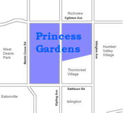
Princess Gardens is a neighbourhood in Toronto, Ontario, Canada. It is located in the western area of Toronto that was formerly the City of Etobicoke. Its boundaries are Eglinton Avenue to the north, Martin Grove to the west, Islington to the east, and Rathburn Road to the south. The southeastern part of this area is the separate neighbourhood of Thorncrest Village. The neighbourhood is divided into two areas: The portion east of Kipling Road is known as Princess Anne Manor, while the portion west of Kipling is Princess Margaret Gardens. They are named after Princess Anne, Princess Royal, and Princess Margaret, Countess of Snowdon, the daughter and sister of the late Queen Elizabeth II respectively. Both Princesses visited the Gardens and opened up Princess Margaret Public School during its opening ceremony. The southwestern part of the neighbourhood is also sometimes known as Glen Agar. Princess Gardens has some of the highest income Canadians in the Greater Toronto Area according to a 2016 census, at an average of $222,218 per year. [1]

Contents

Character

This is a post-war developed residential area. Its main street is Eglinton Avenue, a four-lane arterial road running east–west along the north of the neighbourhood. Residential subdivisions back onto Eglinton along this stretch. North-south are Martin Grove, Kipling and Islington Avenues, all four-lane arterial roads with detached homes on both sides. The density of the housing is very low, and road patterns are generally curved roads leading into cul-de-sacs to reduce traffic.

Largely built along an extension of the street 'The Kingsway' north of Dundas St, the area developed in a radically different manner than 'The Kingsway' neighbourhood to the south after the northern extension of the Kingsway was cut off from the south with the construction of a highway-style interchange at Dundas and Royal York. Like 'the Kingsway' neighbourhood to the south, many streets in Princess Gardens carry 'royal' names: The Kingsway, Prince George Dr, Princess Margaret Blvd, Princess Anne Cr.

Education

Richview Collegiate Institute is a secondary school located in Princess Gardens. Richview Collegiate Institute.jpg
Richview Collegiate Institute is a secondary school located in Princess Gardens.

The neighbourhood is home to schools operated by the public Toronto District School Board (TDSB), and the Toronto Catholic District School Board (TCDSB). TDSB is the only public school board that operates secondary schools in Princess Gardens, Martingrove Collegiate Institute and Richview Collegiate Institute.

TDSB and TCDSB elementary schools located in Princess Gardens include:

In addition to public schooling, the neighbourhood is also home to Phoenix Montessori School, a private Montessori school. [2]

Institutions

St. Luke's United Church is a place of worship located in the neighbourhood. St. Luke's United Church, Etobicoke.JPG
St. Luke's United Church is a place of worship located in the neighbourhood.

Churches

Notable current and former residents

See also

References

  1. "Do your neighbours make more than you? Search our map of income in the GTA". torontostar.com. November 9, 2017.
  2. "Home". phoenixmontessori.ca.