Summerhill, Toronto

Last updated

Summerhill
Neighbourhood
TorontoSummerhillEstate.jpg
Summer Hill house, c. 1900
Summerhill map.PNG
CountryFlag of Canada (Pantone).svg  Canada
Province Flag of Ontario.svg  Ontario
City Toronto

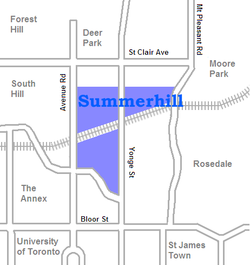
Summerhill is a neighbourhood in central Toronto, Ontario, Canada, located north of Downtown Toronto. [1]

Contents

History

It was named after Summer Hill house, built in 1842 by Canadian transportation magnate Charles Thompson. [2] Much of the area was once part of the original Thompson estate but was subdivided for development during the following decades. [3]

During the 1880s, the North Toronto railway station was established on Yonge Street, and the neighbourhood of Summerhill quickly developed around it. The railway station was rebuilt in 1916 in honour of a visit by the Prince of Wales (later King Edward VIII). The neighbourhood underwent very little growth after the railway station closed in 1931, but it was revitalized by the launch of the Summerhill subway station in 1954.

The railway station from 1916 still exists, and it currently serves as a LCBO outlet. The station, along with the still-operational Canadian Pacific Railway bridge, is a landmark of the neighbourhood. As part of the provincial government's "MoveOntario 2020" program, plans were being considered to return the building to its original use as a train station, serving a planned GO Transit Crosstown line.

Famous residents

The Honourable Chrystia Freeland, PC MP

Related Research Articles

<span class="mw-page-title-main">Yonge–Eglinton</span> Neighbourhood in Toronto, Ontario, Canada

Yonge–Eglinton is a neighbourhood in Toronto, Ontario, Canada, at the intersection of Yonge Street and Eglinton Avenue. It is central to the area of Midtown Toronto, one of four central business districts outside Downtown Toronto. The City of Toronto defines its boundaries as Briar Hill Avenue to the north, Yonge Street to the east, Frobisher Avenue and a line in that direction west to Elmsthorpe Avenue, then north to Eglinton Avenue, east to Avenue Road and north to Briar Hill.

<span class="mw-page-title-main">North Toronto</span> Place in Ontario, Canada

North Toronto is a former town and informal district located in the northern part of the Old Toronto district in Toronto, Ontario, Canada. Currently occupying a geographically central location within the city of Toronto, the Town of North Toronto was incorporated in 1890, when much of the area was still farmland, and annexed by Toronto in 1912. The name is still used to refer to the area in general, although Yonge–Eglinton and Midtown Toronto are officially used.

Summerhill or Summer Hill may refer to the following places:

<span class="mw-page-title-main">Spadina Avenue</span> Thoroughfare in Toronto, Ontario

Spadina Avenue is one of the most prominent streets in Toronto, Ontario, Canada. Running through the western section of downtown, the road has a very different character in different neighbourhoods.

<span class="mw-page-title-main">Lawrence Park, Toronto</span> Neighbourhood in Toronto, Ontario, Canada

Lawrence Park is a neighbourhood in Toronto, Ontario, Canada. It is bordered by Yonge Street to the west and Bayview Avenue to the east, and from Blythwood Ravine on the south to Lawrence Avenue on the north. Lawrence Park was one of Toronto's first planned garden suburbs. Begun in the early part of the 20th century, it did not fully develop until after the Second World War. It was ranked the wealthiest neighbourhood in all of Canada in 2011.

<span class="mw-page-title-main">Hoggs Hollow</span> Neighbourhood in Toronto, Ontario, Canada

Hoggs Hollow is a residential neighbourhood in Toronto, Ontario, Canada. It is located in the Don River Valley and centred on the intersection of Yonge Street, York Mills Road, and Wilson Avenue.

<span class="mw-page-title-main">Toronto—St. Paul's</span> Federal electoral district in Ontario, Canada

Toronto—St. Paul's is a federal electoral district in Toronto, Ontario, Canada, that has been represented in the House of Commons of Canada since 1935. Its current MP is Carolyn Bennett. Prior to the 2015 election, the riding was known as St. Paul's.

The Toronto Suburban Railway was a Canadian electric railway operator with local routes in west Toronto, and a radial (interurban) route to Guelph.

<span class="mw-page-title-main">Bathurst Street (Toronto)</span> Street in Toronto and York Region in Ontario, Canada

Bathurst Street is a main north–south thoroughfare in Toronto, Ontario, Canada. It begins at an intersection of the Queens Quay roadway, just north of the Lake Ontario shoreline. It continues north through Toronto to the Toronto boundary at Steeles Avenue. It is a four-lane thoroughfare throughout Toronto. The roadway continues north into York Region where it is known as York Regional Road 38.

<span class="mw-page-title-main">North Toronto station</span> Former railway station in Toronto

The North Toronto railway station is a former Canadian Pacific Railway (CPR) station in the northwest corner of the Rosedale neighbourhood of Toronto, Ontario, Canada. It is located on the east side of Yonge Street, adjacent to the neighbourhood of Summerhill, and a short distance south of the Summerhill subway station. The building is now home to a Liquor Control Board of Ontario (LCBO) liquor store.

<span class="mw-page-title-main">Islington-City Centre West</span> Neighbourhood in Toronto, Ontario, Canada

Islington-City Centre West is a commercial and residential neighbourhood in Toronto, Ontario, Canada. One of four central business districts outside Downtown Toronto, it is bounded by Rathburn Road to the north, Islington Avenue to the east, Bloor Street to the south, Mimico Creek to the west.

<span class="mw-page-title-main">York University Heights</span> Neighbourhood in Toronto, Ontario, Canada

York University Heights, also known as Northwood Park, is a neighbourhood in Toronto, Ontario, Canada. It is one of Toronto's northernmost neighbourhoods, located along the northern boundary of Steeles Avenue in the former city of North York. The neighbourhood is so named because it contains the main campus of York University. This area is most popular with immigrants of Italian and Chinese descent who have established communities in the area. It is located between Sheppard Avenue and Steeles Avenue east of Black Creek.

<span class="mw-page-title-main">Ionview</span> Neighbourhood in Toronto, Ontario, Canada

Ionview is a neighbourhood in Toronto, Ontario, Canada, in the district of Scarborough. It is bounded by Birchmount Road to the west, the hydro transmission corridor north of Ranstone Gardens to the north, the CNR railway to the east, and Eglinton Avenue East, Kennedy Road and the CNR railway to the south.

<span class="mw-page-title-main">Midtown, Toronto</span> Human settlement in Toronto, Ontario, Canada

Midtown is one of four central business districts outside the city's downtown core of Toronto, Ontario, Canada. Located in the north of Old Toronto, its borders are roughly defined by St. Clair Avenue to the south and Eglinton Avenue or Lawrence Avenue to the north, Bayview Avenue to the east and Dufferin Street to the west. The central neighbourhood of the area is Yonge–Eglinton.

<span class="mw-page-title-main">Wychwood Park</span> Neighbourhood in Toronto, Ontario, Canada

Wychwood Park is a neighbourhood enclave and private community in Toronto, Ontario, Canada. It is located west of Bathurst Street on the north side of Davenport Road, within the larger area of Bracondale Hill. It is considered part of the overall Wychwood official neighbourhood as designated by the City of Toronto.

<span class="mw-page-title-main">Toronto—St. Paul's (provincial electoral district)</span> Provincial electoral district in Ontario, Canada

Toronto—St. Paul's is a provincial electoral district in Ontario, Canada, that has been represented in the Legislative Assembly of Ontario since 1999. Before the 2018 election, it was known simply as St. Paul's.

<span class="mw-page-title-main">Lytton Park</span> Neighbourhood in Toronto, Ontario, Canada

Lytton Park is a neighbourhood in Toronto, Ontario, Canada. It is located in the "North Toronto" municipality, within the former city of Toronto. The neighbourhood is centered on 'Lytton Park'. Its boundaries include: Mona Drive to the west, Yonge Street to the east, Lawrence Avenue West to the north and Briar Hill Avenue to the south.

<span class="mw-page-title-main">South Hill, Toronto</span> Neighbourhood in Toronto, Ontario, Canada

South Hill is a neighbourhood in Toronto, Ontario, Canada. It is located north of downtown and covers the area west of Avenue Road, south of St. Clair Avenue, east of Spadina Road, and north of the Canadian Pacific railway tracks. The area is dominated by the steep hill of the Niagara escarpment. The Nordheimer Ravine also cuts through the area, which is surrounded by Sir Winston Churchill Park. This park covers the northwestern portion of South Hill.

<span class="mw-page-title-main">Railway Lands</span> Redevelopment district in Toronto, Ontario, Canada

Railway Lands is an area in Downtown Toronto, Ontario, Canada. Originally a large railway switching yard near the Toronto waterfront, including the CNR Spadina Roundhouse and the CPR John Roundhouse, it has since been redeveloped and today is home to mostly mixed-used development, including the CN Tower and the Rogers Centre. The lands were owned and maintained by the Canadian National Railway and later transferred to the federal crown corporation Canada Lands Company. The area is bounded by Front Street, Yonge Street, Gardiner Expressway and Bathurst Street. The western portion of the Railway Lands is now part of the CityPlace neighbourhood and the eastern portion is now called South Core.

Teddington Park is a neighbourhood in Toronto, Ontario, Canada. It is bordered by Yonge Street to the west and Bayview Avenue to the east, and from Snowden Road in the south to north of Glen Echo Road and Rosedale Golf Club. Development occurred in and around the 1930s, and was farmland before that time.

References

  1. Toronto Neighbourhood Guide – Summerhill
  2. "History of Summerhill". Archived from the original on 2020-06-07. Retrieved 2020-03-18.
  3. Summer Hill – Lost River Walks

43°40′59″N79°23′24″W / 43.683°N 79.390°W / 43.683; -79.390