Birch Cliff

Last updated

Birch Cliff
Neighbourhood
Birch Cliff.JPG
A group of houses in the Birch Cliff neighbourhood
Birch Cliff.PNG
Vicinity
Toronto map.png
Red pog.svg
Location within Toronto
Coordinates: 43°41′15″N79°16′10″W / 43.68750°N 79.26944°W / 43.68750; -79.26944
CountryFlag of Canada (Pantone).svg  Canada
ProvinceFlag of Ontario.svg  Ontario
City Toronto
Established municipality1850 Scarborough Township
Changed municipality1998 Toronto from Scarborough
Government
   MP Bill Blair (Scarborough Southwest)
   MPP Doly Begum (Scarborough Southwest)
   Councillor Vacant (Ward 20 Scarborough Southwest)

Birch Cliff is a neighbourhood in Toronto, Ontario, Canada. It is located in the eastern part of the city, part of the district of Scarborough running along the shore of Lake Ontario atop the western part of the Scarborough Bluffs. Birch Cliff has a large Irish population. About one-third of Birch Cliff residents are of Irish origin. [1] [2]

Contents

The area was first developed as the home of the Toronto Hunt Club in 1895 when the region was still mostly farms and woodland. Around the club, a number of cottages were erected and one of these was named "Birch Cliff." The Victorian dwelling (believed to exist today but significantly altered) was built on Springbank Avenue for John Stark, who named it after the birch trees along the edge of the nearby Scarborough Bluffs. [3] This name was also adopted by the local post office, and became the name for the neighbourhood.

The area can also be broken down to two smaller areas west of Warden Avenue to Victoria Park Avenue:

History

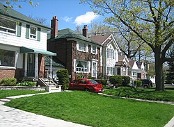
As the Beaches neighbourhood was built to the west, the region became the first part of Scarborough to be developed as a suburb to the city of Toronto during the 1920s. Unlike the rest of Scarborough, which was developed after the Second World War as automotive based suburbs, Birch Cliff began as a streetcar suburb when the then Toronto and Scarboro' Electric Railway, Light and Power Company began operations on Kingston Road, transitioned in 1921 as TTC streetcar line running along Kingston Road to Birchmount Road. As the most populated part of the borough, Scarborough's municipal council met in a building on Kingston Road beginning in 1922. Kingston Road became a busy shopping district.

The R. C. Harris Water Treatment Plant was completed in Birch Cliff in 1941. RC Harris Water Treatment Plant 2009.jpg
The R. C. Harris Water Treatment Plant was completed in Birch Cliff in 1941.

In 1932, construction of Toronto's R. C. Harris Water Treatment Plant began along Birch Cliff's waterfront. Completed in 1932, the water treatment plant was fashioned in an Art Deco style. The facility continues to function, and is operated by the City of Toronto government.

Streetcar service east of Victoria Park ended in 1954 and transitioned as suburban bus route [4] but during the post-World War II boom Kingston Road become a major thoroughfare for those living further east in the newer suburbs. Most of the shops closed. The area by the lake and the ravines remained a wealthy residential district, while further north is a more middle class portion of Scarborough. This area further north is sometimes referred to as Birch Cliff Heights. The westernmost portion of the neighbourhood, west of the Hunt Club, is known as Fallingbrook. It is closely linked to the Beaches.

A notable section of the neighbourhood is the former Birch Cliff Quarry. This area is a former quarry that was first used as a quarry by the Toronto Brick Company. It covers a large area south of the railroad tracks, north of Gerrard, and east of Victoria Park. From 1954 to 1960 the old quarry was used as a landfill. In 1960, the landfill was shut down and the site was sold to a development company. At the time the Scarborough Expressway was planned to parallel the rail line, and the site would have thus been next to a major interchange. It was thus zoned for high density apartment buildings with 1,450 units. The plan was a tower in a park scheme similar to what was built to the north at Crescent Town. The expense of cleaning up the former landfill delayed the project, and in any case, civic activism stopped the Scarborough Expressway. Contemporary new urbanism as promoted by Jane Jacobs also firmly rejects such suburban tower plans, but the area retains the original zoning and under Ontario Municipal Board the city is not allowed to revoke such a zoning. As of November 6, 2012, the Ontario Municipal Board has approved the "tower in the park" style development, to the remorse of many living in the community. [5]

Education

Birchmount Park Collegiate Institute is one of two public secondary school located in Birch Cliff. Birchmount Park CI.JPG
Birchmount Park Collegiate Institute is one of two public secondary school located in Birch Cliff.

Two public school boards operate schools in the neighbourhood.

The Toronto District School Board (TDSB) is a secular public school board, that operates one secondary school, Birchmount Park Collegiate Institute. In addition to secondary schools, TDSB also operates several elementary schools in Birch Cliff, including Birch Cliff Public School, Blantyre Public School, and Courcelette Public School.

The Toronto Catholic District School Board is a public separate school board that operates one elementary school in the neighbourhood, Immaculate Heart of Mary Catholic School, and one secondary school, Neil McNeil High School.

Recreation

Water feature in Rosetta McClain Gardens, a municipal park in Birch Cliff. Birch Cliff, Toronto, ON, Canada - panoramio (1).jpg
Water feature in Rosetta McClain Gardens, a municipal park in Birch Cliff.

The area is home to several municipal parks, including Birchmount Park, Crescentwood Park, Harrison Properties, and the Rosetta McClain Gardens. Parks in the neighbourhood are managed by the Toronto Parks, Forestry and Recreation Division. In addition to municipal parks, the city also owns Birchmount Stadium, a multi-purpose outdoor sports facility on Birchmount Road and Roy Halladay Field, a full sized baseball diamond located in Highview Park named after the former Toronto Blue Jays pitcher Roy Halladay. The Birch Cliff neighbourhood also features access to the Waterfront Trail [6] at the bottom of Warden Avenue.

Related Research Articles

<span class="mw-page-title-main">The Beaches, Toronto</span> Neighbourhood in Toronto, Ontario, Canada

The Beaches is a neighbourhood in Toronto, Ontario, Canada. It is so named because of its four beaches situated on Lake Ontario. It is located east of downtown within the "Old" City of Toronto. The approximate boundaries of the neighbourhood are from Victoria Park Avenue on the east to Kingston Road on the north, along Dundas Street to Coxwell Avenue on the west, south to Lake Ontario. The Beaches is part of the east-central district of Toronto.

<span class="mw-page-title-main">Port Union, Toronto</span> Neighbourhood in Toronto, Ontario, Canada

Port Union, also known as Centennial Scarborough is a neighbourhood in Toronto, Ontario, Canada. It is located in the south-east corner of Toronto, within the former suburb of Scarborough. The neighbourhood is bounded by Kingston Road to the north, Port Union Road to the east, the Lake Ontario shoreline to the south, and Highland Creek to the west.

<span class="mw-page-title-main">Cliffside, Toronto</span> Neighbourhood in Toronto, Ontario, Canada

Cliffside is a neighbourhood in Toronto, Ontario, Canada, located along the Scarborough Bluffs in the district of Scarborough. Its boundaries are Kennedy Road to the west, St. Clair Avenue East to the north, Brimley Road to the east, and the Bluffs on the lakeshore to the south.

<span class="mw-page-title-main">Wexford, Toronto</span> Neighbourhood in Toronto, Ontario, Canada

Wexford is a neighbourhood in Toronto, Ontario, Canada. It is located in the eastern part of the city, on the western end of the district of Scarborough, spanning Lawrence Avenue East between Victoria Park Avenue and Birchmount Road. There are many persons of Greek heritage in this neighbourhood. The Wexford Heights Business Improvement Area boasts 245 members and hosts an annual street festival on Lawrence.

<span class="mw-page-title-main">Scarborough Village</span> Neighbourhood in Toronto, Ontario, Canada

Scarborough Village is a neighbourhood in Toronto, Ontario, Canada, located in the Scarborough district. It was one of the earliest settlements in the former township of Scarborough with the distinction of being the site of the township's first post office. Today, the neighbourhood is composed of private and public housing, apartment complexes, schools, a few condominiums, and strip mall plazas. The neighbourhood lies along the Scarborough Bluffs escarpment.

<span class="mw-page-title-main">Kingston Road (Toronto)</span> Road in Toronto and Durham, Ontario, Canada

Kingston Road is a major arterial road in Toronto and Durham Region, Ontario. It the southernmost major (mainly) east-west road in the eastern portion of Toronto, specifically in the district of Scarborough, and runs east to Ajax in Durham. Until 1998, it formed a portion of Highway 2. The name of the street is derived from Kingston, Ontario as the road was the primary route used to travel from Toronto to the settlements east of it situated along the shores of Lake Ontario; in the west end of Kingston, the road was referred to as the York Road until at least 1908, and is today named Princess Street.

<span class="mw-page-title-main">Toronto and Scarboro' Electric Railway, Light and Power Company</span>

Toronto and Scarboro' Electric Railway, Light and Power Company was established in August 1892 to provide street railway service to the Upper Beaches district within the City of Toronto, Ontario and to the neighbouring Township of Scarborough. Except for two branches, the line ran as a radial along Kingston Road.

<span class="mw-page-title-main">West Rouge</span> Neighbourhood in Toronto, Ontario, Canada

West Rouge is a neighbourhood in Toronto, Ontario, Canada. It is located in the south-east corner of Toronto, within the former city of Scarborough. The community is roughly bounded by Lake Ontario to the south, the Rouge River and the Rouge National Urban Park to the east, Port Union Road to the west and Kingston Road to the north.

<span class="mw-page-title-main">Steeles, Toronto</span> Neighbourhood in Toronto, Ontario, Canada

Steeles is a suburban neighbourhood in Toronto, Ontario, Canada. Steeles is located in the north-eastern part of Toronto in the former suburb of Scarborough. To the north is bordered by Steeles Avenue East, to the east by Kennedy Road, to the south by a hydro-electric transmission line and to the west by Victoria Park Avenue.

<span class="mw-page-title-main">Tam O'Shanter-Sullivan</span> Neighbourhood in Toronto, Ontario, Canada

Tam O'Shanter-Sullivan is a neighbourhood in the east end of the city of Toronto, Ontario, Canada, in the district of Scarborough. The neighbourhood is bordered by Huntingwood Drive to the North, Kennedy Road to the East, Highway 401 to the South and Victoria Park to the West. The neighbourhood, which includes the Tam O'Shanter and Sullivan communities, takes its name from Tam O’Shanter Golf Course and O'Sullivan's Corners.

<span class="mw-page-title-main">Clairlea</span> Neighbourhood in Toronto, Ontario, Canada

Clairlea is a safe, quiet, middle to upper-middle income neighbourhood in Toronto, Ontario, Canada that features well treed streets and detached homes with large backyards. The neighbourhood is located in east Toronto just east of Victoria Park Avenue.

<span class="mw-page-title-main">Cliffcrest</span> Neighbourhood in Toronto, Ontario, Canada

Cliffcrest is a residential neighborhood in Toronto, Ontario, Canada. It is located along the shores of Lake Ontario in the district of Scarborough, bordered by Midland Avenue to the west, the Canadian National Railway to the north, and Bellamy Road to the east.

<span class="mw-page-title-main">Scarborough Junction</span> Neighbourhood in Toronto, Ontario, Canada

Scarborough Junction is a small neighbourhood in the Scarborough district of Toronto, Ontario, Canada. It is bordered by Birchmount Road, Brimley Road, Eglinton Avenue, and St. Clair Avenue. Scarbrough Junction has an approximated population of 20,000. The population consists of 1/4 Caucasian, 2/4 Asian and 1/4 other

<span class="mw-page-title-main">Dorset Park</span> Neighbourhood in Toronto, Ontario, Canada

Dorset Park is a neighbourhood in Toronto, Ontario, Canada. It is located in the western part of the district of Scarborough. The neighbourhood is bordered by Highway 401 to the north, Midland Avenue to the east, Lawrence Avenue to the south, and Birchmount Road to the west. Kennedy Road runs along the neighbourhood's centre north and south and Ellesmere Road runs along the centre east and west. The area south of Lawrence Avenue, north of the hydro corridor, is known as McGregor Park and is often included as part of Dorset Park.

<span class="mw-page-title-main">Woburn, Toronto</span> Neighbourhood in Toronto, Ontario, Canada

Woburn is a neighbourhood located in eastern Toronto, Ontario, Canada, in the former suburb of Scarborough. Woburn is bordered by Highway 401 to the north, Orton Park Road to the east, Lawrence Avenue to the south, and McCowan Road to the west.

<span class="mw-page-title-main">Upper Beaches</span> Neighbourhood in Toronto, Ontario, Canada

The Upper Beaches is a neighbourhood in Toronto, Ontario, Canada. It is directly north of the Beaches area. It stretches from Coxwell Avenue in the west to Victoria Park in the east. The southern border is Kingston Road, while the northern boundary is generally considered to be the Canadian National Railway tracks between Gerrard Street and Danforth Avenue. The western part of the area was originally called Norway, and the larger area was once part of the Town of East Toronto. The name "Upper Beaches" was first used by developers and real estate agents around the period of 2001 to 2003 for the selling of houses on redeveloped land in the area, and was used as a marketing tag to attract buyers. The area was never considered part of the Beaches neighbourhood but was close to it. The city's current name for this area is East End Danforth, though that is rarely used. The city also includes the buildings along and just north of Danforth Avenue in the neighbourhood. The western portion between Woodbine Avenue and Coxwell is referred to by the city as Woodbine Corridor.

<span class="mw-page-title-main">Highland Creek, Toronto</span> Neighbourhood in Toronto, Ontario, Canada

Highland Creek is a neighbourhood in eastern Toronto, Ontario, Canada. It is located along the southern portion of the river of the same name in the former suburb of Scarborough. To the east are the neighbourhoods of Port Union and West Rouge, to the west West Hill and Woburn, and to the south Centennial Scarborough.

<span class="mw-page-title-main">Birchmount Park Collegiate Institute</span> High school in Toronto, Ontario, Canada

Birchmount Park Collegiate Institute is a high school in Toronto, Ontario, Canada. It is located in the Birch Cliff neighbourhood of the former suburb of Scarborough. It operates under the Scarborough Board of Education with the latter board merged into the present Toronto District School Board. The school sits atop on the Scarborough Bluffs overlooking Lake Ontario in what is once the shores of Glacial Lake Iroquois and Birchmount Park itself. The motto is Veritas Omnia Vincit.

<span class="mw-page-title-main">Scarborough Board of Education</span> Board of Education for the City of Scarborough

The Scarborough Board of Education, formally the Board of Education for the City of Scarborough is the former public-secular school district serving Scarborough, Ontario, Canada. The board was founded in 1954 through a merger of the Scarborough Collegiate and Township School Boards.

<span class="mw-page-title-main">Birchmount Loop</span> Former transit terminal in Scarborough, Ontario

The Birchmount Loop was the easternmost loop of the Toronto streetcar system, operated by the Toronto Transit Commission. It was located at the intersection of Kingston Road and Birchmount Road in the township of Scarborough, Ontario. t Scarboro radial line, originally a privately operated line, continued farther east until 1936.

References

  1. "2011 National Household Survey Profile - Census tract". 8 May 2013.
  2. "2011 National Household Survey Profile - Census tract". 8 May 2013.
  3. "Beaches Living Guide".
  4. "Remembering Birchmount Loop - Transit Toronto - Content". Transit Toronto. 2012-01-08. Archived from the original on 2013-09-21. Retrieved 2012-05-28.
  5. Spencer, Robert. "Years of Citizen Concerns Down the Drain" (PDF). Retrieved 26 November 2012.[ permanent dead link ]
  6. "Toronto".