Grange Park (neighbourhood)

Last updated

Grange Park
Neighbourhood
Grange Park, Toronto, ON, Canada - panoramio (1).jpg
Grange Park, a public park in the neighbourhood
Grange Park map.PNG
Toronto map.png
Red pog.svg
Location within Toronto
Coordinates: 43°39′11″N79°23′35″W / 43.653°N 79.393°W / 43.653; -79.393
CountryFlag of Canada (Pantone).svg  Canada
Province Flag of Ontario.svg  Ontario
City Toronto
Government
   Federal riding Spadina—Fort York
   Provincial riding Spadina—Fort York
   Municipal ward Ward 10 Spadina—Fort York
Area
  Total0.835 km2 (0.322 sq mi)
Population
 (2021) [1]
  Total10,487
  Density12,559/km2 (32,530/sq mi)

Grange Park is a neighbourhood in downtown Toronto, Ontario, Canada. It is bounded on the west by Spadina Avenue, on the north by College Street, on the east by University Avenue and on the south by Queen Street West. It is within the 'Kensington-Chinatown' planning neighbourhood of the City of Toronto. Its name is derived from the Grange Park public park. The commercial businesses of Chinatown extend within this neighbourhood.

Contents

History

Grange Park was initially an elite neighbourhood, with mansions lining Beverley Street. The neighbourhood took its name from The Grange, a mansion built in 1817 by G. D'Arcy Boulton, Auditor-General of Upper Canada and a member of the prominent Boulton family. The Grange is the oldest standing brick house in Toronto. It served as the first home of OCAD University, and today forms a wing of the Art Gallery of Ontario. Prominent early residents of the neighbourhood included George Brown, a Father of Confederation and founder of The Globe newspaper (186 Beverley Street) and the family of William Lyon Mackenzie King, Canada's longest serving Prime Minister (147 Beverley Street).

The neighbourhood took its name from The Grange, a Georgian styled residence built in 1817. People visiting the Grange.jpg
The neighbourhood took its name from The Grange, a Georgian styled residence built in 1817.

The area was transformed into a working class, immigrant community by 1900 with rows of workers' cottages. Many of the more prominent brick row houses, built in the Edwardian style, still survive in the neighbourhood today. By 1914, the area had become predominantly Jewish as Eastern European Jewish immigrants left The Ward and moved west of University Avenue towards Spadina Avenue. Synagogues and other community institutions were located on McCaul, Beverley and Cecil streets. Among the more famous Jewish residents was the family of architect Frank Gehry, whose grandparents owned a rowhouse at 15 Beverley Street. Gehry later recalled that his first exposure to art came at the Art Gallery of Ontario, for which he was later commissioned to design renovation completed in 2008.

By the 1960s, the Jewish community had given way to the Chinese community following the demolition of Toronto's original Chinatown to build the new City Hall, which migrated westward along Dundas Street to form the present-day Chinatown centered at Dundas and Spadina.

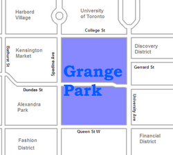
At the heart of the Neighbourhood lies Grange Park itself. The park was created in 1911, when Harriett Boulton gifted her family property to be home for a new Art Museum of Toronto (later evolving into the Art Gallery of Ontario). Upkeep of the expansive gardens to the south of Grange House was entrusted to the City of Toronto, which has maintained the lands as a public park ever since.

In 1852 a fall fair held by the Provincial Agricultural Association of Canada West took place just west of University Avenue from north of Dundas Street to south of College Street. The fair was mainly displaying animals (dairy cattle, sheep, horses), but also a refreshment area, floral hall and a midway (pleasure grounds). [2] This was the second time for Toronto hosting, a fair that would be replaced by the Canadian National Exhibition in 1879.

Character

Shops in Baldwin Village a commercial enclave that has developed around Baldwin Avenue. Baldwin Village.JPG
Shops in Baldwin Village a commercial enclave that has developed around Baldwin Avenue.

Grange Park is a mixed, but predominantly residential neighbourhood. The residential stock varies from working men's cottages built in the 1800s to semi-detached homes to mansions. Many of the buildings have been converted to commercial use, including art galleries within the vicinity of the Art Gallery of Ontario, restaurants and offices. Many of the homes are rented to students of the Ontario College of Art & Design, located on McCaul Street, and the University of Toronto, located to the north.

In the western section, the businesses of Chinatown extend east from Spadina along Dundas to nearly Beverley, while the side streets have remained residential. The eastern section, along University Avenue, is predominantly institutional buildings facing on University Avenue. The buildings are higher than the neighbourhood and more recently built, and have expanded westward into the neighbourhood. Beverley Street north of Dundas has several century-old mansions on both sides of the street, some converted from residential to office uses, and others converted to multi-unit buildings.

East-west, the main street of the neighbourhood is Dundas Street, a street of commercial buildings. North-south, the main streets are Beverly Street and McCaul Street. A commercial enclave has developed around Baldwin Avenue between Beverley and McCaul Streets named 'Baldwin Village' of converted residences housing restaurants of numerous cuisines, and stores of arts, gifts and curios. The residences of the north side of Dundas Street between Beverley and McCaul (across from the AGO) have all been converted to art galleries.

OCAD University's Sharp Centre for Design. The university's campus is located in Grange Park. Toronto - ON - Ontario College of Art & Design2.jpg
OCAD University's Sharp Centre for Design. The university's campus is located in Grange Park.

The homes of the east side of McCaul Street from Dundas south were demolished and the Village by The Grange residential and commercial complex was built. When it was built in 1980, it was a rare example in Toronto of a low-rise apartment complex with mixed commercial uses being built after several decades of high-rise apartment building construction in the downtown core.

Landmarks

Transportation

A streetcar entering the neighbourhood after crossing over University Avenue. The neighbourhood is serviced by several streetcar lines along with subways. Streetcar on Queen, between University and McCaul, 2016 07 16 (2).JPG - panoramio.jpg
A streetcar entering the neighbourhood after crossing over University Avenue. The neighbourhood is serviced by several streetcar lines along with subways.

On the east, three subway stations on the Yonge-University-Spadina subway line stop at College Street (Queen's Park), Dundas Street (St. Patrick and Queen Street (Osgoode). There are streetcar lines on College, Dundas, Queen and Spadina, the Spadina line connecting to the Spadina station on the Bloor-Danforth subway line.

Demographics

Historical population
YearPop.±%
20069,007    
20119,788+8.7%
20169,981+2.0%
202110,487+5.1%

Census tracts 0036.00 and 0037.00 of the 2006 Canadian census cover Grange Park. According to that census, the neighbourhood has 9,007 residents. Average income is $35,277, slightly below the Toronto average. The ten most common languages spoken at home, after English, are:

  1. Unspecified Chinese - 14.8%
  2. Cantonese - 10.0%
  3. Mandarin - 4.6%
  4. Vietnamese - 1.9%
  5. French - 0.8%
  6. Korean - 0.4%
  7. Tagalog - 0.4%
  8. Punjabi - 0.4%
  9. Hebrew - 0.3%
  10. Persian - 0.2%

For Census Tract 5350036.00

According to Statistics Canada, in 2006 the neighbourhood had 4,505 residents. In 2011, this rose by 410 persons to 4915 persons. (Statistics Canada 2006, 2011)

Data on East Asian Ethnic Origin for 2006 and 2011

2006 Percentage Distribution of East Asian Population Origin

OriginAmountPercentage(%)
Korean251.3
Filipino603.2
Japanese603.2
Vietnamese1156
Chinese163586.3
Total1895100

Source: Statistics Canada 2006 Note: Percentages calculated up to one decimal place.

OriginAmountPercentage(%)
Japanese502.2
Korean803.7
Vietnamese1456.6
Filipino1707.8
Chinese174579.7
TotalExample100

2011 Percentage Distribution of East Asian Population Origin - CT 5350036.00

Source: Statistics Canada 2011 GNR: 27.5% Note: Percentages calculated up to one decimal point.

Those identifying as having East Asian origin (Chinese, Filipino, Vietnamese, Japanese and Korean), had increased from 42.1% (1895/4505) of the total population to 44.6% (2190/4915) of the total population between 2006 and 2011. Only those identifying with Japanese Ethnic Origin saw a decrease in population between 2006 and 2011. [3]

Related Research Articles

<span class="mw-page-title-main">Chinatowns in Toronto</span>

Toronto Chinatowns are ethnic enclaves in Toronto, Ontario, Canada, with a high concentration of ethnic Chinese residents and businesses. These neighbourhoods are major cultural, social and economic hubs for the Chinese-Canadian communities of the region. In addition to Toronto, several areas in the Greater Toronto Area also hold a high concentration of Chinese residents and businesses.

<span class="mw-page-title-main">Riverdale, Toronto</span> Neighbourhood in Toronto, Ontario, Canada

Riverdale is a large neighbourhood in Toronto, Ontario, Canada. It is bounded by the Don River Valley to the west, Danforth Avenue and Greektown to the north, Jones Avenue, the CN/GO tracks, Leslieville to the east, and Lake Shore Boulevard to the south.

<span class="mw-page-title-main">Parkdale, Toronto</span> Neighbourhood in Toronto, Ontario, Canada

Parkdale is a neighbourhood and former village in Toronto, Ontario, Canada, west of downtown. The neighbourhood is bounded on the west by Roncesvalles Avenue, on the north by the CP Rail line where it crosses Queen Street and Dundas Street. It is bounded on the east by Dufferin Street from Queen Street south, and on the south by Lake Ontario. The original village incorporated an area north of Queen Street, east of Roncesvalles from Fermanagh east to the main rail lines, today known as part of the Roncesvalles neighbourhood. The village area was roughly one square kilometre in area. The City of Toronto government extends the neighbourhood boundaries to the east, south of the CP Rail lines, east to Atlantic Avenue, as far south as the CN Rail lines north of Exhibition Place, the part south of King Street commonly known as the western half of Liberty Village neighbourhood.

<span class="mw-page-title-main">Queen Street, Toronto</span> Thoroughfare in Toronto, Ontario

Queen Street is a major east–west thoroughfare in Toronto, Ontario, Canada. It extends from Roncesvalles Avenue and King Street in the west to Victoria Park Avenue in the east. Queen Street was the cartographic baseline for the original east–west avenues of Toronto's and York County's grid pattern of major roads. The western section of Queen is a centre for Canadian broadcasting, music, fashion, performance, and the visual arts. Over the past twenty-five years, Queen West has become an international arts centre and a tourist attraction in Toronto.

<span class="mw-page-title-main">Harbourfront, Toronto</span> Neighbourhood in Toronto, Ontario, Canada

Harbourfront is a neighbourhood on the northern shore of Lake Ontario within the downtown core of the city of Toronto, Ontario, Canada. Part of the Toronto waterfront, Harbourfront extends from Bathurst Street in the west, along Queens Quay, with its ill-defined eastern boundary being either Yonge Street or York Street. Its northern boundary is the Gardiner Expressway. Much of the district was former water lots filled in during the early 1900s to create a larger harbour district. After shipping patterns changed and the use of the Toronto harbour declined, the area was converted from industrial uses to a mixed-use district that is mostly residential and leisure.

<span class="mw-page-title-main">Spadina Avenue</span> Thoroughfare in Toronto, Ontario

Spadina Avenue is one of the most prominent streets in Toronto, Ontario, Canada. Running through the western section of downtown, the road has a very different character in different neighbourhoods.

<span class="mw-page-title-main">College Street (Toronto)</span> Street in Toronto, Ontario, Canada

College Street is a principal arterial thoroughfare in downtown Toronto, Canada, connecting former streetcar suburbs in the west with the city centre. The street is home to an ethnically diverse population in the western residential reaches, and institutions like the Ontario Legislature and the University of Toronto in the downtown core. At Yonge Street, College continues to the east as Carlton Street.

<span class="mw-page-title-main">Bishop Strachan School</span> School in Toronto, Ontario, Canada

The Bishop Strachan School is an Anglican day and boarding school for girls in Toronto, Ontario, Canada. The school has approximately 900 students, including 80 boarding students, ranging from Junior Kindergarten to Grade 12. The School is named after John Strachan, the first Anglican bishop of Toronto, and was founded by John Langtry in 1867. The founders' intention was to educate girls to be leaders.

<span class="mw-page-title-main">The Grange (Toronto)</span> Historic site in Toronto, Ontario

The Grange is a historic Georgian manor in downtown Toronto, Ontario. It was the first home of the Art Museum of Toronto. Today, it is part of the Art Gallery of Ontario.

<span class="mw-page-title-main">Grange Park (Toronto)</span> Park in Toronto, Ontario, Canada

Grange Park is a prominent and well-used public park in downtown Toronto, Ontario in Canada. It is located south of the Art Gallery of Ontario, next to the Ontario College of Art and Design University (OCADU) and north of University Settlement House, at the north end of John Street. The Park lends its name to the Grange Park neighbourhood in the vicinity of the park. Historically, the park was the backyard of The Grange, a manor that was later expanded and became the Art Gallery of Ontario.

<span class="mw-page-title-main">Downtown Toronto</span> Central business district in Toronto, Ontario, Canada

Downtown Toronto is the main central business district of Toronto, Ontario, Canada. Located entirely within the district of Old Toronto, it is approximately 16.6 square kilometres in area, bounded by Bloor Street to the northeast and Dupont Street to the northwest, Lake Ontario to the south, the Don Valley to the east, and Bathurst Street to the west. It is also the home of the municipal government of Toronto and the Government of Ontario.

<span class="mw-page-title-main">Baldwin Village</span> Neighbourhood in Toronto, Ontario, Canada

Baldwin Village is a commercial enclave in Toronto, Ontario, Canada. It is located in the west of downtown Toronto, within the Grange Park neighbourhood, one block north of Dundas Street West, between Beverley and McCaul Streets. The former modestly sized homes on the street have been converted to restaurants and small shops selling arts, crafts and curios.

<span class="mw-page-title-main">Discovery District</span> Neighbourhood in Toronto, Ontario, Canada

The Discovery District is one of the commercial districts in Downtown Toronto, Ontario, Canada. It has a high concentration of hospitals and research institutions, particularly those related to biotechnology. The district is roughly bounded by Bloor Street on the north, Bay Street on the east, Dundas Street on the south, and Spadina Avenue on the west.

<span class="mw-page-title-main">Alexandra Park, Toronto</span> Neighbourhood in Toronto, Ontario, Canada

Alexandra Park is a neighbourhood located in downtown Toronto, Ontario, Canada. Alexandra Park is bounded by Dundas Street West on the north, Spadina Avenue on the east, Queen Street West on the south, and Bathurst Street on the west. Alexandra Park consists of private and public housing, with at grade retail along Queen Street West and Spadina Avenue, some institutional, and several commercial buildings scattered through the neighborhood. The neighborhood takes its name from Alexandra Park, a municipal park at the south-east corner of Dundas Street West and Bathurst Street. The park is named for Queen Alexandra, whose husband, King Edward VII, was the first future monarch to visit Toronto.

<span class="mw-page-title-main">Beverley Street</span> Minor street located in central Toronto, Ontario

Beverley Street is a minor road and major bike route located in the central area of Toronto, Ontario. The street was put in place in the 1870s, with large and coveted lots alongside. It is of general consensus among locals that the road acts as the division between the Grange and Baldwin Village neighborhoods on the east side of the street and Toronto's main Chinatown on the west side, respectively. It is designated bicycle route #35 in Toronto's cycle network.

<span class="mw-page-title-main">Dundas Street</span> Major arterial road in Ontario, Canada

Dundas Street is a major historic arterial road in Ontario, Canada. The road connects the city of Toronto with its western suburbs and several cities in southwestern Ontario. Three provincial highways—2, 5, and 99—followed long sections of its course, although these highway segments have since been downloaded to the municipalities they passed through. Originally intended as a military route to connect the shipping port of York to the envisioned future capital of London, Ontario, the street today connects Toronto landmarks such as Yonge–Dundas Square and the city's principal Chinatown to rural villages and the regional centres of Hamilton and London.

<span class="mw-page-title-main">Chinatown, Toronto</span> Neighbourhood in Toronto, Ontario, Canada

Chinatown, Toronto is a Chinese ethnic enclave located in the city's downtown core of Toronto, Ontario, Canada. It is centred at the intersections of Spadina Avenue and Dundas Street, West.

References

  1. GeoSearch
  2. "Early CNE".
  3. 2011 NHS/ 2006 Census