CityPlace, Toronto

Last updated

CityPlace
Neighbourhood
Concord Cityplace 2022.jpg
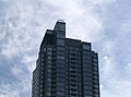
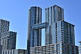
View of western CityPlace (2022)
CityPlace map.PNG
Vicinity
Toronto map.png
Red pog.svg
Location within Toronto
Coordinates: 43°38′24″N79°23′43″W / 43.640044°N 79.395179°W / 43.640044; -79.395179
CountryCanada
Province Ontario
CityToronto
Government
   MP Kevin Vuong (Spadina—Fort York)
   MPP Chris Glover (Spadina—Fort York)
   Councillor Ausma Malik (Ward 10 Spadina—Fort York)
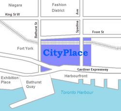
CityPlace is a neighbourhood in Downtown Toronto, Ontario, Canada, within the former Railway Lands. When completed, this area will be the largest residential development ever created in Toronto. The area is bordered by Bathurst Street to the west, Lake Shore Boulevard to the south, and Front Street to the north and Blue Jays Way and Rogers Centre to the east. Cityplace is also a five-to-ten-minute walk from King Street West and Liberty Village and a ten-to-twenty-minute walk from Toronto's financial district. The neighbourhood is also home to the Canoe Landing Park, designed by famed Canadian writer and artist Douglas Coupland.

Contents

History

Early history

What is now CityPlace was originally conceived as a way to revitalize what was Canadian National's former Spadina Street Yard Facility, which was part of the extensive Railway Lands in the waterfront area.

Railway Lands west of the CN Tower in 1999, shortly before new developments transformed the area into CityPlace in the early 21st century. Looking West from the CN Tower, Toronto, Ontario -- 2008-05-10.jpg
Railway Lands west of the CN Tower in 1999, shortly before new developments transformed the area into CityPlace in the early 21st century.

Going as far back as 1965, when CN began to shift the functions of many of its yards in the Greater Toronto Area to a centralized facility in the northern suburb of Vaughan, there had been plans to revitalize this part of downtown. One of them called for the construction of a large television/telecommunications tower as a showcase of Canadian industry, which was realized in the 1970s with the CN Tower in addition to the massive Metro Centre which was later cancelled. Further development took place in the 1980s, with the 1984 completion of the Metro Toronto Convention Centre drawing new attention to the area.

With the arrival of new visitors and development of new commercial draws, a fresh master plan was drawn up by the City of Toronto for revitalization of this area. At the same time Via Rail, the sole remaining occupant of the Spadina Street Yards, relocated their local operations to the newly built Toronto Maintenance Centre in New Toronto, freeing up the lands necessary for the planned revitalization. Work commenced after the demolition of the last railway buildings with the construction of SkyDome, which was completed in 1989.

At the same time, a new network of roads, parks and infrastructure began to take shape. The project proceeded smoothly until an economic downturn caused many of the development plans to be shelved, and much land stood abandoned until 1997 when construction of the Air Canada Centre arena commenced.

Redevelopment

Construction in CityPlace in 2008, looking south from the Union Station Rail Corridor. CityPlace reached its final phase of redevelopment in the early 21st century. CityPlace Towers Building Toronto.jpg
Construction in CityPlace in 2008, looking south from the Union Station Rail Corridor. CityPlace reached its final phase of redevelopment in the early 21st century.

This began the third and final phase of redevelopment called CityPlace which called for a multipurpose development of commercial, residential, and retail along the western section of the Railway Lands. The current CityPlace development was conceived by Concord Adex Developments, the same company that helped revitalize a large section of former Expo 86 lands in Vancouver, who purchased the land in 1997 from the Canada Lands Company. [1]

The final portion of CityPlace to be developed is Block 31. Initially, the proposal for Block 31 included a 42-storey mixed-use tower (alongside schools and community centre). It was criticized for the shadows it would cast over nearby amenity spaces and the site's adjoining Canoe Landing Park, as well as the views it would partially obstruct. [2]

Following a round of public consultations in early 2015, the new schematic design for Block 31 was revealed. It will include two schools and a new community centre. Toronto District School Board (TDSB) and the Toronto Catholic District School Board (TCDSB) have both been designated to use the new space. The shared school building will seek to maximize spatial efficiency, with a common gym and theatre complex for both schools. Block 31's design attempts to maximize available green space. With an articulated green roof spanning the complex's footprint. [3] The 150,000 square foot complex is expected to cost $55 million to construct, and is set to be completed by 2019. [4] The schools are Jean Lumb Public School, named after Jean B. Lumb, the first Chinese Canadian woman and the first restaurateur to receive the Order of Canada for her community work; and Bishop MacDonell Catholic School, which is named after Alexander Macdonell, the first bishop of Kingston in Upper Canada

Project scope

Canoe Landing Park is a 3.24 hectares (8.0 acres) park in CityPlace. Cityplacepark.jpg
Canoe Landing Park is a 3.24 hectares (8.0 acres) park in CityPlace.
  • Project size: 18 hectares (44 acres) including an 8-hectare (20-acre) [5] community park. 7500 residential units upon completion.
  • Residential development is divided into 10 street blocks, numbered from 1 to 10. Each street block contains a number of residential towers with its own sets of common facilities.
  • Block 1 was developed first with 4 towers, namely Matrix A/B (Completed 2002) and Apex C/D (Completed 2003), all with Front Street West addresses. The street block features buildings directly facing the entertainment district and the closest walk to the Financial District.
  • Block 2 features 1 building (Optima) only, directly behind the Rogers Centre, fronting on Navy Wharf Court. It features a heightened privacy comparing to the other interconnected towers. Completed 2003.
  • Block 3 is the largest street block in the entire CityPlace complex, with 4 towers and a mid-rise building, as well as townhouses to decrease the tension of high density development. The project was named Harbour View Estates and was completed in 2006.
  • Block 4 features 2 towers and a mid-rise, mirroring the Harbour View Estates both in location and in design. The buildings are named as WestOne, N1/N2 and The Gallery, was completed by October 2007.
  • Block 5 contains one tower (Montage), completed in early 2009, and a mid-rise building (Neo), completed in late 2008.
  • Block 6 has further progressed in design as trend evolves, with 2 towers and 1 mid-rise, Luna and Luna Vista. Completed April 2010
  • Block 7-8 (Parade) Two towers with a 2-story bridge at floors 28 and 29, 2 podium buildings and 2 mid-rise buildings. Completed 2013.
  • Block 9 contains the 3.24 hectares (8.0 acres) Canoe Landing Park [6]
  • Block 10 will contain the Panorama building with a 7-story podium/mid-rise and a luxury high rise. The high-rise will feature a number of 1500+sqft units with private elevators. Completed April 2010.
  • Number of Units: over 5,000 residential units to date.

Notable landmarks

RankNameHeight
ft
FloorsStartedCompletedAddressNotesImage
Apex C [A] 273 ft (83.2 m)2820012003381 Front Street West CityPlace Apex.JPG
Apex D [A] 371*3620012003397 Front Street West
Concord Canada House A [A] 592018 Octoberunder construction23 Spadina Avenue
Concord Canada House B [A] 692018 Octoberunder construction
Exchange [A] 8201890 Queens Wharf Road
Forward [A] 30201870 Queens Wharf Road
Gallery [A] 108.3 ft (33.0 m)82005 September2007 July15 Brunel Court
Harbourview Estates A [A] 402 ft (122.5 m)402003 January200510 Navy Wharf Court Harbourview Estates buildings.jpg
Harbourview Estates B [A] 503 ft (153.3 m)492003 January200535 Mariner Terrace
Harbourview Estates C [A] 278 ft (84.7 m)*26200420053 Navy Wharf Court
Harbourview Estates D [A] 378 ft (115.2 m)*36200420055 Mariner Terrace
Harbourview Estates Loft [A] 85.3 ft (26.0 m)*8200420059 Spadina Avenue
Luna [A] 229.7 ft (70.0 m)222007 January2010 April8 Telegram Mews
Luna Vista [A] 413 ft (125.9 m)382007 January2010 April25 Capreol Court Luna vista.jpg
Matrix A [A] 320 ft (97.5 m)3220002002361 Front Street West MATRIXAB.jpg
Matrix B [A] 274 ft (83.5 m)2820002002373 Front Street West
Montage [A] 476 ft (145.1 m)472006 November2009 February25 Telegram Mews CityPlace Montage.JPG
N [A] 425 ft (129.5 m)*412005 June2007 August15 Fort York Boulevard N2, The top, Toronto.jpg
Neo [A] 210 ft (64.0 m)162006 June2008 October4K Spadina Avenue
Newton [A] 21201880 Queens Wharf Road
Optima [A] 357.6 ft (109.0 m)342001200381 Navy Wharf Court
Panorama [A] 315 ft (96.0 m)*282008 January2010 April38 Dan Leckie Way Cityplacepanorama.jpg
Parade 1 [A] 366 ft (111.6 m)392008 January201315 Iceboat Terrace / 10 Caperol Court CityPlaceSkyBridge3.JPG
Parade 2 [A] 418 ft (127.4 m)442008 January2012 November21 Iceboat Terrace / 151 Dan Leckie Way
Quartz [A] 41201575 Queens Wharf Road
Spectra [A] 39201585 Queens Wharf Road
The LakeFront [A] 41202017 Bathurst Street, Toronto
The LakeShore [A] 41202019 Bathurst Street, Toronto
West One [A] 486 ft (148.1 m)4920052007 October11 Brunel Court CityPlace West One.JPG
Jean Lumb Public School (TDSB)

Bishop Macdonell Catholic Elementary School (TCDSB)

32017 September2019 September20 Brunel Court

(*) – denotes estimate
See Concord Pacific Masterplan in External Links

Transportation

Southbound streetcars from the 510 Spadina line enters CityPlace. The 510 Spadina is one of three streetcar lines that operate in the area. The two Flexity Outlooks in service on 2014 08 31 pass on the railway bridge south of Front. (2) (15110060092).jpg
Southbound streetcars from the 510 Spadina line enters CityPlace. The 510 Spadina is one of three streetcar lines that operate in the area.

With its location nestled between the Gardiner Expressway and Union Station, CityPlace is a very accessible area. The development is also serviced by the Toronto Transit Commission's 509 Harbourfront, 510 Spadina, and 511 Bathurst streetcar lines.

In addition, a median is being set aside along Fort York Boulevard, the main thoroughfare through Cityplace, so that it can be used for a streetcar route by the TTC in the future.

A footbridge (Puente de Luz or Bridge of Light) is a pedestrian and cycling crossing from CityPlace to Front Street across the railway tracks was opened in October 2012, but promptly closed due to concerns over the sharpness of clips holding the controversial mesh to the sides of the bridge, as well as concerns over people tripping at joins while using the bridge. Those issues were dealt with, and the bridge reopened in December 2012. [7] The 100m bridge is designed by sculptor Francisco Gazitua of Chile. [8]

Criticism

Some planners, architects and politicians have questioned the prudence of the development's urban design. Critics have lauded the architectural excellence of the buildings themselves, but believe suburban ideals have been engineered into the streetscape. [9] While not opposed to high density, critics cite the project's isolation as a potential hindrance to the future health of the fledgling community. They believe that as with other Toronto high rise developments in the past, CityPlace's lack of interconnectedness with the surrounding city may lead to ghettoization of residents. [10] Others believe community prosperity may be affected by the upward mobility of current purchasers. A lack of large units deters families from choosing CityPlace as a desirable place to live, threatening to recreate the conditions experienced in St. James Town and Regent Park, based on a dated article from 2007. [11] However, as the debate continues, proponents with a more optimistic view towards CityPlace's future have cited developments such as Canoe Landing Park, the rising prestige of the adjacent King West area and other future developments on the horizon in the Toronto Entertainment District as evidence of Cityplace's success. [12]

See also

Related Research Articles

<span class="mw-page-title-main">Toronto Islands</span> Chain of islands in Lake Ontario

The Toronto Islands are a chain of 15 small islands in Lake Ontario, south of mainland Toronto, Ontario, Canada.

<span class="mw-page-title-main">Regent Park</span> Neighbourhood in Toronto, Ontario, Canada

Regent Park is a neighbourhood located in downtown Toronto, Ontario built in the late 1940s as a public housing project managed by Toronto Community Housing. It sits on what used to be a significant part of the Cabbagetown neighbourhood and is bounded by Gerrard Street East to the north, River Street to the east, Shuter Street to the south and Parliament Street to the west. Regent Park's residential dwellings, prior to the ongoing redevelopment, were entirely social housing and covered all of the 69 acres (280,000 m²) which comprise the community. The original neighbourhood was razed in the process of creating Regent Park. The nickname Cabbagetown is now applied to the remaining historical, area north and west of the housing project, which has experienced considerable gentrification since the 1960s and 1970s.

<span class="mw-page-title-main">Queen Street, Toronto</span> Thoroughfare in Toronto, Ontario

Queen Street is a major east–west thoroughfare in Toronto, Ontario, Canada. It extends from Roncesvalles Avenue and King Street in the west to Victoria Park Avenue in the east. Queen Street was the cartographic baseline for the original east–west avenues of Toronto's and York County's grid pattern of major roads. The western section of Queen is a centre for Canadian broadcasting, music, fashion, performance, and the visual arts. Over the past twenty-five years, Queen West has become an international arts centre and a tourist attraction in Toronto.

<span class="mw-page-title-main">Harbourfront, Toronto</span> Neighbourhood in Toronto, Ontario, Canada

Harbourfront is a neighbourhood on the northern shore of Lake Ontario within the downtown core of the city of Toronto, Ontario, Canada. Part of the Toronto waterfront, Harbourfront extends from Bathurst Street in the west, along Queens Quay, with its ill-defined eastern boundary being either Yonge Street or York Street. Its northern boundary is the Gardiner Expressway. Much of the district was former water lots filled in during the early 1900s to create a larger harbour district. After shipping patterns changed and the use of the Toronto harbour declined, the area was converted from industrial uses to a mixed-use district that is mostly residential and leisure.

<span class="mw-page-title-main">Toronto waterfront</span> Shore of Lake Ontario in Toronto, Canada

The Toronto waterfront is the lakeshore of Lake Ontario in the city of Toronto, Ontario, Canada. It spans 46 kilometres between the mouth of Etobicoke Creek in the west and the Rouge River in the east.

<span class="mw-page-title-main">Spadina Avenue</span> Thoroughfare in Toronto, Ontario

Spadina Avenue is one of the most prominent streets in Toronto, Ontario, Canada. Running through the western section of downtown, the road has a very different character in different neighbourhoods.

<span class="mw-page-title-main">Beltline, Calgary</span> Neighbourhood in Calgary, Alberta, Canada

Beltline is a region of central Calgary, Alberta, Canada. The area is located immediately to the south of Calgary's downtown, and is sometimes considered part of downtown. The neighbourhood is bounded on the south by 17th Avenue, on the west by 14th Street West and on the east by the Elbow River. Beltline is one of Calgary's most densely populated neighbourhoods as well as the most urban, featuring many apartments, condominiums and offices. It has the reputation of being one of Calgary's primary areas for eclectic night-life, restaurants and urban culture.

<span class="mw-page-title-main">Front Street (Toronto)</span> Thoroughfare in Toronto, Ontario

Front Street is an east–west road in downtown Toronto, Ontario, Canada. First laid out in 1796, the street is one of the original streets of the Town of York. The street was laid out along the shoreline of Lake Ontario as it existed during that time. It remains an important street, with many important uses located along it, including the St. Lawrence Market, Meridian Hall, Union Station and the Metro Toronto Convention Centre. The eastern section of Front Street, in the West Don Lands, east of Cherry Street, is being rebuilt as a broad tree-lined boulevard, intended to be the pedestrian-friendly commercial spine of the new neighbourhood.

<span class="mw-page-title-main">Vaughan Metropolitan Centre</span> City centre in Ontario, Canada

Vaughan Metropolitan Centre is the city centre of Vaughan, Ontario, Canada. Measuring 179 hectares, the district is located at the intersection of Highway 7 and Jane Street, northeast of the Highway 400 and Highway 407 interchange, at the site of the historic farming community of Edgeley within the larger district of Concord. The district is served by the TTC subway station of the same name, which is the northwestern terminus of Line 1 Yonge–University of the Toronto subway system. It is also a major transit hub for York Region Transit (YRT), as well as Viva and Züm bus rapid transit services.

<span class="mw-page-title-main">Wascana Centre</span> Urban park in Saskatchewan, Canada

Wascana Centre is a 930-hectare urban park built around Wascana Lake in Regina, Saskatchewan, Canada, established in 1912 with a design from renowned architect Thomas Mawson. The park is designed around the Saskatchewan Legislative Building and Wascana Lake. High-profile features include the University of Regina, Royal Saskatchewan Museum, Conexus Arts Centre, Saskatchewan Science Centre, and CBC Regional Broadcast Centre. Wascana Centre brings together lands and buildings owned by the City of Regina, University of Regina, and Province of Saskatchewan. The park is located immediately south of the city's downtown core, bordered by residential areas on the east, south and west, and on the south-east edge it spills out onto open Saskatchewan prairie along Wascana Creek.

<span class="mw-page-title-main">Fashion District, Toronto</span> Neighbourhood in Toronto, Ontario, Canada

The Fashion District is a commercial and residential district in Downtown Toronto, Ontario, Canada. It is located between the intersection of Bathurst Street to the west, Spadina Avenue to the east, Queen Street West to the north and Front Street to the south. Google Maps extends the district further east of Spadina Avenue to Peter Street.

<span class="mw-page-title-main">Architecture of Toronto</span> Overview of the architecture of Toronto

The architecture of Toronto is an eclectic combination of architectural styles, ranging from 19th century Georgian architecture to 21st century postmodern architecture and beyond.

<span class="mw-page-title-main">Concord Park Place</span> Development in Toronto, Ontario, Canada

Concord Park Place is a 45-acre (18 ha) multi-tower condominium complex under construction by developer Concord Adex in Toronto, Ontario.

<span class="mw-page-title-main">Railway Lands</span> Redevelopment district in Toronto, Ontario, Canada

Railway Lands is an area in Downtown Toronto, Ontario, Canada. Originally a large railway switching yard near the Toronto waterfront, including the CNR Spadina Roundhouse and the CPR John Roundhouse, it has since been redeveloped and today is home to mostly mixed-used development, including the CN Tower and the Rogers Centre. The lands were owned and maintained by the Canadian National Railway and later transferred to the federal crown corporation Canada Lands Company. The area is bounded by Front Street, Yonge Street, Gardiner Expressway and Bathurst Street. The western portion of the Railway Lands is now part of the CityPlace neighbourhood and the eastern portion is now called South Core.

<span class="mw-page-title-main">Grange Park (neighbourhood)</span> Neighbourhood in Toronto, Ontario, Canada

Grange Park is a neighbourhood in downtown Toronto, Ontario, Canada. It is bounded on the west by Spadina Avenue, on the north by College Street, on the east by University Avenue and on the south by Queen Street West. It is within the 'Kensington-Chinatown' planning neighbourhood of the City of Toronto. Its name is derived from the Grange Park public park. The commercial businesses of Chinatown extend within this neighbourhood.

<span class="mw-page-title-main">Downtown East Village, Calgary</span> Neighbourhood in Calgary, Alberta, Canada

Downtown East Village more commonly known as simply East Village, is a mixed-use neighbourhood within the eastern portions of downtown Calgary, Alberta, Canada. It is contained within the city's Rivers District. Containing the earliest-settled land in the Calgary area - Fort Calgary - East Village was for years a mixture of high-rise residential, commercial, and industrial development. Much of the parkland currently surrounding Fort Calgary was industrial as recently as the 1960s. Construction of the city's light rail transit Blue Line, coupled with the closure of 8th Avenue at Macleod Trail in the early 1980s by construction of the massive Calgary Municipal Building, resulted in East Village being "cut off," from the rest of downtown. It became home to many rundown properties and vacant lots over the years, and a severe crime problem.

<span class="mw-page-title-main">Architecture of Vancouver</span>

The architecture of Vancouver and the Greater Vancouver area consists of a variety of modern architectural styles, such as the 20th-century Edwardian and the 21st-century modernist styles. Initially, the city architects embraced styles developed in Europe and the United States, with only limited local variation.

<span class="mw-page-title-main">Massey Tower</span> Building complex in Toronto, Ontario, Canada

Massey Tower is a new complex in Toronto, Ontario, Canada, spanning the block below Shuter Street, between Yonge and Victoria streets. The complex's northeast corner added much-needed backstage space to historic Massey Hall. To the south of the complex lies the historic Elgin and Winter Garden Theatres. The Yonge Street facade uses the 1905 Canadian Bank of Commerce headquarters at 197 Yonge Street, vacant since 1987. The complex's tower rises 60 storeys and stands 208.3 metres (683 ft) in height.

<span class="mw-page-title-main">The Esplanade (Toronto)</span> East-west street in Toronto, Canada

The Esplanade is an east-west street along the central waterfront of Toronto, Ontario, Canada. This neighbourhood consists of generally low-rise and mid-rise housing - condominiums, public housing, cooperatives and some town homes between Jarvis and Parliament Streets south of Front Street. The stretch between Scott Street and Market Street is a popular restaurant area.

<span class="mw-page-title-main">BDP Quadrangle (architecture firm)</span> Canadian architecture and interior design firm

BDP Quadrangle is the North American studio of UK-based global architecture, design, and urbanism firm, BDP.

References

  1. Lee-Shanok, Philip (2018-12-17). "Canada House: Last piece of the City Place puzzle falls into place". Toronto: CBC News. Retrieved 2020-03-14.
  2. "Concept Plan Revealed for CityPlace Schools and Community Centre". UrbanToronto. Urban Toronto / CHART Communications Inc. Retrieved 7 August 2015.
  3. "Concept Plan Revealed for CityPlace Schools and Community Centre". UrbanToronto. Urban Toronto / CHART Communications Inc. Retrieved 7 August 2015.
  4. Ghebrelassie, Makda (7 July 2015). "CityPlace condo community plans new schools, daycare". CBC/Radio-Canada. CBC. Retrieved 7 August 2015.
  5. After months of hurdles, Canoe Landing Park opens , retrieved 2011-12-05
  6. PFS Studio Commons Projects, archived from the original on 2014-08-26, retrieved 2014-08-23
  7. Puente De Luz Bridge Re-opens | Urban Toronto 2012-12-18
  8. Photo of the Day: Bridge of Light Pours across CityPlace | Urban Toronto. Urbantoronto.ca (2012-03-27). Retrieved on 2013-07-26.
  9. Hume, Christopher. (July 14, 2007). City Place Hurt by New Spadina Expressway The Toronto Star .
  10. Hume, Christopher. (April 21, 2007). "Some causes for concern in condo design." Retrieved on 2008-08-16
  11. Tossell, Ivor. (September 1, 2007). High Stakes The Globe and Mail
  12. Hume, Christopher. (March 13, 2010). Cityplace proving its critics wrong The Toronto Star