Old Mill, Toronto

Last updated

Old Mill
Neighbourhood
Right Near Jane and Bloor.jpg
Looking north on Jane Street, with the neighbourhood located west of the roadway
Old Mill map.png
CountryFlag of Canada (Pantone).svg  Canada
Province Flag of Ontario.svg  Ontario
City Toronto
Established1850 (York Township)
Changed municipality1998 Toronto from York
Government
   MP Arif Virani (Parkdale—High Park)
   MPP Bhutila Karpoche (Parkdale—High Park)
   Councillor Gord Perks (Ward 4 Parkdale—High Park)

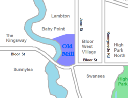
Old Mill is a neighbourhood of Toronto, Ontario, Canada on the banks of the Humber River. It is located north and west of the intersection of Bloor Street and Jane Street. The area takes its name from the old grist mill ruins on the west bank of the river, now converted into a hotel (also named "Old Mill"). The City of Toronto includes this neighbourhood in the official "Lambton Baby Point" neighbourhood which includes the Baby Point enclave and former Lambton village areas to the north.

Contents

Character

The neighbourhood's houses are primarily single-family detached homes, built before and after the Second World War. The Old Mill Inn & Spa is located in the neighbourhood on the west side of the Humber River in Etobicoke. Most of the area is on a slope leading down from Jane and Bloor Streets, into the Humber valley. One street, Halford Avenue, is paved with brick, cobblestones or paving stones. Several of the more steep streets can become impassable in the wintertime.

Along Bloor Street, two condominium developments replaced an auto dealer. Some businesses exist on the north side of Bloor Street and the west side of Jane around the intersection. There is a film theatre, the Humber Cinema multiplex at the intersection of Bloor and Jane. The Humber Cinema closed on May 30, 2019.

History

View of Old Mill, c. 1900s. The area bears the name of the Old Mill, which is situated west of the neighbourhood. Old Mill restaurant, Toronto.jpg
View of Old Mill, c. 1900s. The area bears the name of the Old Mill, which is situated west of the neighbourhood.

Historically, it was a hunting and fishing area for First Nations. A native village existed just to the north at Baby Point before European colonisation. By 1720, the French had established a small fortified settlement called Magasin Royal, near the present site of the Old Mill, for trading with native bands. By 1800, the first English settlement in the area was around the Kings Mill, used to cut lumber for the first homes in York, Upper Canada, now known as Toronto. A series of mills were constructed, until the last one was abandoned in 1881.

After 1900, the area was laid out for residential uses. The Old Mill Tea Room was used as a community centre as the area was developed. The neighbourhood was part of York Township. The extreme south edge of the land was part of Swansea, and lands along Jane Street were a part of Toronto. York became the Borough of York, then the City of York and was finally merged into the amalgamated City of Toronto in 1998.

Transportation

Jane station is a subway station located southeast of the neighbourhood. Jane Station cropped.jpg
Jane station is a subway station located southeast of the neighbourhood.

Old Mill Drive connects to Bloor Street West at its southern end. Across the Humber River to the west is the neighbourhood's namesake subway station, with a unique partially elevated design above the Humber River. The 66 Prince Edward bus route runs from this station south to Humber Bay Park and Humber Loop, where connections are available to the 501 Queen streetcar route.

Several of the neighbourhood streets connect to Jane Street, which has regular bus service operated by the TTC. Jane subway station is located at its southern end where it intersects Bloor Street. Both Jane and Old Mill stations are located on Line 2 of the subway network and have frequent service towards Downtown Toronto.

43°39′08″N79°29′21″W / 43.6521°N 79.4893°W / 43.6521; -79.4893

Related Research Articles

<span class="mw-page-title-main">The Kingsway, Toronto</span> Neighbourhood in Toronto, Ontario, Canada

The Kingsway is a residential neighbourhood in Toronto, Ontario, Canada. It is bounded by Bloor Street to the south, Dundas Street to the north, the Mimico Creek to the west and the Humber River to the east. The neighbourhood was officially known as Kingsway Park, which later became replaced by its nickname, The Kingsway. For planning purposes, the neighbourhood is known by the City of Toronto as "Kingsway South" to differentiate it from a more recent extension of The Kingsway north of Dundas Street. "Kingsway South" is not used by residents, due to confusion with the South Kingsway, a street located east of the Humber River and extending south from Bloor Street.

<span class="mw-page-title-main">Baby Point</span> Neighbourhood in Toronto, Ontario, Canada

Baby Point is a residential neighbourhood in Toronto, Ontario, Canada. It is bounded on the west by the Humber River from south of Baby Point Crescent to St. Marks Road, east to Jane Street and Jane Street south to Raymond Avenue and Raymond Avenue west to the Humber. It is within the city-defined neighbourhood of 'Lambton-Baby Point'. Baby Point is within the proximity of Jane station.

<span class="mw-page-title-main">Humber River—Black Creek</span> Federal electoral district in Ontario, Canada

Humber River—Black Creek is a federal electoral district in Toronto, Ontario, Canada, that has been represented in the House of Commons of Canada from 1867 to 1904 and since 1917. Prior to the 2015 election, the riding was known as York West. The former name reflects the riding is in the former Township of York which is within the City of Toronto.

<span class="mw-page-title-main">Teiaiagon</span>

Teiaiagon was an Iroquoian village on the east bank of the Humber River in what is now the York district of Toronto, Ontario, Canada. It was located along the Toronto Carrying-Place Trail. The site is near the current intersection of Jane Street and Annette Street, at which is situated the community of Baby Point.

<span class="mw-page-title-main">Old Mill station</span> Toronto subway station

Old Mill is a subway station on Line 2 Bloor–Danforth of the Toronto subway in Toronto, Ontario, Canada. It is located at 2672 Bloor Street West at Old Mill Terrace and Humber Boulevard in the Kingsway residential neighbourhood. Nearby destinations include the Old Mill Inn and Park Lawn Cemetery. Wi-Fi service is available at this station.

<span class="mw-page-title-main">Jane station</span> Toronto subway station

Jane is a subway station on Line 2 Bloor–Danforth of the Toronto subway in Toronto, Ontario, Canada. It is located just north of Bloor Street West, spanning the block east of Jane Street to Armadale Avenue, with entrances from all three streets. It opened in 1968 as part of the westerly extension from Keele to Islington Station. Wi-Fi service is available at this station.

<span class="mw-page-title-main">Sheppard Avenue</span> Road in Toronto, Ontario, Canada

Sheppard Avenue is an east–west principal arterial road in Toronto, Ontario, Canada. The street has two distinct branches near its eastern end, with the original route being a collector road leading to Pickering via a turnoff, and the main route following a later-built roadway which runs south to Kingston Road. To avoid name duplication, the Toronto portion of the northern branch was renamed Twyn Rivers Drive. The section of the street entirely in Toronto is (34.2 km) in length, while the Pickering section and Twyn Rivers Dr. is (5.4 km) long.

<span class="mw-page-title-main">Bathurst Street (Toronto)</span> Street in Toronto and York Region in Ontario, Canada

Bathurst Street is a main north–south thoroughfare in Toronto, Ontario, Canada. It begins at an intersection of the Queens Quay roadway, just north of the Lake Ontario shoreline. It continues north through Toronto to the Toronto boundary at Steeles Avenue. It is a four-lane thoroughfare throughout Toronto. The roadway continues north into York Region where it is known as York Regional Road 38.

<span class="mw-page-title-main">Étienne Brûlé Park</span>

Étienne Brûlé Park is located in the Humber River valley just north of Bloor Street West in Toronto, Ontario, Canada. It is named after Étienne Brûlé, an early French explorer in the Toronto area. It is believed that Étienne Brûlé was the first European to see Lake Ontario in 1615, from a high point of land beside the Humber.

<span class="mw-page-title-main">Downtown Toronto</span> Central business district in Toronto, Ontario, Canada

Downtown Toronto is the main central business district of Toronto, Ontario, Canada. Located entirely within the district of Old Toronto, it is approximately 16.6 square kilometres in area, bounded by Bloor Street to the northeast and Dupont Street to the northwest, Lake Ontario to the south, the Don Valley to the east, and Bathurst Street to the west. It is also the home of the municipal government of Toronto and the Government of Ontario.

<span class="mw-page-title-main">Humber Valley Village</span> Neighbourhood in Toronto, Ontario, Canada

Humber Valley Village is a neighbourhood located in Toronto, Ontario, Canada. It is within the former suburb of Etobicoke and includes some of the most expensive real estate in the metropolitan west end. The boundaries are from Dundas Street on the south to Islington Avenue to the west, Eglinton Avenue to the north, and the Humber River in the east. The neighbourhood is in the political riding of Etobicoke Centre.

<span class="mw-page-title-main">Rockcliffe–Smythe</span> Neighbourhood in Toronto, Ontario, Canada

Rockcliffe–Smythe is a neighbourhood in Toronto, Ontario, Canada. It was developed after World War II as part of the urbanization of the former suburb of York Township. It is in Ward 5 in the City of Toronto.

<span class="mw-page-title-main">The Queensway–Humber Bay</span> Neighbourhood in Toronto, Ontario, Canada

The Queensway–Humber Bay, known officially as Stonegate–Queensway, is a neighbourhood in the southwest of Toronto, Ontario, Canada. It is located in the southeast area of the former City of Etobicoke.

<span class="mw-page-title-main">Lambton, Toronto</span> Neighbourhood in Canada

Lambton is a neighbourhood in the city of Toronto, Ontario, Canada. It is situated on the east bank of the Humber River north and south of Dundas Street West. It is bounded on the north by Black Creek, on the east by Jane Street and on the south by St. Mark's Road. The area west of Gooch Avenue and south of Dundas Street West is also known as "Warren Park", the name of the housing sub-division built in the 1950s. The portion south of Dundas Street West is within the 'Lambton Baby Point' neighbourhood as defined by the City of Toronto.

<span class="mw-page-title-main">Royal York Road</span> Thoroughfare in Toronto, Ontario

Royal York Road, historically known as Church Street or New Church Street, is a north-south arterial road in Toronto, Ontario, Canada. It is a concession road, 5 concessions (10 km) west of Yonge Street, and runs through many residential neighbourhoods, most notably Mimico and the Kingsway. It is classified as a "minor arterial" road by the city of Toronto.

<span class="mw-page-title-main">Bloor West Village</span> Residential Neighbourhood and Shopping District in Toronto, Ontario, Canada

Bloor West Village is a residential neighbourhood and shopping district in Toronto, Ontario, Canada. Bordered on the south by Bloor Street, it encompasses all businesses along Bloor Street between South Kingsway and Ellis Park Road, consisting of more than 400 shops, restaurants and services, plus the residential neighbourhood to the north. The official City of Toronto name of the neighbourhood is Runneymede-Bloor West Village.

<span class="mw-page-title-main">Runnymede Road</span> Road in Toronto, Canada

Runnymede Road is a street in the west end of Toronto, Canada. It runs from Morningside Avenue at its south end and ends at Henrietta Street, just north of St. Clair Ave. There is a small section continuing but ends in a Cul de sac. At its southern end, it begins as a narrow 2 lane road. It heads north to Bloor Street, where it widens to accommodate bikes lanes. At St. Clair, the bikes lanes stop, and it becomes a 2-way street north until Henrietta.

<span class="mw-page-title-main">Lambton Mills</span> Place in Ontario, Canada

The Village of Lambton Mills was a settlement at the crossing of Dundas Street and the Humber River. The settlement was on both sides of the Humber River, in both the former Etobicoke Township and York Township, within today's City of Toronto, Ontario, Canada. It extended as far west as Royal York Road at Dundas, as far north as the still-existing CPR rail line north of Dundas, as far east as Scarlett Road and as far south as today's Queen Anne Road. The area on the east side of the river is still known as Lambton, although the current neighbourhood encompasses very little of the original Lambton Mills village.

<span class="mw-page-title-main">Dundas Street</span> Major arterial road in Ontario, Canada

Dundas Street is a major historic arterial road in Ontario, Canada. The road connects the city of Toronto with its western suburbs and several cities in southwestern Ontario. Three provincial highways—2, 5, and 99—followed long sections of its course, although these highway segments have since been downloaded to the municipalities they passed through. Originally intended as a military route to connect the shipping port of York to the envisioned future capital of London, Ontario, the street today connects Toronto landmarks such as Yonge–Dundas Square and the city's principal Chinatown to rural villages and the regional centres of Hamilton and London.