
Etobicoke is an administrative district and former city within Toronto, Ontario, Canada. Comprising the city's west end, Etobicoke is bordered on the south by Lake Ontario, on the east by the Humber River, on the west by Etobicoke Creek, the cities of Brampton, and Mississauga, the Toronto Pearson International Airport, and on the north by the city of Vaughan at Steeles Avenue West.

The Humber River is a river in Southern Ontario, Canada. It is in the Great Lakes Basin, is a tributary of Lake Ontario and is one of two major rivers on either side of the city of Toronto, the other being the Don River to the east. It was designated a Canadian Heritage River on September 24, 1999.

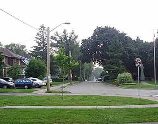
The Kingsway is a residential neighbourhood in Toronto, Ontario, Canada. It is bounded by Bloor Street to the south, Dundas Street to the north, the Mimico Creek to the west and the Humber River to the east. The neighbourhood was officially known as Kingsway Park, which later became replaced by its nickname the Kingsway. In this neighbourhood, the Kingsway specifically refers to a two-lane road beginning in the south-east corner of the neighbourhood extending northerly in a north-west direction past Dundas Street.

New Toronto is a neighbourhood and former municipality in Toronto, Ontario, Canada. It is located in the south-west area of Toronto, along Lake Ontario. The Town of New Toronto was established in 1890, and was designed and planned as an industrial centre by a group of industrialists from Toronto who had visited Rochester, New York. New Toronto was originally a part of the Township of Etobicoke. It was an independent municipality from 1913 to 1967, being one of the former 'Lakeshore Municipalities' amalgamated into the Borough of Etobicoke, and eventually amalgamated into Toronto. The neighbourhood has retained the name.
Mimico is a neighbourhood in Toronto, Ontario, Canada, being located in the south-west area of Toronto on Lake Ontario. It is in the south-east corner of the former Township of Etobicoke, and was an independent municipality from 1911 to 1967.

The Toronto waterfront is the lakeshore of Lake Ontario in the city of Toronto, Ontario, Canada. It spans 46 kilometres between the mouth of Etobicoke Creek in the west and the Rouge River in the east.

Mimico Creek is a stream that flows through Brampton, Mississauga and Toronto in the Greater Toronto Area of Ontario, Canada. It is 33 kilometres (21 mi) long, is in the Great Lakes Basin, and is a tributary of Lake Ontario.

Toronto Harbour or Toronto Bay is a natural bay on the north shore of Lake Ontario, in Toronto, Ontario, Canada. Today, the harbour is used primarily for recreational boating, including personal vessels and pleasure boats providing scenic or party cruises. Ferries travel from docks on the mainland to the Islands, and cargo ships deliver aggregates and raw sugar to industries located in the harbour. Historically, the harbour has been used for military vessels, passenger traffic and cargo traffic. Waterfront uses include residential, recreational, cultural, commercial and industrial sites.

Lake Shore Boulevard is a major arterial road running along more than half of the Lake Ontario waterfront in the city of Toronto, Ontario, Canada. Prior to 1998, two segments of Lake Shore Boulevard were designated as part of Highway 2, with the highway following the Gardiner Expressway between these two sections.

Kipling Avenue is a street in the cities of Toronto and Vaughan in Ontario, Canada. It is a concession road, 6 concessions (12 km) west from Yonge Street, and is a major north–south arterial road. It consists of three separate sections, with total combined length of 26.4 km. (16.4 mi.).

The Queensway is a major street in the municipalities of Toronto and Mississauga, Ontario, Canada. It is a western continuation of Queen Street, after it crosses Roncesvalles Avenue and King Street in Toronto. The Queensway is a divided roadway from Roncevalles westerly until 600 metres of the South Kingsway with its centre median dedicated to streetcar service. The road continues undivided west from there to Etobicoke Creek as a four- or six-lane thoroughfare.
High Park was a federal electoral district in the west-end of the old City of Toronto, in Ontario, Canada. It was represented in the House of Commons of Canada from 1935 to 1972. It was created in 1933 and abolished in 1972, when it was redistributed into the newly created High Park—Humber Valley electoral district, which shared the same boundaries as High Park's 1966 incarnation.
The Toronto and Region Conservation Authority (TRCA) is a conservation authority in southern Ontario, Canada. It owns about 16,000 hectares of land in the Toronto region, and it employs more than 400 full-time employees and coordinates more than 3,000 volunteers each year. TRCA's area of jurisdiction is watershed-based and includes 3,467 square kilometres (1,339 sq mi) – 2,506 on land and 961 water-based in Lake Ontario. This area comprises nine watersheds from west to east – Etobicoke Creek, Mimico Creek, Humber River, Don River, Highland Creek, Petticoat Creek, Rouge River, Duffins Creek and Carruthers Creek.
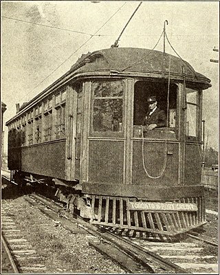
The Toronto and Mimico Electric Railway and Light Company was incorporated in 1890, and operated the Mimico radial line in the Toronto area. The line started operation in 1892 as a short suburban line that later was extended to Port Credit. In 1904, the railway was acquired by the Toronto and York Radial Railway (T&YRR) and became the T&YRR Mimico Division. In 1922, the City of Toronto acquired the T&YRR and contracted Ontario Hydro to manage the four T&YRR lines including the Mimico line. In 1927, the TTC took over the operation of the Mimico line and extended its service eastward to Roncesvalles Avenue. In 1928, the TTC double-tracked the line from Humber to Long Branch and made that portion part of the Lake Shore streetcar line. The portion beyond Long Branch to Port Credit became the Port Credit line, and continued operation as a single-track radial line until its closure on February 9, 1935.

Humber Bay is a bay of Lake Ontario south of Toronto, Ontario, Canada. It is located between Ontario Place on the east and Mimico Creek to the west. The bay gives its name to Etobicoke's Humber Bay neighbourhood.

The Queensway–Humber Bay, known officially as Stonegate–Queensway, is a neighbourhood in the southwest of Toronto, Ontario, Canada. It is located in the southeast area of the former City of Etobicoke.

The Palace Pier is the site of Palace Place and Palace Pier, two cruciform condominium towers tied for the 45th-tallest building in Toronto, Ontario, Canada. They are located at 2045 Lake Shore Boulevard West and 1 Palace Pier Court in the Humber Bay neighbourhood in the former city of Etobicoke.

Grand Harbour is a lakefront condominium community in the Etobicoke district of Toronto, Ontario, Canada. It consists of three condominium towers and several dozen townhouses. Grand Harbour is located on the shore of Lake Ontario just west of Humber Bay Park and Mimico Creek.

The Etobicoke Board of Education, officially known as the Board of Education for the City of Etobicoke is the former public-secular school board administering the schools of Etobicoke, Ontario, headquartered in the Etobicoke Civic Centre. In 1998, it was merged into the Toronto District School Board. The former EBE offices remain in use today by the TDSB as the West Education Office.
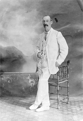
Octavius Laing Hicks was a prominent citizen of Humber Bay in Etobicoke Township. He was born in Dundee, Scotland. He settled in Humber Bay in 1873 and remained there for the rest of his life.


