
Lighthouse Point is a suburb of Fort Lauderdale located in Broward County, Florida, United States. The suburb was named for the Hillsboro Inlet Lighthouse, which is located in nearby Hillsboro Beach. As of the 2010 census, the population of Lighthouse Point was 10,344. Lighthouse Point is a part of the Miami metropolitan area, home to 6,166,488 people at the 2020 census.
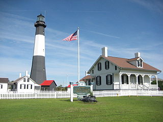
Tybee Island is a city and a barrier island located in Chatham County, Georgia, 18 miles (29 km) east of Savannah, United States. Though the name "Tybee Island" is used for both the island and the city, geographically they are not identical: only part of the island's territory lies within the city.

Hadley is a town in Hampshire County, Massachusetts, United States. The population was 5,325 at the 2020 census. It is part of the Springfield, Massachusetts Metropolitan Statistical Area. The area around the Hampshire and Mountain Farms Malls along Route 9 is a major shopping destination for the surrounding communities.

Amherstburg is a town near the mouth of the Detroit River in Essex County, Ontario, Canada. In 1796, Fort Malden was established here, stimulating growth in the settlement. The fort has been designated as a National Historic Site.

The NCAA Division III Men's Basketball Tournament is a tournament to determine the NCAA Division III national champion. It had been held annually from 1975 through 2019, but has not been played since then due to COVID-19 issues.

Cape Spear is a headland located on the Avalon Peninsula of Newfoundland near St. John's in the Canadian province of Newfoundland and Labrador. At a longitude of 52°37' W, it is the easternmost point in Canada and North America, excluding Greenland.

Fort Washington Park is a public park located in the Washington Heights section of Upper Manhattan in New York City. It runs along the banks of the Hudson River next to Riverside Drive and the Henry Hudson Parkway from West 155th Street to Dyckman Street. The George Washington Bridge crosses above the park, and below the bridge is the small point of land also called Jeffrey's Hook, which is the site of the Little Red Lighthouse.

Cape Wrath Lighthouse at Cape Wrath was built in 1828 by Robert Stevenson and was manned until 1998, when it was converted to automatic operation by the Northern Lighthouse Board. It is located at the most North-Westerly point on the British mainland, in the traditional county of Sutherland within Highland Region. Durness is the closest village, 10 miles (16 km) to the south-east with Inverness around 120 miles (190 km) to the south.

The East Coast Trail (ECT) is a long-distance coastal footpath located in the Canadian province of Newfoundland and Labrador. It is a developed trail over 336 kilometres (209 mi) long, creation of which began in 1994. It is made up of 25 linked wilderness paths and passes through more than 30 communities. It was named one of the best adventure destinations by National Geographic in 2012 and is extended and improved yearly.

Fort Gratiot Light, the first lighthouse in the state of Michigan, was constructed north of Fort Gratiot in 1829 by Lucius Lyon, who later became one of Michigan's first U.S. Senators.

The Crown Point Light on Lake Champlain is a former lighthouse at Crown Point, New York, that now exists as a memorial to the exploration of the lake by Samuel de Champlain.

Fort Amherst is a neighbourhood in St. John's, Newfoundland and Labrador. It is located at 47°33′48.96″N52°40′49.60″W, on the southern side of the Narrows, the entrance to St. John's harbour. Apart from some family dwellings, Fort Amherst consists of a man-made harbour, a lighthouse and the remains of gun emplacements built during World War II to defend against German U-boats. Two QF 4.7-inch B Mark IV* guns remain in place, and can still be seen on their mountings.

Long Island Head Light is an historic lighthouse on Long Island in Boston Harbor, Boston, Massachusetts. The current brick tower is the fourth lighthouse on the island.

Skmaqn–Port-la-Joye–Fort Amherst is a National Historic Site located in Rocky Point, Prince Edward Island.

The Narrows, is the only passage from the Atlantic Ocean to St. John's Harbour, Newfoundland, bordered north and south by steep rock walls. A skilled captain is required to navigate large ships through the Narrows, known as “threading the eye of the needle”. The channel has a least depth of 11 metres and at its narrowest point near Chain Rock is 61 metres wide. From at least circa 1830, metal rings were set into the rock on either side of the Narrows so that boats could "warp in" and be hauled along to clear the cliffs and dangerous rocks in the water. In 1855, work began to blast away the submerged top of the Merlin Rock to make a safer passage for steam ships.

Fort Andrew is a former fort built as Gurnet Fort in 1776 for the American Revolutionary War on Gurnet Point in Plymouth, Massachusetts. It became a federal fort and was rebuilt in 1808, and again in 1863 during the Civil War when it received its current name. It is named for John A. Andrew, governor of Massachusetts 1861–1866. In 1863 Fort Standish was built nearby on Saquish Head. After the war, the federal government declared Fort Andrew an inactive military reservation in 1869. The reservation was sold in 1926 and mostly became private property, except for the US Coast Guard light station. A World War II fire control tower was built on the parapet of the old fort. Plymouth lighthouse is also on Gurnet Point, and was moved inside the fort's earthworks to protect it from beach erosion in 1997–1998.
The Point Abino Light Tower is a lighthouse on the rocky north shore of Lake Erie at the southern tip of Point Abino peninsula west of Crystal Beach, Ontario, Canada. The Greek Revival white square tower with red accents is attached to the fog alarm building, and a lighthouse keeper's residence is located on the shore to the north.

Forte de Santo Antônio da Barra is a fort located in Salvador, Bahia, Brazil. It was constructed to guard the entrance to the Bay of All Saints, during the time of the Portuguese Empire. The first Portuguese fortification erected in Bahia was likely built in 1501, on the same area now occupied by the Forte de Santo Antônio da Barra. The foundation stone of that first fortification was placed in an area called Ponta do Padrão, now known as the Largo do Farol da Barra, the broad public square in front of the fort. The fort also houses the 22 metres (72 ft)-high Barra Lighthouse and the Nautical Museum of Bahia. The Santo Antônio da Barra Fort is protected as a historic structures by the National Institute of Historic and Artistic Heritage.
Robert Carl Sheppard, MBE was a veteran of the Battle of the Somme in World War I who worked as a lighthouse keeper at Fort Amherst and was master mariner of two ships, the SS Eagle (1944–1945) and the SS Trepassey (1945–1946), chartered for the secret British Antarctic expedition, Operation Tabarin.

