
Grand Bank or 'Grand Banc' as the first French settlers pronounced it, is a small rural town in the Canadian province of Newfoundland and Labrador, with a population of 2,580. It is located on the southern tip or "toe" of the Burin Peninsula, 360 km from the province's capital of St. John's.
Hant's Harbour is an incorporated town located on the east side of Trinity Bay on the Bay de Verde Peninsula in the province of Newfoundland and Labrador, Canada. It has a population of 318 according to the 2021 Canadian census.
Brigus is a small fishing community located in Conception Bay, Newfoundland and Labrador, Canada. Brigus was home to Captain Bob Bartlett and the location of his residence Hawthorne Cottage.
Woody Point is a town located in the heart of Gros Morne National Park, on the western coast of Newfoundland. Situated on Bonne Bay, the Town of Woody Point encompasses three areas: Curzon Village, Woody Point and Winterhouse Brook. It has a total population of 244 residents. Woody Point is a Registered Heritage District and has a waterfront with many heritage buildings and four Registered Newfoundland and Labrador Heritage Structures. The community is served by Route 431.
Garnish, a town located on the west coast of the Burin Peninsula, was well known for its lumbering and now for its lobstering operations. Located on Route 213, it is 25 km along route 220 north west of Grand Bank and 18 km along Route 220 east of Marystown. The Way Office was established in 1852 and the first Waymaster was Henry Campe. In 2021, the town had a population of 542.
Gillams is a town located north west of the city of Corner Brook in the Canadian province of Newfoundland and Labrador.

Reefs Harbour-Shoal Cove West-New Ferolle is a local service district and designated place in the Canadian province of Newfoundland and Labrador. It is southwest of Anchor Point.

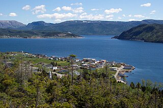
Lark Harbour is small fishing community on the western coast of Newfoundland, on the south side of the Bay of Islands, and west of the City of Corner Brook.

Bay Bulls is a small fishing town in the province of Newfoundland and Labrador, Canada.

Burnt Islands is a small coastal community found in God Bay on the southwest coast of Newfoundland, Canada.

Cow Head is a town in the Canadian province of Newfoundland and Labrador. The town had a population of 478 in the Canada 2016 Census.
Jackson's Arm is a town in the Canadian province of Newfoundland and Labrador, located on White Bay. It was settled by John Wicks of Christchurch, England, around 1870. The Post Office was established in 1892 and the first Postmistress was Belinda Peddle. The town had a population of 435 in 1956 and 277 as of the 2021 Canadian census. The primary industry of the town is fishing. In 2012, the local fish plant closed.

King's Cove is a town in the Canadian province of Newfoundland and Labrador. The post office was established in 1851. Its founder was James Aylward from Keels, who was born in Ireland in county Cork in 1690. His direct descendants still live in the community.

Leading Tickles is a town in the Canadian province of Newfoundland and Labrador. In 2021, the town had a population of 296, down from 407 in the Canada 2006 Census. It is located approximately 25 km Northwest of Point Leamington on the shores of Notre Dame Bay. The town boasts spectacular scenery especially in spring and early summer when many icebergs pass just off the coast.
Salmon Cove is a town in the Canadian province of Newfoundland and Labrador. The town had a population of 764 in the Canada 2021 Census, up from 695 in 2016.
Woodstock is a town in the Canadian province of Newfoundland and Labrador. The town had a population of 195 in 2021, up from 190 in the Canada 2016 Census.
Island Harbour is a designated place in the Canadian province of Newfoundland and Labrador.
Mattis Point is a local service district and designated place in the Canadian province of Newfoundland and Labrador. It is in the St. George area.
Flower's Cove is a town in the Canadian province of Newfoundland and Labrador. The town had a population of 272 in the Canada 2021 Census. It is known for its thrombolite fossils.
Wild Cove is a local service district and designated place in the Canadian province of Newfoundland and Labrador. It is on the Baie Verte Peninsula of the island of Newfoundland.