Whitbourne, Newfoundland and Labrador

Last updated
Whitbourne
Town
Whitbourne.JPG
Canada Newfoundland location map.svg
Red pog.svg
Whitbourne
Location of Whitbourne in Newfoundland
Coordinates: 47°25′N53°32′W / 47.417°N 53.533°W / 47.417; -53.533
Country Flag of Canada (Pantone).svg  Canada
Province Flag of Newfoundland and Labrador.svg  Newfoundland and Labrador
Census division 1
Settled1880
Area
  Total21.41 km2 (8.27 sq mi)
Population
 (2021)
  Total955
  Density41.4/km2 (107/sq mi)
Time zone UTC-3:30 (Newfoundland Time)
  Summer (DST) UTC-2:30 (Newfoundland Daylight)
Area code 709
Highways NL TCH sign.svg Route 1 (TCH)
NL Route 80.svg Route 80
NL Route 81.svg Route 81
NL Route 100.svg Route 100

Whitbourne is a town on the Avalon Peninsula in Newfoundland and Labrador, Canada in Division 1.

Contents

History

Whitbourne, Newfoundland's first inland town, is named after Sir Richard Whitbourne, one of the most colourful early settlers of the province of Newfoundland and Labrador who wrote a book about Newfoundland that was published in 1620. Sir Richard was appointed by the High Court of the Admiralty to set up the first English law court in the New World in 1615 in Trinity. He was kidnapped and held by the notorious Pirate Peter Easton in Harbour Grace. He also described a mermaid that he saw in St. John's harbour. Later, he became governor of Renews on the Southern Shore.

Whitbourne, unlike most communities on the Island of Newfoundland is inland. It was founded in about 1880 during the construction of the Newfoundland Railway. The railway continued to be an important employer in the Town until its abandonment in 1988, although its economic significance declined gradually throughout the twentieth century.

Sir Robert Bond, the prime minister from 1900 to 1909, played a role in the expansion and planning of the Town and developed an elaborate country home, the "Grange", there. The house is no longer in existence, but part of the estate is now Sir Robert Bond Park, which is noted for an unusual abundance of northern lichens including the relatively rare Degelia plumbea or blue felt lichen Degelia.

Present day

The town of Whitbourne is located just off the Trans-Canada Highway on Route 81. It is located at the centre of three possible routes to visit the Avalon Peninsula. Route 80 is one of the two entrances to the Baccalieu Trail, Route 100 and Route 81 lead to the Marine Atlantic Ferry Service in Argentia and other parts of Placentia and St. Mary's Bays, and Route 1, the Trans Canada leads towards the second entrance to the Baccalieu Trail and the capital city of St. John's. As a result, there is a Provincial Visitor Information Centre on the Trans Canada near the town.

Whitbourne has many of the amenities of a small town that has traditionally been a regional service centre. The town's Wetlands Conservation Trail is of interest to many visitors.

Demographics

In the 2021 Census of Population conducted by Statistics Canada, Whitbourne had a population of 955 living in 419 of its 584 total private dwellings, a change of

Notable people

See also

Related Research Articles

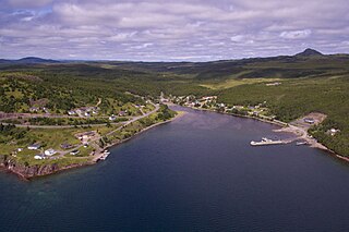
Conception Harbour is a town on the Avalon Peninsula in Newfoundland and Labrador, Canada. It is in Division 1 on Conception Bay and can be accessed via Newfoundland and Labrador Route 60.

Division No. 1, Subdivision A is an unorganized subdivision on the Avalon Peninsula in Newfoundland and Labrador, Canada. It is in Division No. 1, and lies between Trinity Bay and Placentia Bay.

<span class="mw-page-title-main">Sunnyside, Newfoundland and Labrador</span> Town in Newfoundland and Labrador, Canada

Sunnyside is a town on the Avalon Peninsula in Newfoundland and Labrador, Canada. It is in Division 1 on Bull Arm.

Clarenville is a town on the east coast of Newfoundland in the province of Newfoundland and Labrador, Canada. Clarenville was incorporated in 1951. It is located in the Shoal Harbour valley, fronting an arm of the Atlantic Ocean called Random Sound.

<span class="mw-page-title-main">Ferryland</span> Town in Newfoundland and Labrador, Canada

Ferryland is a town in Newfoundland and Labrador on the Avalon Peninsula. According to the 2021 Statistics Canada census, its population is 371.

<span class="mw-page-title-main">Division No. 1, Newfoundland and Labrador</span> Census division in Newfoundland and Labrador, Canada

Division 1, Newfoundland and Labrador is a census division covering the entire Avalon Peninsula including the Isthmus of Avalon of the Canadian province of Newfoundland and Labrador. Like all census divisions in Newfoundland and Labrador, but unlike the census divisions of some other provinces, the division exists only as a statistical division for census data, and is not a political entity.

<span class="mw-page-title-main">Avalon (electoral district)</span> Federal electoral district in Newfoundland and Labrador, Canada

Avalon is a federal electoral district on Newfoundland Island in Newfoundland and Labrador, Canada. It has been represented in the House of Commons of Canada since 2004.

Chapel Arm is a settlement in Newfoundland, Canada, located at the southeast corner of Trinity Bay, approximately 100 km (62 mi) west of St. John's and two km from the Trans-Canada Highway.

The community of Hant's Harbour is an incorporated town having a population of 318 located on the east side of Trinity Bay on the Bay de Verde Peninsula, Newfoundland, Canada.

<span class="mw-page-title-main">Heart's Content, Newfoundland and Labrador</span> Town in Newfoundland and Labrador, Canada

Heart's Content is an incorporated town in Trinity Bay on the Bay de Verde Peninsula of Newfoundland and Labrador, Canada.

Victoria is an incorporated town in Conception Bay located approximately midway on the Bay de Verde Peninsula of Newfoundland and Labrador, Canada.

<span class="mw-page-title-main">Northern Bay, Newfoundland and Labrador</span>

Northern Bay is a small community on the northern tip of Conception Bay on the Bay de Verde Peninsula, Subdivision 1G, Newfoundland and Labrador, Canada.

<span class="mw-page-title-main">Trinity, Newfoundland and Labrador</span> Town in Newfoundland and Labrador, Canada

Trinity is a small town located on Trinity Bay in Newfoundland and Labrador. The town contains a number of buildings recognized as Registered Heritage Structures by the Heritage Foundation of Newfoundland and Labrador.

Bay de Verde is an incorporated town in Conception Bay on the northern tip of the Bay de Verde Peninsula of Newfoundland and Labrador, Canada. The first recorded inhabitants at Bay de Verde arrived in 1662. Bay de Verde became an incorporated town in 1950.

<span class="mw-page-title-main">Bay Roberts</span> Town in Newfoundland and Labrador, Canada

Bay Roberts is located on the north shore of Conception Bay on the northeastern Avalon Peninsula in the province of Newfoundland and Labrador, Canada. The growth of the local economy can be connected to the town's proximity to other major Newfoundland markets, by road and by water.

New Perlican is a town in the Canadian province of Newfoundland and Labrador. The town had a population of 200 in the Canada 2021 Census.

Winterton is a town in the Canadian province of Newfoundland and Labrador. It was originally named Sille Cove or Scilly Cove. In 1912 the town was named Winterton for Sir James Spearman Winter, former Prime Minister of Newfoundland.

Cavendish is a local service district and designated place in the Canadian province of Newfoundland and Labrador.

New Harbour is a local service district and designated place in the Canadian province of Newfoundland and Labrador. It is on the east shore of Trinity Bay, along Provincial Route 80. Route 80's intersection with Route 73 is inside New Harbour.

<span class="mw-page-title-main">Division No. 1, Subdivision G, Newfoundland and Labrador</span> Unorganized territory in Newfoundland and Labrador, Canada

Division No. 1, Subdivision G is an unorganized subdivision on the Avalon Peninsula in Newfoundland and Labrador, Canada. It is in Division 1 and contains the unincorporated communities of Baccalieu Island, Besom Cove, Bradley's Cove, Burnt Point, Caplin Cove, Daniel's Cove, Grates Cove, Gull Island, Job's Cove, Kingston, Long Beach, Lower Island Cove, Low Point, Northern Bay, Ochre Pit Cove, Red Head Cove, Riverhead, Smooth Cove and Western Bay.

References

  1. "Population and dwelling counts: Canada, provinces and territories, census divisions and census subdivisions (municipalities), Newfoundland and Labrador". Statistics Canada. February 9, 2022. Retrieved March 15, 2022.

Coordinates: 47°25′N53°32′W / 47.417°N 53.533°W / 47.417; -53.533