Branch, Newfoundland and Labrador

Last updated

Town of Branch
Town
Branch, Newfoundland.jpg
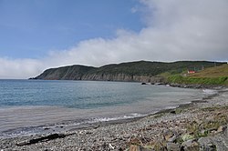
View of the town of Branch from Route 92
Canada Newfoundland location map.svg
Red pog.svg
Town of Branch
Location of Branch in Newfoundland
Coordinates: 46°53′00″N53°58′00″W / 46.88333°N 53.96667°W / 46.88333; -53.96667
Country Flag of Canada (Pantone).svg  Canada
Province Flag of Newfoundland and Labrador.svg Newfoundland and Labrador
Government
  MayorKelly Power
Area
[1]
  Land16.18 km2 (6.25 sq mi)
Population
 (2021) [1]
  Total
223
  Density13.8/km2 (36/sq mi)
Time zone UTC-3:30 (Newfoundland Time)
  Summer (DST) UTC-2:30 (Newfoundland Daylight)
Area code 709
Highways NL Route 92.svg Route 92
NL Route 100.svg Route 100

The Town of Branch is an incorporated community of Newfoundland and Labrador, Canada and had a population of 223 (as of the 2021 census). [1]

Contents

Geography

Branch Cove Fossiliferous Rocks BranchNL FossilCliffs.jpg
Branch Cove Fossiliferous Rocks

It is located on St. Mary's Bay and can be accessed via Route 100 or Route 92. Nearby communities include Point Lance and St. Bride's, Newfoundland and Labrador.

History

The first settler of Branch was Thomas Nash, an Irish fisherman and boat builder. He arrived in Caplin Bay (Calvert) on the Southern Shore in 1765 and eventually came to Branch in the year 1790.

Demographics

In the 2021 Census of Population conducted by Statistics Canada, Branch had a population of 177 living in 96 of its 142 total private dwellings, a change of

References

  1. 1 2 3 Statistics Canada, 'Population and dwelling count amendments, 2021 Census', 2023.
  2. "Population and dwelling counts: Canada, provinces and territories, census divisions and census subdivisions (municipalities), Newfoundland and Labrador". Statistics Canada. February 9, 2022. Retrieved March 15, 2022.

Commons-logo.svg Media related to Branch, Newfoundland and Labrador at Wikimedia Commons